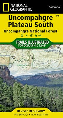
Wandelkaart - Topografische kaart 146 Uncompahgre Plateau South | National Geographic

0
Prachtige geplastificeerde kaart van het bekende nationaal park. Met alle recreatieve voorzieningen als campsites, maar ook met topografische details en wandelroutes ed. Door uitgekiend kleurgebruik zeer prettig in gebruik. Scheur en watervast!   National Geographic's Trails Illustrated map of Uncompahgre Plateau South is a two-sided, waterproof ...

Verkopers met dit product

Webshop
Bezorging
Prijs
DeZwerver.nl logo
DeZwerver.nl
2,95
17,95

Anderen bekeken ook

Nieuw
Wandelkaart - Topografische kaart 746 Adirondack Park - Saranac - Paul Smiths | National Geographic
Prachtige geplastificeerde kaart van het bekende nationaal park. Met alle recreatieve voorzieningen als campsites, maar ook met topografische details en wandelroutes ed. Door uitgekiend kleurgebruik zeer prettig in gebruik. Scheur en watervast!   National Geographic's Trails Illustrated map of Adirondack Park Saranac/Paul Smiths is a two-sided, waterproof, topographic trail map designed to meet the needs of outdoor enthusiasts with unmatched durability and detail. This map was created in cooperation with the Adirondack Mountain Club and is loaded with valuable recreation information, from the marsh to the forest, alongside lakes and through historic neighborhoods. Trails and major roads are clearly distinguished, along with canoe access and ski areas. Campgrounds, lookout towers, rock climbing, and fishing easements are labeled and easy to find and boundaries for park lands, wilderness, primitive, forest, and protected areas are clearly marked. Discover the Adirondack's wild, rugged a…
17,95
Wandelkaart - Topografische kaart OL38 OS Explorer Map Loch Lomond South | Ordnance Survey
Met zijn 4cm voor 1 km (2 ½ cm voor 1 mijl) schaal, is de OS Explorer kaartenserie de ideale en meest gedetailleerde kaartenreeks voor mensen die graag outdoor-activiteiten zoals fietsen, wandelen, paardrijden, klimmen en watersporten. Deze kaart is nog gedetailleerder dan de 'gewone' Landranger maps. Voor- en achterzijde bedrukt! Zeker op de moors en andere natuurgebieden van onschatbare waarden met echt alle aspecten van het landschap op de kaart ingetekend. Zeer goede detailkaart met topografische ondergrond. Hierop zijn toeristische symbolen van bezienswaardigheden ingetekend, daarnaast staan bijvoorbeeld campings en jeugdherbergen vermeld en - voor wandelaars het belangrijkst - alle right of way paden en Lange afstands Wandelpaden zijn er op te vinden. De ideale kaart voor het wandelen in Engeland, Wales of Schotland.   Map sheet number OL 38 covers Loch Lomond South, Helensburgh and Dumbarton. Highlights include the Loch Lomond and The Trossarchs National Park and the Argyll For…
19,50
Nieuw
Wandelkaart - Topografische kaart 821 Columbia River Gorge National Scenic Area | National Geographic
Prachtige geplastificeerde kaart van het bekende nationaal park. Met alle recreatieve voorzieningen als campsites, maar ook met topografische details en wandelroutes ed. Door uitgekiend kleurgebruik zeer prettig in gebruik. Scheur en watervast! Considered one of the best year-round outdoor recreation areas in the country, the Columbia River Gorge contains countless opportunities for hikers, climbers, kayakers, cyclists, windsurfers, and winter sports enthusiasts alike. The 80 mile long gorge contains diverse ecosystems ranging from the lush Oneonta Gorge Rain Forest to the arid Celilo Grasslands.   Our detailed Trails Illustrated recreation map of the Columbia River Gorge contains carefully researched trails, campsites, forest service roads, and points-of-interests and adjoins our Mt. Hood map.   Backcountry users will find the UTM and Latitude/Longitude grids as well as other accurate navigation features perfect for exploring the region confidently and safely.   Areas included on the…
17,95
Wandelkaart - Topografische kaart 161 OS Explorer Map London South (greenw.m) | Ordnance Survey
Follow the Thames Path through the heart of London’s oldest and most historic areas. Discover Westminster, a square mile densely packed with some of the world’s most famous attractions: Buckingham Palace, Westminster Abbey, Westminster Cathedral and the Palace of Westminster, home to the Houses of Parliament.    Visit the World Heritage Sites of Kew Gardens, Maritime Greenwich including the Royal Observatory and the Palace of Westminster & Abbey complex  Explore the suburbs of Croydon, Esher and Twickenham, home of English rugby and Horace Walpole’s miniature Gothic castle, Strawberry Hill  Walk or cycle the Thames Path National Trail or recreational paths including the London Loop and Vanguard Way  Met zijn 4cm voor 1 km (2 ½ cm voor 1 mijl) schaal, is de OS Explorer kaartenserie de ideale en meest gedetailleerde kaartenreeks voor mensen die graag outdoor-activiteiten zoals fietsen, wandelen, paardrijden, klimmen en watersporten. Deze kaart is nog gedetailleerder dan de 'gewone' L…
19,50
Nieuw
Wandelkaart - Topografische kaart 201 Trails Illustrated Yellowstone National Park | National Geographic
Prachtige geplastificeerde kaart van het bekende nationaal park. Met alle recreatieve voorzieningen als campsites, maar ook met topografische details en wandelroutes ed. Door uitgekiend kleurgebruik zeer prettig in gebruik. Scheur en watervast! National Geographic's Trails Illustrated map of Yellowstone National Park is designed to meet the needs of outdoor enthusiasts by combining valuable information with unmatched detail of America's first national park. Expertly researched and created in partnership with local land management agencies, this map features key points of interest including Mammoth Hot Springs, Canyon Village, Yellowstone Lake, Yellowstone Falls, Grant Village, and Old Faithful geyser area.   With over 1,000 miles of mapped trails, the Yellowstone National Park map can guide you off the beaten path and back again. The clearly marked trails include mileages between intersections. Trail summaries provide elevation, duration, and difficulty for a variety of suggested hike…
16,95
Nieuw
Wandelkaart - Topografische kaart 261 Grand Canyon | National Geographic
Prachtige geplastificeerde kaart van het bekende nationaal park. Met alle recreatieve voorzieningen als campsites, maar ook met topografische details en wandelroutes ed. Door uitgekiend kleurgebruik zeer prettig in gebruik. Scheur en watervast!   Explore the uniquely inspiring and wondrous landscape of the Grand Canyon with National Geographic's Trails Illustrated map of Grand Canyon National Park, North and South Rims. Expertly researched and created in partnership with local land management agencies, this map is designed to meet the needs of outdoor enthusiasts with unmatched detail of the heart of the park. Key areas of interest featured on this map include Colorado River miles 60-98, North and South Rim visitor centers, Grand Canyon Village, Tusayan, Bright Angel Trail (plus elevation profile), West Rim Trail, Kaibab Trail, Arizona Trail, and more.   With miles of mapped trails in some of the most breathtaking scenery in the entire country, the Grand Canyon North and South Rims ma…
16,95
Wandelkaart - Topografische kaart OL08 OS Explorer Map Chichester, South Harting & Selsey | Ordnance Survey
Explore the South Downs National Park, follow the South Downs Way up to the picturesque village of South Harting sheltered beneath Harting Down. Discover Chichester Harbour with its delightful fishing villages or range further afield to Selsey at the tip of the Manhood Peninsula.    Seek unspoiled coastlines and countryside on Hayling Island, where windsurfing was invented  Marvel at Chichester’s intact Roman walls and cathedral tower now home to a family of peregrine falcons  Walk or cycle the South Downs Way through gorgeous countryside past South Harting, or explore Chichester Harbour on the Sussex Border Path and Shipwrights Way    Met zijn 4cm voor 1 km (2 ½ cm voor 1 mijl) schaal, is de OS Explorer kaartenserie de ideale en meest gedetailleerde kaartenreeks voor mensen die graag outdoor-activiteiten zoals fietsen, wandelen, paardrijden, klimmen en watersporten. Deze kaart is nog gedetailleerder dan de 'gewone' Landranger maps. Voor- en achterzijde bedrukt! Zeker op de moors e…
19,50
Wandelkaart - Topografische kaart OL48 OS Explorer Map Ben Lawers & Glen Lyon | Ordnance Survey
Met zijn 4cm voor 1 km (2 ½ cm voor 1 mijl) schaal, is de OS Explorer kaartenserie de ideale en meest gedetailleerde kaartenreeks voor mensen die graag outdoor-activiteiten zoals fietsen, wandelen, paardrijden, klimmen en watersporten. Deze kaart is nog gedetailleerder dan de 'gewone' Landranger maps. Voor- en achterzijde bedrukt! Zeker op de moors en andere natuurgebieden van onschatbare waarden met echt alle aspecten van het landschap op de kaart ingetekend. Zeer goede detailkaart met topografische ondergrond. Hierop zijn toeristische symbolen van bezienswaardigheden ingetekend, daarnaast staan bijvoorbeeld campings en jeugdherbergen vermeld en - voor wandelaars het belangrijkst - alle right of way paden en Lange afstands Wandelpaden zijn er op te vinden. De ideale kaart voor het wandelen in Engeland, Wales of Schotland.   From Loch Lyon to Loch Tay, this the OL 48 map covers some of the most beautiful areas of the country. With many of the Monros, Tay Forest Park, part of Loch Lomo…
19,50
Wandelkaart - Topografische kaart 146 OS Explorer Map Dorking, Box Hill, Reigate | Ordnance Survey
Unearth the rich history and pastoral charms of the Surrey Hills, an Area of Outstanding Natural Beauty, and visit the historic market towns of Dorking, Leatherhead, Reigate and Caterham. Climb Box Hill, the world’s favourite cyclist hill climb, for stunning views of the North Downs.    Marvel at the 18th-century landscape park of Painshill, the Edwardian charm of Polesden Lacey and Reigate’s medieval castle  Spot Adonis blue butterflies and bee orchids, picnic by the Stepping Stones or climb Box Hill for its sensational vistas of the North Downs and High Weald  Ramble, hike and cycle along paths including the North Downs Way, Greensand Way and Mole Gap Trail    Met zijn 4cm voor 1 km (2 ½ cm voor 1 mijl) schaal, is de OS Explorer kaartenserie de ideale en meest gedetailleerde kaartenreeks voor mensen die graag outdoor-activiteiten zoals fietsen, wandelen, paardrijden, klimmen en watersporten. Deze kaart is nog gedetailleerder dan de 'gewone' Landranger maps. Voor- en achterzijde b…
19,50
Wandelkaart - Topografische kaart OL37 OS Explorer Map Cowal East | Ordnance Survey
Met zijn 4cm voor 1 km (2 ½ cm voor 1 mijl) schaal, is de OS Explorer kaartenserie de ideale en meest gedetailleerde kaartenreeks voor mensen die graag outdoor-activiteiten zoals fietsen, wandelen, paardrijden, klimmen en watersporten. Deze kaart is nog gedetailleerder dan de 'gewone' Landranger maps. Voor- en achterzijde bedrukt! Zeker op de moors en andere natuurgebieden van onschatbare waarden met echt alle aspecten van het landschap op de kaart ingetekend. Zeer goede detailkaart met topografische ondergrond. Hierop zijn toeristische symbolen van bezienswaardigheden ingetekend, daarnaast staan bijvoorbeeld campings en jeugdherbergen vermeld en - voor wandelaars het belangrijkst - alle right of way paden en Lange afstands Wandelpaden zijn er op te vinden. De ideale kaart voor het wandelen in Engeland, Wales of Schotland.   Map sheet number OL 37 covers Cowal East, Dunoon and Inveraray. Highlights include Loch Lomond and The Trossachs National Park, Argyll Forest Park and Kyles of Bu…
19,50

Klanten-reviews van Wandelkaart - Topografische kaart 146 Uncompahgre Plateau South | National Geographic

Er zijn nog geen beoordelingen voor dit productBen jij de eerste die een review plaatst?

Meer over Wandelkaart - Topografische kaart 146 Uncompahgre Plateau South | National Geographic

Productomschrijving

Prachtige geplastificeerde kaart van het bekende nationaal park. Met alle recreatieve voorzieningen als campsites, maar ook met topografische details en wandelroutes ed. Door uitgekiend kleurgebruik zeer prettig in gebruik. Scheur en watervast!   National Geographic's Trails Illustrated map of Uncompahgre Plateau South is a two-sided, waterproof map designed to meet the needs of outdoor enthusiasts with unmatched durability and detail. This map was created in conjunction with local land management agencies and is loaded with valuable recreation information.   The front side of the map details the southeastern portion of the Plateau and Uncompahgre National Forest, as well as Ridgway State Park. On the reverse side of the map, the southwestern portion of Uncompahgre National Forest, including the Naturita Division, is featured as well as the Tabeguache Area, Roubideau Special Management Area, Unaweep/Tabeguache Scenic and Historic Byway, and Dry Creek Basin and Dan Noble State Wildlife Areas.   The Uncompahgre Plateau South map is printed in the United States on durable synthetic paper, making it waterproof, tear-resistant, and trail tough — capable of going anywhere you do. The map is two-sided, and can be folded to a packable size of 4.25" x 9.25"; unfolded size is 26" x 38".   Net proceeds from the sale of this map go to support the nonprofit mission of the National Geographic Society.   Key Features:
  • Waterproof and tear-resistant
  • Detailed road network and clearly marked trails for hiking, biking, horseback riding, skiing, ATV and more
  • Detailed topography and clearly defined, color-coded boundaries of national forests, state parks, wilderness areas, and wildlife refuges
  • Hundreds of points-of-interest, including trailheads, campgrounds, boat launches, fishing, ranger stations and more
  • UTM and Latitude/Longitude grid, as well as selected waypoints and a scale bar for easy and accurate navigation.
  • Useful information on United States Forest Service trail travel management and vehicle use
  • Important contact information for local land management agencies
  • Information on special areas including Roubideau Special Management Area and Tabeguache Area
 

Verken gerelateerde categorieën

Webshop.nl maakt gebruik van cookies. Ga je verder op onze website, ga dan akkoord met het plaatsen van cookies en de verwerking van deze data door ons en vermelde partners.