Productomschrijving
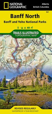
Prachtige geplastificeerde kaart van het bekende nationaal park. Met alle recreatieve voorzieningen als campsites, maar ook met topografische details en wandelroutes ed. Door uitgekiend kleurgebruik zeer prettig in gebruik. Scheur en watervast!
The front side of the Banff North map details the south side of the national park, from Siffleur Wilderness Area to the north, to Kootenay National Park to the south. This side also covers survival tips, area trails, entry fees and details both Kootenay and Yoho Nationals Parks. The reverse side of the map details the north side of the park, extending from Siffleur Wilderness area to the south, to White Goat Wilderness to the North. Insets show safe travel in Bear Country, and all the recreation the park has to offer with backpacking, camping, biking, hiking and horseback riding.
National Geographic's Trails Illustrated map of Banff North is a two-sided, waterproof map designed to meet the needs of outdoor enthusiasts with unmatched durability and detail. This map was created in conjunction with local land management agencies and is loaded with valuable recreation information. Trails Illustrated maps are expertly researched and frequently updated. The maps are printed in the United States on durable synthetic paper, making them waterproof, tear-resistant, and trail tough — capable of going anywhere you do. The map is two-sided, and can be folded to a packable size of 4.25” x 9.25”; unfolded size is 26” x 38”. Net proceeds from the sale of this map go to support the nonprofit mission of the National Geographic Society. Key Features: - Waterproof and tear-resistant - Clearly marked trails for hiking, biking, horseback riding, and more - Detailed topography and clearly defined, color-coded boundaries of state parks, national recreation areas, wilderness areas, marine sanctuaries and wildlife refuges - Hundreds of points-of-interest, including scenic viewpoints, campgrounds, boat launches and canoe carry downs, swimming areas, fishing access points, and more - UTM and Latitude/Longitude grid, as well as selected waypoints and a scale bar for easy and accurate navigation. - Detailed road network - Useful travel information on parks and key trails - Important safety information and tips - Information about local organizations and land management agencies