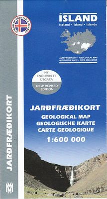
Wegenkaart - landkaart Geologische kaart van IJsland - Jardfraedikort | Mal og Menning

0
Prachtige geologische kaart van IJsland. Aan de hand van veel verschillende kleuren wordt de samenstelling, leeftijd en type van de bodem duidelijk weergegeven. Voor een eiland als IJsland zeer aan te raden! The Geological Map of Iceland shows the main features of the bedrock geology. Formations are classified by age, type and composition. The map...

Verkopers met dit product

Webshop
Bezorging
Prijs
DeZwerver.nl logo
DeZwerver.nl
niet bekend
22,50

Anderen bekeken ook

Natuurgids Hvalakort Walviskaart Ijsland | Mal og Menning
De walviskaart toont alle belangrijke walvissoorten rond IJsland, inclusief verspreidingskaarten en informatie over grootte en leeftijd. The Whale Map shows all the major whale species around Iceland, including distribution maps and information about sizes and age. The water-colour illustrations are by Jón Baldur Hlíðberg. The Whale Map is an essential companion for all nature lovers who want to learn more about Iceland´s whales on their travels around the country. All text is in Icelandic, English, German and French.
22,50
Vogelgids Birdwatcher's Map of Iceland / Vogelkaart van IJsland | Mal og Menning
Handige kaart met kleine gids van de verspreiding en het voorkomen van de meest bekende en opmerkelijke vogels van IJsland. Erg makkelijk als de reis naar IJsland in het teken staat van vogels! A simple and accessible guide to Iceland's birdlife, covering 70 species ofbreeding bird and 37 migrants, winter visitors and vagrant. Breeding birdsare pictured together with maps showing their distribution and illustrations indicating the size and appearance of their eggs. The map is based on thebook Íslenskir fuglar (Icelandic Birds) by Ævar Petersen an ornithologistwith the Icelandic Institute of Natural History. The water-colourillustrations are by Jón Baldur Hlíðberg. The Birdwatcher's Map of Iceland is an essential companion for all naturelovers who want to learn more about Iceland's birdlife on their travelsaround the country.
22,50
Topografische kaart Höggunakort Tectonic Map of Iceland | Mal og Menning
The Höggunarkort is a map about tectonics in Iceland. On the front side you will find a 1:600,000 map of the island with the different layers of land differentiated according to their period of formation and not their composition, but also various volcanic formations.   On the back, photos and explanatory texts illustrate, among other things, the terms of the legend (period and volcanic formations). Some of the concepts developed are: fault, Tertiary, Miocene, caldera, central volcano...
22,50
Natuurgids Botanical map Ijsland | Mal og Menning
The botanical map provides clear and accessible information on Iceland's main plants. It shows 78 flowering plants, together with distribution maps and information on size, habitat and season of flowering. The map also includes pictures of Iceland's principal cryptograms (spore-bearing plants), grasses, algae, lichens and fungi. The map's sources include Flowering Plants and Ferns of Iceland by Hörður Kristinsson. The watercolour illustrations areby Jón Baldur Hlíðberg, one of the authors of the Mál og menning Birdwatchers' Map. The botanical map is indispensable to all lovers of Icelandic nature, who wish to learn about Icelandic flora on their travels.
22,50
Wegenkaart - landkaart Chobe | Shell
Zeer bijzondere goede landkaart van Chobe National Park in Botswana. Uitermate handig zijn de GPS coordinaten van de meest belangrijke punten als campings of uitzichtpunten. De kaart is gebaseerd op een luchtfoto, waarbij alle details zijn ingetekend. The map: The Chobe map consists of a complete map of Chobe on the front of the map and there are 5 individual maps of the major tourist areas on the back of the map. These are Chobe river front east, Chobe river front west, Nogatsaa, Savute and a small orientation map. The map was compiled by using satellite images, giving one a birds eye-view of the area. The roads were tracked by means of a GPS and then super-imposed on the photographs. Detailed GPS co-ordinates are supplied for game-drive areas. The Chobe map contains 126 GPS co-ordinates. The four main tourist areas: The Chobe National Park consists of a variety of vegetation types and geological features, offering extreme contrasts and a wide range of wildlife experiences within the…
17,50
Wegenkaart - landkaart The Cotswolds | Philip's Maps
A new edition of this double-sided map of the Cotswolds clearly featuring places of tourist and historic interest in an easy-to-read style of mapping, alongside six handy town centre plans. This leisure and tourist map of the Cotswolds gives detailed coverage of the area's road network at a scale of approximately 2 miles to 1 inch (1:125,000). The coverage stretches from Abingdon in the east to Gloucester in the west, and from Swindon in the south to Great Malvern in the north. The map shows places of tourist and historic interest, including castles, camping and caravanning sites, country parks, galleries, gardens, golf courses, museums, nature trails, historic sites, sports venues, theatres and wildlife parks. An index to principal places of interest is also featured. With some of the most enchanting towns and cities in England in the area - all with extraordinary history and notable natural beauty - use the Philip's Leisure Map to explore and delight in the Cotswold magic. Includ…
11,50
Wegenkaart - landkaart Thailand | Freytag & Berndt
Gedetailleerde, tweezijdige landkaart van Thailand, prima geschikt voor planning en rondtrekken over alle eilanden. De berijdbare wegen zijn goed weergeven, zowel de hoofdwegen als provinciale en lokale wegen; wegnummers worden vermeld. Afstanden tussen plaatsen zijn in kilometers op de kaart ingetekend, daarnaast worden ook op belangrijke plekken benzinepompen gemarkeerd. In het kaartbeeld wordt door middel van schaduw het reliëf weergegeven en soms enkele punten in het landschap met de daadwerkelijke hoogte. Provinciegrenzen zijn goed terug te vinden, nationale parken en reservaten ook. Met allerhande symbolen worden toeristische bezienswaardigheden weergegeven als monumenten, historisch belangrijke plekken en uitzichtpunten. In bepaalde plaatsen zijn hotels en campings te vinden, luchthavens, treinverbindingen en havens vindt u er ook op! Thailand on a large, double-sided, indexed road map from Freytag & Berndt, with clear presentation of the countrys road network, its topography, …
14,95
Nieuw
Wegenkaart - landkaart Explorer Map North Queensland | Hema Maps
Detailkaart van een deel van Australië. Zeer goed leesbaar, met naast de topografische details veel symbolen waarmee allerhande toeristische zaken worden aangeduid als campsites, nationale parken, attracties, wandelmogelijkheden etc. Covering Australia's beautiful North Queensland. There is alot of town map insets, tourist information, and photographs on the reverse side Touring map of the northern half of Queensland, with enlargements of popular areas, street plans, lists of facilities, etc. The main map extends south to well beyond the Flinders Highway between Townsville and Mount Isa, including Mackay on the coast. The map shows the road network, including minor roads and unsurfaced tracks, plus railways and local airfields/aerodromes. Designated Tourist Routes are highlighted and symbols mark places of interest (many annotated with brief description), historical sites, tourist resorts, youth hostels, etc. Topography is indicated by names of mountain ranges and peaks, as well as by…
17,50
Fotoboek Lost in Iceland | Mal og Menning
Eén van IJsland's meest gerenomeerde fotografen heeft een schitterend fotoboek samengesteld van dit magische land. Mooie uitvoering, harde kaft. Stunning colour photographs of the barren beauty of the Icelandic landscape. The sounds evoked by Sigurgeir Sigurjonsson's photographs are the eternal sounds of nature - the sighing of the wind, the lapping of waves, the hissing of steam and the unchanging roar of a waterfall. In the elemental world of these pictures, man is largely absent. The brief initimate glimpses we are given of human life - a farmhouse kitchen, a man fishing, a family attending the lambing - only serve to underline the overwhelming emptiness of the Icelandic landscape. It is these very qualities of peace, quiet and solitude that many visitors are seeking when they come to iceland - one of the last places in Europe where you can lose yourself in a wilderness seemingly untouched by man. Lost in Iceland is an astounding book presenting pictures of superb quality. Iceland …
56,95
Wegenkaart - landkaart Costa Blanca Valencia | Marco Polo
Goede wegenkaart van een deel van Spanje,met schaal 1:200.000: meer details dan de Michelin wegenkaarten van Spanje. Deze kaarten hebben een register, een tabel met afstanden tussen steden, enkele centrumkaarten van de meest belangrijke steden, vermelding van o.a. campings aan de hand van symbolen alsmede de bezienswaardigheden. Ook benzinepompen worden bijvoorbeeld vermeld! The map boldly stresses main roads and motorways in strong colours and selected towns in large letters, but also shows minor roads and villages in considerable detail. Road information includes toll roads, traffic restrictions and seasonal closures, gradient marking for steep roads, scenic roads and special tourist routes, etc. Motorway services clearly indicate types of facilities available there. Railway network is shown with stations and includes tourist lines Picturesque towns or villages and sites worth visiting, including areas with interesting landscape, are given star rating, and other tourist information …
14,95

Klanten-reviews van Wegenkaart - landkaart Geologische kaart van IJsland - Jardfraedikort | Mal og Menning

Er zijn nog geen beoordelingen voor dit productBen jij de eerste die een review plaatst?

Meer over Wegenkaart - landkaart Geologische kaart van IJsland - Jardfraedikort | Mal og Menning

Productomschrijving

Prachtige geologische kaart van IJsland. Aan de hand van veel verschillende kleuren wordt de samenstelling, leeftijd en type van de bodem duidelijk weergegeven. Voor een eiland als IJsland zeer aan te raden!

The Geological Map of Iceland shows the main features of the bedrock geology. Formations are classified by age, type and composition. The map also clearly shows the island's volcanic zones and the distribution of the recent eruption sites. Lava fields of the Holocene are shown as pre-historic or historic. This is the second, revised, edition of the map.

Verken gerelateerde categorieën

Webshop.nl maakt gebruik van cookies. Ga je verder op onze website, ga dan akkoord met het plaatsen van cookies en de verwerking van deze data door ons en vermelde partners.