Wegenkaart - landkaart Chobe | Shell

0
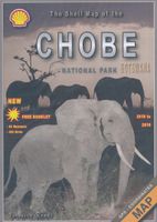
Zeer bijzondere goede landkaart van Chobe National Park in Botswana. Uitermate handig zijn de GPS coordinaten van de meest belangrijke punten als campings of uitzichtpunten. De kaart is gebaseerd op een luchtfoto, waarbij alle details zijn ingetekend. The map: The Chobe map consists of a complete map of Chobe on the front of the map and there are ...

Verkopers met dit product

Verkoper
Bezorging
Prijs
DeZwerver.nl logo
DeZwerver.nl
2,95
17,50

Anderen bekeken ook

Wegenkaart - landkaart Chobe | Shell
Zeer bijzondere goede landkaart van Chobe National Park in Botswana. Uitermate handig zijn de GPS coordinaten van de meest belangrijke punten als campings of uitzichtpunten. De kaart is gebaseerd op een luchtfoto, waarbij alle details zijn ingetekend. The map: The Chobe map consists of a complete map of Chobe on the front of the map and there are 5 individual maps of the major tourist areas on the back of the map. These are Chobe river front east, Chobe river front west, Nogatsaa, Savute and a small orientation map. The map was compiled by using satellite images, giving one a birds eye-view of the area. The roads were tracked by means of a GPS and then super-imposed on the photographs. Detailed GPS co-ordinates are supplied for game-drive areas. The Chobe map contains 126 GPS co-ordinates. The four main tourist areas: The Chobe National Park consists of a variety of vegetation types and geological features, offering extreme contrasts and a wide range of wildlife experiences within the…
17,50
Wegenkaart - landkaart Moremi - Tourist Map of Moremi Game Reserve Botswana | Shell
Zeer bijzondere landkaart van Moreni Game Reserve in Botswana. Uitermate handig zijn de GPS coördinaten van de meest belangrijke punten als campings of uitzichtspunten. De kaart is gebaseerd op een luchtfoto, waarbij alle details zijn ingetekend. The map: The Moremi map is based on satellite photos. The front of the map consists of a map of the entire Reserve and on the back are six separate maps of Khwai river-front east, Khwai river-front west, an orientation map of Moremi, Xakanaxa area and the Moanachira river, Xakanaxa game-drive area and Bodumatau area. The roads were tracked by GPS and there are 162 GPS co-ordinates on the map. General: As part of the Okavango Delta, Moremi consists of permanent swamp, seasonally swamped areas and dry land. It is one of the prime tourist destinations in Botswana and offers water activities, top game-viewing, some of the best bird-life in Africa and incredible scenery. Not to be missed! Locality and size: The Moremi Game Reserve is nestled withi…
17,50
Wegenkaart - landkaart Kgalagadi - Tourist Map of Kgalagadi Transfrontier Park Botswana | Shell
Zeer bijzondere landkaart van het grensgebied van Botswana en Zuid Afrika. Uitermate handig zijn de GPS coordinaten van de meest belangrijke punten als campings of uitzichtpunten. De kaart is gebaseerd op een luchtfoto, waarbij alle details zijn ingetekend. The map: The map consists of a large map of the entire Park on the front of the map. On the back is enlargements of six maps - the South African side, Mabuasehube, Swart Pan area, Gemsbok Wilderness Trail, Mabuasehube Wilderness Trail and of the Kaa Kalahari Concession. Satellite images were used and the roads were tracked by GPS. There are 168 GPS coordinates on this map. Establishment of a Transfrontier Park: On the 7 th of April 1999 Botswana and South Africa signed a bilateral agreement in which they agreed to manage their adjacent national parks, Gemsbok National Park in Botswana and Kalahari Gemsbok National Park in South Africa, as a single ecological unit – the Kgalagadi Transfrontier Park. It is the first formally declared…
17,50
Wegenkaart - landkaart Okavango Delta - Tourist Map of the Okavango Delta and Linyanti Botswana - Veronica Roodt | Shell
Zeer bijzondere landkaart van de Okavango Delta en Linyanti. Uitermate handig zijn de GPS coördinaten van de meest belangrijke punten als campings of uitzichtpunten. De kaart is gebaseerd op een luchtfoto, waarbij alle details zijn ingetekend. The map: The map of the Okavango and Linyanti was compiled by using LANDSAT satellite images. The main reason for a tourist map of the area is to indicate the localities of the lodges as well as the wildlife management areas in which they occur. Tourists to the Okavango often visit more than one lodge and this will give them a good idea of where they have been. On the back of the map are enlargements of the different tourist areas, which shows more detail of the landscape. There are no GPS co-ordinates on the Okavango map as all the Wildlife areas consist of private concessions, which are not open to the general public. The roads in the private concessions have also not been indicated as this may mislead the self-driving public, making them thin…
17,50
Wegenkaart - landkaart Ontario | ITMB
Een degelijke kaart voor Ontario met aanduidingen van o.a. nationale parken, vliegveld, benzinepomp, dirt-roads en kleine plattegrond van Toronto, Sault Ste. Marie. Als overzichtskaart goed te gebruiken. Ontario and Quebec form the portion of Canada known as Central Canada. Ontario is the industrial heartland of the country, and the southern portion is the most densely-populated and urbanized part of Canada. Toronto is a city of 2.8M people and the heartland of an economic region serving 100,000,000 people in two countries. Southern Ontario is also home for six million residents, some of the most historic sites in the country, and major recreational land masses (Algonquin Park, Bruce Trail, Muskoka/Haliburton). Northern Ontario, on the other side of the map, occupies the bulk of the land area of the province, and is dominated by the Canadian Shield (a pre-Cambrian rock formation that is the oldest land on earth, rich in mineral wealth). The North is dominated by recreational activitie…
13,95
Wegenkaart - landkaart Indonesië - Indonesia | ITMB
Een degelijke landkaart van Indonesië met aanduidingen van o.a. nationale parken, vliegvelden en grote wegen. Als overzichtskaart goed te gebruiken. De nadruk ligt echter vooral op de natuurkundige aspecten. Scheur- en watervast! Met een kleine kaart van Jakarta. The hundreds of islands making up the island nation of Indonesia make a double-sided map inevitable in order to show any significant amount of detail. Side 1 shows the western half, starting with Sumatra in the upper left and including Java and most of the island of Borneo (Kalimantan Province to the Indonesians). This side also includes a large inset map of central Jakarta (for better detail see our separate map of the city); ditto for Sumatra, Java, and Borneo. Bali, Lombok, and Sumbawa islands are in the lower right portion of the map, and most of Malaysia and all of Singapore are included, simply because they are there. The infamous volcanic island of Krakatoa is located just to the west of Java. The other side of the map…
13,95
Wegenkaart - landkaart Cuba West | ITMB
Een degelijke wegenkaart met aanduidingen van o.a. nationale parken, vliegveld. Als overzichtskaart goed te gebruiken. his is a brand new title for ITMB and reflects the growing interest in travel to Cuba resulting from improved relations with the USA. Licenses to fly into the country from a dozen cities have already been approved; 60 more are awaiting approval. All are for flights into Havana and Varadero airports – in other words, the western half of the country. ITMB already has an exceptionally good map of the entire country. We also have a separate map of Havana. This map expands the scale and opens the information for the western half of the island nation as a double-sided map, with the portion west of Havana (La Habana) to Pinar del Rio province in the far west and south to the Isla de la Juventud (better known, but mis-named, as the Bay of Pigs Invasion Site). This side also has an excellent map of the Varadero beach resort area as an inset, and a map of greater Havana. The ot…
13,95
Wegenkaart - landkaart Québec | ITMB
Een degelijke kaart met aanduidingen van o.a. nationale parken, vliegvelden en grote wegen. Als overzichtskaart goed te gebruiken. Tweezijdig. La Belle Province is historically rich, linguistically unique in North America, and attractive for tourism. It is a very large area of land, forcing us to portray the northern portion at a different scale than the more populated southern portion. The map extends to Ottawa in the west and includes most of New Brunswick in the east, as well as all the border areas with the USA to the south. Due to the size of Quebec, the focus of this map is concentrated on providing road information to get around, parks and geographic features, and symbols portraying ski resort areas, urban areas, and road numbers. A basic inset showing the major routes around Montreal is an added feature.   Legend Includes: Roads by classification, Points of Interest, Mines, Museums, Airports, National Parks, Rivers, Lakes, Mountain Peaks, Waterfalls, Border Crossings, Rest Are…
13,95
Wegenkaart - landkaart Brisbane to Cairns | Hema Maps
Detailkaart van een deel van Australië. Zeer goed leesbaar, met naast de topografische details veel symbolen waarmee allerhande toeristische zaken worden aangeduid als campsites, nationale parken, attracties, wandelmogelijkheden etc. An easy-to-follow map that shows both the coastal and inland routes from Brisbane to Cairns. Roadside rest areas, intermediate distances, and a quick-find distance chart are also shown. The map shows all the popular tourist destinations along the Queensland coast. Routes between Brisbane with Cairns in a series of touring maps connecting Australia’s main centres of population along some of the most spectacular routes such as the Great Ocean Road or the Savannah Way. The maps highlight 24-hour fuel supplies, roadside rest areas, camping facilities, places of interest, etc., and include distance charts and, in some titles, city maps. Road network indicates unsurfaced roads and tracks. The maps also show railway lines. There is no topographical information b…
17,50

Klanten-reviews van Wegenkaart - landkaart Chobe | Shell

Er zijn nog geen beoordelingen voor dit productBen jij de eerste die een review plaatst?

Meer over Wegenkaart - landkaart Chobe | Shell

Productomschrijving

Zeer bijzondere goede landkaart van Chobe National Park in Botswana. Uitermate handig zijn de GPS coordinaten van de meest belangrijke punten als campings of uitzichtpunten. De kaart is gebaseerd op een luchtfoto, waarbij alle details zijn ingetekend.

The map: The Chobe map consists of a complete map of Chobe on the front of the map and there are 5 individual maps of the major tourist areas on the back of the map. These are Chobe river front east, Chobe river front west, Nogatsaa, Savute and a small orientation map. The map was compiled by using satellite images, giving one a birds eye-view of the area. The roads were tracked by means of a GPS and then super-imposed on the photographs. Detailed GPS co-ordinates are supplied for game-drive areas. The Chobe map contains 126 GPS co-ordinates.

The four main tourist areas: The Chobe National Park consists of a variety of vegetation types and geological features, offering extreme contrasts and a wide range of wildlife experiences within the confines of one park. Four main tourist areas have been developed. They are as follows:

Chobe River Front - The Chobe is proud of and very famous for its abundance of elephants – the highest concentration anywhere in the world! There are also huge herds of buffalo, the Chobe bushbuck, the puku (an antelope), its rich birdlife and, not least, for its exquisite sunsets.

Linyanti - There are only 7 km of riverfront that can be used for game-drives and the road to get there is very sandy. To truly enjoy the Linyanti area one should visit one of the lodges but it is only possible to get to the lodges by air.

Savute - In sharp contrast to the lush Chobe riverfront is the almost desert-like landscape of the Savute. A scorching sun, loose, hot sand, animals escaping the heat by clumping together in the limited available shade and elephants impatiently lining up to get to the ever dwindling water supply. All of the above, offer a wildlife experience unique to Savute.

Nogatsaa area - When the pans have water, game viewing in this area is very good. Elephant activity is rife and one can watch the animals from the comfort of a hide at many of the water holes. This area is not open to the general public for camping but it is possible to visit the area on day-trips.

Productinformatie

    Verken gerelateerde categorieën

    Webshop.nl maakt gebruik van cookies. Ga je verder op onze website, ga dan akkoord met het plaatsen van cookies en de verwerking van deze data door ons en vermelde partners.