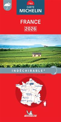
Wegenkaart - landkaart 792 Frankrijk 2026 | Indechirable | Michelin

0
Scheur- en watervast!   Zoals je van Michelin mag verwachten is deze kaart zeer overzichtelijk en heeft een duidelijk helder kaartbeeld. De kaart geeft uitgebreide toeristische informatie weer. De perfecte overzichtskaart!     Michelin’s annually updated coverage of France at 1:1,000,000, available as two folded maps or two different format pocket...

Verkopers met dit product

Verkoper
Bezorging
Prijs
DeZwerver.nl logo
DeZwerver.nl
niet bekend
2,95
12,95

Anderen bekeken ook

Wegenkaart - landkaart 792 Frankrijk 2026 | Indechirable | Michelin
Scheur- en watervast!   Zoals je van Michelin mag verwachten is deze kaart zeer overzichtelijk en heeft een duidelijk helder kaartbeeld. De kaart geeft uitgebreide toeristische informatie weer. De perfecte overzichtskaart!     Michelin’s annually updated coverage of France at 1:1,000,000, available as two folded maps or two different format pocket atlases covering the whole country, plus as separate maps of just the northern or the southern half.   The mapping emphasizes the network of motorways and dual carriageway roads with motorway characteristics, distinguishing by colouring between charge-free and toll sections. Junctions are shown with numbers, indicating complete or limited interchanges. Other roads are classified according to their width and density of traffic. Driving distances are given on all routes except on small local roads. Scenic routes are highlighted and gradient marking shows steep roads.   Railway lines are not included. Small symbols indicate some places of inter…
12,95
Wegenkaart - landkaart 721 Frankrijk 2026 | Michelin
Zoals je van Michelin mag verwachten is deze kaart zeer overzichtelijk en heeft een duidelijk helder kaartbeeld. De kaart geeft uitgebreide toeristische informatie weer. De perfecte overzichtskaart!   Deze kaart is éénzijdig met heel Frankrijk op 1 kant!   Michelin’s annually updated coverage of France at 1:1,000,000, available as two folded maps or two different format pocket atlases covering the whole country, plus as separate maps of just the northern or the southern half.   The mapping emphasizes the network of motorways and dual carriageway roads with motorway characteristics, distinguishing by colouring between charge-free and toll sections. Junctions are shown with numbers, indicating complete or limited interchanges. Other roads are classified according to their width and density of traffic. Driving distances are given on all routes except on small local roads. Scenic routes are highlighted and gradient marking shows steep roads.   Railway lines are not included. Small symbols…
11,95
Wegenkaart - landkaart 724 Frankrijk Noord | Michelin
Zoals je van Michelin mag verwachten is deze kaart zeer overzichtelijk en heeft een duidelijk helder kaartbeeld. De kaart geeft uitgebreide toeristische informatie weer. De perfecte overzichtskaart van alleen de noordelijke helft van Frankrijk. Michelin’s annually updated coverage of France at 1:1,000,000, available as two folded maps or two different format pocket atlases covering the whole country, plus as separate maps of just the northern or the southern half. The mapping emphasizes the network of motorways and dual carriageway roads with motorway characteristics, distinguishing by colouring between charge-free and toll sections. Junctions are shown with numbers, indicating complete or limited interchanges. Other roads are classified according to their width and density of traffic. Driving distances are given on all routes except on small local roads. Scenic routes are highlighted and gradient marking shows steep roads.   Railway lines are not included. Small symbols indicate some…
11,95
Wegenkaart - landkaart 725 Frankrijk Zuid | Michelin
Zoals je van Michelin mag verwachten is deze kaart zeer overzichtelijk en heeft een duidelijk helder kaartbeeld. De kaart geeft uitgebreide toeristische informatie weer. De perfecte overzichtskaart van alleen de zuidelijke helft van Frankrijk. Michelin’s annually updated coverage of France at 1:1,000,000, available as two folded maps or two different format pocket atlases covering the whole country, plus as separate maps of just the northern or the southern half.   The mapping emphasizes the network of motorways and dual carriageway roads with motorway characteristics, distinguishing by colouring between charge-free and toll sections. Junctions are shown with numbers, indicating complete or limited interchanges. Other roads are classified according to their width and density of traffic. Driving distances are given on all routes except on small local roads. Scenic routes are highlighted and gradient marking shows steep roads.   Railway lines are not included. Small symbols indicate som…
11,95
Wegenkaart - landkaart 726 Frankrijk Route Planning 2025 | Michelin
Uitgebreide algemene wegenkaart van Frankrijk. Naast de hoofdwegen worden ook alternatieve routes aangegeven.   A route planning map of France from Michelin, showing just the network of motorways and the connecting primary and secondary roads, with congested sections and alternative routes, all with distances and driving times.   The main map, plus the enlargements for the outskirts of Paris and Lyon, show the network of motorways (with toll barriers, names of service areas, and junction numbers indicating full or partial interchanges), dual carriageway roads, plus primary and secondary roads, all with both driving distances and journey times. Also marked are towns used as primary destinations on green road signs along the major routes, and locations of speed cameras. Particularly congested areas are clearly highlighted.   The map also shows Michelin’s recommendations for alternative routes to avoid traffic congestion in many popular holiday areas such as the Dordogne, Cevennes, Langu…
11,95
Wegenkaart - landkaart 738 Roemenië - Roemenie | Michelin
Zoals je van Michelin mag verwachten is deze kaart zeer overzichtelijk en heeft een duidelijk helder kaartbeeld. De kaart geeft uitgebreid toeristische informatie weer. Met register, afstanden en reistijden. Wegen worden naar verschillende klasse ingedeeld en - mooi van Michelin - de interessante mooie routes worden gemarkeerd met een groene streep.    Hindernissen voor automobilisten met caravans zijn gemarkeerd: steile hellingen, bergpassen of een anderzins moeilijke route. Bezienswaardigheden als een kasteel, religieus gebouw, ruine of grot is door een symbool goed te vinden.   The Michelin national road map of Romania at 1:750,000 scale is best suited to trip & route planning. The map gives comprehensive coverage of national road networks showing major motorways, dual carriageways, national & regional main roads and some smaller local roads. Unsurfaced roads and tracks and some major footpaths are also shown. The map shows useful motoring information for motorways and major roads …
11,95
Wegenkaart - landkaart 355 Veneto | Michelin
De Michelin kaart is actueel, gedetailleerd, nauwkeurig, praktisch en internationaal.    De Lokale Michelin streekkaart biedt u: nauwkeurige en toeristische informatie over een streek of regio, een plaatsnamenregister om uw route gedetailleerd uit te stippelen, een nog waarheidsgetrouwere weergave van de topografie door het satellietbeeld en een selectie van de mooiste plekken.   From Michelin's yellow Local series of Europe maps comes this map of Veneto at 1:200 000, showing excellent detail in this region of Italy. The map has the usual excellent road detail characteristic of Michelin maps, with everything from motorways down to rough tracks and footpaths marked out clearly. The number of lanes is indicated on most roads, with intermediate road distances, European route numbers and tolled roads also shown.   The map includes highly detailed relief shading that's derived from satellite photos, with plenty of spot heights also. View points, scenic routes, religious and historic buildi…
10,95
Wegenkaart - landkaart 362 Campania, Basilicata | Michelin
De Michelin kaart is actueel, gedetailleerd, nauwkeurig, praktisch en internationaal.  De Lokale Michelin streekkaart biedt u: nauwkeurige en toeristische informatie over een streek of regio, een plaatsnamenregister om uw route gedetailleerd uit te stippelen, een nog waarheidsgetrouwere weergave van de topografie door het satellietbeeld en een selectie van de mooiste plekken.   From Michelin's yellow Local series of Europe maps comes this map of Campania and Basilicata at 1:200 000, showing excellent detail in this region of southern Italy. The map has the usual excellent road detail characteristic of Michelin maps, with everything from motorways down to rough tracks and footpaths marked out clearly. The number of lanes is indicated on most roads, with intermediate road distances, European route numbers and tolled roads also shown.   The map includes highly detailed relief shading that's derived from satellite photos, with plenty of spot heights also. View points, scenic routes, re…
10,95
Wegenkaart - landkaart 358 Toscane - Toscana | Michelin
De Michelin kaart is actueel, gedetailleerd, nauwkeurig, praktisch en internationaal.    De Lokale Michelin streekkaart biedt u: nauwkeurige en toeristische informatie over een streek of regio, een plaatsnamenregister om uw route gedetailleerd uit te stippelen, een nog waarheidsgetrouwere weergave van de topografie door het satellietbeeld en een selectie van de mooiste plekken.   From Michelin's yellow Local series of Europe maps comes this map of Tuscany at 1:200 000, showing excellent detail in this region of Italy. The map has the usual excellent road detail characteristic of Michelin maps, with everything from motorways down to rough tracks and footpaths marked out clearly. The number of lanes is indicated on most roads, with intermediate road distances, European route numbers and tolled roads also shown.   The map includes highly detailed relief shading that's derived from satellite photos, with plenty of spot heights also. View points, scenic routes, religious and historic build…
10,95
Wegenkaart - landkaart 754 Finland | Michelin
Zoals je van Michelin mag verwachten is deze kaart zeer overzichtelijk en heeft een duidelijk helder kaartbeeld. De kaart geeft uitgebreid toeristische informatie weer. Met register, afstanden en reistijden.   Wegen worden naar verschillende klasse ingedeeld en - mooi van Michelin - de interessante mooie routes worden gemarkeerd met een groene streep. Hindernissen voor automobilsiten met caravans zijn gemarkeerd: steile hellingen, bergpassen of een anderzins moeilijke route. Bezienswaardigheden als een kasteel, religieus gebouw, ruine of grot is door een symbool goed te vinden.   The Michelin National road map of Finland at 1:1,250,000 scale is ideal for route planning. The map gives comprehensive coverage of national road networks showing all major motorways, dual carriageways, national & regional main roads and some single-lane roads. Also shows unsurfaced roads. The map is divided by grid showing latitude and longitude.   Distances between major locations are marked along roads, wi…
11,95

Klanten-reviews van Wegenkaart - landkaart 792 Frankrijk 2026 | Indechirable | Michelin

Er zijn nog geen beoordelingen voor dit productBen jij de eerste die een review plaatst?

Meer over Wegenkaart - landkaart 792 Frankrijk 2026 | Indechirable | Michelin

Productomschrijving

Scheur- en watervast!   Zoals je van Michelin mag verwachten is deze kaart zeer overzichtelijk en heeft een duidelijk helder kaartbeeld. De kaart geeft uitgebreide toeristische informatie weer. De perfecte overzichtskaart!     Michelin’s annually updated coverage of France at 1:1,000,000, available as two folded maps or two different format pocket atlases covering the whole country, plus as separate maps of just the northern or the southern half.   The mapping emphasizes the network of motorways and dual carriageway roads with motorway characteristics, distinguishing by colouring between charge-free and toll sections. Junctions are shown with numbers, indicating complete or limited interchanges. Other roads are classified according to their width and density of traffic. Driving distances are given on all routes except on small local roads. Scenic routes are highlighted and gradient marking shows steep roads.   Railway lines are not included. Small symbols indicate some places of interest, but the maps are not designed to highlight tourist sights or amenities. Topography is shown by relief shading, with boundaries of national/regional parks. The maps have no geographical coordinates. All the versions are indexed. Map legend includes English,    Ajaccio, Bordeaux, Brest, Clermont-Ferrand, France, Le Havre, Lille, Lyon, Marseille, Nantes, Nice, Paris, Strasbourg, Toulouse

Productinformatie

    Verken gerelateerde categorieën

    Webshop.nl maakt gebruik van cookies. Ga je verder op onze website, ga dan akkoord met het plaatsen van cookies en de verwerking van deze data door ons en vermelde partners.