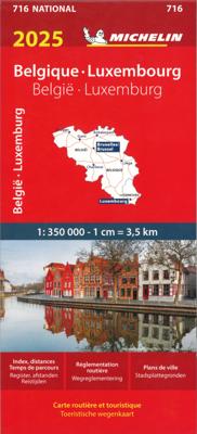
Wegenkaart - landkaart 716 België - Luxemburg 2025 | Michelin

0
Zoals je van Michelin mag verwachten is deze kaart zeer overzichtelijk en heeft een duidelijk helder kaartbeeld. Klassiek en beroemd zijn de groene lijnen langs de aantrekkelijke wegen: zo wordt in een oogopslag duidelijk waar de mooiste plekjes te vinden zijn. De kaart geeft uitgebreid toeristische informatie weer.  Met stadsplattegrond van de ho...

Verkopers met dit product

Verkoper
Bezorging
Prijs
DeZwerver.nl logo
DeZwerver.nl
2,95
11,95

Anderen bekeken ook

Wegenkaart - landkaart 716 België - Luxemburg 2025 | Michelin
Zoals je van Michelin mag verwachten is deze kaart zeer overzichtelijk en heeft een duidelijk helder kaartbeeld. Klassiek en beroemd zijn de groene lijnen langs de aantrekkelijke wegen: zo wordt in een oogopslag duidelijk waar de mooiste plekjes te vinden zijn. De kaart geeft uitgebreid toeristische informatie weer.  Met stadsplattegrond van de hoofdstad.   Belgium and Luxembourg at 1:350,000 from Michelin with information on driving regulations in each country, a distance and journey time table, plus enlargements showing in greater detail road access to Antwerp, Brussels, Liège and Luxembourg City which also has a small plan of its centre.   Roads network includes local roads and is graded according to the number of lanes. Junctions show full or partial interchanges. Steep gradients, level crossings and restricted entry sections are marked; scenic routes are highlighted. Railway lines and ferry routes are included.   Relief shading is used to indicate the topography, with colouring f…
11,95
Wegenkaart - landkaart 717 Gr. H. Luxemburg 2025 | Michelin
Zoals je van Michelin mag verwachten is deze kaart zeer overzichtelijk en heeft een duidelijk helder kaartbeeld. De kaart geeft uitgebreid toeristische informatie weer. Met stadsplattegrond van de hoofdstad.   The Michelin National road map of the Grand Duchy of Luxembourg at 1:150,000 scale is ideal for trip & route planning and touring. The map gives comprehensive coverage of national road networks showing all major motorways, dual carriageways, national & regional main roads and some single-lane roads. Also shows unsurfaced roads, tracks, and major footpaths. The map is divided by grid showing latitude and longitude.   Distances between major locations are marked along roads, with total distance and several intermediate distances shown. A quick-reference chart of distances & driving times between major locations is also included. The map also includes a grid-referenced index of principal place names.   Clear, easy-to read cartography shows roads in reds, yellows and white with blac…
11,95
Wegenkaart - landkaart 795 Benelux 2025 | Michelin
Scheur- en watervast.   Zoals je van Michelin mag verwachten is deze kaart zeer overzichtelijk en heeft een duidelijk helder kaartbeeld. De kaart geeft uitgebreid toeristische informatie weer. Met stadsplattegrond van de hoofdstad.   Grote kracht van de Michelin kaarten is het uitstekende kaartbeeld. Ze maken gebruik van goede kleuren waardoor het zeer leesbaar is. Daarnaast staat er veel informatie op, ook toeristische details en bezienswaardigheden. Erg handig zijn de zogenaamde groene wegen: met een groene lijn geeft Michelin aan welke routes het mooist zijn om te rijden.   Daarnaast wordt een beperkt aantal campings weergegeven, helaas niet allemaal. Meestal betreft het de zgn. camping municipale ofwel de gemeentecampings.   Benelux at 1:400,000 from Michelin, with information on driving regulations in each country, a distance and journey time table, plus enlargements showing in greater detail road access to Amsterdam, Brussels and Luxembourg City. Coverage extends east to include…
12,95
Wegenkaart - landkaart Benelux - Nederland, België en Luxemburg | ITMB
Een degelijke wegenkaart met aanduidingen van o.a. nationale parken, vliegveld, benzinepomp, dirt-roads. Als overzichtskaart goed te gebruiken.   This is a double sided map with Netherlands & Belgium on 1 side. The Belgium portion occupies other shared with Luxembourg. The map has two covers, one side saying Belgium and Luxembourg, with a cover picture of a town square, and the other side says Netherlands and Belgium, with a cover picture of a windmill. The map's artwork is completely new and different from the previous edition, and much more in keeping with ITMB's style for Europe. Motorways are in blue, main roads in green, and other roads in red casing. Road distances between points are noted, as well as motorway rest areas, and touristic sites such as windmills, noteworthy churches, and camping areas. Height elevations are minimal, but park areas have been shown. The border portion of France is also included, as well as appropriate border portions of Germany. The 'Low Countries' a…
13,95
Wegenkaart - landkaart België, Luxemburg | Hallwag
Zeer goede, gedetailleerde en up-to-date autokaart van België en Luxemburg. Met afstandentabel en uitgebreide legenda en index. Hallwag road maps are renowned for their up-to-date information, clear layout and convenience. See for yourself the benefits of the Hallwag international map collection, with new ideas to make travel even easier. The map also covers the north east of France. A range of symbols indicate information for tourists including: places of interests, viewpoints, natural curiosities, notable buildings and ruins, monuments, monasteries and churches, yearly and seasonal campsites, windmills, lighthouses and golf courses. The map includes extensive transportation detail, multiple language information (English, German, Italian, and French), and a complete multiple language index. There are also inset maps showing more detail of the major cities. Relief shading clearly shows the topography of the land. The map also includes Hallwag's Distoguide - the integrated mileage char…
14,50
Wegenkaart - landkaart 718 Duitsland 2025 | Michelin
Zoals je van deze landkaart van Michelin mag verwachten is deze wegenkaart Duitsland zeer overzichtelijk en heeft een duidelijk helder kaartbeeld. De kaart geeft uitgebreid toeristische informatie weer.   Germany at 1:800,000 from Michelin, with information on driving regulations, plus a distance and journey time table. The map is an enlargement of cartography prepared to cover a wider area, so has larger that usual print and greater clarity. Roads network includes local roads and is graded according to the number of lanes. Motorways indicate toll routes and junctions show full or partial interchanges. Toll barriers, steep gradients and seasonal restrictions are marked, scenic routes are highlighted. Railway lines are not included. Relief shading is used to indicate the topography, with colouring for forested areas. Selected regional parks are also marked. Small symbols indicate various landmarks or places of interest, but the map is not designed to highlight tourist sights. The map h…
11,95
Wegenkaart - landkaart 715 Nederland 2025 | Michelin
Zoals je van Michelin mag verwachten is deze kaart zeer overzichtelijk en heeft een duidelijk helder kaartbeeld. De kaart geeft uitgebreid toeristische informatie weer. Met stadsplattegrond van de hoofdstad.   Netherlands at 1:400,000 from Michelin, with information on driving regulations, a distance and journey time table, plus enlargements showing in greater detail road access to Amsterdam, The Hague and Rotterdam with the Europoort and Hoek Van Holland.   Roads network includes local roads and is graded according to the number of lanes. Junctions show full or partial interchanges. Steep gradients (!), level crossings and restricted entry sections are marked; scenic routes are highlighted. Railway lines and ferry routes are included.   Relief shading is used to indicate the topography, with colouring for forested areas. National parks are also marked. Small symbols indicate various landmarks or places of interest including campsites and youth hostels, but the map is not primarily de…
11,95
Reisgids Belgium & Luxembourg - België & Luxemburg | Lonely Planet
De perfecte reisgids voor zowel de georganiseerde als de zelfstandige reiziger. Naast een algemene inleiding van het land / streek vol met praktische informatie over hoe je er het beste kunt reizen: slapen, eten, vervoer, excursies ... alles kun je er in vinden. Engelstalig. Lonely Planet Lonely Planet's local travel experts reveal all you need to know to plan the trip of a lifetime to Belgium & Luxembourg.   Discover popular and off the beaten track experiences from strolling around the Grande Place in Brussels to climbing the belfry in Bruges, and taking a fun-fueled brewery tour at De Koninck in Antwerp.   Build a trip to remember with Lonely Planet's Belgium & Luxembourg travel guide:   Our classic guidebook format provides you with the most comprehensive level of information for planning multi-week trips Updated with an all new structure and design so you can navigate Belgium & Luxembourg and connect experiences together with ease Create your perfect trip with exciting …
24,95
Wegenkaart - landkaart 719 Duitsland, Benelux, Oostenrijk & Tsjechie | Michelin
Zoals je van Michelin mag verwachten is deze kaart zeer overzichtelijk en heeft een duidelijk helder kaartbeeld. De kaart geeft uitgebreid toeristische informatie weer. Met register, afstanden en reistijden. Wegen worden naar verschillende klasse ingedeeld en - mooi van Michelin - de interessante mooie routes worden gemarkeerd met een groene streep.    Hindernissen voor automobilisten met caravans zijn gemarkeerd: steile hellingen, bergpassen of een anderzins moeilijke route. Bezienswaardigheden als een kasteel, religieus gebouw, ruine of grot is door een symbool goed te vinden.   Germany with the Benelux counties, Austria and the Czech Republic on a road map at 1:1,000,000 from Michelin, 2017 edition, with information on driving regulations, a distance and journey time table, and a separate index for each country.   Roads network includes local roads and is graded according to the number of lanes. Motorways indicate toll routes and junctions show full or partial interchanges. Toll ba…
11,95
Reisgids Belgium & Luxembourg - België & Luxemburg | Rough Guides
Zeer goede reisgids voor zowel de georganiseerde maar vooral voor de zelfstandige reiziger. Boordevol informatie over reizen, slapen, eten, maar ook musea en cultuur. Voor Europese landen en steden completer en beter dan de Lonely Planet ! Discover these culture-rich destinations with the most incisive and entertaining guidebook on the market. Whether you plan to go on the beer crawl to end them all, a devoted art pilgrimage - think Ghent's medieval masterpieces and the Magritte connection in Brussels - or an exploration of the Ardennes' wildest reaches, The Rough Guide to Belgium & Luxembourg will show you the ideal places to sleep, eat, drink, shop and visit along the way.Inside The Rough Guide Belgium and Luxembourg- Independent, trusted reviews written with Rough Guides' trademark blend of humour, honesty and insight, to help you get the most out of your visit, with options to suit every budget   .- Full-colour maps throughout - navigate the backstreets of Brussels or the war site…
24,95

Klanten-reviews van Wegenkaart - landkaart 716 België - Luxemburg 2025 | Michelin

Er zijn nog geen beoordelingen voor dit productBen jij de eerste die een review plaatst?

Meer over Wegenkaart - landkaart 716 België - Luxemburg 2025 | Michelin

Productomschrijving

Zoals je van Michelin mag verwachten is deze kaart zeer overzichtelijk en heeft een duidelijk helder kaartbeeld. Klassiek en beroemd zijn de groene lijnen langs de aantrekkelijke wegen: zo wordt in een oogopslag duidelijk waar de mooiste plekjes te vinden zijn. De kaart geeft uitgebreid toeristische informatie weer.  Met stadsplattegrond van de hoofdstad.   Belgium and Luxembourg at 1:350,000 from Michelin with information on driving regulations in each country, a distance and journey time table, plus enlargements showing in greater detail road access to Antwerp, Brussels, Liège and Luxembourg City which also has a small plan of its centre.   Roads network includes local roads and is graded according to the number of lanes. Junctions show full or partial interchanges. Steep gradients, level crossings and restricted entry sections are marked; scenic routes are highlighted. Railway lines and ferry routes are included.   Relief shading is used to indicate the topography, with colouring for forested areas. National parks are also marked. Small symbols indicate various landmarks or places of interest including campsites and youth hostels, but the map is not primarily designed to highlight tourist sights.    The map also indicates locations with street plans in Michelin’s Red Guides to Hotels and Restaurants in Belgium and Luxembourg. Latitude and longitude lines are drawn at 20’ intervals. Multilingual map legend includes English. The index, arranged by country, is next to the map.   Also provided is basic information on each country’s driving regulations, plus a table showing driving distances and journey times between 26 main cities   Anvers, Belgique, Bruges, Bruxelles, Charleroi, Gand, Liège, Luxembourg, Tournai

Productinformatie

    Verken gerelateerde categorieën

    Webshop.nl maakt gebruik van cookies. Ga je verder op onze website, ga dan akkoord met het plaatsen van cookies en de verwerking van deze data door ons en vermelde partners.