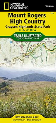
Wandelkaart - Topografische kaart 318 Mount Rogers High Country - Grayson Highlands State Park | National Geographic

0
Prachtige geplastificeerde kaart van het bekende nationaal park. Met alle recreatieve voorzieningen als campsites, maar ook met topografische details en wandelroutes ed. Door uitgekiend kleurgebruik zeer prettig in gebruik. Scheur en watervast!   National Geographic's Trails Illustrated map of Mount Rogers High Country and Grayson Highlands State ...

Verkopers met dit product

Verkoper
Bezorging
Prijs
DeZwerver.nl logo
DeZwerver.nl
2,95
17,95

Anderen bekeken ook

Nieuw
Wandelkaart - Topografische kaart 745 Adirondack Park - Old Forge - Oswegatchie | National Geographic
Prachtige geplastificeerde kaart van het bekende nationaal park. Met alle recreatieve voorzieningen als campsites, maar ook met topografische details en wandelroutes ed. Door uitgekiend kleurgebruik zeer prettig in gebruik. Scheur en watervast! National Geographic's Trails Illustrated map of Adirondack Park Old Forge/Oswegatchie is a two-sided, waterproof, topographic trail map designed to meet the needs of outdoor enthusiasts with unmatched durability and detail. This map was created in cooperation with the Adirondack Mountain Club and is loaded with valuable recreation information, no matter the season. Trails and major roads are clearly distinguished, along with canoe access and snowmobile trails. Places of interest, including the Cranberry Lake 50 Trail, campgrounds, and fishing easements, are labeled and easy to find. The map also features color coded boundaries for parklands, primitive, forest, and private property. Discover the Adirondack's wild, rugged and beautiful terrain, w…
17,95
Nieuw
Wandelkaart - Topografische kaart 744 Adirondack Park - Northville - Raquette Lake | National Geographic
Prachtige geplastificeerde kaart van het bekende nationaal park. Met alle recreatieve voorzieningen als campsites, maar ook met topografische details en wandelroutes ed. Door uitgekiend kleurgebruik zeer prettig in gebruik. Scheur en watervast! National Geographic's Trails Illustrated map of Adirondack Park Northville/Raquette Lake is a two-sided, waterproof, topographic trail map designed to meet the needs of outdoor enthusiasts with unmatched durability and detail. This map was created in cooperation with the Adirondack Mountain Club and is loaded with valuable recreation information for boating, hiking, fishing, sailing, cycling, ice fishing, skiing, and snowmobiling. Trails and major roads are clearly distinguished, from the picturesque foothills to the northern peaks and around lakes of all sizes. Campgrounds, climbing areas, marinas, and museums are labeled and easy to find and boundaries for park lands, wilderness, primitive, forest, and protected areas are clearly marked. Disc…
17,95
Wandelkaart - Topografische kaart 746 Adirondack Park - Saranac - Paul Smiths | National Geographic
Prachtige geplastificeerde kaart van het bekende nationaal park. Met alle recreatieve voorzieningen als campsites, maar ook met topografische details en wandelroutes ed. Door uitgekiend kleurgebruik zeer prettig in gebruik. Scheur en watervast!   National Geographic's Trails Illustrated map of Adirondack Park Saranac/Paul Smiths is a two-sided, waterproof, topographic trail map designed to meet the needs of outdoor enthusiasts with unmatched durability and detail. This map was created in cooperation with the Adirondack Mountain Club and is loaded with valuable recreation information, from the marsh to the forest, alongside lakes and through historic neighborhoods. Trails and major roads are clearly distinguished, along with canoe access and ski areas. Campgrounds, lookout towers, rock climbing, and fishing easements are labeled and easy to find and boundaries for park lands, wilderness, primitive, forest, and protected areas are clearly marked. Discover the Adirondack's wild, rugged a…
17,95
Nieuw
Wandelkaart - Topografische kaart 146 Uncompahgre Plateau South | National Geographic
Prachtige geplastificeerde kaart van het bekende nationaal park. Met alle recreatieve voorzieningen als campsites, maar ook met topografische details en wandelroutes ed. Door uitgekiend kleurgebruik zeer prettig in gebruik. Scheur en watervast!   National Geographic's Trails Illustrated map of Uncompahgre Plateau South is a two-sided, waterproof map designed to meet the needs of outdoor enthusiasts with unmatched durability and detail. This map was created in conjunction with local land management agencies and is loaded with valuable recreation information.   The front side of the map details the southeastern portion of the Plateau and Uncompahgre National Forest, as well as Ridgway State Park. On the reverse side of the map, the southwestern portion of Uncompahgre National Forest, including the Naturita Division, is featured as well as the Tabeguache Area, Roubideau Special Management Area, Unaweep/Tabeguache Scenic and Historic Byway, and Dry Creek Basin and Dan Noble State Wildl…
17,95
Wandelkaart - Topografische kaart 201 Trails Illustrated Yellowstone National Park | National Geographic
Prachtige geplastificeerde kaart van het bekende nationaal park. Met alle recreatieve voorzieningen als campsites, maar ook met topografische details en wandelroutes ed. Door uitgekiend kleurgebruik zeer prettig in gebruik. Scheur en watervast! National Geographic's Trails Illustrated map of Yellowstone National Park is designed to meet the needs of outdoor enthusiasts by combining valuable information with unmatched detail of America's first national park. Expertly researched and created in partnership with local land management agencies, this map features key points of interest including Mammoth Hot Springs, Canyon Village, Yellowstone Lake, Yellowstone Falls, Grant Village, and Old Faithful geyser area.   With over 1,000 miles of mapped trails, the Yellowstone National Park map can guide you off the beaten path and back again. The clearly marked trails include mileages between intersections. Trail summaries provide elevation, duration, and difficulty for a variety of suggested hike…
16,95
Wandelkaart Tour & Trail Corfu - Korfoe | Discovery Walking Guides
Goede wandelkaart van Korfoe. Scheur- en watervast. Corfu Tour & Trail Super-Durable Map is the most detailed, accurate, toughest, large scale map of the island that you can buy. Super-Durable Maps now come with a 2 year adventurous use wear and tear guarantee, see Discovery Walking Guides website for details. Our large 1:40,000 scale produces a double sided map sheet of 840mm by 680mm; big enough to show masses of detail but compact enough to use in the car or on the trail.   Corfu North is on the facing sheet of the map with Corfu South on the reverse side, including a generous overlap between the two sides. Our special concertina map fold means your map is easy to unfold, and more importantly easy to refold back to its pocket size. You get the most detailed map of Corfu that is produced including our 'Tour & Trail' level of detail ranging from major roads to secondary roads to minor roads to streets and narrow country roads, plus dirt roads and walking trails.   We have a new metho…
15,95
Nieuw
Wandelkaart 200 Rocky Mountain National Park | National Geographic
Zeer gedetailleerde wandel- en trekkingkaart voor het Rocky Mountain Nationaal Park in Colorado. Met ingetekende wandelroutes, afstanden, kampeerplekken en toeristische informatie en vele handige tips. GPS geschikt door UTM Grid. Water en scheurvast. Coverage includes Rocky Mountain National Park, Arapaho and Roosevelt National Forest, Never Summer Wilderness, Arapaho National Recreation Area, and the cities of Granby and Estes Park. Revisions to this map include easy-to-read trail mileage and markers, hiking-only and hike and horse trails are easily distinguished, Federal, State and Private lands are clearly marked, the Continental Divide Trail is highlighted, and the map is keyed to the updated Rocky Mountain National Park Dayhiker's Guide. Includes UTM grids for use with your GPS unit.
16,95
Wandelkaart Tour & Trail Madeira | Discovery Walking Guides
Goed gedetallieerde wandelkaart van Madeira, schaal 1:40.000, scheur en watervast papier. Wandelroutes staan ingetekend. Our large 1:40,000 scale, combined with splitting the island into East and West with a generous overlap, produces double sided map whose total size is 840mm by 600mm and folds to 235mm by 120mm. You get the most detailed map of Madeira that is produced including our 'Tour & Trail' level of detail ranging from major roads to secondary roads to minor roads to streets and camino rural narrow country roads, plus dirt roads and walking trails. Altitude background colouring is designed to clearly show the altitude range when travelling across the island by car or on foot. 100 metre and 50 metre contours are clearly shown on the map along with a large number of individual height points and all of the official 'Trig' points. Tour & Trail attention to detail is legendary as is our useful symbol range including miradors, picnic areas, petrol stations, bar/restaurants and park…
15,95
Wandelkaart Tour & Trail Azores - Azoren | Discovery Walking Guides
Gedetailleerde kaart van de Azoren. Met heel veel wandelroutes, al dan niet gemarkeerd. For the best adventures, use the best map. Azores Tour & Trail Super-Durable Map is the most detailed, accurate, toughest, large scale map of these 9 islands that you can buy.    1:60,000 scale for each island, Sao Miguel at 70,000 scale, produces a double sided map sheet of 960mm by 694mm; big enough to show masses of detail but compact enough to use in the car or on the trail. Faial, Pico, Santa Maria and Sao Jorge are on the facing sheet of the map with Corvo, Flores, Graciosa, Sao Miguel and Terceira are on the reverse side. Our special concertina map fold means your map is easy to unfold, and more importantly easy to refold back to its pocket size.   You get the most detailed map of the Azores islands that is produced including our 'Tour & Trail' level of detail ranging from major roads to secondary roads to minor roads to streets and narrow country roads, plus dirt roads and walking trails. W…
15,95
Wandelkaart Tour & Trail La Palma | Discovery Walking Guides
Goede, scheur- en watervaste, wandelkaart van La Palma. Water-proof, split-proof, tear-proof, adventure-proof.  La Palma Tour & Trail Super-Durable Map is simply the toughest, most accurate, easy to read, easy to use map of the island you can buy at any price.  Super-Durable Maps now come with a 2 year adventurous use wear and tear guarantee, see Discovery Walking Guides website for details.    7th Edition of our La Palma Tour & Trail Super-Durable Map is a large 1:40,000 scale map, splitting the island into a North (Landscape view) and South (Portrait view) with a generous overlap, produces double sided map of 840mm by 600mm and folds to 235mm by 120mm. Our legendary 'Tour & Trail' level of detail ranges from major roads to secondary roads to minor roads to streets and camino rural narrow country roads, plus dirt roads and walking trails.  Altitude background colouring is designed to clearly show the altitude range when travelling across the island by car or on foot. 100 metre and 50…
15,95

Klanten-reviews van Wandelkaart - Topografische kaart 318 Mount Rogers High Country - Grayson Highlands State Park | National Geographic

Er zijn nog geen beoordelingen voor dit productBen jij de eerste die een review plaatst?

Meer over Wandelkaart - Topografische kaart 318 Mount Rogers High Country - Grayson Highlands State Park | National Geographic

Productomschrijving

Prachtige geplastificeerde kaart van het bekende nationaal park. Met alle recreatieve voorzieningen als campsites, maar ook met topografische details en wandelroutes ed. Door uitgekiend kleurgebruik zeer prettig in gebruik. Scheur en watervast!   National Geographic's Trails Illustrated map of Mount Rogers High Country and Grayson Highlands State Park, Southwest Virginia, is a two-sided, waterproof, topographic trail map designed to meet the needs of outdoor enthusiasts with unmatched durability and detail. This map was created in cooperation with local land management agencies and is loaded with valuable recreation information for exploring the area's large rock formations, spruce-fir forests, and the highest peak in Virginia. Trails and major roads, including the Appalachian Trail, the Virginia Creeper Trail, and the Virginia Highland Horse Trail, are clearly distinguished. Places of interest include areas for camping, picnicking, fishing, hiking, mountain biking, horseback riding, and cross-country skiing. Boundaries for park lands, wilderness, and protected areas are color coded and easy to discern. The area's unique terrain is the map's core feature, with detailed elevation contours, shaded relief, vegetation, and water features.   Side one features the west side of Mount Rogers, including the Cherokee National Forest and the Beartree Recreation Area. Insets chart the Appalachian Trail profile and list trail ratings, locations, and uses. On the reverse, you'll find the east side of Mount Rogers, including Lewis Fork Wilderness, Little Wilson Creek Wilderness, and the Raccoon Branch Wilderness. Insets list activities available at each of the camps, as well as wilderness area information.   The Mount Rogers High Country map is designed and printed in the United States on durable synthetic paper, making it waterproof, tear-resistant, and trail tough -- capable of going anywhere you do. The map is two-sided, and is folded to a packable size of 4.25" x 9.25"; unfolded size is 26" x 38".   Key Features: • Waterproof and tear-resistant • Updated regularly • Designed and printed in the U.S.A. • Detailed road network, including designations for off-highway roads • Clearly marked trails for hiking, biking, horseback riding, and more • Detailed topography with shaded relief and clearly defined, color-coded boundaries for parks, recreation areas, and wilderness areas. • Hundreds of places-of-interest, including campgrounds, information centers, trailheads, viewpoints, boat launches, fishing access points, waterfalls, and specialty content unique to each area • UTM and Latitude/Longitude coordinate grid, as well as selected waypoints, and a scale bar for easy and accurate navigation.
Webshop.nl maakt gebruik van cookies. Ga je verder op onze website, ga dan akkoord met het plaatsen van cookies en de verwerking van deze data door ons en vermelde partners.