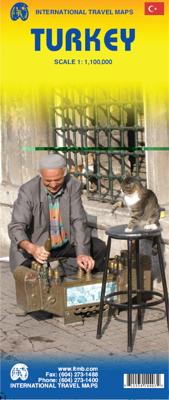
Wegenkaart - landkaart Turkije - Turkey | ITMB

0
Turkey is a fascinating country; so much potential, and seemingly unable to focus on progress as opposed to ideology. Touristically, the country is quite safe, but internal politics are as divided here as in Egypt (and seemingly every Muslim country) between secularists (if it is proper to call them that) who want a 'normal' country with a divisio...

Verkopers met dit product

Verkoper
Bezorging
Prijs
DeZwerver.nl logo
DeZwerver.nl
2,95
13,95

Anderen bekeken ook

Wegenkaart - landkaart West Turkije - Turkey west | ITMB
Turkey is a big country. Most visitors concentrate on Istanbul and the Izmir Coast, which is a shame as there are so many other interesting parts of the country to visit. This map covers the western third of the country as a double-sided map, covering from the Greek/Bulgarian border south to the Mediterranean and east to Eregli and Antalya in the east. Naturally, at a better scale, roads and road conditions can be shown to better advantage, and the ferry routes from Istanbul make more sense. The topography is now showing as contouring more easily, and we have been able to add the next layer of villages. The scale is still not appropriate for showing minor roads and tracks, but we have included as many as we feel we can. The map is printed on durable plastic paper, so will stand up to the rigours of travel quite well. A basin inset map of Istanbul has been included as well.   Legend Includes: Road by classification, Motorways, Multilane Hwy, Main Roads, Rail Ways, Ferry Routes, Nationa…
13,95
Wegenkaart - landkaart Afghanistan | ITMB
Een degelijke kaart met aanduidingen van o.a. nationale parken, vliegveld, benzinepomp, dirt-roads en kleine plattegrond van hoofdstad. Als overzichtskaart goed te gebruiken. Legend Includes: Roads by classification, silk road, airports, towns, villages, ruins, national parks, lakes, swamps, points of interest and other information It is a bit difficult to credit Afghanistan having touristic potential at the moment, but it is an extremely important country right now, and that justifies a very good map of the country. This is our third edition of this country and each one keeps getting better. We can’t justify sending a researcher into a combat zone to gather data, but we are thankful to those aid workers and soldiers who have added to our information base and helped make this map more useful. In this edition, we are showing some new roads, reflecting the reality that the country is succeeding in improving its infrastructure in spite of a very tense political situation. We have also pl…
13,95
Wegenkaart - landkaart Canada | ITMB
Een degelijke kaart met aanduidingen van o.a. nationale parken, vliegveld, benzinepomp, dirt-roads en kleine plattegrond van hoofdstad. Well, it’s about time, eh?!? ITMB, after only thirty years on the go, finally gets around to publishing a map of Canada. When we first started mapping, there was a pressing need for good maps of Central and South America, then of Africa, then etc etc and we never found time to concentrate on our own country until fairly recently. This map was prepared by Natural Resources Canada and is, as a result, as accurate a map as one could hope to have. We are very proud of it, and very pleased to be able to use such top-rate cartography. The map covers all of the land mass of Canada, from its southernmost point to the top of Ellesmere Island and from the Atlantic coast to the Pacific. It’s an excellent map, but I’m going to give one proviso. Canada is the second-largest country on the face of the planet and there is no way that a single-sided sheet can portray…
13,95
Wegenkaart - landkaart Wales & southwest England | ITMB
Een degelijke kaart met aanduidingen van o.a. nationale parken, vliegveld, benzinepompen. Finally, we have been able to create our own map of the lovely country of Wales. I use the word ‘country’ in its truest sense, as Wales was invaded and taken over by the English centuries ago. Regardless, the Welsh language and Welsh culture continue to flourish, although English is commonly spoken. We have visited Wales on several occasions and find that the attractions are so numerous that we could never see them all. There are too many castles to count, but some of the best preserved in the British Isles are in Wales, notable Caernarfon, but nearby Harlech is a World Heritage Site. St, David’s must be one of the smallest and loveliest cathedrals in the world, and Tintern Abbey ruins among the most poignant anywhere. We took Johnny to Abergavenny for lunch in March, not that it made any difference; he just pined for a McDonalds. This map is double-sided, with Wales on one side and the West Coun…
13,95
Wegenkaart - landkaart Egypt & Cairo | ITMB
Following the so-called Arab spring of a few years ago, northern Africa experienced much turbulence. Egypt experienced the overthrow of the government, the installation of a radical religious-oriented replacement, and the installation of military governance. Tourism plummeted. Most map publishers discontinued their maps of the country. Five years later, Egypt has stabilized and tourism is growing. We feel that the time is right to re-introduce our ITMB map of Egypt. This version focuses on the portions of the country that have been re-opened for tourism, which means from the Mediterranean coastline south to the Aswan Dam. The portion further south remains closed for the moment, as is the border crossing with Sudan. We have also been forced to leave off the Great Sand Sea and the Western Desert portions for the same reason of unrest, as the border areas with Libya remain very unstable. However, we have provided a large inset map of Egypt, covering everything, in the area of desert. We …
13,95
Wegenkaart - landkaart 3018 Adventure Map Turkey Turkije | National Geographic
Wegenkaart van Turkije met vermelding van veel bezienswaardigheden, nationale parken en attrakties. Watervast en scheurvast. National Geographic's Turkey Adventure Map is designed to meet the unique needs of adventure travelers with its durability and accurate information. This folded map provides global travelers with the perfect combination of detail and perspective, highlighting hundreds of points of interest and the diverse and unique destinations within the country.   The front side of the Turkey map details the eastern region of the country, from its borders with Syria and Iraq to the south, and with Iran and Armenia to the East, extending to the Black Sea and Georgia to the north. The regions featured on this side are Southeast Anatolia and East Anatolia. The reverse side of the map details Turkey’s western portion of the country, from its border with Greece to the west, to the Mediterranean Sea to the south, extending to the Black Sea to the north. This side covers the Black S…
17,50
Wegenkaart - landkaart Turkmenistan - Afghanistan | ITMB
These two countries, bordering on Iran and Uzbekistan, are in a very volatile part of the world. They constitute the heart of Central Asia; a bit difficult to reach, but definitely suitable for adventure travel. Turkmenistan occupies one side of the sheet, and Afghanistan is on the other side at a better scale. Turkmenistan stretches from the Caspian Sea to a major river (the Amuder) that forms its eastern boundary with Uzbekistan and its border with Afghanistan. An inset map of the capital just north of the Iranian border, Ashgabat, is included. On the other side, Afghanistan is a lovely country and is slowly coming out of an extremely bad situation. It is still quite an unsafe country, and fighting could flare up again in the spring. Regardless, it is a strategically important country and one that ITMB has taken quite a bit of effort to make into a significant map. This is a very interesting map, of an of-the-beaten-track part of the world. It reflects the best information we have, …
13,95
Wegenkaart - landkaart Bahrain & Qatar | ITMB
Een degelijke kaart met aanduidingen van o.a. nationale parken, vliegveld, benzinepomp, dirt-roads en kleine plattegrond van hoofdstad. Als overzichtskaart goed te gebruiken.  Schaal: - Bahrein 1:115.000 - Qatar 1:300.000 The northern portion of the United Arab Emirates consists of a small peninsula (Qatar) and an island (Bahrain). Although these countries are not geographically significant in relation to their neighbours, they are enormously wealthy, thanks to oil, and have aspirations of grandeur. Qatar hosted the FIFA World Cup of soccer in November 2022. This is significant. Qatar, as a destination country, is now 'on the map'. Its capital, Doha, is quite well developed, with three Metro subway lines, motorways, and a sophisticated city centre dominated by superb high-rise architecture. Just to the west, the island of Bahrain is just as wealthy, and just as likely to have ornate architecture, luxurious shopping arcades, and an extravagant lifestyle. Its capital, Manama, is growing…
13,95
Wegenkaart - landkaart Georgia and Tbilisi - Georgië | ITMB
Georgia, the country and not the American state, is a very nice, but threatened country of great historical importance. Bordered on the west by the Black Sea, on the north by Russia, and on the east by Azerbaijan, and with an ill-defined border with Turkey on the west, Georgians must be nimble to retain their independence. Only with neighbouring Armenia does Georgia enjoy relatively good relations. Historically, Georgia is a Christian enclave that dates back to the earliest days of Christianity, and its many churches are major touristic attraction. This map portrays the country as accurately as is possible, showing the expanding network of motorways, major churches, castles, touristic sites, and regrettably, areas of contention with both Russia and Azerbaijan. The reverse side shows a full-sized city map of Tbilisi, the capital. This is the first time that the city has been portrayed in such detail. Attractions include the Narikala Fortress, the cathedral, the old town centre, and the…
13,95
Wegenkaart - landkaart Tel Aviv - Jaffa en Centraal Israel | ITMB
Een kaart die naast het wegennet en plaatsen ook de nadruk legt op de natuurkundige aspecten van het land of gebied. Met kleur worden de verschillende hoogtelagen weergegeven, waardoor je een mooi beeld krijgt van het land. Met symbolen worden bijvoorbeeld benzinepompen aangeduid maar ook stranden. Grote plattegrond Tel Aviv op schaal 1:12.000 Op andere zijde kaart van Centraal Israel op schaal 1:220.000 This map resulted from our visit to Israel a couple of years ago. We got lost in Tel Aviv and wasted a lot of time trying to find our way to where we were staying. Although quite good maps of Tel Aviv exist, most are in Hebrew and are very "Israeli". We decided to do a map that combined the newish city of Tel Aviv with its older and more exotic neighbour, Jaffa, which is currently dominated by those of a non-Jewish orientation. Jaffa is the ancient port used by Phoenicians, Greeks, Romans, and traders plying the Silk Road to China. Its old town is quite compact and a treat to explore.…
13,95

Klanten-reviews van Wegenkaart - landkaart Turkije - Turkey | ITMB

Er zijn nog geen beoordelingen voor dit productBen jij de eerste die een review plaatst?

Meer over Wegenkaart - landkaart Turkije - Turkey | ITMB

Productomschrijving

Turkey is a fascinating country; so much potential, and seemingly unable to focus on progress as opposed to ideology. Touristically, the country is quite safe, but internal politics are as divided here as in Egypt (and seemingly every Muslim country) between secularists (if it is proper to call them that) who want a 'normal' country with a division between secular and religious affairs and those wanting a more traditional religious society where religious values shape the society. Our first edition sold out in a little more than a year, which is pretty amazing in itself, and we have made major improvements to this edition to maintain its popularity. The biggest change is that we have more strongly emphasized the major road network, as most visitors stay on the well-travelled routes around the country, rather than taking back roads to small villages. The second change has been to increase the font size for major urban areas, to make them easier to read. Turkey is a very large country geographically and there is no way cartographically to overcome the spatial relationships of the east-west stretch to the north-south relative shortness. If we have erred, it is on the side of detail, but for anyone driving around the country, such detail is essential.    Legend Includes: Roads by classification, Railways, Feery routes, Dams, Gas stations, Airports, Border crossings, National parks, Churches, church ruins, Monasteries, Mosques, Palaces or castles, Mountain peaks, Monuments, Waterfalls, Caves, Ruins, Campsites, Hotels, Motels, Youth hostels, Viewpoints, Points of interest and much more...

Verken gerelateerde categorieën

Webshop.nl maakt gebruik van cookies. Ga je verder op onze website, ga dan akkoord met het plaatsen van cookies en de verwerking van deze data door ons en vermelde partners.