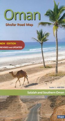
Wegenkaart - landkaart Oman - Dhofar Road Map | Hupe Verlag

0
Actuele, gedetailleerde wegenkaart van het zuiden van Oman en stadsplattegrond van Salalah. Tweetalig Engels/Duits, met GPS coördinaten. Wegenkaart van Dhofar: schaal 1 : 600 000 Kaart van het kustgebied: schaal 1 : 305 000 Stadsplattegrond van Salalah: 1 : 40 000...

Verkopers met dit product

Verkoper
Bezorging
Prijs

Anderen bekeken ook

Wegenkaart - landkaart 2 India - West | Nelles Verlag
Goede kaart van een deel van India. Aan beide kanten bedrukt. Met veel toeristische aanduidingen als nationale parken en culturele bezienswaardigheden. Prima leesbare kaart. Detailkaart: Mumbai (Bombay) 1 : 300.000 Stadsplattegrond: Delhi 1 : 50.000 one of five maps in a series covering India at 1:1 500 000 scale. Folded road and tourist map of western India, including edge of Pakistan to the west, Chandigarh to the north, Pune to the south and Bhopal and Delhi to the east. Points of interest, national parks, and railways are all highlighted and shaded-relief colouring clearly depicts the topography.  The map includes insets showing central Delhi at 1:50 000 and Mumbai (Bombay) region at 1:300 000. The legend is in English, French and German. The other titles in the series are India East, India North, India North East, and India South. Nelles also produces a map of the whole Indian Subcontinent at a scale of 1:4 500 000.   For over 20 years Nelles maps have been renowned throughout th…
11,95
Wegenkaart - landkaart Muscat / Oman | ITMB
The very name Muscat and Oman entices one! The peninsula at the access point to the Persian/Arabian Gulf sounds very exotic – and it is! This double-sided map focuses on the city and region of Muscat on side one at a detailed scale, noting the Grand Mosque, the Mutrah Souk, and the Royal Opera House as well as showing hotels, shopping areas, and other sites of touristic interest. Muscat used to be a British protectorate, but is now part of Oman, albeit physically separated from it by a portion of the UAE. The country fills side 2. Oman is portrayed as a north-south alignment, as it is long and not particularly wide, and nicely fills the sheet, with an inset of Salalah, close to the Yemeni border. Connections to nearby Abu Dhabi and Dubai are also shown. Oman is a haven of peaceful co-existence, and tourists are welcome, so this map is designed to encourage visitors  
13,95
Wegenkaart - landkaart Oman & Yemen - Jemen | ITMB
Een degelijke kaart met aanduidingen van o.a. nationale parken, vliegveld, benzinepomp, dirt-roads en kleine plattegrond van hoofdstad. Als overzichtskaart goed te gebruiken.    We were in Oman a couple of weeks before year end and can certify that it is a safe and attractive country to visit; completely different from its neighbours. The main city is Muscat, which has an inset map on the country side of the sheet, as well as a map of Salalah, in the far west of the country. The road network of the country is well developed, with several crossings to the UAE. Unfortunately, none are available to Saudi Arabia, and the crossing to Yemen, while open, is not advised, due to on-going fighting. Oman also has two enclaves surrounded by UAE; a small one north of Fujairah, and another at the northern tip of the peninsula, separating the Gulf of Oman from the Persian (or Arabic) Gulf. Oman has a long history and an interesting culture, and is well worth a visit. The other side of the sheet con…
13,95
Wegenkaart - landkaart Zanzibar - The spice island | Harms IC Verlag
 Gedetailleerde toeristenkaart, wegenkaart van Zanzibar met stadsplattegrond Stone Town en een kaart van Pemba. De kaart is geschikt voor gebruik met GPS. Im Maßstab 1:100.000 zeigt die Karte in detaillierter Darstellung die gesamte Region der berühmten Gewürzinsel „Sansibar“, einschließlich der Korallengärten und der vorgelagerten Inselwelt. Ergänzend enthält sie eine Karte der Insel Pemba im Maßstab 1:250.000, einen Stadtplan von Stone Town im Maßstab 1:10.000, dem historischen Zentrum der Hauptstadt und eine Übersichtskarte der Region. Zahlreiche Symbole verweisen auf Sehenswürdigkeiten, Hotels und Beach Resorts. Sämtliche Straßen, Pisten und touristisch interessanten Karteninhalte wurden mit GPS aufgenommen. Die Karte entstand in Zusammenarbeit mit den tansanischen Behörden und dem Institute of Marine Sciences, der Universität von Dar es Salaam.   Die Kartenrückseite bietet nützliche Reiseinformationen in drei Sprachen (Deutsch, Englisch und Italienisch) und gibt u.a. Auskunft übe…
10,95
Wegenkaart - landkaart Oman | Reise Know-How Verlag
Tweetalige kaart (Engels en Duits). Door ingetekende lengte- en breedtegraden is het gebruik van GPS mogelijk. Met hoogtelijnen en uitgebreid wegennetwerk: daarnaast worden ook de afstanden tussen belangrijke plaatsen duidelijk leesbaar weergegeven. Het kleurgebruik is zodanig dat je een goede indruk krijgt van hoogteverschillen en soorten landschap. Natuurlijk staan de toeristische bezienswaardigheden duidelijk vermeld.   Gedrukt op water- en scheurvast papier! Polyart is een synthetisch product vrij van giftige stoffen dus duurzaam. Het papier gaat echt lang mee.   Topography is indicated by altitude colouring with numerous spot heights and names of mountain ranges and passes. Salt lakes, swamps, seasonal rivers and glacier are also shown. Detailed presentation of the road network includes minor roads and tracks and railways are also shown.   Internal administrative units are presented with their boundaries and names. National parks and other protected areas are highlighted. A wide …
15,95
Wegenkaart - landkaart - Fietskaart - Stadsplattegrond 88412 Strasbourg | IGN - Institut Géographique National
Goede gedetailleerde kaart van Straatsburg en grote omgeving. Let op: het is geen stadsplattegrond, maar een wegenkaart van de stad en de directe omgeving op een schaal van 1:80.000: ideaal voor kleine uitstapjes of fietstochten. Slechts een kleine extra inzet met het centrum staat er op als stadsplattegrond.    Ultra-lisibles et de grande précision, les cartes « Une ville et ses environs » vous permettront de planifier vos déplacements professionnels ou personnels et de pratiquer vos loisirs préférés à l’aide de 3 échelles différentes adaptées à vos besoins : de la carte générale (1 : 80 000) au plan de ville (Variable selon cartes. Principalement 1 : 13 000) en passant par un extrait de carte IGN TOP 25 (1 : 30 000) pour pratiquer la randonnée ou une carte touristique pour découvrir des sites d’exception. Dimensions : 110 cm x 75 cm
7,95

Klanten-reviews van Wegenkaart - landkaart Oman - Dhofar Road Map | Hupe Verlag

Er zijn nog geen beoordelingen voor dit productBen jij de eerste die een review plaatst?

Meer over Wegenkaart - landkaart Oman - Dhofar Road Map | Hupe Verlag

Productomschrijving

Actuele, gedetailleerde wegenkaart van het zuiden van Oman en stadsplattegrond van Salalah. Tweetalig Engels/Duits, met GPS coördinaten.

Wegenkaart van Dhofar: schaal 1 : 600 000
Kaart van het kustgebied: schaal 1 : 305 000
Stadsplattegrond van Salalah: 1 : 40 000

Productinformatie

    Verken gerelateerde categorieën

    Webshop.nl maakt gebruik van cookies. Ga je verder op onze website, ga dan akkoord met het plaatsen van cookies en de verwerking van deze data door ons en vermelde partners.