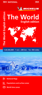
Wegenkaart - landkaart 701 The world - Wereld | Michelin

0
De gevouwen Wereldkaart van Michelin: ideaal voor een snel overzicht waar alle landen liggen, de hoofdsteden en verbindingen. The WorldMichelin Map is perfect for route planning as well as excellent road detail and classification and clearly show the regions topography. Included in this map are national flags, population and surface areas and worl...

Verkopers met dit product

Verkoper
Bezorging
Prijs
DeZwerver.nl logo
DeZwerver.nl
2,95
12,95

Anderen bekeken ook

Nieuw
Wegenkaart - landkaart 738 Roemenië - Roemenie | Michelin
Zoals je van Michelin mag verwachten is deze kaart zeer overzichtelijk en heeft een duidelijk helder kaartbeeld. De kaart geeft uitgebreid toeristische informatie weer. Met register, afstanden en reistijden. Wegen worden naar verschillende klasse ingedeeld en - mooi van Michelin - de interessante mooie routes worden gemarkeerd met een groene streep.    Hindernissen voor automobilisten met caravans zijn gemarkeerd: steile hellingen, bergpassen of een anderzins moeilijke route. Bezienswaardigheden als een kasteel, religieus gebouw, ruine of grot is door een symbool goed te vinden.   The Michelin national road map of Romania at 1:750,000 scale is best suited to trip & route planning. The map gives comprehensive coverage of national road networks showing major motorways, dual carriageways, national & regional main roads and some smaller local roads. Unsurfaced roads and tracks and some major footpaths are also shown. The map shows useful motoring information for motorways and major roads …
11,95
Nieuw
Wegenkaart - landkaart 743 Algerije - Tunesië | Michelin
Kaart van beroemde kaartenmakers en voor Algerije en Tunesie weer een hele goede. Uitermate goed leesbaar, prettig kleurgebruik. Zoals je van Michelin mag verwachten is deze kaart zeer overzichtelijk en heeft een duidelijk helder kaartbeeld. De kaart geeft uitgebreid toeristische informatie weer. Met register, afstanden en reistijden. Wegen worden naar verschillende klasse ingedeeld en - mooi van Michelin - de interessante mooie routes worden gemarkeerd met een groene streep.    Hindernissen voor automobilisten met caravans zijn gemarkeerd: steile hellingen, bergpassen of een anderzins moeilijke route. Bezienswaardigheden als een kasteel, religieus gebouw, ruine of grot is door een symbool goed te vinden. The Michelin National road map of Algeria & Tunisia at 1:1,000,000 scale is ideal for trip & route planning. The map gives comprehensive coverage of national road networks showing all major motorways, dual carriageways, national & regional main roads and some local roads. Also shows …
12,95
Nieuw
Wegenkaart - landkaart 736 Slovenie, Kroatie, Bosnie-Herzegowina, Servie, Montenegro, Macedonie | Michelin
Zoals je van Michelin mag verwachten is deze kaart zeer overzichtelijk en heeft een duidelijk helder kaartbeeld. De kaart geeft uitgebreid toeristische informatie weer. Met register, afstanden en reistijden. Wegen worden naar verschillende klasse ingedeeld en - mooi van Michelin - de interessante mooie routes worden gemarkeerd met een groene streep.    Hindernissen voor automobilisten met caravans zijn gemarkeerd: steile hellingen, bergpassen of een anderzins moeilijke route. Bezienswaardigheden als een kasteel, religieus gebouw, ruine of grot is door een symbool goed te vinden. Goede overzichtskaart van de Balkan landen. The Michelin National road map of Slovenia, Croatia, Bosnia and Herzegovina, Serbia, Montenegro and the Republic of Macedonia; at 1:1,000,000 scale it is ideal for route. The map gives comprehensive coverage of national road networks showing all major motorways, dual carriageways, national & regional main roads and some single-lane roads. Also shows unsurfaced roads …
11,95
Nieuw
Wegenkaart - landkaart 02 Canadian Rockies Banff & Jasper | Gem Trek Maps
Goede wegenkaart van Banff & Jasper met bezienswaardigheden, Overnachtingsmogelijkheden, Campings en hete bronnen. This is our most popular driving (touring) map and the map most recommended as an overview for anyone planning a trip to the Canadian Rocky Mountain Parks - Banff, Jasper, Yoho and Kootenay. It also covers Mount Revelstoke and Glacier national parks, the Bugaboos and the Purcell Mountains further west.  29 of the best points of interest in the Rocky Mountain Parks are numbered and described. Mountain lodges, campgrounds, hostels, hot springs, golf courses, ski areas, picnic sites, visitor centres and highway viewpoints are labelled. The mountains are also labelled with their name and elevation, if available, and glaciers are easy to pick out because they are shown in a different colour.  On the back, you will find a map of Western Canada showing all the major highways, as well as maps showing the major arteries in the cities of Edmonton and Calgary. There are also town ma…
13,95
Nieuw
Wegenkaart - landkaart 755 Tsjechië | Michelin
Zoals je van Michelin mag verwachten is deze kaart zeer overzichtelijk en heeft een duidelijk helder kaartbeeld. De kaart geeft uitgebreid toeristische informatie weer. Met register, afstanden en reistijden. Wegen worden naar verschillende klasse ingedeeld en - mooi van Michelin - de interessante mooie routes worden gemarkeerd met een groene streep. Hindernissen voor automobilsiten met caravans zijn gemarkeerd: steile hellingen, bergpassen of een anderzins moeilijke route. Bezienswaardigheden als een kasteel, religieus gebouw, ruine of grot is door een symbool goed te vinden.   The Michelin National road map of the Czech Republic at 1:450,000 scale is ideal for route planning and touring. The map gives comprehensive coverage of national road networks showing all major motorways, dual carriageways, national & regional main roads and most single-lane roads. The map is divided by grid showing latitude and logitude.   Distances between major locations are marked along roads, with total di…
11,95
Wegenkaart - landkaart 3203 Adventure Map Morocco - Marokko | National Geographic
Wegenkaart van Marokko met vermelding van veel bezienswaardigheden, nationale parken en attrakties. Watervast en scheurvast. Juist door deze vermeldingen onderscheidt de kaart zich van andere wegenkaarten. National Geographic's Morocco Adventure Map is designed to meet the unique needs of adventure travelers—detailed, durable, and accurate. Morocco includes the locations of thousands of cities and towns with an index for easily locating them, plus a clearly marked road network complete with distances and designations for motorways, dual carriageways, major roadways, and more. Transportation within and beyond the country is made easier with the location of airports, airfields, railroads, ferry routes, river crossings, lighthouses, harbors, border crossings, and petrol stations. What sets National Geographic Adventure Maps apart from traditional road maps are the hundreds of points of interest that highlight the diverse, unique, and exotic destinations within Morocco. In addition to typ…
17,50
Nieuw
Wegenkaart - landkaart 754 Finland | Michelin
Zoals je van Michelin mag verwachten is deze kaart zeer overzichtelijk en heeft een duidelijk helder kaartbeeld. De kaart geeft uitgebreid toeristische informatie weer. Met register, afstanden en reistijden.   Wegen worden naar verschillende klasse ingedeeld en - mooi van Michelin - de interessante mooie routes worden gemarkeerd met een groene streep. Hindernissen voor automobilsiten met caravans zijn gemarkeerd: steile hellingen, bergpassen of een anderzins moeilijke route. Bezienswaardigheden als een kasteel, religieus gebouw, ruine of grot is door een symbool goed te vinden.   The Michelin National road map of Finland at 1:1,250,000 scale is ideal for route planning. The map gives comprehensive coverage of national road networks showing all major motorways, dual carriageways, national & regional main roads and some single-lane roads. Also shows unsurfaced roads. The map is divided by grid showing latitude and longitude.   Distances between major locations are marked along roads, wi…
11,95
Nieuw
Wegenkaart - landkaart 04 Southwest British Columbia & Northern Washington | Gem Trek Maps
Goede wegenkaart van British Columbia met Nationale Parken, Overnachtingsmogelijkheden, Ski gebieden en bezienswaardigheden. Gem Trek’s Southwest British Columbia & Northern Washington map meets the needs of visitors looking to explore the lower mainland of British Columbia and the northern section of Washington state.   All the major highways are shown, as well as national, provincial, and state parks and wilderness areas. The map also shows lesser-known back roads, and pinpoints the location of lodges, campgrounds and hot springs. Mileage charts on the front and back provide distances between major towns and cities.   The Southwest British Columbia & Northern Washington map covers all of Vancouver Island and extends west through the city of Vancouver and the Okanagan Valley to the Kootenays. South of the border, Washington state is covered from the Gulf Islands in the west to Spokane in the east, with coverage as far south as Mount Rainer National Park.   The Southwest British Colu…
9,95
Nieuw
Wegenkaart - landkaart 720 Polen | Michelin
Zoals je van Michelin mag verwachten is deze kaart zeer overzichtelijk en heeft een duidelijk helder kaartbeeld. De kaart geeft uitgebreid toeristische informatie weer. Met stadsplattegrond van de hoofdstad. The Michelin National road map of Poland at 1:700,000 scale is ideal for route planning. The map gives comprehensive coverage of national road networks showing all major motorways, dual carriageways, national & regional main roads and some single-lane roads. Distances between major locations are marked along roads, with total distance and several intermediate distances shown. A quick-reference chart of distances & driving times between major locations is also included. The map also includes a grid-referenced index of principal place names.   Clear, easy-to read cartography shows roads in reds, yellows and white with black outlines. Major topography is indicated with relief shading. Woodland & forest is marked with green shading. Built-up urban areas are clearly marked in yellow. A…
11,95
Nieuw
Wegenkaart - landkaart Benelux - Nederland, België en Luxemburg | ITMB
Een degelijke wegenkaart met aanduidingen van o.a. nationale parken, vliegveld, benzinepomp, dirt-roads. Als overzichtskaart goed te gebruiken.   This is a double sided map with Netherlands & Belgium on 1 side. The Belgium portion occupies other shared with Luxembourg. The map has two covers, one side saying Belgium and Luxembourg, with a cover picture of a town square, and the other side says Netherlands and Belgium, with a cover picture of a windmill. The map's artwork is completely new and different from the previous edition, and much more in keeping with ITMB's style for Europe. Motorways are in blue, main roads in green, and other roads in red casing. Road distances between points are noted, as well as motorway rest areas, and touristic sites such as windmills, noteworthy churches, and camping areas. Height elevations are minimal, but park areas have been shown. The border portion of France is also included, as well as appropriate border portions of Germany. The 'Low Countries' a…
13,95

Klanten-reviews van Wegenkaart - landkaart 701 The world - Wereld | Michelin

Er zijn nog geen beoordelingen voor dit productBen jij de eerste die een review plaatst?

Meer over Wegenkaart - landkaart 701 The world - Wereld | Michelin

Productomschrijving

De gevouwen Wereldkaart van Michelin: ideaal voor een snel overzicht waar alle landen liggen, de hoofdsteden en verbindingen.

The WorldMichelin Map is perfect for route planning as well as excellent road detail and classification and clearly show the regions topography.

Included in this map are national flags, population and surface areas and world time zones. The North Pole and the South Pole are shown as insets on this map. Main roads are well classified, as well as international boundaries, capitol and major cities as well as transcontinental railway systems   The map also features a reasonably comprehensive climate chart giving min and max temperatures and average monthly rainfall for major world cities. Also shown are mountains and ocean depths in certain areas.

Verken gerelateerde categorieën

Webshop.nl maakt gebruik van cookies. Ga je verder op onze website, ga dan akkoord met het plaatsen van cookies en de verwerking van deze data door ons en vermelde partners.