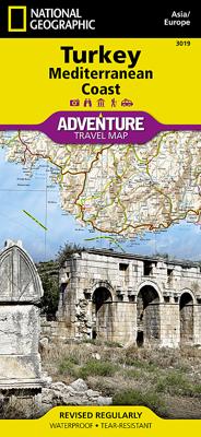
Wegenkaart - landkaart 3019 Adventure Map Turkey Mediterranean Coast Turkije | National Geographic

0
Wegenkaart van de zuidelijke kust van Turkije met vermelding van veel bezienswaardigheden, nationale parken en attrakties. Watervast en scheurvast.   National Geographic's Turkey, Mediterranean Coast Adventure Map is designed to meet the unique needs of adventure travelers with its durability and accurate information. This folded map provides glob...

Verkopers met dit product

Verkoper
Bezorging
Prijs
DeZwerver.nl logo
DeZwerver.nl
2,95
17,50

Anderen bekeken ook

Wegenkaart - landkaart 3019 Adventure Map Turkey Mediterranean Coast Turkije | National Geographic
Wegenkaart van de zuidelijke kust van Turkije met vermelding van veel bezienswaardigheden, nationale parken en attrakties. Watervast en scheurvast.   National Geographic's Turkey, Mediterranean Coast Adventure Map is designed to meet the unique needs of adventure travelers with its durability and accurate information. This folded map provides global travelers with the perfect combination of detail and perspective, highlighting hundreds of points of interest and the diverse and unique destinations within the country.   The front side of the Turkey Mediterranean Coast map details the southern coastal region of the country. This side shows the Mediterranean Sea to the south and Syria to the east. The coastline extends from Kas to Iskenderum. The reverse side of the map details Turkey’s western coastal region of the country and its border with Greece and Bulgaria. This side shows the western coast from the Sea of Marmara down to the Mediterranean Sea. The map includes the locations of cit…
17,50
Wegenkaart - landkaart 3018 Adventure Map Turkey Turkije | National Geographic
Wegenkaart van Turkije met vermelding van veel bezienswaardigheden, nationale parken en attrakties. Watervast en scheurvast. National Geographic's Turkey Adventure Map is designed to meet the unique needs of adventure travelers with its durability and accurate information. This folded map provides global travelers with the perfect combination of detail and perspective, highlighting hundreds of points of interest and the diverse and unique destinations within the country.   The front side of the Turkey map details the eastern region of the country, from its borders with Syria and Iraq to the south, and with Iran and Armenia to the East, extending to the Black Sea and Georgia to the north. The regions featured on this side are Southeast Anatolia and East Anatolia. The reverse side of the map details Turkey’s western portion of the country, from its border with Greece to the west, to the Mediterranean Sea to the south, extending to the Black Sea to the north. This side covers the Black S…
17,50
Wegenkaart - landkaart 3208 Adventure Map Israel | National Geographic
Wegenkaart van Isreal met vermelding van veel bezienswaardigheden, nationale parken en attrakties. Watervast en scheurvast. Juist door deze vermeldingen onderscheidt de kaart zich van andere wegenkaarten. National Geographic's Israel Adventure Map is designed to meet the unique needs of adventure travelers with its durability and accurate information. This folded map provides global travelers with the perfect combination of detail and perspective, highlighting hundreds of points of interest and the diverse and unique destinations within the country.   The map includes the locations of cities and towns with a user-friendly index, plus a clearly marked road network complete with distances and designations for major highways, main roads, and tracks and trails for those seeking to explore more remote regions. The front side of the Israel map details the northern region of the country, from its border with Lebanon to the north, to Syria and Jordan to the east and the Mediterranean Sea to t…
17,50
Wegenkaart - landkaart 3202 Adventure Map Egypt - Egypte | National Geographic
Wegenkaart van Egypte met vermelding van veel bezienswaardigheden, nationale parken en attrakties. Watervast en scheurvast. Juist door deze vermeldingen onderscheidt de kaart zich van andere wegenkaarten. National Geographic's Egypt Adventure Map is designed to meet the unique needs of adventure travelers with its detail, durability, and accuracy. The map includes the locations of thousands of cities and towns with an index for easily locating them, plus a clearly marked road network complete with distances and designations for expressways, major roadways, and more. Transportation within and beyond the country is made easier with the locations of airports, airfields, railroads, ferry routes, lighthouses, harbors, border crossings, and police control points.   What sets National Geographic Adventure Maps apart from traditional road maps are the hundreds of points of interest that highlight the diverse, unique, and exotic destinations within Egypt. In addition to typical sites of intere…
17,50
Wegenkaart - landkaart 3315 Adventure Map Corsica | National Geographic
Wegenkaart van Corsica met vermelding van veel bezienswaardigheden, nationale parken en attrakties. Watervast en scheurvast. Juist door deze vermeldingen onderscheidt de kaart zich van andere wegenkaarten. National Geographic's Corsica Adventure Map is designed to meet the unique needs of adventure travelers with its durability and accurate information. Each folded map provides global travelers with the perfect combination of detail and perspective, highlighting the area’s terrain and best locations for adventure activities like snorkeling, surfing, fishing, and more. Adventure Maps include hundreds of points of interest that highlight diverse and unique destinations within the country.   The map includes the locations of thousands of cities and towns with a user-friendly index, plus a clearly marked road network complete with distances and designations for major highways, main roads, and tracks and trails for those seeking to explore more remote regions. The front side of the Corsica…
17,50
Wegenkaart - landkaart Spain Mediterranean Coast | ITMB
Een degelijke overzichtskaart van het oosten en zuiden van Spanje. Spain is one of the most popular travel destinations in Europe. The country is extremely diverse, reflecting its history. The coastal areas of the Mediterranean were probably first settled by Phoenicians, then Greeks, then Romans, and then Arabs before being brought into a united Spain at the time Columbus was seeking a sponsor to fund his proposed journey to discover new lands to the west. This map focuses on the coast from the French border south through Catalunya all the way to the Straits of Gibraltar and Cadiz. The offshore islands of Mallorca, Ibiza, and Menorca are included, as is the North African Spanish enclave of Ceuta and the British enclave of Gibraltar. All road and rail lines are shown, including the new Cadiz to Madrid fast train. By the nature of mapping, a considerable amount of the interior is on the map as well, so this map is much more than just a coastal journey through Valencia and Murcia to reac…
13,95
Wegenkaart - landkaart West Turkije - Turkey west | ITMB
Turkey is a big country. Most visitors concentrate on Istanbul and the Izmir Coast, which is a shame as there are so many other interesting parts of the country to visit. This map covers the western third of the country as a double-sided map, covering from the Greek/Bulgarian border south to the Mediterranean and east to Eregli and Antalya in the east. Naturally, at a better scale, roads and road conditions can be shown to better advantage, and the ferry routes from Istanbul make more sense. The topography is now showing as contouring more easily, and we have been able to add the next layer of villages. The scale is still not appropriate for showing minor roads and tracks, but we have included as many as we feel we can. The map is printed on durable plastic paper, so will stand up to the rigours of travel quite well. A basin inset map of Istanbul has been included as well.   Legend Includes: Road by classification, Motorways, Multilane Hwy, Main Roads, Rail Ways, Ferry Routes, Nationa…
13,95
Wegenkaart - landkaart 3317 Adventure Map Crete - Kreta | National Geographic
Wegenkaart van Kreta met vermelding van veel bezienswaardigheden, nationale parken en attrakties. Watervast en scheurvast. Juist door deze vermeldingen onderscheidt de kaart zich van andere wegenkaarten.   National Geographic's Crete Adventure Map is designed to meet the unique needs of adventure travelers with its durability and accurate information. This folded map provides global travelers with the perfect combination of detail and perspective, highlighting hundreds of points of interest and the diverse and unique destinations within the country.   The front side of the Crete map details the eastern region of the island with the Sea of Crete to the north. The reverse side of the map shows the western region of the island with the Aegean Sea to the north and the Mediterranean Sea to the south. The map includes the locations of cities and towns with a user-friendly index, plus a clearly marked road network complete with distances and designations for major highways, main roads, and t…
17,50
Wegenkaart - landkaart 3203 Adventure Map Morocco - Marokko | National Geographic
Wegenkaart van Marokko met vermelding van veel bezienswaardigheden, nationale parken en attrakties. Watervast en scheurvast. Juist door deze vermeldingen onderscheidt de kaart zich van andere wegenkaarten. National Geographic's Morocco Adventure Map is designed to meet the unique needs of adventure travelers—detailed, durable, and accurate. Morocco includes the locations of thousands of cities and towns with an index for easily locating them, plus a clearly marked road network complete with distances and designations for motorways, dual carriageways, major roadways, and more. Transportation within and beyond the country is made easier with the location of airports, airfields, railroads, ferry routes, river crossings, lighthouses, harbors, border crossings, and petrol stations. What sets National Geographic Adventure Maps apart from traditional road maps are the hundreds of points of interest that highlight the diverse, unique, and exotic destinations within Morocco. In addition to typ…
17,50
Wegenkaart - landkaart 3304 Adventure Map Italy - Italië | National Geographic
Wegenkaart van Italië met vermelding van veel bezienswaardigheden, nationale parken en attrakties. Watervast en scheurvast. Juist door deze vermeldingen onderscheidt de kaart zich van andere wegenkaarten.   National Geographic's Italy Adventure Map is designed to meet the unique needs of adventure travelers—detailed, durable, and accurate. Italy includes the locations of thousands of major cities and towns with an index for easily locating them, plus a clearly marked road network complete with distances and designations for expressways, motorways, and more.   What sets National Geographic Adventure Maps apart from traditional road maps are the hundreds of points of interest that highlight the diverse and unique destinations within Italy. National parks, World Heritage sites, caves, scenic viewpoints, archeological sites, castles, palaces, churches, monasteries, and museums are included, making it invaluable to travelers hoping to experience all the history, art, and culture this amazi…
17,50

Klanten-reviews van Wegenkaart - landkaart 3019 Adventure Map Turkey Mediterranean Coast Turkije | National Geographic

Er zijn nog geen beoordelingen voor dit productBen jij de eerste die een review plaatst?

Meer over Wegenkaart - landkaart 3019 Adventure Map Turkey Mediterranean Coast Turkije | National Geographic

Productomschrijving

Wegenkaart van de zuidelijke kust van Turkije met vermelding van veel bezienswaardigheden, nationale parken en attrakties. Watervast en scheurvast.   National Geographic's Turkey, Mediterranean Coast Adventure Map is designed to meet the unique needs of adventure travelers with its durability and accurate information. This folded map provides global travelers with the perfect combination of detail and perspective, highlighting hundreds of points of interest and the diverse and unique destinations within the country.   The front side of the Turkey Mediterranean Coast map details the southern coastal region of the country. This side shows the Mediterranean Sea to the south and Syria to the east. The coastline extends from Kas to Iskenderum. The reverse side of the map details Turkey’s western coastal region of the country and its border with Greece and Bulgaria. This side shows the western coast from the Sea of Marmara down to the Mediterranean Sea. The map includes the locations of cities and towns with a user-friendly index, plus a clearly marked road network complete with distances and designations for major highways, main roads, and tracks and trails for those seeking to explore more remote regions. Every Adventure Map is printed on durable synthetic paper, making them waterproof, tear-resistant and tough—capable of withstanding the rigors of international travel.   Key Features:
  • Waterproof and tear-resistant
  • Detailed interpretive information and local travel tips
  • Detailed topography complete with activity symbols, ideal for exploring the country
  • City overview maps
  • Hundreds of points of interest, including the location of World Heritage sites, national parks and nature reserves, aboriginal settlements and protected lands, mines, archeological sites, wildlife parks and more
  • Thousands of place names
  • Important travel aids including airports, lighthouses, ferry routes and rail lines
  • Developed in cooperation with local agencies
  • Updated regularly to ensure accuracy

Productinformatie

    Verken gerelateerde categorieën

    Webshop.nl maakt gebruik van cookies. Ga je verder op onze website, ga dan akkoord met het plaatsen van cookies en de verwerking van deze data door ons en vermelde partners.