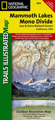
Wandelkaart - Topografische kaart 809 Mammoth Lakes - Mono Divide - Inyo and Sierra National Forests | National Geographic

0
Prachtige geplastificeerde kaart van het bekende nationaal park. Met alle recreatieve voorzieningen als campsites, maar ook met topografische details en wandelroutes ed. Door uitgekiend kleurgebruik zeer prettig in gebruik. Scheur en watervast! Trails Illustrated Mammoth Lakes / Mono Divide is the first of five exciting new maps for the California...

Verkopers met dit product

Verkoper
Bezorging
Prijs
DeZwerver.nl logo
DeZwerver.nl
2,95
17,95

Anderen bekeken ook

Wandelkaart - Topografische kaart 201 Trails Illustrated Yellowstone National Park | National Geographic
Prachtige geplastificeerde kaart van het bekende nationaal park. Met alle recreatieve voorzieningen als campsites, maar ook met topografische details en wandelroutes ed. Door uitgekiend kleurgebruik zeer prettig in gebruik. Scheur en watervast! National Geographic's Trails Illustrated map of Yellowstone National Park is designed to meet the needs of outdoor enthusiasts by combining valuable information with unmatched detail of America's first national park. Expertly researched and created in partnership with local land management agencies, this map features key points of interest including Mammoth Hot Springs, Canyon Village, Yellowstone Lake, Yellowstone Falls, Grant Village, and Old Faithful geyser area.   With over 1,000 miles of mapped trails, the Yellowstone National Park map can guide you off the beaten path and back again. The clearly marked trails include mileages between intersections. Trail summaries provide elevation, duration, and difficulty for a variety of suggested hike…
16,95
Nieuw
Wandelkaart - Topografische kaart 314 Many Glacier - Glacier and Waterton Lakes National Parks | National Geographic
Prachtige geplastificeerde kaart van het bekende nationaal park. Met alle recreatieve voorzieningen als campsites, maar ook met topografische details en wandelroutes ed. Door uitgekiend kleurgebruik zeer prettig in gebruik. Scheur en watervast!   Located just north of Kalispell in Montana's northwest corner, Glacier National contains an abundance of recreational opportunities for outdoor enthusiasts of all interests.   This detailed topographic recreation map contains carefully researched trails, campsites, forest service roads, and points-of-interests, for the Many Glacier section of the park. Two additional maps for the North Fork and the Two Medicine regions of the park along with a comprehensive Glacier National Park Trails Illustrated map are also available. An enhanced scale of 1:50,000, useful UTM and Latitude/Longitude grids, mileage charts, and other navigation features make the North Fork sectional the best map available for the western side of the park.   The North Side of …
14,95
Nieuw
Wandelkaart - Topografische kaart 308 Yosemite NE - Tuolumne Meadows and Hoover Wilderness | National Geographic
Prachtige geplastificeerde kaart van het nationaal park. Met alle recreatieve voorzieningen als campsites, maar ook met topografische details en wandelroutes ed. Door uitgekiend kleurgebruik zeer prettig in gebruik. Scheur en watervast! Coverage of the Tuolomne Meadows and Hoover Wilderness area of Yosemite National Park includes Ansel Adams Wilderness, Yosemite Wilderness, Mono Basin National Forest Scenic Area, Monroe Hall Research Natural Area, Humbolt - Toiyabe National Forest, Twin Lakes. Includes UTM grids for use with your GPS unit.
14,95
Wandelkaart - Topografische kaart 746 Adirondack Park - Saranac - Paul Smiths | National Geographic
Prachtige geplastificeerde kaart van het bekende nationaal park. Met alle recreatieve voorzieningen als campsites, maar ook met topografische details en wandelroutes ed. Door uitgekiend kleurgebruik zeer prettig in gebruik. Scheur en watervast!   National Geographic's Trails Illustrated map of Adirondack Park Saranac/Paul Smiths is a two-sided, waterproof, topographic trail map designed to meet the needs of outdoor enthusiasts with unmatched durability and detail. This map was created in cooperation with the Adirondack Mountain Club and is loaded with valuable recreation information, from the marsh to the forest, alongside lakes and through historic neighborhoods. Trails and major roads are clearly distinguished, along with canoe access and ski areas. Campgrounds, lookout towers, rock climbing, and fishing easements are labeled and easy to find and boundaries for park lands, wilderness, primitive, forest, and protected areas are clearly marked. Discover the Adirondack's wild, rugged a…
17,95
Nieuw
Wandelkaart - Topografische kaart 744 Adirondack Park - Northville - Raquette Lake | National Geographic
Prachtige geplastificeerde kaart van het bekende nationaal park. Met alle recreatieve voorzieningen als campsites, maar ook met topografische details en wandelroutes ed. Door uitgekiend kleurgebruik zeer prettig in gebruik. Scheur en watervast! National Geographic's Trails Illustrated map of Adirondack Park Northville/Raquette Lake is a two-sided, waterproof, topographic trail map designed to meet the needs of outdoor enthusiasts with unmatched durability and detail. This map was created in cooperation with the Adirondack Mountain Club and is loaded with valuable recreation information for boating, hiking, fishing, sailing, cycling, ice fishing, skiing, and snowmobiling. Trails and major roads are clearly distinguished, from the picturesque foothills to the northern peaks and around lakes of all sizes. Campgrounds, climbing areas, marinas, and museums are labeled and easy to find and boundaries for park lands, wilderness, primitive, forest, and protected areas are clearly marked. Disc…
17,95
Wandelkaart - Topografische kaart 316 Cades Cove - Elkmont - Great Smoky Mountains National Park | National Geographic
Prachtige geplastificeerde kaart van het bekende nationaal park. Met alle recreatieve voorzieningen als campsites, maar ook met topografische details en wandelroutes ed. Door uitgekiend kleurgebruik zeer prettig in gebruik. Scheur en watervast!   This title provides an increased scale of one of the most visited National Parks in the US, and one of our more popular map titles. This increased scale will provide greater detail to the backcountry users and Appalachian Trail through-hikers.   Great Smoky Mountains National Park is a hiker's paradise with over 800 miles of maintained trails ranging from short legstretchers to strenuous treks that may require backcountry camping. But hiking is not the only reason for visiting the Smokies. Car camping, fishing, picnicking, wildlife viewing and auto touring are popular activities.   Coverage Highlights Areas and places featured in this map series (TI316 and TI317) include: • Appalachian Trail • Benton Mackaye Trail • Mountains-to-Sea Trail • B…
14,95
Wegenkaart - landkaart 3119 California - Nevada | National Geographic
Mooie kaart van de bekende kaartenmaker National Geographic. Veel details door kleurgebruik. De wegen zijn met kleuren verdeeld in drukke en minder drukke, de wegnummers zijn goed terug te vinden. De kaart onderscheidt zich van andere series door de hoeveelheid topografische details als counties, plaatsnamen en waterwegen en het bevat een register waarin het eenvoudig zoeken is. Daarnaast is de kaart gedrukt op scheur- en watervast papier. The United States California and Nevada Adventure Map will guide you through two of the most spectacular and diverse states in the country. California and Nevada contain Yosemite and Sequoia & Kings Canyon National Parks, Death Valley and the Mohave Desert, the Sierra Nevada Mountains, Lake Tahoe, and dozens of magnificent National Monuments, Forests, and Wilderness Areas. The map includes the cities of Los Angeles, San Francisco, San Diego, and Las Vegas as well as the breathtaking Pacific coast of California. It covers western Utah and Arizona, in…
17,50
Nieuw
Wandelkaart 309 Yosemite SE - Ansel Adams Wilderness | National Geographic
Prachtige geplastificeerde kaart van het nationaal park. Met alle recreatieve voorzieningen als campsites, maar ook met topografische details en wandelroutes ed. Door uitgekiend kleurgebruik zeer prettig in gebruik. Scheur en watervast! Coverage of the Tuolomne Meadows and Hoover Wilderness area of Yosemite National Park includes Ansel Adams Wilderness, Yosemite Wilderness, Mono Basin National Forest Scenic Area, Monroe Hall Research Natural Area, Humbolt - Toiyabe National Forest, Twin Lakes. Includes UTM grids for use with your GPS unit.
14,95
Nieuw
Wandelkaart - Topografische kaart 745 Adirondack Park - Old Forge - Oswegatchie | National Geographic
Prachtige geplastificeerde kaart van het bekende nationaal park. Met alle recreatieve voorzieningen als campsites, maar ook met topografische details en wandelroutes ed. Door uitgekiend kleurgebruik zeer prettig in gebruik. Scheur en watervast! National Geographic's Trails Illustrated map of Adirondack Park Old Forge/Oswegatchie is a two-sided, waterproof, topographic trail map designed to meet the needs of outdoor enthusiasts with unmatched durability and detail. This map was created in cooperation with the Adirondack Mountain Club and is loaded with valuable recreation information, no matter the season. Trails and major roads are clearly distinguished, along with canoe access and snowmobile trails. Places of interest, including the Cranberry Lake 50 Trail, campgrounds, and fishing easements, are labeled and easy to find. The map also features color coded boundaries for parklands, primitive, forest, and private property. Discover the Adirondack's wild, rugged and beautiful terrain, w…
17,95
Wandelkaart - Topografische kaart 821 Columbia River Gorge National Scenic Area | National Geographic
Prachtige geplastificeerde kaart van het bekende nationaal park. Met alle recreatieve voorzieningen als campsites, maar ook met topografische details en wandelroutes ed. Door uitgekiend kleurgebruik zeer prettig in gebruik. Scheur en watervast! Considered one of the best year-round outdoor recreation areas in the country, the Columbia River Gorge contains countless opportunities for hikers, climbers, kayakers, cyclists, windsurfers, and winter sports enthusiasts alike. The 80 mile long gorge contains diverse ecosystems ranging from the lush Oneonta Gorge Rain Forest to the arid Celilo Grasslands.   Our detailed Trails Illustrated recreation map of the Columbia River Gorge contains carefully researched trails, campsites, forest service roads, and points-of-interests and adjoins our Mt. Hood map.   Backcountry users will find the UTM and Latitude/Longitude grids as well as other accurate navigation features perfect for exploring the region confidently and safely.   Areas included on the…
17,95

Klanten-reviews van Wandelkaart - Topografische kaart 809 Mammoth Lakes - Mono Divide - Inyo and Sierra National Forests | National Geographic

Er zijn nog geen beoordelingen voor dit productBen jij de eerste die een review plaatst?

Meer over Wandelkaart - Topografische kaart 809 Mammoth Lakes - Mono Divide - Inyo and Sierra National Forests | National Geographic

Productomschrijving

Prachtige geplastificeerde kaart van het bekende nationaal park. Met alle recreatieve voorzieningen als campsites, maar ook met topografische details en wandelroutes ed. Door uitgekiend kleurgebruik zeer prettig in gebruik. Scheur en watervast!

Trails Illustrated Mammoth Lakes / Mono Divide is the first of five exciting new maps for the California Sierra Nevadas that will combine to form seamless coverage of the high-use National Forest areas between Sequoia / Kings Canyon National Parks and Lake Tahoe. This region contains some of the most visited backcountry in the United States, popular with hikers, mountain bikers, anglers, hunters, and winter sports enthusiasts.   Like all Trails Illustrated maps, Mammoth Lakes / Mono Divide was developed in collaboration with local agencies and experts, in this case Inyo and Sierra National Forest. In addition, this title has also received support from the Eastern Sierra and Three Rivers Interpretive Associations.


Mammoth Lakes / Mono Divide contains coverage for Inyo and Sierra National Forests, Devils Postpile National Monument, Ansel Adams Wilderness, Dinkey Lakes Wilderness, John Muir Wilderness, The Pacific Crest Trail, The John Muir Trail, The Eastern Sierra Scenic Byway, and the northern extent of Kings Canyon National Park including Evolution Basin.

Verken gerelateerde categorieën

Webshop.nl maakt gebruik van cookies. Ga je verder op onze website, ga dan akkoord met het plaatsen van cookies en de verwerking van deze data door ons en vermelde partners.