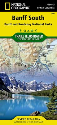
Wandelkaart 900 Banff South National Park | National Geographic

0
Prachtige geplastificeerde kaart van het bekende nationaal park. Met alle recreatieve voorzieningen als campsites, maar ook met topografische details en wandelroutes ed. Door uitgekiend kleurgebruik zeer prettig in gebruik. Scheur en watervast!   Banff & Kootenay National Parks Alberta/British Columbia, Canada Trail distances, Mount Assiniboine Pr...

Verkopers met dit product

Verkoper
Bezorging
Prijs
DeZwerver.nl logo
DeZwerver.nl
2,95
17,95

Anderen bekeken ook

Wandelkaart 901 Banff North National Park | National Geographic
Prachtige geplastificeerde kaart van het bekende nationaal park. Met alle recreatieve voorzieningen als campsites, maar ook met topografische details en wandelroutes ed. Door uitgekiend kleurgebruik zeer prettig in gebruik. Scheur en watervast! The front side of the Banff North map details the south side of the national park, from Siffleur Wilderness Area to the north, to Kootenay National Park to the south. This side also covers survival tips, area trails, entry fees and details both Kootenay and Yoho Nationals Parks. The reverse side of the map details the north side of the park, extending from Siffleur Wilderness area to the south, to White Goat Wilderness to the North. Insets show safe travel in Bear Country, and all the recreation the park has to offer with backpacking, camping, biking, hiking and horseback riding.  National Geographic's Trails Illustrated map of Banff North is a two-sided, waterproof map designed to meet the needs of outdoor enthusiasts with unmatched durability…
17,95
Wandelkaart - Wegenkaart - landkaart 902 Jasper South National Park | National Geographic
Goede kaart van een deel van Jasper National Park. Geschikt voor overzicht maar ook voor de langere trails: campsites, rivieren, paden, alles kun je er op terug vinden.   National Geographic's Trails Illustrated map of Jasper South is a two-sided, waterproof map designed to meet the needs of outdoor enthusiasts with unmatched durability and detail. This map was created in conjunction with local land management agencies and is loaded with valuable recreation information.   The front side of the Jasper South map details the east side of the national park, from Whitehorse Wildland Provincial Park to the north, to White Goat Wilderness Area to the south. The reverse side of the map details the west side of the park, extending from Cummins Lakes Provincial Park to the south, to Victoria Cross Ranges to the North. Insets show survival tips, safe travel in Bear Country, and all the recreation the park has to offer with backpacking, camping, biking, hiking and horseback riding.   Trails …
17,50
Wandelkaart - Wegenkaart - landkaart 903 Jasper North National Park | National Geographic
Goede kaart van een deel van Jasper National Park. Geschikt voor overzicht maar ook voor de langere trails: campsites, rivieren, paden, alles kun je er op terug vinden. National Geographic's Trails Illustrated map of Jasper North is a two-sided, waterproof map designed to meet the needs of outdoor enthusiasts with unmatched durability and detail. This map was created in conjunction with local land management agencies and is loaded with valuable recreation information.   The front side of Jasper North map details the east side of the national park, from Rock Lake Solomon Creek Wildland Park to the north, to Whistler's Summit to the south. The reverse side of the map details the west side of the park, extending from Mt. Terry Fox Provincial Park to the south, to Willmore Wilderness Park to the North. Insets show survival tips, safe travel in Bear Country, and what to do while visiting.   Trails Illustrated maps are expertly researched and frequently updated. The maps are printed in the …
17,50
Reisgids Canadian Rockies, met Banff en Jasper NP | Moon Travel Guides
Uitstekende Amerikaanse reisgids van uitgever Moon. De gids is vergelijkbaar met Lonely Planet en Rough guide en is voor de backpacker - zelfstandige reiziger geschreven; toch is deze door de grote mate van details en achtergronden geschikt voor alle reizigers! De gids onderscheidt zich door gedegen en uitgebreide achtergrondinformatie over bijvoorbeeld natuur en cultuur. Snowy peaks, icy glaciers, glittering lakes, and alpine meadows: Answer the call of the wild with Moon Canadian Rockies. Inside you'll find: Strategic, flexible itineraries in the national parks, including a two-week Canadian Rockies road trip The best hikes in the Canadian Rockies: Find the right trek for you with details on length, elevation gains, difficulty levels, and trailheads Can't-miss outdoor experiences: Hike to incredible vistas and try to spot moose, bighorn sheep, wolves, and black bears. Soak in a natural hot spring after a day on the slopes or wander through meadows of colorful wildflowers. Ride ac…
20,95
Wandelkaart - Topografische kaart 318 Mount Rogers High Country - Grayson Highlands State Park | National Geographic
Prachtige geplastificeerde kaart van het bekende nationaal park. Met alle recreatieve voorzieningen als campsites, maar ook met topografische details en wandelroutes ed. Door uitgekiend kleurgebruik zeer prettig in gebruik. Scheur en watervast!   National Geographic's Trails Illustrated map of Mount Rogers High Country and Grayson Highlands State Park, Southwest Virginia, is a two-sided, waterproof, topographic trail map designed to meet the needs of outdoor enthusiasts with unmatched durability and detail. This map was created in cooperation with local land management agencies and is loaded with valuable recreation information for exploring the area's large rock formations, spruce-fir forests, and the highest peak in Virginia. Trails and major roads, including the Appalachian Trail, the Virginia Creeper Trail, and the Virginia Highland Horse Trail, are clearly distinguished. Places of interest include areas for camping, picnicking, fishing, hiking, mountain biking, horseback riding, …
17,95
Wandelkaart - Topografische kaart 146 Uncompahgre Plateau South | National Geographic
Prachtige geplastificeerde kaart van het bekende nationaal park. Met alle recreatieve voorzieningen als campsites, maar ook met topografische details en wandelroutes ed. Door uitgekiend kleurgebruik zeer prettig in gebruik. Scheur en watervast!   National Geographic's Trails Illustrated map of Uncompahgre Plateau South is a two-sided, waterproof map designed to meet the needs of outdoor enthusiasts with unmatched durability and detail. This map was created in conjunction with local land management agencies and is loaded with valuable recreation information.   The front side of the map details the southeastern portion of the Plateau and Uncompahgre National Forest, as well as Ridgway State Park. On the reverse side of the map, the southwestern portion of Uncompahgre National Forest, including the Naturita Division, is featured as well as the Tabeguache Area, Roubideau Special Management Area, Unaweep/Tabeguache Scenic and Historic Byway, and Dry Creek Basin and Dan Noble State Wildl…
17,95
Wandelkaart 03 Bow Lake / Saskatchewan Crossing | Gem Trek Maps
Waterproof and tear-resistant hiking and recreation map for the Bow Lake and Saskatchewan Crossing region of Banff National Park.   Gem Trek's 1:70,000 Bow Lake and Saskatchewan Crossing Map is designed for outdoor enthusiasts looking to explore the Bow Lake and Saskatchewan Crossing region at the north end of Banff National Park. Whether you are touring along the roads or heading into the backcountry, you’ll find the waterproof and tear-resistant Bow Lake and Saskatchewan Crossing Map to be an invaluable tool. This map features detailed cartography, accurate hiking trails with distances, and details such as logging roads on the British Columbia side of the Continental Divide, campgrounds, picnic areas, and abandoned fire lookouts. On the back are descriptions of 24 recommended hikes, ranging from short walks to overnight treks, as well as details of services such as campgrounds and visitor centres.   Map specs     – Edition: 6th – Map scale: 1:70,000 – Sheet size: 27 x 39 inches – Fo…
18,95
Wandelkaart 17 Banff - Egypt Lake | Gem Trek Maps
Mooie, gedetailleerde kaart uit de serie van Gem Trek Hiking map-guides. Helder kleurgebruik en met de beste / mooiste wandelroutes, hikes en interessante plaatsen erop aangegeven. Gem Trek’s 1:50,000-scale BANFF–EGYPT LAKE MAP covers the most popular hiking trails in the immediate area of the town of Banff in more detail than our Banff & Mount Assiniboine Map.   The Banff–Egypt Lake Map features detailed cartography, accurate hiking trails with distances, and details such as side trips and backcountry campgrounds. For road travellers, it includes viewpoints, picnic areas, and campgrounds.   On the back of the map are trail descriptions of 17 recommended day hikes and four classic multi-day trips, all referenced to the map on the front. Also on the back is a list of trails recommended for early season, birdwatching, wildflowers, waterfalls, expansive views, awe-inspiring scenery, alpine meadows and rainy days. Included are contact numbers for visitor centres and backcountry booki…
17,95
Wandelkaart 10 Kootenay National Park | Gem Trek Maps
Kootenay National Park Wandelkaart – Gem Trek   Pluspunten & Minpunten ➕ Waterdicht en scheurvast – Ideaal voor gebruik in alle weersomstandigheden ➕ Zeer gedetailleerde cartografie – Inclusief hoogtelijnen, reliëfschaduw en hydrologische kenmerken ➕ Actuele en duidelijke wandelroutes – Met afstanden, namen en moeilijkheidsgraden ➕ Bevat populaire én minder bekende trails – Inclusief de volledige Rockwall Trail ➕ Extra informatie op de achterzijde – Trailbeschrijvingen, foto's, dagtochten, fietsroutes en contactgegevens ➕ Compact en praktisch formaat – Eén kaart dekt het hele park ➕ Inclusief Radium Hot Springs inzetkaart – Met wandelverbindingen naar bezienswaardigheden ➕ Geschikt voor zowel wandelaars als mountainbikers ➖ Kaart is Engelstalig – Niet alle gebruikers vinden dat prettig ➖ Bevat geen GPS-coördinaten – Minder geschikt voor gebruik met digitale navigatieapparatuur ➖ Schaal minder geschikt voor micro-navigatie – Voor zeer precieze terreinoriëntatie is aanvullen…
17,95
Wegenkaart - landkaart 3204 Adventure Map South Africa - Zuid Afrika | National Geographic
Wegenkaart van Zuid Afrika met vermelding van veel bezienswaardigheden, nationale parken en attrakties. Watervast en scheurvast. Juist door deze vermeldingen onderscheidt de kaart zich van andere wegenkaarten. National Geographic’s South Africa Adventure Map is designed to meet the unique needs of adventure travelers—detailed, durable, and accurate. It includes the locations of thousands of major cities and towns with an index for easily locating them, plus a clearly marked road network complete with distances and designations for major highways, limited access highways, and more. Both paved and unpaved roads, tracks, and trails are marked for those adventurers who wish to explore less traveled routes.   What sets National Geographic Adventure Maps apart from traditional road maps are the hundreds of points-of-interest that highlight the diverse, unique, and exotic destinations within South Africa including national parks and reserves, sanctuaries, World Heritage sites, archeological …
17,50

Klanten-reviews van Wandelkaart 900 Banff South National Park | National Geographic

Er zijn nog geen beoordelingen voor dit productBen jij de eerste die een review plaatst?

Meer over Wandelkaart 900 Banff South National Park | National Geographic

Productomschrijving

Prachtige geplastificeerde kaart van het bekende nationaal park. Met alle recreatieve voorzieningen als campsites, maar ook met topografische details en wandelroutes ed. Door uitgekiend kleurgebruik zeer prettig in gebruik. Scheur en watervast!   Banff & Kootenay National Parks Alberta/British Columbia, Canada Trail distances, Mount Assiniboine Provincial Park, Radium Hot Springs, Lake Minnewanka, Castle Mountain, Bow Valley Parkway Waterproof and tear-resistant Clearly marked trails for hiking, biking, horseback riding, ATV, and more Detailed topography and clearly defined, color-coded boundaries of state parks, national recreation areas, wilderness areas, marine sanctuaries, and wildlife refuges

Verken gerelateerde categorieën

Webshop.nl maakt gebruik van cookies. Ga je verder op onze website, ga dan akkoord met het plaatsen van cookies en de verwerking van deze data door ons en vermelde partners.