Wandelgids North Wales Limestone Way | Llygad Gwalch

0
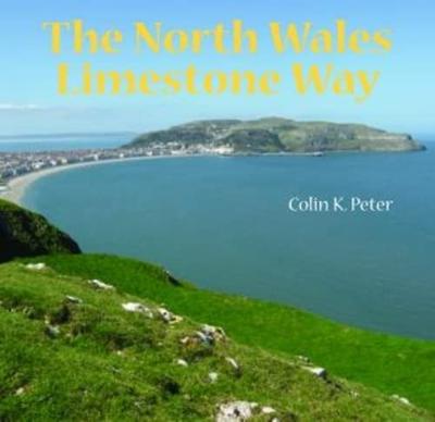
The North Wales Limestone Way is a newly-created 136km (85 mile) seven-stage route along the outcrop of the 340-330 million year old Carboniferous Limestone, from the iconic Great Orme in Llandudno along the north Wales coast and around the Vale of Clwyd, crossing the Clwydian Hills via a low pass to the limestone uplands of north-east Wales, to f...

Verkopers met dit product

Verkoper
Bezorging
Prijs
DeZwerver.nl logo
DeZwerver.nl
2,95
11,50

Anderen bekeken ook

Wandelgids 079 Pathfinder Guides Dee Valley, Clwydian Hills and North East Wales | Ordnance Survey
Fraaie, goed verzorgde wandelgidsjes met 28 wandelingen van max. een dag, (beginnend bij korte, eindigend bij langere wandelingen). Weergegeven op duidelijke topografische kaartjes (1:25.000). Bevat verder wetenswaardigheden en praktische informatie voor onderweg. Enjoy 145 miles of lush green walks in north-east Wales with 28 superb country walks, graded by length and difficulty. Choose from 14 routes in the Cylwdian Range and Dee Valley Area of Outstanding Natural Beauty, three on the North Wales coast between Great Orme and Point of Ayr and 11 in Denbighshire and Flintshire to the east of the River Conwy – or do them all!   Featured Dee Valley, Clwydian Hills and North-East Wales walks include:   - Follow the Wales Coast Path along the coastal sand dunes to Point of Ayr and Prestatyn - Circle Great Orme for impressive views of Llandudno, the coast and the mountains of Snowdonia - Stroll along the Llandudno Canal to the magnificent Pontcysyllte Aqueduct, a World Heritage Site - Ramb…
18,50
Reisgids Snowdonia & North Wales | Rough Guides
Een kleinere versie in zakformaat van de grotere versies van de Rough Guides. Als altijd weer vol met goede informatie over cultuur en praktische zaken. Voorrin een kaart van de regio. This compact, pocket-sized Snowdonia & North Wales travel guidebook is ideal for travellers on weekend trips or shorter breaks in the UK. It includes ready-made walking and driving itineraries that allow you to organise your visit to Snowdonia & North Wales without losing time planning.   The Snowdonia & North Wales guide book covers: The North Coast and Carneddau Mountains, A Tour of Anglesey, Beddgelert and Porthmadog, Snowdon from Caernarfon, The Lleyn Peninsula, Tremadog Bay to the Mawddach Estuary, Wrexham to Bala - and Back, Dolgellau to Cadair Idris and the Aran Mountains, Cadair Idris to Machynlleth.   Inside this Snowdonia & North Wales travel book you will find:   - 9 ready-made walks and tours - easy-to-follow walking and driving tour itineraries featuring the best places to visit, as…
14,95
Wandelgids The Offa's Dyke Path - Wales | Cicerone
Engelstalige beschrijving van de mooiste wandeltocht in Wales. De gids voldoet aan alle verwachtingen die je kunt hebben, het enige dat je mist is een overzichtskaart. Inclusief gidsje met routekaarten van 1:25000 (deze is hier ook los te bestellen) This guidebook - which includes both a guide to the route and a separate OS map booklet - describes Offa's Dyke Path National Trail from south to north, following the longest linear earthwork in Britain, running 177 miles along the English-Welsh border between Sedbury (near Chepstow) and Prestatyn on the north Wales Coast. It links the Severn Estuary and the Irish Sea, following the longest linear earthwork in Britain, contouring above the Wye and Dee, visiting hillforts and Norman castles and exploring the hidden heritage of the Marches. The route is exceptional in all seasons, although the Black Mountains and Clwydian range deserve respect in winter conditions.   The guidebook splits one of Britain's classic trails into 12 stages, with s…
25,95
Wandelgids The Cambrian Way | Cicerone
Uitstekende wandelgids van de Cambrian Way, waarbij naast alle noodzakelijke informatie ook gebruik gemaakt wordt van de echte topografische kaart.  Dubbed 'the mountain connoisseurs' walk', the Cambrian Way stretches 479km between the mighty castles of Cardiff in the south and Conwy on the north coast. Traversing the heartland of Wales, the challenging route crosses the Brecon Beacons, the Cambrian Mountains and Snowdonia, passing through two national parks and visiting many of the country's iconic summits, including Pen y Fan, Pumlumon, Cadair Idris and Snowdon itself. It can be walked in three weeks (or in shorter sections) and is suitable for experienced hillwalkers with sound navigational skills.   The guide presents the route in 21 stages, offering comprehensive route description illustrated with OS 1:50,000 mapping and elevation profiles. Details of accommodation and facilities are provided, along with a helpful trek planner showing their distribution along the route: although …
20,95
Wandelgids 50 Walks in Snowdonia and North Wales | AA Publishing
Uitstekende wandelgids met een aantal dagtochten tussen de 3 en 15 kilometer. Niet heel erg lang dus, maar wel op de mooiste plekken en goed beschreven en prima kaartmateriaal. Featuring a variety of mapped walks to suit all abilities, this helpful guide features all the necessary practical details for a successful trip, including information on distance, gradient, level of difficulty, landscape, dog friendliness, parking availability, and restroom locations. Fascinating background on the history and wildlife of each area is provided, and local points of interest are indicated on accompanying full-color maps. All walks are annotated with places to visit along the way--including churches, country houses, museums, villages, and towns--as well as information on local restaurants, tea rooms, and pubs. Revised with new routes and updated maps and information, these guides are your key to experiencing the beauty and variety of the British landscape. Casgliad o 50 taith gerdded amrywiol yn E…
19,95
Wandelgids Wales Coast Path: Snowdonia and Ceredigion | Northern Eye Books
Official Guide: Wales Coast Path: Snowdonia & Ceredigion Coast One of seven Official Guides to the Wales Coast Path This Official Guide to the Snowdonia & Ceredigion Coast section of the Wales Coast Path contains everything local and long-distance walkers need to enjoy the path.   Cardigan Bay probably offers a more diverse walking experience than any other section of the Wales Coast Path. The stretch covered in this book – from Porthmadog in the north to Cardigan in the south – largely covers two contrasting Welsh counties.   The first 97 kilometres pass through Gwynedd, along the western edge of the Snowdonia National Park. Here, just before the rivers that rise in the highest of the Welsh mountains reach the sea, they fan out to form broad estuaries that provide rich pickings for waders and other birdlife. The estuaries of the Dwyryd, the Mawddach and the Dyfi are the largest of these. Between them are some very large dune systems, including Morfa Harlech and Morfa Dyffryn – home t…
23,95
Wandelkaart North Wales Coast Path Map | Northern Eye Books
Enhanced, large scale (1: 25,000) Ordnance Survey mapping in a handy atlas format with all the mapping you need to walk a complete North Wales Coast section of the Wales Coast Path.   Continuous OS mapping covering the complete route from Chester to Bangor, on the Menai Strait. Contains generous coastal extracts from large-scale OS Explorer maps 266, 265, 264 and OL17.   The North Wales Coast Ordnance Survey mapping book is part of a series of map atlases covering the whole of the 870-mile long Wales Coast Path. The enhanced OS 1:25,000 maps are accurate, up-to-date and reliable. Additional map symbols show tea shops, cafes, extra parking, and public toilets.   A brief introduction to the North Wales Coast includes a fascinating photo mosaic highlighting notable views, places of interest and wildlife you’ll meet along the way. There is also a section of detailed Useful Information at the back of the atlas.   Laminated flapped covers showing Wales Coast Path signs and waymarkers, route…
16,50
Reisboek - Wandelgids Wild Swimming Walks Peak District | Wild Things Publishing
The best-selling Wild Swimming Walks series returns with adventures in Britain's oldest National Park. Ascend to the highest tarns and descend through a valley of secret waterfalls * Walk through woodland gorges carved by cascades * Follow bucolic river valleys dipping as you walk. Wild Swimming Walks Peak Disitrict leads you on 28 adventures in the soaring landscape of the Peak District. Find secret waterfalls, remote lakes and sparkling river pools. Complete with photos, maps and practical guidance, rich in local history and stories, this book will appeal to wild swimmers, family explorers, nature lovers and walkers alike.   JOIN THE ADVENTURE with the best-selling Wild Swimming Walks series and explore Britain’s oldest national park from the gritstone edges of the Hope Valley, to the magical streams on the moorlands of Bleaklow, through to the picturesque limestone river dales of the White Peak.   Scramble up streams and waterfalls at Black Clough Explore fairy pools and mossy…
20,95
Wandelgids The North Downs Way | Cicerone
Uitstekende wandelgids van de North Downs Way, waarbij naast alle noodzakelijke informatie ook gebruik gemaakt wordt van de echte topografische kaart. inclusief gidsje met routekaarten van 1:25000 A guidebook to walking the North Downs Way National Trail, a 130 mile (208km) walk between the high downland of Farnham and the historic city of Dover on the Kent coast, with an optional visit to Canterbury. The route is described in 11 stages, and is fully illustrated with colour photographs and OS map extracts. The North Downs Way is one of the easier national trails with a modest number of steep (but short) ascents and descents and long sections with no noticeable height gain or loss. Several historic sites including Neolithic burial chambers, Roman roads and Norman churches are passed and much of the route follows The Pilgrims' Way. The area also boasts many literary connections with some of the most celebrated voices in English literature. A separate pocket-sized map booklet is included…
23,95
Wandelgids guide to the Wye Valley Walk - Welsh borders, Wales | Cicerone
Uitstekende wandelgids van dit geweldige gebied. goed beschreven met veel praktische informatie om de route te kunnen lopen, inclusief goede kaarten. The official guide to backpacking or walking the Wye Valley Walk, 136 miles through the Welsh borders, crossing between south Wales and Herefordshire, from Chepstow to Plynlimon. Easy walking through wooded gorges, riverside meadows and open moorland, passing sites such as Tintern Abbey, Goodrich Castle, Hereford Cathedral and Hay-on-Wye. The Wye Valley Way offers a perfect mix of river and hill walking as it follows the River Wye for 136 miles from river’s mouth at Chepstow to the slopes of Plynlimon in Powys criss -crossing the border between England and Wales. The walk leads through a dramatic limestone gorge, dense woodland beneath limestone crags and past peaceful river meadows in some of the most superb scenery in the heart of the Wye Valley Area of Outstanding Natural Beauty, the birthplace of tourism and the Picturesque movement.…
21,95

Klanten-reviews van Wandelgids North Wales Limestone Way | Llygad Gwalch

Er zijn nog geen beoordelingen voor dit productBen jij de eerste die een review plaatst?

Meer over Wandelgids North Wales Limestone Way | Llygad Gwalch

Productomschrijving

The North Wales Limestone Way is a newly-created 136km (85 mile) seven-stage route along the outcrop of the 340-330 million year old Carboniferous Limestone, from the iconic Great Orme in Llandudno along the north Wales coast and around the Vale of Clwyd, crossing the Clwydian Hills via a low pass to the limestone uplands of north-east Wales, to finish on the coast at Prestatyn.   The route starts and ends in popular Victorian seaside resorts, but in between moves inland to much quieter places. It covers a wealth of history and pre-history passing Stone Age cave dwellings, Bronze Age copper mines, Iron Age hillforts, Roman ruins, Norman castles and walled towns, historic houses and remnants of the industrial past through to modern Wales with offshore wind farms and oil/gas platforms. Coastal and inland scenery is stunning with nature reserves and their specialised floras widespread. The limestone gives good walking, usually dry underfoot, with a scattering of limestone villages; drystone walls often defining the fields, and woodlands carpeted with spring flowers.   Canllaw hwylus mewn saith cam i Lwybr Calchfaen Gogledd Cymru sy'n 136cilomedr (85 milltir) o hyd. Dilynir y Llwybr o Ben y Gogarth yn Llandudno, ar hyd arfordir gogledd Cymru ac o gwmpas Dyffryn Clwyd, ar draws Bryniau Clwyd trwy fwlch isel i ucheldiroedd calchfaen gogledd-ddwyrain Cymru, cyn cloi'r daith ar yr arfordir ym Mhrestatyn.

Verken gerelateerde categorieën

Webshop.nl maakt gebruik van cookies. Ga je verder op onze website, ga dan akkoord met het plaatsen van cookies en de verwerking van deze data door ons en vermelde partners.