webshop.nl
Categorieën
  Sluiten

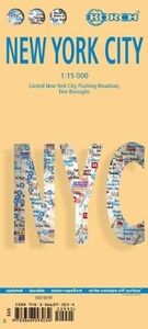
Stadsplattegrond New York City | Borch

Borch New York City is een duidelijke, geplastificeerde plattegrond van het centrum van New York (Manhattan) en nog een stukje van Brooklyn en Queens met informatie over openbaar vervoer en bezienswaardigheden. Inclusief straatnamenregister.   Our soft-laminated folded map of New York City shows: Central New York City 1:15 000, Flushing Meadows 1:1...
10,25

Webshops met dit product

Webshop
Bezorging
Prijs

Anderen bekeken ook

Stadsplattegrond Manhattan (New York City) | Borch
Borch Manhattan is een duidelijke, geplastificeerde plattegrond met informatie over openbaar vervoer en bezienswaardigheden. Inclusief straatnamenregister.   Our soft-laminated folded map of Manhattan shows: Manhattan (Lower & Midtown) 1:15 000, Manhattan (Upper) 1:15 000, Midtown 1:10 000, Financial District 1:9 000, Public Transport New York City, USA administrative & time zones, Manhattan Zip-Codes, USA administrative & time zones and the Top 30 Sights. Borch Maps are easy to fold, durable and water-repellent with a wipeable surface. Borch Maps show hotels, museums, monuments, markets, public transport, top sights and points of interest, useful statistics, conversion charts for temperatures, weights and measurements, climate charts showing temperatures, sunshine hours, precipitation and humidity, overview maps, time zones, and much more...   Manhattan is one of the five boroughs of New York City (the other four boroughs are the Bronx, Queens, Brooklyn and Staten Island) and on a lan…
10,25
Stadsplattegrond Sydney | Borch
Borch Sydney is een duidelijke, geplastificeerde plattegrond van het centrum met informatie over openbaar vervoer en bezienswaardigheden. Inclusief straatnamenregister. Our soft-laminated folded map of Sydney shows: Inner Sydney 1:15 000, Sydney CBD 1:7 500, Sydney 1:120 000, Sydney & Region 1:450 000, Homebush Bay Olympic Park 1:15 000, Airport Sydney 1:25 000, Public Transport Sydney, Australia administrative & time zones, Top 30 Sights. Borch Maps show hotels, museums, monuments, markets, public transport, top sights and points of interest, useful statistics, conversion charts for temperatures, weights and measurements, climate charts showing temperatures, sunshine hours, precipitation and humidity, overview maps, time zones, and much more...   Sydney, the capital city of the state New South Wales, is Australia's most populous city with an estimated 4.2 million inhabitants in its metropolitan area. Located on the southeastern coast, Sydney is built around Port Jackson, a section of …
10,25
Stadsplattegrond Las Vegas | Borch
Borch Las Vegas is een duidelijke, geplastificeerde plattegrond van het centrum met informatie over openbaar vervoer en bezienswaardigheden. Inclusief straatnamenregister.   Our soft-laminated folded map of Las Vegas shows: Las Vegas 1:20 000, Las Vegas & Region 1:150 000, Las Vegas & National Parks 1:3 000 000, Grand Canyon National Park 1:225 000, Grand Canyon Village 1:40 000, USA administrative & time zones, Top 30 Sights. Borch Maps are easy to fold, durable and water-repellent with a wipeable surface. Borch Maps show hotels, museums, monuments, markets, public transport, top sights and points of interest, useful statistics, conversion charts for temperatures, weights and measurements, climate charts showing temperatures, sunshine hours, precipitation and humidity, overview maps, time zones, and much more...   Las Vegas, literally translated as "The Meadows", is also known as "Sin City" and is the most populous city in the state of Nevada, with the largest number of hotel rooms in…
10,25
Stadsplattegrond Singapore | Borch
Borch Singapore is een duidelijke, geplastificeerde plattegrond van het centrum met informatie over openbaar vervoer en bezienswaardigheden. Inclusief straatnamenregister. Our soft-laminated folded map of Singapore shows: Singapore City 1:14 000, Singapore 1:120 000, Sentosa Island 1:25 000, Changi Airport 1:4 000 and the Public Transportation SMRT schematic map. Borch Maps are easy to fold, durable and water-repellent with a wipeable surface. Borch Maps show hotels, museums, monuments, markets, public transport, top sights and points of interest, useful statistics, conversion charts for temperatures, weights and measurements, climate charts showing temperatures, sunshine hours, precipitation and sea temperatures, overview maps and much more...   The Republic of Singapore (also known as "Lion City", although history tells us Singapore's founder probably meant "tigers") is a very clean and orderly city-state located on the southern tip of the Malay Peninsula, with Changi airport usually…
10,25
Stadsplattegrond Toronto | Borch
Borch Toronto is een duidelijke, geplastificeerde plattegrond van het centrum met informatie over openbaar vervoer en bezienswaardigheden. Inclusief straatnamenregister.   Our soft-laminated folded map of Toronto shows: Toronto City 1:17 500, The Beaches 1:17 500, Toronto Islands 1:20 000, Toronto & Region 1:500 000, Niagara Falls 1:25 000, Public Transport Toronto, Canada administrative & time zones and Top 30 Sights. Borch Maps are easy to fold, durable and water-repellent with a wipeable surface. Borch Maps show hotels, museums, monuments, markets, public transport, top sights and points of interest, useful statistics, conversion charts for temperatures, weights and measurements, climate charts showing temperatures, sunshine hours, precipitation and humidity, overview maps, time zones, and much more...   Toronto, Canada’s largest city and commercial capital, is the capital of the province of Ontario. Telecommunication, transportation, aerospace, business services, finance, media, fi…
10,25
Stadsplattegrond Madrid | Borch
Borch Madrid is een duidelijke, geplastificeerde plattegrond van het centrum met informatie over openbaar vervoer en bezienswaardigheden. Inclusief straatnamenregister.   Our soft-laminated folded map of Madrid shows: Central Madrid 1:10 000, Madrid & Region 1:200 000, Province of Madrid 1:700 000, Toledo 1:9 000, Segovia 1:8 500, Public Transport Madrid, Spain administrative. Borch maps are easy to fold, durable and water-repellent with a wipeable surface. Borch Maps show hotels, museums, monuments, markets, public transport, top sights and points of interest, useful statistics, conversion charts for temperatures, weights and measurements, climate charts showing temperatures, sunshine hours, precipitation and humidity, overview maps, time zones, and much more...   Madrid, located on the Manzanares River, is the capital and largest city of Spain and also its political and geographic center. Local residents are called Madrileños. Not only is Madrid one of the main financial centers of t…
10,25
Stadsplattegrond Tokyo - Tokio | Borch
Borch Tokio is een duidelijke, geplastificeerde plattegrond van het centrum met informatie over openbaar vervoer en bezienswaardigheden. Inclusief straatnamenregister.   Our soft-laminated folded map of Tokyo shows: Tokyo 1:17 000, Tokyo Bay & Shinagawa 1:19 000, Tokyo & Region 1:1 300 000, Tokyo Subway Route Map, Japan administrative and time zones, Top 30 Sights. Borch Maps are easy to fold, durable and water-repellent with a wipeable surface. Borch Maps show hotels, museums, monuments, markets, public transport, top sights and points of interest, useful statistics, conversion charts for temperatures, weights and measurements, climate charts showing temperatures, sunshine hours, precipitation and humidity, overview maps, time zones, and much more...   Tokyo, the vast capital city of Japan, is also one of the 47 Japanese prefectures. Tokyo means "Eastern Capital", is located in the Kanto region on the southeastern tip of Honshu (the main island of Japan), is home to the Japanese gover…
10,25
Stadsplattegrond Istanbul | Borch
Borch Istanbul is een duidelijke, geplastificeerde plattegrond van het centrum met informatie over openbaar vervoer en bezienswaardigheden. Inclusief straatnamenregister.   Our soft-laminated folded map of Istanbul shows: Istanbul 1:11 000, Topkapi Palace 1:4 000, Grand Bazaar 1:3 000, Üsküdar 1:13 000, Greater Istanbul 1:150 000, Northwestern Turkey 1:2 000 000, Public Transport Istanbul, Turkey administrative & time zones, Top 30 sights. Borch Maps are easy to fold, durable and water-repellent with a wipeable surface. Borch Maps show hotels, museums, monuments, markets, public transport, top sights and points of interest, useful statistics, conversion charts for temperatures, weights and measurements, climate charts showing temperatures, sunshine hours, precipitation and humidity, overview maps, time zones, and much more...   Istanbul (formerly known as Byzantium and Constantinople) is Europe's most populous city (circa 13 million inhabitants) and is located on the Bosphorus Strait. …
10,25
Stadsplattegrond Firenze - Florence | Borch
Borch Florence is een duidelijke, geplastificeerde plattegrond van het centrum met informatie over openbaar vervoer en bezienswaardigheden. Inclusief straatnamenregister.   Our soft-laminated folded map of Florence shows: Florence Centre 1:7 000, Fiésole 1:12 000, Pisa 1:7 000, Florence & Environs 1:80 000, Florence & Region 1: 450 000 Cathedral of Santa Maria del Fiore 1: 1 900, Italy administrative, Top 24 Sights of Florence and 12 of Pisa. Borch maps are easy to fold, durable and water-repellent with a wipeable surface. Borch Maps show hotels, museums, monuments, markets, top sights and points of interest, useful statistics, conversion charts for temperatures, weights and measurements, climate charts showing temperatures, sunshine hours, precipitation and humidity, overview maps, time zones, and much more...   Florence is famous for its unparalleled art and architecture and is known as the birthplace of the Italian Renaissance. It is the capital city of the region of Tuscany, is sit…
10,25
Stadsplattegrond Los Angeles | Borch
Borch Los Angeles is een duidelijke, geplastificeerde plattegrond van het centrum met informatie over openbaar vervoer en bezienswaardigheden. Inclusief straatnamenregister.   Our soft-laminated folded map of Los Angeles shows: Los Angeles 1:60 000, L.A. Downtown 1:17 000, Santa Monica & Venice 1:20 000, Hollywood 1:15 000, L.A. & Region 1:225 000, L.A. Airport 1:20 000, Public Transport Los Angeles, USA administrative and time zones, Top 30 Sights. Borch maps are easy to fold, durable and water-repellent with a wipeable surface. Borch Maps show hotels, museums, monuments, markets, public transport, top sights and points of interest, useful statistics, conversion charts for temperatures, weights and measurements, climate charts showing temperatures, sunshine hours, precipitation and humidity, overview maps, time zones, and much more...   Abbreviated L.A., Los Angeles is the most populous city in California and the 2nd largest English-speaking city in the world. It is best known for bei…
11,50

Klanten-reviews van Stadsplattegrond New York City | Borch

Er zijn nog geen beoordelingen voor dit productBen jij de eerste die een review plaatst?

Meer over Stadsplattegrond New York City | Borch

Productomschrijving

Borch New York City is een duidelijke, geplastificeerde plattegrond van het centrum van New York (Manhattan) en nog een stukje van Brooklyn en Queens met informatie over openbaar vervoer en bezienswaardigheden. Inclusief straatnamenregister.   Our soft-laminated folded map of New York City shows: Central New York City 1:15 000, Flushing Meadows 1:15 000, Five Boroughs 1:100 000, Public Transport New York City, USA administrative & time zones. Borch Maps are easy to fold, durable and water-repellent with a wipeable surface. Borch Maps show hotels, museums, monuments, markets, public transport, top sights and points of interest, useful statistics, conversion charts for temperatures, weights and measurements, climate charts showing temperatures, sunshine hours, precipitation and humidity, overview maps, time zones, and much more...   Nicknamed "The Big Apple", NYC is the most populous city in the United States. Situated in the state of New York, the city has served as the gateway to the USA for countless immigrants from countries all over the world. New York has the highest population density in North America and its metropolitan area counting approx. 18.9 million residents is one of the largest urban areas in the world. New York is the ultimate world metropolis, influential as a business and economic center, and since World War II as a financial center of both national and global importance. Home to the United Nations, New York is a major platform for international diplomacy. Innumerable galleries, performance venues and hundreds of museums confirm the fact that New York is one of the most important cultural centers of the world. Various movements such as the Harlem Renaissance in visual art and literature, abstract expressionism in painting and hip-hop in music, had their beginnings in this cultural melting pot. Always something to do, hear, see, experience - New York really is "the city that never sleeps".  
Webshop.nl maakt gebruik van cookies. Ga je verder op onze website, ga dan akkoord met het plaatsen van cookies en de verwerking van deze data door ons en vermelde partners.