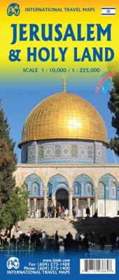
Stadsplattegrond Jerusalem & Holy Land - Jeruzalem en Noord Israël | ITMB

0
Een goede kaart van Jeruzalem en op de andere zijde noord- Israel met een schaal van 1:225.000, gedrukt op scheur- en watervast papier. Let op: de index van de kaart bevat plaatsnamen van geheel Israël en bevat zodoende plaatsnamen die niet op deze kaart staan. Jerusalem is an ancient city and also a religious centre, revered by Christians and Mus...

Verkopers met dit product

Verkoper
Bezorging
Prijs
DeZwerver.nl logo
DeZwerver.nl
2,95
13,95

Anderen bekeken ook

Stadsplattegrond Jerusalem - Jeruzalem | Borch
Borch Jerusalem is een duidelijke, geplastificeerde plattegrond van het centrum met informatie over openbaar vervoer en bezienswaardigheden. Inclusief straatnamenregister.   Jerusalem 1:8 000, Bethlehem 1:11 000, Greater Jerusalem 1:30 000, Central Israel 1:400 000, Dome of the Rock, Holy Sepulchre, The Middle East administrative & Time Zones   Our soft-laminated folded map of Jerusalem shows: Jerusalem 1:8 000, Bethlehem 1:11 000, Greater Jerusalem 1:30 000, Central Israel 1:400 000, Dome of the Rock, Holy Sepulchre, The Middle East administrative & time zones and Top 30 Sights. Borch maps are easy to fold, durable and water-repellent with a wipeable surface. Borch Maps show hotels, museums, monuments, markets, public transport, top sights and points of interest, useful statistics, conversion charts for temperatures, weights and measurements, climate charts showing temperatures, sunshine hours, precipitation and humidity, overview maps, time zones, and much more...   One of the most …
9,95
Wegenkaart - landkaart Tel Aviv - Jaffa en Centraal Israel | ITMB
Een kaart die naast het wegennet en plaatsen ook de nadruk legt op de natuurkundige aspecten van het land of gebied. Met kleur worden de verschillende hoogtelagen weergegeven, waardoor je een mooi beeld krijgt van het land. Met symbolen worden bijvoorbeeld benzinepompen aangeduid maar ook stranden. Grote plattegrond Tel Aviv op schaal 1:12.000 Op andere zijde kaart van Centraal Israel op schaal 1:220.000 This map resulted from our visit to Israel a couple of years ago. We got lost in Tel Aviv and wasted a lot of time trying to find our way to where we were staying. Although quite good maps of Tel Aviv exist, most are in Hebrew and are very "Israeli". We decided to do a map that combined the newish city of Tel Aviv with its older and more exotic neighbour, Jaffa, which is currently dominated by those of a non-Jewish orientation. Jaffa is the ancient port used by Phoenicians, Greeks, Romans, and traders plying the Silk Road to China. Its old town is quite compact and a treat to explore.…
13,95
Stadsplattegrond Jerusalem - Jeruzalem | Freytag & Berndt
Stadsplattegrond met register. Helder kaartbeeld waarbij de naamgeving goed leesbaar is weergegeven. Met de toeristische bezienswaardigheden in symbolen weergeven: monumenten, musea, stadions e.a. Daarnaast handige zaken als postkantoren, parkeergarages en stations. Veelal ook met een openbaar vervoer of metro kaart als inzet Large, general street plan of the city with a clear enlargement of the Old City at 1:4,500. The main plan extends west to beyond the Jerusalem Forest and east to Mount of Olives. Coverage north/south is from Ramat Polin and Beit Khanina to Gilo. Public buildings a highlighted and symbols mark places of worships, monuments, etc. A large inset provides more detailed coverage of the Old City, indicating various places of worship and historical monuments, car parks, etc. All place names are in Roman alphabet only. Multilingual map legend included English and Hebrew.
13,95
Stadsplattegrond Jakarta en omgeving | ITMB
Kaart van het centrum op gedetailleerde schaal en een kaart op de achterzijde van de regio en voorsteden op een schaal van 75.000. Indonesia is emerging quickly as one of the power-houses of Asia. Jakarta is a huge urban area, with a charming city centre. This double-sided map shows Greater Jakarta on one side, with its expressways and inter-urban train network and is, in my opinion very useful to business visitors to the city. It includes the airport, the city centre, the enormous soccer stadium (worth a visit), and the roads connecting the different neighbourhoods of this spread-out city. The other side concentrates on the central core of Jakarta, which is where most visitors would spend most time. Road and rail connections are clearly shown, as well as a good range of embassies, museums, hotels, gas stations, religious buildings, hospitals, and touristic attractions. Asian cities tend not to be well-mapped; the last map of the city that I recall was done about ten years ago, so thi…
13,95
Stadsplattegrond - Wegenkaart - landkaart Cardiff & Wales | ITMB
Een dubbelzijdige kaart met aan de ene zijde een plattegrond van Cardiff, schaal 1:8.000 en op de andere zijde een wegenkaart, schaal 1:300.000, met aanduidingen van o.a. nationale parken, vliegveld, benzinepompen. ITMB finds the UK to be a never-ending source of maps needing to be prepared, such as this one of Cardiff and Wales. Cardiff is the capital of Wales, and is also an international access point to the UK; a map seems desirable. The city is based at the mouth of the River Taff, with most touristic points being concentrated in the harbour area, the city centre, and a concentration of eateries along Albany Road. Cardiff is shaped by two parallel motorways; the A4232close to the waterfront, and the A48 near the northern extremities. Both are included in our map, which also shows historic sites, hotels, and tourist amenities. The reverse side shows all of Wales as an entity, showing roads, rail lines, ferry crossing points, and access routes to England. It also shows historic site…
13,95
Reisgids Eyewitness Travel Jerusalem, Israel and the Palestinian Territories | Dorling Kindersley
Prachtig geillustreerde reisgids met o.a. 3D tekeningen, fraaie kaarten en geweldige foto’s. Daarnaast uitgebreide achtergrondbeschrijvingen. Echt om in de stemming te komen! De engelstalige versie van de Capitool Reisgids. Infused with a fascinating mix of cultural influences, sacred sites and ancient ruins, you'll be itching to book a trip to Jerusalem! This updated travel guide brings Jerusalem, Israel and the Palestinian territories to life, transporting you to a landscape of dramatic desert outcrops and Mediterranean beaches that have enchanted visitors since the dawn of civilization. Discover serene sacred sights and bustling Bauhaus boulevards. This updated eyewitness travel guide includes: - Our pick of Jerusalem, Israel and the Palestinian Territories' must-sees, top experiences, and hidden gems - The best spots to eat, drink, shop and stay - Detailed maps and walks make navigating the region easy - Easy-to-follow itineraries - Expert advice: get ready, get around and stay …
22,50
Wegenkaart - landkaart - Stadsplattegrond San Diego - California south | ITMB
Wegenkaart en stadsplattegrond in een kaart: aan de ene zijde San Diego stadsplattegrond en op de andere kant een kaart van het zuiden van Californië. San Diego on a clear, well presented street plan from ITMB, with a transit system diagram, a road map of the city and its environs, and a street plan of central Tijuana, plus on the reverse a road map of the US/Mexico border region extending east beyond El Paso and within USA north to Las Vegas.   On one side is an indexed street plan of San Diego, covering the city’s central districts (as indicated in our coverage image), including the downtown area, the Old Town for which an enlargement is provided, Balboa Park, University Heights, the Mission Bay Park with the SeaWorld, and the city’s international airport. The plan clearly shows the MTS and other public transit stations, highlights main traffic arteries and indicates one way streets. Also marked are recommended cycle routes. Streets are annotated with selected block numbers for easi…
13,95
Wegenkaart - landkaart Palestine & Jerusalem - Palestina | ITMB
This is a new title for ITMB and the first time a separate map for that portion of the area known as Palestine and controlled by Palestinians has been published. This is essentially an attempt to show a political reality that exists, in that no one denies that both the West Bank and the Gaza Strip exist, albeit as a tightly-controlled entity that is not a country in the traditional sense of the word but is, nonetheless the homeland of millions of people and a self-governing entity. Jerusalem has been shown as an entity, without a border, in order to emphasize its importance as a unifying point of three great religions. Barricades do exist within the city, but these exist mostly to prevent clashes and reduce frictions, and we prefer to concentrate our hopes for Jerusalem as a future symbol of unity. Geographically, to fit both the southerly Gaza Strip area and the northerly West Bank portion together, it has been necessary to include large portions of Israel proper. The border has been…
13,95
Reisgids Pocket Jerusalem and Tel Aviv | Lonely Planet
Pocket reisgidsen van Lonely Planet zijn een kleinere versie dan de 'echte' Planets. Vaak echter van bijzondere bestemmingen binnen een bepaald land waardoor er meer aandacht is en uitgebreidere tips zijn voor die bepaalde streek i.v.m. de grote Planets. Handzaam formaat, makkelijk in de binnenzak! Toch ook deze vol met praktische informatie. Lonely Planet's Pocket Jerusalem & Tel Aviv is your passport to the most relevant, up-to-date advice on what to see and skip, and what hidden discoveries await you. Gaze at the architectural magnificence of the Temple Mount / Al Haram Ash Sharif, feel the spiritual power of the Western Wall and weave between mounds of fresh produce and cafes at Mahane Yehuda Market - all with your trusted travel companion. Get to the heart of Jerusalem & Tel Aviv and begin your journey now! Inside Lonely Planet's Pocket Jerusalem & Tel Aviv: Full-colour maps and images throughout Highlights and itineraries help you tailor your trip to your personal needs and i…
12,95
Stadsplattegrond Bangkok en omgeving | Nelles Verlag
Goede stadskaart van Bangkok en omgeving. Aan beide kanten bedrukt. Met veel toeristische aanduidingen als culturele bezienswaardigheden en aanduidingen van bijvoorbeeld de grotere hotels. Prima leesbare kaart. Bangkok on a double-sided map from Nelles combining an indexed street plan of the city’s central districts at 1:15,000 with a more general plan of the capital with its outer suburbs presented at 1:75,000. Both plans highlight numerous places of interest.   On one side the main, indexed plan covers the city’s inner districts showing public transport routes: metro and skytrain lines with stations, bus routes with line numbers, and express boat service along the river. Public buildings, including selected hotels, are clearly marked and named, and shopping centres or market streets are indicated. The main centre of tourist accommodation, Banglamphoo - Khao San Road area, is also shown in greater detail on a small enlargement.   On the reverse a more general plan at 1:75,000 covers …
11,95

Klanten-reviews van Stadsplattegrond Jerusalem & Holy Land - Jeruzalem en Noord Israël | ITMB

Er zijn nog geen beoordelingen voor dit productBen jij de eerste die een review plaatst?

Meer over Stadsplattegrond Jerusalem & Holy Land - Jeruzalem en Noord Israël | ITMB

Productomschrijving

Een goede kaart van Jeruzalem en op de andere zijde noord- Israel met een schaal van 1:225.000, gedrukt op scheur- en watervast papier. Let op: de index van de kaart bevat plaatsnamen van geheel Israël en bevat zodoende plaatsnamen die niet op deze kaart staan.

Jerusalem is an ancient city and also a religious centre, revered by Christians and Muslims alike. Lan and I visited the city in January and updated minor changes to the old walled city. We also wanted to change the regional map, but not its coverage or content, so we changed its name to Holy Land, on the assumption that the market for this map rests with pilgrims and those following well-known Biblical place names: the Sea of Galilee, Bethlehem, Nazareth etc. On our trip, we also discovered Agamemnon, which I'd believed to be mythological, and the crusader fortress of Acre, on the coast. Israel/Palestine offers so much more than 'just' Jerusalem that a map of this nature is essential for anyone visiting this part of the world.   Legend Includes: Road by classification, Expressway, Major road, Secondary Road, Metro station, University, Point of interest, Post Office, Shopping Centre, Consulate, Sports Facility and much more...

Verken gerelateerde categorieën

Webshop.nl maakt gebruik van cookies. Ga je verder op onze website, ga dan akkoord met het plaatsen van cookies en de verwerking van deze data door ons en vermelde partners.