Kinderpuzzel GeoPuzzle Africa and the Middle East - Afrika en het Midden Oosten | GEOtoys

0
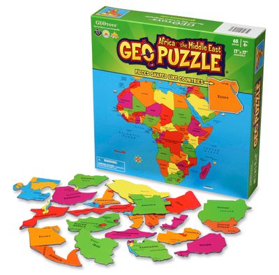
Unieke, educatieve puzzel van Afrika en het Midden Oosten met 65 puzzelstukjes in landvormen.  Gemaakt van gerecycled materiaal en ontwikkeld voor kinderen vanaf 4 jaar.   GeoPuzzles are maps of the major continents, with pieces shaped like individual countries. By putting together a GeoPuzzle, children learn what countries look like, what their n...

Verkopers met dit product

Webshop
Bezorging
Prijs
DeZwerver.nl logo
DeZwerver.nl
niet bekend
18,95

Anderen bekeken ook

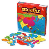
Kinderpuzzel GeoPuzzle Asia - Azië | GEOtoys
Unieke, educatieve puzzel van Azië met 50 puzzelstukjes in landvormen.  Gemaakt van gerecycled materiaal en ontwikkeld voor kinderen vanaf 4 jaar.   GeoPuzzles are maps of the major continents, with pieces shaped like individual countries. By putting together a GeoPuzzle, children learn what countries look like, what their names are, and where they are in relation to one another. At 50-70 pieces, the puzzles are perfect for ages 4-12. Designed by an art professor, GeoPuzzles are generously sized, brightly colored, and each piece is large enough to be easily handled.   The Asia GeoPuzzle does not include the Middle East. Though the Middle East is geographically part of the Asian landmass, it is culturally associated with North Africa. The Middle East has been included with the Africa GeoPuzzle.   GeoPuzzle Asia has 50 pieces, and is a jumbo-sized 19 x 16 inches.
18,95
Kinderpuzzel GeoPuzzle Latin America - Latijns Amerika | GEOtoys
Unieke, educatieve puzzel van Latijns Amerika met 50 puzzelstukjes in landvormen.  Gemaakt van gerecycled materiaal en ontwikkeld voor kinderen vanaf 4 jaar.   GeoPuzzles are maps of the major continents, with pieces shaped like individual countries. By putting together a GeoPuzzle, children learn what countries look like, what their names are, and where they are in relation to one another. At 50-70 pieces, the puzzles are perfect for ages 4-12. Designed by an art professor, GeoPuzzles are generously sized, brightly colored, and each piece is large enough to be easily handled.    
18,95
Magneetbord Middle East - Midden Oosten | National Geographic
Magneetbord - Wandkaart van het Midden Oosten, met o.a. Afghanistan - Pakistan - National Geographic wandkaart geplastificeerd - Afmeting ca 76 x 58cm    National Geographic Maps' recently updated wall map of the Middle East region, formerly titled Afghanistan/Pakistan and the Middle East.   Includes updated place names and the addition of significant locations currently in the news, such as Marjah, Afghanistan. This wall map covers a broad geographic area ranging from northern Africa through the Middle East to the western edge of China and India.   Includes complete coverage of Afghanistan, Pakistan, Tajikistan, Iran, Iraq, Kuwait, Syria, Israel, Jordan, Lebanon, Saudi Arabia, Qatar, Bahrain, United Arab Emirates, Yemen, Oman, Cyprus, and Eritrea.   Also includes parts of India, China, Kyrgyzstan, Uzbekistan, Turkmenistan, Azerbaijan, Armenia, Turkey, Egypt, Sudan, Ethiopia, and Djibouti. Features thousands of place names, accurate political boundaries, archeological sites, and major…
189,-
Reisverhaal Dreaming of Jupiter | Ted Simon
Ted Simon is the author of the classic travel book JUPITER'S TRAVELS. It documents his four-year journey round the world by motorbike, travelling through Europe, Africa, South and North America, and Asia. A number one bestseller in the late 1970s, it is still regarded as one of the greatest motorcycle books - indeed, one of the greatest travel books - ever written. In 2001, at the age of 69, Ted Simon decided to retrace his journey, and DREAMING OF JUPITER is the result. It took him two and a half years - during which time he revisited all the countries he had travelled through in the 1970s. He found much had changed, and he reflects upon the increased poverty, political upheavals, environmental issues and indeed the changes in himself. But ultimately, DREAMING OF JUPITER is a hugely inspiring read with a positive message at its heart - that even at the age of 70 you can still set off on an adventure, and be surprised and excited by what life throws at you along the way. *'Gloriously …
14,50
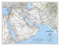
Wandkaart Middle East - Midden Oosten 76 x 58 cm | National Geographic
Wandkaart van het Midden Oosten, met o.a. Afghanistan - Pakistan - National Geographic wandkaart geplastificeerd - Afmeting ca 76 x 58 cm  National Geographic Maps' recently updated wall map of the Middle East region, formerly titled Afghanistan/Pakistan and the Middle East. Includes updated place names and the addition of significant locations currently in the news, such as Marjah, Afghanistan. This wall map covers a broad geographic area ranging from northern Africa through the Middle East to the western edge of China and India.   Includes complete coverage of Afghanistan, Pakistan, Tajikistan, Iran, Iraq, Kuwait, Syria, Israel, Jordan, Lebanon, Saudi Arabia, Qatar, Bahrain, United Arab Emirates, Yemen, Oman, Cyprus, and Eritrea.   Also includes parts of India, China, Kyrgyzstan, Uzbekistan, Turkmenistan, Azerbaijan, Armenia, Turkey, Egypt, Sudan, Ethiopia, and Djibouti. Features thousands of place names, accurate political boundaries, archeological sites, and major infrastructure n…
31,95
Fietsgids A Cyclist's Guide to the Pyrenees | Great Northern Books
Where do you turn when you want to ride in the mountains, to follow in the wheeltracks of professional racers by climbing the famous passes of the Tour de France? There are several books and websites that highlight these renowned ascents, detailing their location, length and every little change in gradient. But how do you go about finding a route that links these passes together, that describes not only where they are and what they're like to ride, but highlights which is the best side to tackle them from and which roads to avoid?Award-winning author Peter Cossins's new series of guides to riding in the Western Europe's high mountains will provide these details - and much more. Inspired by Alfred Wainwright's walking guides to the Lake District, they are intended as the bible for any cyclist riding in Europe's most stunning terrain.   The first in the series is The Roads, Cols and Passes of the Pyrenees, which is duefor publication by Great Northern Books in June 2020. Featuring 120 r…
23,95
Vogelgids Birds of Europe, North Africa, and the Middle East: A Photographic Guide | Princeton University Press
Birds of Europe, North Africa, and the Middle East is the first comprehensive pocket-sized photographic field guide to every bird species in Europe – this includes winter visitors and common migrants but also all rarities to the region, even if they have been recorded only once. The guide also covers hypothetical species – those that have a good chance of being recorded due to such factors as range expansion and changing weather patterns.   The book's 2,200 stunning color photographs mean that every species is pictured, making field identification quick and easy. Succinct text covers key identification features, voice, habitat, and distribution, and distribution maps are provided for regular breeding species. Particular attention and details are given to help differentiate similar-looking species.   Lavishly illustrated, up-to-date, and wide-ranging, Birds of Europe, North Africa, and the Middle East is an essential field guide for every naturalist and birder.   "This is an excellent …
38,95
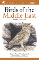
Vogelgids Birds of the Middle East - Midden Oosten | Bloomsbury
De beste vogelgids voor het Midden Oosten! Zeer uitgebereid met goede soortbeschrijvingen, verspreidingskaarten en gedetailleerde afbeeldingen. De Helm Field Guides zijn toonaangevend voor de betere vogelaars! The ultimate field guide to the birds of the Middle East, an indispensable companion for any traveller to the region.   The Middle East – the region stretching from Cyprus and the Levant to Iran, including Turkey and the Arabian Peninsula, plus Socotra – has a wonderfully broad and diverse avifauna, featuring a host of wintering and passage migrants, enigmatic breeders, and even a few endemics that occur nowhere else.   This authoritative book covers more than 895 species recorded in the Middle East, including details of all regular visitors and breeding species, from the Purple Sunbird to the Northern Bald Ibis. Featuring 180 stunning colour plates by three of the world's leading bird illustrators, this practical guide also includes concise species accounts describing key ident…
41,50
Wegenkaart - landkaart Africa - Afrika | National Geographic
  • Waterproof • Tear-Resistant • Reference Map   Expertly researched and designed, National Geographic's Africa Flags & Facts Map is the authoritative map of Africa by which other reference maps are measured. The map side includeds a political map showing countries, cities and other landmarks and a physical map shows the landforms such as mountain ranges and rivers.   Clearly defined boundaries, major cities, and physical features Hundreds of place names carefully placed to maintain legibility in heavily populated areas Includes Africa and adjacent regions within Europe and Asia Detailed physical map of Africa with mountain ranges, plains, lakes, and rivers Flags and facts with detailed information about cultural and physcial attributes Printed in the U.S.A. on extremely durable, waterproof, and tear-resistant material This Reference Map is printed on durable synthetic paper, making it waterproof, tear-resistant and tough — capable of withstanding the rigors of any kind of use in the…
17,50
Fietsgids the Bikepacker's Guide to the World | Lonely Planet
Take your bicycle on the ride of a lifetime with the help of The Bikepackers' Guide to the World. Discover 75 of the most amazing cycling routes in every continent and use the detailed maps, directions, accommodation and practical information to plan your trip. Lonely Planets experts tell you how to prepare, what to take, when and where to go. Bikepacking is the fast-growing adventure activity that gives people the freedom to discover the world in a sustainable and slow-paced fashion on their bicycles. The number of new purpose-built, long-distance cycling routes is increasing all the time and this comprehensive book selects the top 75 to add to your bicycling bucket list. Lonely Planet describes the route in step-by-step detail with a large, accurate map and elevation profile helping cyclists pick a route that suits their experience. The routes are graded from easy to challenging and cover a range of distances from a weekend to a month or more. The rides vary from easy-going rail tra…
34,95

Klanten-reviews van Kinderpuzzel GeoPuzzle Africa and the Middle East - Afrika en het Midden Oosten | GEOtoys

Er zijn nog geen beoordelingen voor dit productBen jij de eerste die een review plaatst?

Meer over Kinderpuzzel GeoPuzzle Africa and the Middle East - Afrika en het Midden Oosten | GEOtoys

Productomschrijving

Unieke, educatieve puzzel van Afrika en het Midden Oosten met 65 puzzelstukjes in landvormen.  Gemaakt van gerecycled materiaal en ontwikkeld voor kinderen vanaf 4 jaar.   GeoPuzzles are maps of the major continents, with pieces shaped like individual countries. By putting together a GeoPuzzle, children learn what countries look like, what their names are, and where they are in relation to one another. At 50-70 pieces, the puzzles are perfect for ages 4-12. Designed by an art professor, GeoPuzzles are generously sized, brightly colored, and each piece is large enough to be easily handled.   GeoPuzzle Africa has 65 pieces, and is a jumbo-sized 17 x 17 inches.

Verken gerelateerde categorieën

Webshop.nl maakt gebruik van cookies. Ga je verder op onze website, ga dan akkoord met het plaatsen van cookies en de verwerking van deze data door ons en vermelde partners.