Kaartentas Waterproof Map Case | Ordnance Survey

0
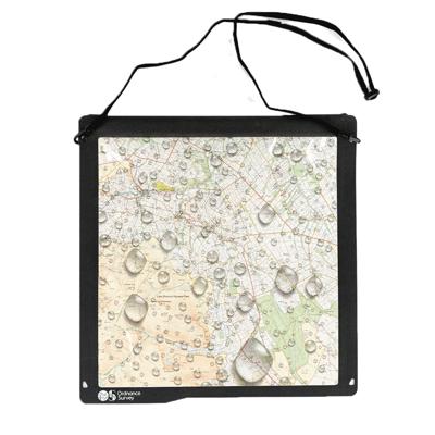
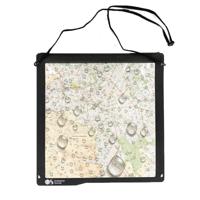
Our map cases are the perfect companion for your maps and other navigation aids. The case is made from a durable nylon fabric with a double sided touch friendly window, making viewing and protecting your maps & paperwork a doddle.   It’s waterproof up to 10 metres for 30 minutes, meaning it easily prevents water, sand, and dirt from getting in. In...

Verkopers met dit product

Verkoper
Bezorging
Prijs
DeZwerver.nl logo
DeZwerver.nl
2,95
39,95

Anderen bekeken ook

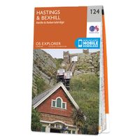
Wandelkaart - Topografische kaart 124 OS Explorer Map Hastings & Bexhill | Ordnance Survey
Experience the history-rich countryside where the High Weald, an Area of Outstanding Natural Beauty, sweeps down to the shore where the fate of Britain was decided in 1066. Explore Battle and visit the actual spot where the Battle of Hastings took place, now a beautiful wildflower meadow dotted with the ruins of a grand abbey built in penance for the slaughter.  Visit the seaside towns of Hastings and Bexhill with their medieval Old Towns, Victorian and Edwardian seafronts and pavilions  Glimpse wild deer and boar roaming in the forests near Robertsbridge and Dartwell Reservoir in the High Weald  Walk or cycle in the footsteps of William the Conqueror on the 1066 Path, or start the Saxon Shore Way from Hastings to head north to Winchelsea  Met zijn 4cm voor 1 km (2 ½ cm voor 1 mijl) schaal, is de OS Explorer kaartenserie de ideale en meest gedetailleerde kaartenreeks voor mensen die graag outdoor-activiteiten zoals fietsen, wandelen, paardrijden, klimmen en watersporten. Deze kaart…
19,50
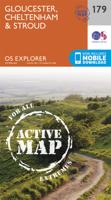
Wandelkaart - Topografische kaart 179 OS Explorer Map Gloucester, Cheltenham, Stroud | Ordnance Survey
The essential map for outdoor activities in Gloucester, Cheltenham and Stroud. The OS Explorer Map is the Ordnance Survey's most detailed folding map and is recommended for anyone enjoying outdoor activities including walking, horse riding and off-road cycling. This map now comes with a digital version which you can download to your smartphone or tablet.Providing complete GB coverage, the OS Explorer map series details information essential in the great outdoors, including youth hostels, pubs and visitor information. Rights of way, fences, permissive paths and bridleways are clearly shown, ensuring you have the best information to get the most out of your time in the countryside. FeaturesCotswold Way Severn Way Gloucestershire Way Macmillan Way Wysis WayCotswold Way (National Trail) GloucesterCheltenhamGloucester Stroud1:25 000 scale (4 cm to 1 km - 2.5 inches to 1 mile) Met zijn 4cm voor 1 km (2 ½ cm voor 1 mijl) schaal, is de OS Explorer kaartenserie de ideale en meest gedetailleerd…
19,50
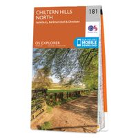
Wandelkaart - Topografische kaart 181 OS Explorer Map Chiltern Hills North | Ordnance Survey
The essential map for outdoor activities in Chiltern Hills North. The OS Explorer Map is the Ordnance Survey's most detailed folding map and is recommended for anyone enjoying outdoor activities including walking, horse riding and off-road cycling. This map now comes with a digital version which you can download to your smartphone or tablet.Providing complete GB coverage, the OS Explorer map series details information essential in the great outdoors, including youth hostels, pubs and visitor information. Rights of way, fences, permissive paths and bridleways are clearly shown, ensuring you have the best information to get the most out of your time in the countryside. FeaturesIcknield Way RidgewayNorth Buckinghamshire Way Icknield Way PathSwan's Way Two Ridges Link Aylesbury RingSouth Bucks Way Chess Valley Walk Chiltern Link Thame Valley WalkGrand Union Canal Walk Midshires Way Bledlow Circular Ride Hertfordshire Way Chiltern WayRidgeway (National Trail) Bedfordshire Buckinghamshire H…
19,50
Wandelkaart - Topografische kaart 162 OS Explorer Map Greenwich, Gravesend | Ordnance Survey
Consider yourself at home as you explore London's East End, a byword for cheeky Cockneys, gruesome murders and political activism. See the Thames in a new light in Greenwich, where you can stand on the Meridian Line at the Royal Observatory and climb aboard the Cutty Sark.    Explore the maritime town of Gravesend, visit a Cold War bunker  Uncover London's history as an Imperial trading hub at West India Docks, built in 1802  Walk and cycle along the London Loop through West Thurrock and Sidcup, and other recreational paths including the Thames Path National Trail through the heart of London Met zijn 4cm voor 1 km (2 ½ cm voor 1 mijl) schaal, is de OS Explorer kaartenserie de ideale en meest gedetailleerde kaartenreeks voor mensen die graag outdoor-activiteiten zoals fietsen, wandelen, paardrijden, klimmen en watersporten. Deze kaart is nog gedetailleerder dan de 'gewone' Landranger maps. Voor- en achterzijde bedrukt! Zeker op de moors en andere natuurgebieden van onschatbare waard…
19,50
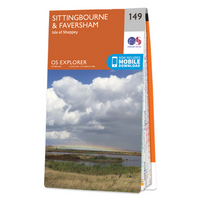
Wandelkaart - Topografische kaart 149 OS Explorer Map Sittingbourne, Faversham | Ordnance Survey
Explore the serene Isle of Sheppey and follow the Saxon Shore Way to discover the towns of Sittingbourne and Faversham. Further inland, the Kent Downs – an Area of Outstanding Natural Beauty – are beckoning.  Sail, kayak, fly kites or just relax on the sandy and pebbled beaches of Sheppey, or go birdwatching at the Swale National Nature Reserve  Discover Faversham, home of Britain’s oldest brewer and nearby Oare Gunpowder Works Country Park, where gunpowder was manufactured for the battles of Trafalgar and Waterloo  Walk, ramble or cycle along the Saxon Shore Way through Faversham and Sittingbourne, or head inland to the North Downs Way, a National Trail Met zijn 4cm voor 1 km (2 ½ cm voor 1 mijl) schaal, is de OS Explorer kaartenserie de ideale en meest gedetailleerde kaartenreeks voor mensen die graag outdoor-activiteiten zoals fietsen, wandelen, paardrijden, klimmen en watersporten. Deze kaart is nog gedetailleerder dan de 'gewone' Landranger maps. Voor- en achterzijde bedrukt! …
19,50
Wandelkaart - Topografische kaart 163 OS Explorer Map Gravesend, Rochester | Ordnance Survey
Immerse yourself in Gravesend with its maritime history, Charles Dickens links and even a Cold War bunker! Contrast the medieval magnificence of Rochester where the cathedra was founded in 604 and the imposing Rochester Castle keeps watch over the Medway crossing.   Explore the Hoo Peninsula and the North Kent marshes that inspired Charles Dickens to write Great Expectations Discover the Medway towns of Chatham and Gillingham, home to the Historic Dockyard Chatham and the Royal Engineers Museum Walk and cycle along the Saxon Shore Way and other popular recreational paths including the Wealdway and North Downs Way Met zijn 4cm voor 1 km (2 ½ cm voor 1 mijl) schaal, is de OS Explorer kaartenserie de ideale en meest gedetailleerde kaartenreeks voor mensen die graag outdoor-activiteiten zoals fietsen, wandelen, paardrijden, klimmen en watersporten. Deze kaart is nog gedetailleerder dan de 'gewone' Landranger maps. Voor- en achterzijde bedrukt! Zeker op de moors en andere natuurgebieden…
19,50
Wandelkaart - Topografische kaart 159 OS Explorer Map Reading, Wokingham & Pangbourne Map | Thames Path | Ordnance Survey
Experience everything Reading has to offer and discover the charms of Wokingham and of Pangbourne, an idyllic waterside town on the River Thames among the gorgeous North Wessex Downs. Follow the Thames Path through Pangbourne and Reading where it skirts the evocative, 900-year-old ruins of Reading Abbey.     Visit Basildon Park, immortalised in Pride & Prejudice, and neighbouring Beale Wildlife Park for a wilder experience  Swim in the Thames Lido or visit the award-winning, much-loved Museum of English Rural Life (MERL)  Walk, hike or cycle along this peaceful stretch of the Thames Path or other recreational paths including the Blackwater Valley Path Met zijn 4cm voor 1 km (2 ½ cm voor 1 mijl) schaal, is de OS Explorer kaartenserie de ideale en meest gedetailleerde kaartenreeks voor mensen die graag outdoor-activiteiten zoals fietsen, wandelen, paardrijden, klimmen en watersporten. Deze kaart is nog gedetailleerder dan de 'gewone' Landranger maps. Voor- en achterzijde bedrukt! Zek…
19,50
Nieuw
Wandelkaart - Topografische kaart 179 OS Explorer Map | Active Gloucester / Cheltenham / Stroud | Ordnance Survey
The essential map for outdoor activities in Gloucester, Cheltenham and Stroud. The OS Explorer Map is the Ordnance Survey's most detailed folding map and is recommended for anyone enjoying outdoor activities including walking, horse riding and off-road cycling. This map now comes with a digital version which you can download to your smartphone or tablet.Providing complete GB coverage, the OS Explorer map series details information essential in the great outdoors, including youth hostels, pubs and visitor information. Rights of way, fences, permissive paths and bridleways are clearly shown, ensuring you have the best information to get the most out of your time in the countryside. FeaturesCotswold Way Severn Way Gloucestershire Way Macmillan Way Wysis WayCotswold Way (National Trail) GloucesterCheltenhamGloucester Stroud1:25 000 scale (4 cm to 1 km - 2.5 inches to 1 mile)   Met zijn 4cm voor 1 km (2 ½ cm voor 1 mijl) schaal, is de OS Explorer kaartenserie de ideale en meest gedetaillee…
25,95
Nieuw
Wandelkaart - Topografische kaart 181 OS Explorer Map | Active Chiltern Hills North | Ordnance Survey
The essential map for outdoor activities in Chiltern Hills North. The OS Explorer Map is the Ordnance Survey's most detailed folding map and is recommended for anyone enjoying outdoor activities including walking, horse riding and off-road cycling. This map now comes with a digital version which you can download to your smartphone or tablet.Providing complete GB coverage, the OS Explorer map series details information essential in the great outdoors, including youth hostels, pubs and visitor information. Rights of way, fences, permissive paths and bridleways are clearly shown, ensuring you have the best information to get the most out of your time in the countryside. FeaturesIcknield Way RidgewayNorth Buckinghamshire Way Icknield Way PathSwan's Way Two Ridges Link Aylesbury RingSouth Bucks Way Chess Valley Walk Chiltern Link Thame Valley WalkGrand Union Canal Walk Midshires Way Bledlow Circular Ride Hertfordshire Way Chiltern WayRidgeway (National Trail) Bedfordshire Buckinghamshire H…
25,95
Wandelkaart - Topografische kaart 148 OS Explorer Map Maidstone, Medway Towns | Ordnance Survey
Walk a beautiful stretch of the North Downs Way offering spectacular views of the Kent Downs, Medway Valley and towards the Channel. Discover Kentish villages with their distinctive oast-house chimneys, vineyards on sunny slopes and romantic ruins as you head towards Rochester and its imposing castle guarding the road to London.    Visit the Historic Dockyard Chatham, a beautifully-preserved relic of the Age of Sail home to three historic warships and much more  Travel back in time at Leeds Castle near Maidstone, described as ‘the loveliest castle in the world’, or even further back at the megalithic dolmen known as Kit’s Coty  Walk, hike or cycle along the North Downs Way and other recreational maps including the Medway Valley Walk and Wealdway Met zijn 4cm voor 1 km (2 ½ cm voor 1 mijl) schaal, is de OS Explorer kaartenserie de ideale en meest gedetailleerde kaartenreeks voor mensen die graag outdoor-activiteiten zoals fietsen, wandelen, paardrijden, klimmen en watersporten. Deze…
19,50

Klanten-reviews van Kaartentas Waterproof Map Case | Ordnance Survey

Er zijn nog geen beoordelingen voor dit productBen jij de eerste die een review plaatst?

Meer over Kaartentas Waterproof Map Case | Ordnance Survey

Productomschrijving

Our map cases are the perfect companion for your maps and other navigation aids. The case is made from a durable nylon fabric with a double sided touch friendly window, making viewing and protecting your maps & paperwork a doddle.   It’s waterproof up to 10 metres for 30 minutes, meaning it easily prevents water, sand, and dirt from getting in. Insert your belongings into the case and have peace of mind knowing that they’re safe and secure. The four lash points mean it can be easily worn around your neck with a lanyard or secured to your gear.   Inside the border dimensions are 28x28cm / 11x11 inches. Total product dimensions 33x33cm.  
  • Waterproof fabric with welded seems
  • Zip lock plus hoop and double closure seal
  • Waterproof up to 10 metres for 30 minutes
  • Crystal clear touch friendly window, can easily be used with a tablet
  • Ideal for OS maps prints, tickets and other valuables


Verken gerelateerde categorieën

Webshop.nl maakt gebruik van cookies. Ga je verder op onze website, ga dan akkoord met het plaatsen van cookies en de verwerking van deze data door ons en vermelde partners.