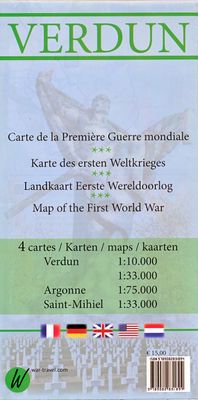
Historische Kaart Verdun - Eerste Wereldoorlog | War travel

0
Themakaart over de geschiedenis van de Eerste Wereldoorlog in en rond Verdun. Met gedetailleerde inzetten van Verdun, Argonne en Saint-Michel. Aandacht voor monumenten, musea, vestingen, loopgraven en kerkhoven.  Mooi kleurgebruik, veel detail en heel gedetailleerd. Gedrukt op stone-paper, dat gaat echt veel langer mee.   Van de uitgever Discover ...

Verkopers met dit product

Webshop
Bezorging
Prijs
DeZwerver.nl logo
DeZwerver.nl
niet bekend
15,-

Anderen bekeken ook

Historische Kaart 14 - 18 Map of Verdun (Battlefield map) | Eerste Wereld Oorlog | Pen and Sword publications
Comprehensive mapping for the Battle of Verdun 1916 and a sizable part of the early days of the Meuse-Argonne Offensive 1918. Clearly produced in full color, with different types of feature in different colors, all supported by two comprehensive keys. For many years the Holts have provided tourers to the battlefields with excellent mapping for the Ypres Salient and the Somme. This map of the Verdun/Meuse area fills one of the many gaps in the coverage of the Western Front. This map of the Verdun battlefield is in the same style, using a color coded system to distinguish the different types of features. It includes some 300 locations of memorials, cemeteries, significant remnants of the battle terrain, remaining fortifications, trenches, the destroyed villages and other vestiges of the war. On the reverse there is a cut out and enlarged section of the Verdun battlefield in particular - the most visited part of the area, which provides greater detail. This section includes the Ossuary…
9,95
Reisgids World War 1 north east - Eerste Wereldoorlog | War travel
Marne - Argonne - Maas - Verdun - Les Eparges - Saint Mihiel - Vogezen   Een zeer uitgebreide, royaal van foto's voorziene reisgids langs de 'bezienswaardigheden' van de 1e Wereldoorlog. Goede beschrijvingen en uitstekende kaarten waarmee je deze plekken kunt terugvinden in het veld.    World War 1, also known as the Great War or ‘The War to End All Wars’, lasted from July 28, 1914 to November 11, 1918. The world was caught up in a global conflict and Europe endured four years of horrific fighting. The landscape is still marked with mine and artillery craters, trenches, cemeteries and forts still mark the landscape. Numerous memorials honor the dead and museums exhibit vestiges of a time that should never be forgotten. This illustrated travel guide describes these sites, which are located in the northeast of France between Reims and the Swiss border, an area which saw some of the bloodiest battles of the war. Meer informatie   With the use of detailed maps, GPS coordinates and address…
21,50
Historische Kaart Major & Mrs Holt's Battle Map of Market Garden | Pen and Sword publications
This is the only map of its kind devised and created by Major and Mrs Holt and is used by many guides   It shows the locations of 300 memorials and war cemeteries over THE WHOLE OPERATION MARKET-GARDEN AREA   It shows the progress of the battle from Leopoldsburg to  Eindhoven, Nijmegen, Arnhem and Oosterbeek overlaid on modern roads   In four colours, double sided and with 10 inset maps it shows all drop and landing zones   Suitable for navigation by car, bicycle or foot   Size - The map measures 19.5 inches (49cm) by 28 inches (71cm). It is printed in four colours and is on firm glossy paper.   On one side at a scale of 1:180,000 is shown the whole of the Market Garden corridor of operations from Arnhem in the north to Leopoldsburg in the south and from Vught in the west to Overloon in the east. See below for details of the other side.   What is Marked on the Map   This map is quite unique and no other exists that shows the Market Garden Corridor in such detail. Over 230 memor…
9,95
Reisgids 1e Wereldoorlog - World War I Battlefields | Bradt Travel Guides
Thoroughly updated for this new 3rd edition, Bradt's World War I Battlefields remains the only compact practical travel guide to cover both French and Belgian battlefield sites involved in one of the deadliest conflicts in human history, which changed the face of foreign policy and European geography forever. The 2014-18 centenary of the First World War was a huge catalyst for battlefield tourism, leading to a proliferation of innovative new museums, memorials, commemorative trails, statues and more - which are comprehensively covered in this update. Co-authored by two award-winning travel writers, this lightweight and pocket-friendly guidebook is perfect for visitors. It covers all the main sites, memorials and museums of the entire Western Front alongside practical information such as travelling there and getting around, and how to book the best guided tours.   In the Belgian section of the book, chapters cover Ypres and the Ypres Salient; Poperinge and Heuvelland; Diksmuide, Veurne…
13,95
Historische Kaart Exploring the World Heritage Site - Stonehenge and Avebury | English Heritage
The Stonehenge and Avebury World Heritage Site is internationally important for its outstanding prehistoric monuments. Stonehenge is the most architecturally sophisticated prehistoric stone circle in the world, while Avebury is the largest. Around them lie numerous other monuments and sites, which demonstrate over 2,000 years of continuous use. Together they form a unique prehistoric landscape. There is no better way to learn about an experience the monuments than to go out and explore the World Heritage Site on foot. This map is ideal for walkers and others wishing to explore the fascinating landscape of the two areas of the World Heritage Site. The map uses an Ordnance Survey 1:10,000 base and draws upon information from the English Heritage Archive and recent archaeological investigations. With Stonehenge on one side and Avebury on the other, the map shows and describes both visible and hidden remains, with information about where you can find out more. The map is divided into two …
14,95
Reisgids Ypres Salient - Ieper en omgeving | War travel
Een zeer uitgebreide, royaal van foto's voorziene reisgids langs de 'bezienswaardigheden' van de 1e Wereldoorlog. Goede beschrijvingen en uitstekende kaarten waarmee je deze plekken kunt terugvinden in het veld.    World War 1, also known as the Great War or ‘The War to End All Wars’, lasted from July 28, 1914 to November 11, 1918. The world was caught up in a global conflict and Europe endured four years of horrific fighting. The landscape is still marked with mine and artillery craters, trenches, cemeteries and forts still mark the landscape. Numerous memorials honor the dead and museums exhibit vestiges of a time that should never be forgotten. This illustrated travel guide describes these sites, which are located in and around Ypres - Ieper, which is known as Ypres Salient. Many battles were fought in this region.    Detailed map GPS coordinates addresses
17,50
Historische Kaart An Archaeological Map of Hadrian's Wall | English Heritage
It was more than just a wall: it was a whole military zone designed to control movement across the northern frontier of the Roman province of Britannia. Great earthwork barriers survive, along with the remains of forts and temporary camps; watch-towers and fortified gates; civilian settlements, temples, cemeteries, bath-houses, roads and bridges. Stretching across the spine of England from the North-East coast to the Irish Sea, the line of the frontier extends for over 100 miles through every type of landscape: from the streets of urban Tyneside, through arable fields; along the crags of the wild Whin Sill; to the sands of the Solway, and down the coast of Cumbria. Drawing upon the extensive expertise and unrivalled archives of English Heritage, and those of its partners, this map depicts the fruits of modern archaeological research: in field survey, geophysics, excavation, and the analysis of aerial photographs. Using Ordnance Survey 1:25,000 data - the ideal scale for walkers - this…
14,95
Historische Kaart Major & Mrs Holt's Battle Map of The Somme | Pen and Sword publications
This is the only map available that shows the exact locations of 300 memorials and places of interest on the battlefields of the Somme   This Sixth Edition also covers the American and Canadian areas between Amiens and Montdidier.    It is double sided in four colours with an overall view on one side and a detailed view on the other, both showing battle lines and ORBAT information   There are detailed alphabetical and thematic indexes to all 300 points.   Size - The map measures 19.5 inches (49cm) by 28 inches (71cm). It is printed in four colours and is double sided on firm glossy paper.   On one side at a scale of 1:70,000 is shown the whole of the Somme battle area from Bullecourt in the north to Amiens in the south and from Doullens in the west to Pyronne in the east. Also on this side are the colour coded indexes and the map of the 1918 sector from Villers Bretonneux to Cantigny.   On the other side at a scale of 1:40,000 the battle area mostly, but not exclusively, associat…
9,95
Reisgids Virginia including Washington DC | Moon Travel Guides
De Amerikaanse uitgever Moon is een vergelijkbare gids met uitgever Lonely Planet > veel praktische informatie met veel diepgang! Het feit dat het een Amerikaanse uitgever is, maken deze gidsen zeer aantrekkelijk voor de staten afzonderlijk. De Lonely Planet haalt dat nivo niet! From metropolitan cities and misty mountains to colorful coastline and charming small towns, journey through the Old Dominion state with Moon Virginia. Inside you'll find:* Flexible itineraries, such as five days visiting Virginia's battlefields and breweries and ten days exploring the whole state, with detailed coverage of Washington DC* The best road trips in Virginia, including the scenic Skyline Drive and the Blue Ridge Parkway* Strategic advice for history buffs, foodies, outdoor adventurers, families, and more* Can't-miss sights and unique experiences: Visit Revolutionary War battlefields and hear the stories behind Civil War landmarks or immerse yourself in history in Colonial Williamsburg. Stroll the V…
20,95
Fotoboek World War II Battlefields - 2e Wereldoorlog | Amber Books
Featuring battlefield sites divided by wartime theater, World War II Battlefields allows the reader to explore well-known battle locations today and compare them to images captured during the height of the conflict. Examine the huge concrete bunker at Fort Eben Emael, Belgium, captured by German glider troops in May 1940 and still intact today. See the beaches at Tarawa atoll, a scene of fierce fighting between the US Marines and the Japanese defenders in 1943, or the streets of the Ukrainian city of Kharkiv, the center of a bloody battle between the II SS Panzer Korps and the Red Army. Explore the Norman village of Villers-Bocage, where a few German Tiger tanks halted the advance of the British 7th Armoured Division a week after the D-Day landings. Visit the twin medieval towers of the bridge at Remagen on the Rhine river, made famous in photos and movies, or the dozens of Japanese ships sunk in Truk Lagoon following comprehensive American air attacks, and today a popular dive site.…
27,95

Klanten-reviews van Historische Kaart Verdun - Eerste Wereldoorlog | War travel

Er zijn nog geen beoordelingen voor dit productBen jij de eerste die een review plaatst?

Meer over Historische Kaart Verdun - Eerste Wereldoorlog | War travel

Productomschrijving

Themakaart over de geschiedenis van de Eerste Wereldoorlog in en rond Verdun. Met gedetailleerde inzetten van Verdun, Argonne en Saint-Michel. Aandacht voor monumenten, musea, vestingen, loopgraven en kerkhoven. 

Mooi kleurgebruik, veel detail en heel gedetailleerd. Gedrukt op stone-paper, dat gaat echt veel langer mee.


Van de uitgever

Discover Verdun and its surroundings. This double-sided printed map shows the locations of cemeteries, monuments, forts, trenches and museums in and around Verdun. The map is printed on Stone Paper, 100% water-repellent, very durable in use and paper-free. Folded size 12.5 * 25 cm, unfolded 70 * 100 cm.   Discover 10 destroyed villages, 66 World War I cemeteries (37 French, 28 German and 1 American), 30 fortresses, 40 monuments, 16 trenches and 10 World War I museums using this highly detailed map.   The map is divided into 4 sections:   The city of Verdun. Visit the underground Citadelle, the beautiful Victory Monument, the old town in Vauban style and the old cathedral.   The Argonne, the area west of Verdun, is home to many sights from the First World War. Discover the trench systems and the remains of mine battles (underground battles with heavy explosives), many First World War cemeteries and ossuaries. The Americans fought a heavy battle here in 1918 and the largest American military cemetery in Europe is located here.   The well-known area east of Verdun, the red square, where the exhausting battle of Verdun was fought. discover the destroyed villages, the forts and bunkers, trenches, the Ossuaire Douaumont with the remains of 130,000 soldiers and the beautiful Memorial Verdun museum.   Saint-Mihiel, south of Verdun, is often forgotten but is home to very well-preserved trenches and beautiful monuments. Visit the imposing American monument of Montsec or the trenches so close together that the German and French/American could throw hand grenades at each other.    

Verken gerelateerde categorieën

Webshop.nl maakt gebruik van cookies. Ga je verder op onze website, ga dan akkoord met het plaatsen van cookies en de verwerking van deze data door ons en vermelde partners.