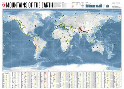
Wereldkaart Mountains of the Earth | Bergen van de Wereld | 140 x 100 cm | Marmota Maps

0
Mountains of the Earth invites you to discover the fascinating summits of our planet. We show Earth's highest peaks in the Himalaya, impressive country high points such as Fuji-san in Japan, mountains of great historic importance like Mount Olympus, particularly beautiful landmarks like the Table Mountain or the Matterhorn, and some of the world's...

Verkopers met dit product

Webshop
Bezorging
Prijs
DeZwerver.nl logo
DeZwerver.nl
niet bekend
74,95

Anderen bekeken ook

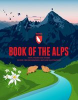
Reisinspiratieboek - Reisboek Book of the Alps | Marmota Maps
The Book of the Alps  the great illustrated book about the Alps.290 pages with over 1000 illustrations, graphics, and maps on geography, sports, history, culture, climate, environment and much more. Understand the Alps like never before.Created in cooperation with the Alpine clubs of Germany, Austria, and South Tyrol. CONTENTS The Book of the Alps has 46 chapters in seven subject areas: Geography   Flora and Fauna   Climate and Environment    Alpinism   Mountain Sports   Society and Economy   Arts and Culture   GEOGRAPHY Geological Formation Ice Age Mountains Valleys Mountain Passes Lakes and Rivers Glaciers The Alps are unique. How did they form and evolve? How do glaciers, passes, valleys, lakes, and rivers shape the landscape? Answers to these and many more questions can be found in the geography chapter.   FLORA AND FAUNA Biodiversity Plants Forests Animals National Parks The Alpine environment is fascinating. Alpine flowers such as the edelweiss and Alpine anima…
44,95
Wegenkaart - landkaart Jasper National Park (Alberta) | Gem Trek Maps
Waterproof and tear-resistant map for Jasper National Park in the Canadian Rockies.   Whether you are a first-time visitor or a long-time local, you’ll find Gem Trek’s Jasper National Park Map to be an invaluable tool. Researched and designed by locals, and printed in Canada, this map features accurate cartography and subtly colored relief that puts the mountainous region in perspective. The map is printed on high-quality synthetic waterproof paper that can be folded and refolded hundreds of times.   The 1:250,000 scale is ideal for discovering the very best of Jasper National Park. Highlights and our recommended hiking trails are marked by numbered stars, then cross-referenced on the reverse side with descriptions. Also included are all mountains and their elevations, along with natural features such as waterfalls, hot springs, and glaciers.   In addition to descriptions for the top highlights and most popular hiking trails, the reverse side has inset maps for the town of Jasp…
16,95
Wereldkaart 09 Natuurkundig - the world physical, 178 x 122 cm | National Geographic
Bijzonder fraaie natuurkundige kaart van National Geographic waarbij het accent ligt op de fysische aspecten van de aarde met veel details van de oceanen. Een schoonheid aan de muur! Deze versie is geplastificeerd.   Our World Physical - Ocean Floor map highlights the Earth's land and undersea forms with exquisite hand-painted relief. Drawn in the Winkel Tripel projection to minimize distortion of the landforms. Two corner inset maps show the Earth's crust and world climatic zones. Scale: 1:24,031,000.  Superb representation of the ocean floor makes this 175.5 x 121.5cm (5ft 9” x 4ft approx.) physical map of the world one of the most interesting titles in the National Geographic Society’s long list of wall maps. Drawn with great skill to achieve a 3-D effect, ocean floor plains, basins, continental shelves, trenches, ridges and fractures are shown with their names, indicating in many places their depth in metres.    On land masses relief shading shows the mountain chains, whilst the c…
74,95
Wereldkaart Natuurkundig, oceaanbodem, 116 x 77 cm | National Geographic
Bijzonder fraaie natuurkundige kaart van National Geographic waarbij het accent ligt op de fysische aspecten van de aarde met veel details van de oceanen. Een schoonheid aan de muur!   Our World Physical - Ocean Floor map highlights the Earth's land and undersea forms with exquisite hand-painted relief. Drawn in the Winkel Tripel projection to minimize distortion of the landforms. Two corner inset maps show the Earth's crust and world climatic zones   .Superb representation of the ocean floor makes this physical map of the world one of the most interesting titles in the National Geographic Society’s long list of wall maps. Drawn with great skill to achieve a 3-D effect, ocean floor plains, basins, continental shelves, trenches, ridges and fractures are shown with their names, indicating in many places their depth in metres.   On land masses relief shading shows the mountain chains, whilst the colouring indicates different types of terrain: arid regions, vegetation, tundra, etc. The ma…
36,95
Nieuw
Wandelkaart 01 Jasper National Park & Maligne Lake | Gem Trek Maps
Scheur- en Watervast papier Gem Trek’s JASPER AND MALIGNE LAKE MAP map is designed for outdoor enthusiasts looking to explore the section of Jasper National Park near the town and out to Maligne Lake. Whether you are touring along the roads or heading into the backcountry, you’ll find the waterproof and tear-resistant Jasper & Maligne Lake Map to be an invaluable tool.   This map features detailed cartography, accurate hiking trails with distances, and details such as campgrounds, equestrian routes, picnic areas, and fire lookouts. On the back of the map are trail descriptions and photos of 18 recommended day hikes, four overnight or multi-day trips, and six classic mountain bike rides. Each of these described trails is referenced and colour-coded to the map on the front. Also on the back is contact information for Jasper National Park, as well for as the three backcountry lodges located in the Tonquin Valley and on the Skyline Trail.   Jasper & Maligne Lake Map Coverage The Jas…
16,95
Nieuw
Wandelkaart - Topografische kaart 201 Trails Illustrated Yellowstone National Park | National Geographic
Prachtige geplastificeerde kaart van het bekende nationaal park. Met alle recreatieve voorzieningen als campsites, maar ook met topografische details en wandelroutes ed. Door uitgekiend kleurgebruik zeer prettig in gebruik. Scheur en watervast! National Geographic's Trails Illustrated map of Yellowstone National Park is designed to meet the needs of outdoor enthusiasts by combining valuable information with unmatched detail of America's first national park. Expertly researched and created in partnership with local land management agencies, this map features key points of interest including Mammoth Hot Springs, Canyon Village, Yellowstone Lake, Yellowstone Falls, Grant Village, and Old Faithful geyser area.   With over 1,000 miles of mapped trails, the Yellowstone National Park map can guide you off the beaten path and back again. The clearly marked trails include mileages between intersections. Trail summaries provide elevation, duration, and difficulty for a variety of suggested hike…
16,95
Wandelgids Tour of the Ecrins National Park GR54 | Knife Edge Outdoor
Overzichtelijke routegids van deze prachtige wandelroute. Per etappe vind je een hoogteprofiel, goede beschrijvingen van de wandelroute, een topografische kaart op gedetailleerde schaal. Voor en achterin de gids staat aanvullende praktische informatie zoals adressen van campings, andere accommodaties en bijvoorbeeld een paar pagina's over de flora en fauna.  The Tour of the Ecrins National Park is also known as the GR54. It is arguably the best trek in the Alps. It is an incredible walk of 193km (120 miles) around the incomparable Ecrins National Park in the Southern French Alps. It takes  9-12 days. On the way, 14 magnificent mountain passes are crossed. It is almost certainly the finest trek that you have never heard of! The Ecrins Massif is the second highest range of mountains in the French Alps: the Mont Blanc Massif is of course the highest.   Unspoilt and remote high mountain terrain: snow frosted summits, beautiful valleys and pastures, sparkling azure lakes, carpets of wil…
26,95
Wandelkaart Tour & Trail Costa Blanca mountains | Discovery Walking Guides
Thanks to all the walking research carried out by Charles Davis for his new Walk! the Costa Blanca Mountains guide book plus gps ground surveys carried out by David & Ros Brawn we have been able to a new Costa Blanca Mountains Tour & Trail Super-Durable Map. This new Costa Blanca Mountains Tour & Trail Super-Durable Map is the essential purchase for everyone looking to explore the exciting mountainous hinterland on the Costa Blanca. Whether you are exploring on foot, bike or horse this is your first choice map for accurate navigation on roads and as soon as you leave the tarmac. Scale 1:40,000 2.5cms = 1km. Map size; double-sided 780mm by 600mm folded to 21cm by 12cm. Roads; Motorway, major roads, secondary roads, minor roads & tarmacked lanes including latest road numbering system. Tracks & Trails; Unsurfaced (dirt) roads and walking trails. Heights; 100 & 20 metre contours, height & trig points in metres, height background colours in 200 metre colour bands. UTM 1km Grid with WGS84 D…
15,95
Wandelkaart Tatry Zachodnie | Sygnatura
Goede wandelkaart van het grote westelijke deel van het Tatra gebergte, zowel aan de Poolse als aan de SLowaakse kant. Wandelpaden, campings, hutten, alles staat er op.  Western Tatra Mountains in Poland and Slovakia at 1:25,000 on a contoured and GPS compatible map from CartoMedia highlighting waymarked hiking trails, mountain huts and campsites, places of interest, etc, Coverage extends from Zakopane westwards to Habovka. On the reverse are panels with an overview of the waymarked hiking trails for planning longer routes, a road map showing access to this part of the Tatra Mountains from both sides of the border, a directory of local mountain huts and other useful tourist information, etc.   Maps in the Cartomedia hiking series present topography is by contours at 20m intervals, enhanced by relief shading and, where appropriate, graphic relief for exposed rocky areas. Waymarked hiking trails indicate approximate walking times in both directions and possible danger points. Most title…
9,95
Fotoboek Alpenglow - The Finest Climbs on the 4000m Peaks of the Alps | Benn Tibbetts
ALPENGLOW takes the reader through a journey of personal adventure, immersive art and breathtaking scenery, combining inspiration with detailed local knowledge. Climbing the 4000m peaks of the Alps is one of the great and enduring challenges in mountaineering. It is a project that requires endurance, courage, skill, and humility.   Whether you are a lover of mountain landscapes, an aspiring alpinist, or already a veteran of many adventures, this book will provide a wealth of original and inspiring material to help with planning future excursions or simply immersing yourself in the beauty of the high mountain   Drawings The photography in the book is matched by a series of finely wrought pencil drawings. Several of these are available as luxury prints to complement the book.   Finsteraarhorn pencil drawing (12 x 8 cm) example   The drawings for this project are usually smaller than a typical postcard. Each one is based on photographs and made with finely-sharpened pencils whilst…
72,95

Klanten-reviews van Wereldkaart Mountains of the Earth | Bergen van de Wereld | 140 x 100 cm | Marmota Maps

Er zijn nog geen beoordelingen voor dit productBen jij de eerste die een review plaatst?

Meer over Wereldkaart Mountains of the Earth | Bergen van de Wereld | 140 x 100 cm | Marmota Maps

Productomschrijving

Mountains of the Earth invites you to discover the fascinating summits of our planet. We show Earth's highest peaks in the Himalaya, impressive country high points such as Fuji-san in Japan, mountains of great historic importance like Mount Olympus, particularly beautiful landmarks like the Table Mountain or the Matterhorn, and some of the world's most remote and rarely known summits in Siberia, Greenland, or Antarctica.   Information on every mountain We show each mountain's height and prominence, as well as the country or countries it lies in. The altitude bar for each mountain is color-coded, same as the mountain icons on the map. This makes it easy, for instance, to find Earth's 14 8000ers in the list. The Seven (Second / Third) Summits are highlighted, as well as country high points. We also mark mountains of historic importance and particularly beautiful and iconic mountains as landmarks.   Mountain icons on the map  The mountains on our map reveal much more than just their name and location. The color of each icon indicates the mountain's altitude. The mountain symbol shows you if the mountain is an ultra-prominent peak, and underlined mountain names indicate country high points.


Verken gerelateerde categorieën

Webshop.nl maakt gebruik van cookies. Ga je verder op onze website, ga dan akkoord met het plaatsen van cookies en de verwerking van deze data door ons en vermelde partners.