webshop.nl
Categorieën
  Sluiten

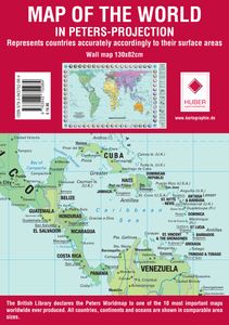
Wereldkaart Map of the world in Peters-Projection 130 x 82 cm - Engels | Huber Verlag

Represents countries accurately accordingly to their surfice areas. The british Library declares the Peter Projection Worldmap to one one the most important maps worldwide ever produced. All countries, continents, and oceans are shown in comparable area sizes....
34,-

Webshops met dit product

Webshop
Bezorging
Prijs

Anderen bekeken ook

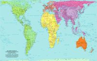
Wereldkaart Peters Projection - Peters Projectie 130 x 82 cm | Huber Verlag
Een bijzondere wereldkaart die gebruik maakt van de Peters Projectie. Hierdoor worden de oppervlaktes correct weergegeven op de kaart. Bekijk de wereld anders!  De landen van de aarde in gebiedsbrede weergave. Peters projectie 1: 63.060 gerolde kaart Formaat: 82,5 x 129,5 cm Schaal: 1: 630 609 475 Arno Peters, een historicus uit Bremen, ontwikkelde voor onze tijd een nieuwe wereldkaart. Trouw aan schaal in gebied, as en positie, reproduceert het nauwkeurig de verhoudingen van de noordelijke en zuidelijke hemisferen. De Peters-wereldkaart is een verfrissende afwijking van de verouderde Eurocentrische kijk die onze kijk op de wereld al 400 jaar beïnvloedt. De Peters-kaart toont elk land in zijn werkelijke gebiedsgrootte en op een direct vergelijkbare basis. The Fidelity Pojection is gebaseerd op het decimale gradennetwerk gecreëerd door Arno Peters. Het verdeelt het aardoppervlak - waarbij de 0-merdian op de gecorrigeerde datumlijn wordt geplaatst - in 100 velden met gelijke breedte en 1…
34,-
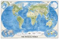
Wereldkaart 09 Natuurkundig - the world physical, 178 x 122 cm | National Geographic
Bijzonder fraaie natuurkundige kaart van National Geographic waarbij het accent ligt op de fysische aspecten van de aarde met veel details van de oceanen. Een schoonheid aan de muur! Deze versie is geplastificeerd.   Our World Physical - Ocean Floor map highlights the Earth's land and undersea forms with exquisite hand-painted relief. Drawn in the Winkel Tripel projection to minimize distortion of the landforms. Two corner inset maps show the Earth's crust and world climatic zones. Scale: 1:24,031,000.  Superb representation of the ocean floor makes this 175.5 x 121.5cm (5ft 9” x 4ft approx.) physical map of the world one of the most interesting titles in the National Geographic Society’s long list of wall maps. Drawn with great skill to achieve a 3-D effect, ocean floor plains, basins, continental shelves, trenches, ridges and fractures are shown with their names, indicating in many places their depth in metres.    On land masses relief shading shows the mountain chains, whilst the co…
74,95
Wereldkaart 08 Natuurkundig - the world physical, 178 x 122 cm | National Geographic
Bijzonder fraaie natuurkundige kaart van National Geographic waarbij het accent ligt op de fysische aspecten van de aarde met veel details van de oceanen. Een schoonheid aan de muur! Our World Physical - Ocean Floor map highlights the Earth's land and undersea forms with exquisite hand-painted relief. Drawn in the Winkel Tripel projection to minimize distortion of the landforms. Two corner inset maps show the Earth's crust and world climatic zones. Scale: 1:24,031,000. Superb representation of the ocean floor makes this 175.5 x 121.5cm (5ft 9” x 4ft approx.) physical map of the world one of the most interesting titles in the National Geographic Society’s long list of wall maps. Drawn with great skill to achieve a 3-D effect, ocean floor plains, basins, continental shelves, trenches, ridges and fractures are shown with their names, indicating in many places their depth in metres. On land masses relief shading shows the mountain chains, whilst the colouring indicates different types of t…
52,95
Reisgids - Fotoboek Epic Hikes of the World | Lonely Planet
With stories of 50 incredible hiking routes in 30 countries, from New Zealand to Peru, plus a further 150 suggestions, Lonely Planet's Epic Hikes of the World will inspire a lifetime of adventure on foot. From one-day jaunts and urban trails to month-long thru-hikes, cultural rambles and mountain expeditions, each journey shares one defining feature: being truly epic. In this follow-up to Epic Bike Rides and Epic Drives, we share our adventures on the world's best treks and trails. Epic Hikes is organised by continent, with each route brought to life by a first-person account, beautiful photographs and charming illustrated maps. Additionally, each hike includes trip planning advice on how to get there, where to stay, what to pack and where to eat, as well as recommendations for three similar hikes in other regions of the world. Hikes featured include: Africa & the Middle East: Cape Town's Three Peaks (South Africa) Kilimanjaro (Tanzania) Camp to Camp in South Luangwa National Park (…
21,95
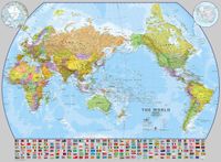
Wereldkaart World pacific-centred wall map, 136 x 100 cm | Maps International
View the world from a different perspective with Maps International's Pacific centred world wall map with flags.    Map details: This Pacific centred wall map shows the world centred along the 150° line of longitude. Instead of parting the map along the Pacific Ocean (as most world wall maps are), this one parts the map along the Atlantic Ocean meaning Europe and the Americas are in separate sides of the map!    Pacific centred world wall map has countries marked in different colours according to international country boundaries. Capital cities (including approximate population size) and hill shading are also shown. Mountain peaks and depths are given on this Pacific centred world wall map. Pacific centred map comes with a panel of country flags displayed on the base of the map.    Map uses: Great for re-learning about world and its geography. Ideal for use in secondary school classrooms and who those wishing to challenge their thinking.   Afwerking: geplastificeerd De wandkaart word…
37,95
Wereldkaart (60) World Pacific-centred Wall Map 136 x 100 cm | Maps International
View the world from a different perspective with Maps International's Pacific centred world wall map with flags.  Map details: This Pacific centred wall map shows the world centred along the 150° line of longitude. Instead of parting the map along the Pacific Ocean (as most world wall maps are), this one parts the map along the Atlantic Ocean meaning Europe and the Americas are in separate sides of the map!    Pacific centred world wall map has countries marked in different colours according to international country boundaries. Capital cities (including approximate population size) and hill shading are also shown. Mountain peaks and depths are given on this Pacific centred world wall map. Pacific centred map comes with a panel of country flags displayed on the base of the map.    Map uses: Great for re-learning about world and its geography. Ideal for use in secondary school classrooms and who those wishing to challenge their thinking.   Afwerking: papier Uw kaart wordt afgedrukt op pa…
24,95

Klanten-reviews van Wereldkaart Map of the world in Peters-Projection 130 x 82 cm - Engels | Huber Verlag

Er zijn nog geen beoordelingen voor dit productBen jij de eerste die een review plaatst?

Meer over Wereldkaart Map of the world in Peters-Projection 130 x 82 cm - Engels | Huber Verlag

Productomschrijving

Represents countries accurately accordingly to their surfice areas. The british Library declares the Peter Projection Worldmap to one one the most important maps worldwide ever produced. All countries, continents, and oceans are shown in comparable area sizes.
Webshop.nl maakt gebruik van cookies. Ga je verder op onze website, ga dan akkoord met het plaatsen van cookies en de verwerking van deze data door ons en vermelde partners.