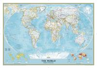
Wereldkaart 22005 Politiek, 111 x 77 cm | National Geographic

0
Politieke wereldkaart van National Geographic. De klassieke blauwe vorm, met helder kaartbeeld. De landen hebben met kleuren duidelijke grenzen en er staan opvallend veel topografische details op. Ondanks de schaal een behoorlijk aantal plaatsnamen. Mooi vormgegeven met een klassieke rand er om heen. This world map features the Winkel Tripel proje...

Verkopers met dit product

Verkoper
Bezorging
Prijs
DeZwerver.nl logo
DeZwerver.nl
5,95
36,95

Anderen bekeken ook

Wereldkaart 22005 Politiek, 111 x 77 cm | National Geographic
Politieke wereldkaart van National Geographic. De klassieke blauwe vorm, met helder kaartbeeld. De landen hebben met kleuren duidelijke grenzen en er staan opvallend veel topografische details op. Ondanks de schaal een behoorlijk aantal plaatsnamen. Mooi vormgegeven met een klassieke rand er om heen. This world map features the Winkel Tripel projection to reduce distortion of land masses as they near the poles. Features include subtle border coloring on land, and prevailing winds and ocean currents at sea. Separate insets show the North and South Polar Regions, world vegetation and land use, and world population density. This version is laminated—featuring a "write and wipe" surface and durable plastic covering.  
36,95
Wereldkaart 22005 Politiek, 110 x 77 cm | National Geographic
Politieke wereldkaart van National Geographic. De klassieke blauwe vorm, met helder kaartbeeld. De landen hebben met kleuren duidelijke grenzen en er staan opvallend veel topografische details op. Ondanks de schaal een behoorlijk aantal plaatsnamen. Mooi vormgegeven met een klassieke rand er om heen. This world map features the Winkel Tripel projection to reduce distortion of land masses as they near the poles. Features include subtle border coloring on land, and prevailing winds and ocean currents at sea. Separate insets show the North and South Polar Regions, world vegetation and land use, and world population density.  
27,95
Wereldkaart 22005 Politiek, 110 x 77 cm | National Geographic
Politieke wereldkaart van National Geographic. De klassieke blauwe vorm, met helder kaartbeeld. De landen hebben met kleuren duidelijke grenzen en er staan opvallend veel topografische details op. Ondanks de schaal een behoorlijk aantal plaatsnamen. Mooi vormgegeven met een klassieke rand er om heen.   Uitvoering met blauwe metalen ophangstrips   This world map features the Winkel Tripel projection to reduce distortion of land masses as they near the poles. Features include subtle border coloring on land, and prevailing winds and ocean currents at sea. Separate insets show the North and South Polar Regions, world vegetation and land use, and world population density.
47,95
Wereldkaart 82PH Politiek, 110 x 77 cm | National Geographic
Politieke wereldkaart van National Geographic. De klassieke blauwe vorm, met helder kaartbeeld. De landen hebben met kleuren duidelijke grenzen en er staan opvallend veel topografische details op. Ondanks de schaal een behoorlijk aantal plaatsnamen. Mooi vormgegeven met een klassieke rand er om heen.   De geplastificeerde kaart wordt geleverd met blank houten stokken aan de boven- en onderzijde, zoals we die uit het klaslokaal nog wel kennen. Aan de bovenstuk zit een linnen koord waarmee de kaart eenvoudig aan een flinke spijker of schroef kan worden opgehangen.   This world map features the Winkel Tripel projection to reduce distortion of land masses as they near the poles. Features include subtle border coloring on land, and prevailing winds and ocean currents at sea. Separate insets show the North and South Polar Regions, world vegetation and land use, and world population density.  
135,-
Wereldkaart Politiek, 92 x 61 cm | National Geographic
Politieke wereldkaart van National Geographic. De klassieke blauwe vorm, met helder kaartbeeld. De landen hebben met kleuren duidelijke grenzen en er staan opvallend veel topografische details op. Ondanks de schaal een behoorlijk aantal plaatsnamen. Mooi vormgegeven met een klassieke rand er om heen.   This world map features the Winkel Tripel projection to reduce distortion of land masses as they near the poles. Features include subtle border coloring on land, and prevailing winds and ocean currents at sea. Separate insets show the North and South Polar Regions, world vegetation and land use, and world population density.
32,95
Wereldkaart 22008 Politiek, 176 x 122 cm | National Geographic
Politieke wereldkaart van National Geographic. De klassieke blauwe vorm, met helder kaartbeeld. De landen hebben met kleuren duidelijke grenzen en er staan opvallend veel topografische details op. Ondanks de schaal een behoorlijk aantal plaatsnamen. Mooi vormgegeven met een klassieke rand er om heen.   This world map features the Winkel Tripel projection to reduce distortion of land masses as they near the poles. Features include subtle border coloring on land, and prevailing winds and ocean currents at sea. Separate insets show the North and South Polar Regions, world vegetation and land use, and world population density.   Groot formaat 176 x 122 / papieren versie
52,95
Wereldkaart 22008 Politiek, 176 x 122 cm | National Geographic
Politieke wereldkaart van National Geographic. De klassieke blauwe vorm, met helder kaartbeeld. De landen hebben met kleuren duidelijke grenzen en er staan opvallend veel topografische details op. Ondanks de schaal een behoorlijk aantal plaatsnamen. Mooi vormgegeven met een klassieke rand er om heen.   Groot formaat 176 x 122 cm / geplastificeerde versie.   This world map features the Winkel Tripel projection to reduce distortion of land masses as they near the poles. Features include subtle border coloring on land, and prevailing winds and ocean currents at sea. Separate insets show the North and South Polar Regions, world vegetation and land use, and world population density.
74,95
Wereldkaart 20379 politiek, 92 x 61 cm | National Geographic
Politieke wereldkaart van National Geographic. De klassieke blauwe vorm, met helder kaartbeeld. De landen hebben met kleuren duidelijke grenzen en er staan opvallend veel topografische details op. Ondanks de schaal een behoorlijk aantal plaatsnamen. Mooi vormgegeven met een klassieke rand er om heen.   This world map features the Winkel Tripel projection to reduce distortion of land masses as they near the poles. Features include subtle border coloring on land, and prevailing winds and ocean currents at sea. Separate insets show the North and South Polar Regions, world vegetation and land use, and world population density.
24,95

Klanten-reviews van Wereldkaart 22005 Politiek, 111 x 77 cm | National Geographic

Er zijn nog geen beoordelingen voor dit productBen jij de eerste die een review plaatst?

Meer over Wereldkaart 22005 Politiek, 111 x 77 cm | National Geographic

Productomschrijving

Politieke wereldkaart van National Geographic. De klassieke blauwe vorm, met helder kaartbeeld. De landen hebben met kleuren duidelijke grenzen en er staan opvallend veel topografische details op. Ondanks de schaal een behoorlijk aantal plaatsnamen. Mooi vormgegeven met een klassieke rand er om heen.

This world map features the Winkel Tripel projection to reduce distortion of land masses as they near the poles. Features include subtle border coloring on land, and prevailing winds and ocean currents at sea. Separate insets show the North and South Polar Regions, world vegetation and land use, and world population density. This version is laminated—featuring a "write and wipe" surface and durable plastic covering.


Productinformatie

    Verken gerelateerde categorieën

    Webshop.nl maakt gebruik van cookies. Ga je verder op onze website, ga dan akkoord met het plaatsen van cookies en de verwerking van deze data door ons en vermelde partners.