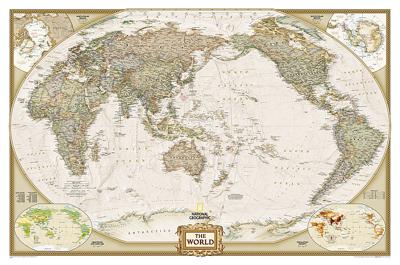

Wereldkaart 20327 Politiek & antiek, pacific centered, 117 x 78 cm | National Geographic

0
National Geographic's World map is the standard by which all other reference maps are measured. The World map is meticulously researched and adheres to National Geographic's convention of making independent, apolitical decisions based on extensive research using multiple authoritative source.   The Executive style World map uses an antique-style c...

Alle aanbiedingen van dit product

Verkoper
Bezorging
Prijs
DeZwerver.nl logo
DeZwerver.nl
6,95
26,95

Anderen bekeken ook

Memoir '44 The Battles of Khalkhin-Gol
Memoir '44 The Battles of Khalkhin-Gol The Battles of Khalkhin-Gol , the first installment in Days of Wonder's second series of Memoir '44 Battle Maps, offers a campaign of six standard scenarios that can be enhanced with the two pre-printed Breakthrough battles provided in this expansion.In more detail, The Battles of Khalkhin-Gol is a series of battles fought along the Halha River (Khalkhin-Gol) on the Soviet-Japanese border at the very beginning of World War II. The Japanese Sixth Army was facing the Soviet 57th Special Corps, including Mongolian cavalry. At first, the battles were only short skirmishes, but it soon escalated into open war. The whole campaign lasted five months and ended with a Soviet victory. The six standard scenarios of this expansion can be played separately or as a campaign, with each scenario outcome impacting the following one. The pre-printed Breakthrough scenarios - Bain Tsagan Heights and Tightening the Noose - can be played in the campaign as well as one …
27,95
Memoir '44 Breakthrough
Memoir '44 Breakthrough Go deep behind enemy lines at Sword Beach as you airdrop in to capture the bridges of the Orne... Join Guderian's famed Panzers as they battle the armored columns of the British Expeditionary Forces... Sign on for Operation Crusader to take on Rommel in the deserts of North Africa and liberate the garrison in Tobruk...The Memoir '44 Breakthrough Expansion will take you deep into the battles of World War II with two, double-sided, 9-panel board maps covering all four Memoir '44 map environments - countryside, beach, winter and deserts These oversize boards stretch the limit of current printing technology and are 13 x 17 hexes deep, opening up the Breakthrough format to new, more expansive scenarios.The  Memoir '44 Breakthrough Expansion includes 15, never-in-print-before scenarios, created by Jacques "jdRommel" David, and Memoir '44 author, Richard Borg.These scenarios cover the Western and Eastern Fronts, as well as the Mediterranean and Pacific Theaters and inc…
48,95

Klanten-reviews van Wereldkaart 20327 Politiek & antiek, pacific centered, 117 x 78 cm | National Geographic

Er zijn nog geen beoordelingen voor dit productBen jij de eerste die een review plaatst?

Meer over Wereldkaart 20327 Politiek & antiek, pacific centered, 117 x 78 cm | National Geographic

Productomschrijving

National Geographic's World map is the standard by which all other reference maps are measured. The World map is meticulously researched and adheres to National Geographic's convention of making independent, apolitical decisions based on extensive research using multiple authoritative source.   The Executive style World map uses an antique-style color palette and stunning shaded relief that provide a richness perfect for any decor. The Pacific Centered World map employs a unique view to accentuate the Pacific Rim, and focuses on Oceania and Asia and while showing the entire breadth of the Pacific Ocean. Drawn in a special Winkel Tripel projection, distortions are minimized and unlike many other World maps, Greenland is show the same size as Argentina and not as the size of all of South America.   Thousands of place names are carefully and artistically placed on the map to maintain legibility even in the heavily populated ares of Europe, Asia and the Middle East. Details include clearly defined international boundaries, cities, physical features, rivers, and ocean floor features. Corner inset maps feature vegetation and land use, and population density as well as the north and south polar regions.   The map is packaged in a two inch diamater clear plastic tube. The tube has a decorative label showing a thumbnail of the map with dimensions and other pertinent information.

Productinformatie

    Verken gerelateerde categorieën

    Webshop.nl maakt gebruik van cookies. Ga je verder op onze website, ga dan akkoord met het plaatsen van cookies en de verwerking van deze data door ons en vermelde partners.