webshop.nl
Categorieën
  Sluiten

Meer ITMB

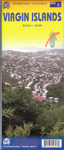
Wegenkaart - landkaart Virgin - Maagden Eilanden | ITMB

Een degelijke kaart met aanduidingen van o.a. nationale parken, vliegveld, benzinepomp, dirt-roads en kleine plattegrond van hoofdstad. Als overzichtskaart goed te gebruiken. Virgin Islands Travel Reference Map is a brand new artwork and has been digitally prepared from GIS downloads, so is extremely precise in its portrayal of physical features. T...
13,95

Webshops met dit product

Webshop
Bezorging
Prijs

Anderen bekeken ook

Wegenkaart - landkaart Virgin Islands - Maagden eilanden | Borch
The soft-laminated map of the Virgin Islands includes: US Virgin Islands 1:80 000, St. Croix 1:80 000, Charlotte Amalie 1:15 000, Charlotte Amalie Historic District 1:7 500, Cruz Bay 1:15 000, Christiansted, Frederiksted 1:15 000, British Virgin Islands 1:80 000, Anegada 1:80 000, Road Town, The Valley (Spanish Town) 1:15 000, Lesser Antilles 1:7 000 000, Virgin Islands administrative / time zones; interesting statistics British / US Virgin Islands: conversion chart for temperatures, weights and measures; climate chart with temperatures, sunshine hours, precipitation and humidity; hotels, museums, markets and much more.   Virgin Islands is the name of two groups of small islands east of Puerto Rico which form the Virgin Islands archipelago. They lie between the Caribbean Sea and the Atlantic Ocean. One of the groups which consists of St. Croix, St. John and St. Thomas islands, together with many nearby islets, is called the U.S. Virgin Islands. The other group including Anegada, Jost v…
11,50
Wegenkaart - landkaart US Virgin Islands & Puerto Rico | ITMB
Puerto Rico: schaal 1:190.000 US Virgin Islands: schaal 1:50.000   We are really pleased with this new edition of Puerto Rico. We spent part of August, 2020, touring the island and geo-referencing its many highways. The island is bigger and more densely road-networked than we thought, so we'll have to complete the job on our next visit, but the roads are now much more precisely shown accurately than was possible before satellite imagery. The map looks great on an Ipad screen as well. The map also shows updated inset maps of San Juan, Ponce, Mayaguez, Aguadilla, and Arecibo. Puerto Rico is part of the United States, so has all the benefits, but is internally self-governing. With this edition we are including a map of the other US colonial territory, the US Virgin Islands. The Danish West Indies was purchased from Denmark in 1917 and is an integral part of the USA, with all its benefits, but is, like Puerto Rico, neither fish nor fowl. It is internally self-governing and a great retireme…
13,95
Wegenkaart - landkaart Montana & Idaho | ITMB
Een degelijke kaart met aanduidingen van o.a. nationale parken, vliegveld, benzinepompen. ITMB is pleased to release two more state maps, this time of Montana on one side, and adjacent Idaho on the other side. Montana prides itself on being the ‘blue sky’ state. Due to its high elevation, the sky does appear to be a darker shade of blue than is common in areas closer to the ocean. The state is lightly populated, so much of its attractiveness rests with natural features, such as Glacier National Park on the Canadian border, and Yellowstone National Park on the Wyoming border. The state is also perfect camping country, and our map includes dozens of authorized campsites. It also includes the national heritage site of Little Big Horn, where Lt. Colonel Custer and the US 7th Cavalry were massacred after foolishly attacking a vastly larger encampment of Sioux and Cheyenne first nations people under the leadership of Sitting Bull. The second side of the map portrays the State of Idaho, an eq…
13,95
Wegenkaart - landkaart US Virgin Islands & Puerto Rico | ITMB
Puerto Rico: schaal 1:190.000 US Virgin Islands: schaal 1:50.000   We are really pleased with this new edition of Puerto Rico. We spent part of August, 2020, touring the island and geo-referencing its many highways. The island is bigger and more densely road-networked than we thought, so we'll have to complete the job on our next visit, but the roads are now much more precisely shown accurately than was possible before satellite imagery. The map looks great on an Ipad screen as well. The map also shows updated inset maps of San Juan, Ponce, Mayaguez, Aguadilla, and Arecibo. Puerto Rico is part of the United States, so has all the benefits, but is internally self-governing. With this edition we are including a map of the other US colonial territory, the US Virgin Islands. The Danish West Indies was purchased from Denmark in 1917 and is an integral part of the USA, with all its benefits, but is, like Puerto Rico, neither fish nor fowl. It is internally self-governing and a great retireme…
13,95
Wegenkaart - landkaart Maui, Kauai, & Molokai | ITMB
At long last, we have finally found time to complete our detailed mapping of the American state of Hawaii. The island of Maui may not be at well-known as Oahu, which is extremely popular with Japanese honeymooners, but it is as attractive touristically. Our coverage covers most of Side 1 and includes a detailed inset map of Wailuku, the principal urban area, as well as insets of Lahaina on the west coast and Wailea resort area. This side also includes a map of the island of Lanai, with its main urban area of Lanai City as an inset. Side 2 concentrates on the islands of Molokai, Kauai, and the lightly populated island of Ni’ihau, and includes detailed inset maps of Lihue, Kaunakakai, and Po’ipu, all of which are major resort destinations. The islands are loaded with beaches and places to stay, but also with attractions, which are shown on the map. This is a beautiful map, one of the best we have ever produced, and is a fitting companion to our maps of Big Island, and Oahu/Honolulu, as w…
13,95
Wegenkaart - landkaart Egypt & Cairo | ITMB
Following the so-called Arab spring of a few years ago, northern Africa experienced much turbulence. Egypt experienced the overthrow of the government, the installation of a radical religious-oriented replacement, and the installation of military governance. Tourism plummeted. Most map publishers discontinued their maps of the country. Five years later, Egypt has stabilized and tourism is growing. We feel that the time is right to re-introduce our ITMB map of Egypt. This version focuses on the portions of the country that have been re-opened for tourism, which means from the Mediterranean coastline south to the Aswan Dam. The portion further south remains closed for the moment, as is the border crossing with Sudan. We have also been forced to leave off the Great Sand Sea and the Western Desert portions for the same reason of unrest, as the border areas with Libya remain very unstable. However, we have provided a large inset map of Egypt, covering everything, in the area of desert. We h…
13,95
Wegenkaart - landkaart Brazilië | ITMB
Een degelijke kaart met aanduidingen van o.a. nationale parken, vliegveld, benzinepomp, dirt-roads en kleine plattegrond van hoofdstad. Als overzichtskaart goed te gebruiken. Brazil, or more properly, Brasil, is a difficult country to map as a country, in that most of the developed areas are in the relatively small extreme south of the country. The vast region of the Amazon Basin is lightly populated and is not easy to access. Our solution has been to portray the south portion on one side at a detailed scale, to enable such locations as Rio and Sao Paulo a better scale to help travellers, while mapping the north at a respectable but more limited scale on the That said, one still needs both sides of the map, as Brasilia, the capital, falls on the north side other side of the sheet. I should also note that roads north of Brasilia tend to be less well-paved than those in the south. The  shape of the country also presents mapping difficulties, in that little room is available for inset map…
13,95

Klanten-reviews van Wegenkaart - landkaart Virgin - Maagden Eilanden | ITMB

Er zijn nog geen beoordelingen voor dit productBen jij de eerste die een review plaatst?

Meer over Wegenkaart - landkaart Virgin - Maagden Eilanden | ITMB

Productomschrijving

Een degelijke kaart met aanduidingen van o.a. nationale parken, vliegveld, benzinepomp, dirt-roads en kleine plattegrond van hoofdstad. Als overzichtskaart goed te gebruiken. Virgin Islands Travel Reference Map is a brand new artwork and has been digitally prepared from GIS downloads, so is extremely precise in its portrayal of physical features. This version is printed on double-sided ITM plastic paper for both durability and waterproofing, and covers both the British and the American land masses that comprise the Virgins. Named after Queen Elizabeth the First, the network of islands has a colourful history which we have enhanced in a series of topical capsule comments. The more populated island of St. Croix includes an elaborate myriad of roads and inset maps of Christiansted and Frederiksted. The St. Thomas island portion includes detailed insets of Charlotte Amalie and Cruz Bay on St. Johns. The other side of the sheet covers the BVI region; less populated and oh so very British. I remember staying in Road Town for several days many years ago. This map includes an inset of the town showing all the major buildings and nothing has changed since I was there fifteen years ago. The map also includes an inset of The Valley, the only town on Virgin Gorda and, I’m sure, the only map ever published of that small settlement. Legend Includes: Roads by classification, Airports, Harbors, Gas Stations, Shipwrecks, Hotels, Lodges, Castles, Museums, Monuments, Churches, Historical Sites, Ruins, Viewpoints, Point of Interests, Police Stations, Schools, Hospitals, Shopping Centres, Light Houses, Beaches, Wind Mills, Caves, Parks, Zoos, and more.

Productspecificaties

Artikelnummer(s)
Brand
ITMB
Webshop.nl maakt gebruik van cookies. Ga je verder op onze website, ga dan akkoord met het plaatsen van cookies en de verwerking van deze data door ons en vermelde partners.