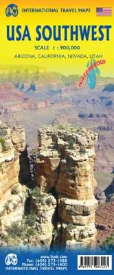
Wegenkaart - landkaart USA Southwest - zuidwest | ITMB

0
Een degelijke kaart met aanduidingen van o.a. nationale parken, vliegveld, benzinepomp, dirt-roads. Als overzichtskaart goed te gebruiken   We're introducing a map of the US Southwest States, notably most of California and Nevada, Arizona, most of Utah, and the western third of New Mexico and Colorado. Our regional series is at 1:1M scale. This re...

Verkopers met dit product

Verkoper
Bezorging
Prijs
DeZwerver.nl logo
DeZwerver.nl
2,95
13,95

Anderen bekeken ook

Wegenkaart - landkaart USA Southwest - zuidwest | ITMB
Een degelijke kaart met aanduidingen van o.a. nationale parken, vliegveld, benzinepomp, dirt-roads. Als overzichtskaart goed te gebruiken   We're introducing a map of the US Southwest States, notably most of California and Nevada, Arizona, most of Utah, and the western third of New Mexico and Colorado. Our regional series is at 1:1M scale. This results in instances where the name of the map may differ from the common perception. In US parlance, the 'Southwest' is often thought to be Arizona and New Mexico, whereas in reality it is southern California, Nevada, and Arizona. If one includes New Mexico, the square sheet of paper has to go so far north that one ends up including Denver. This is our compromise and we'll figure out how to deal with Texas, New Mexico, Louisiana, and Oklahoma a bit further down the line. This double-sided map covers from Reno and Sacramento in the north to Tijuana and Deming NM in the south, and from the Pacific coastline in the west to Gallop NM and Grand Jun…
13,95
Wegenkaart - landkaart 6 Southwest, zuidwest USA - Utah, Colorado, Arizona & New Mexico | Hallwag
Uitstekende wegenkaart waarbij de Europese kleurstelling de kaart zeer prettig leesbaar maken i.v.m. met Amerikaanse kaartenmakers. Deze kaart is eenzijdig bedrukt. Op de kaart is informatie te vinden waar allerlei voorzieningen te vinden zijn (d.m.v. symbolen), zoals campings, picknickplaatsen, informatiecentra, luchthavens enz. Bij de kaart zit een apart boekje met een aantal kleine stadsplattegronden, informatie over Nationale Parken en overige informatie voor toeristen.   Met Southern Rockies & Canyon Country (Utah, Colorado, Arizona & New Mexico)   These new, region by region "USA Road Guides", on a scale of 1 : 1 mio, provide up-to-date, detailed road maps with lots of tourist information. Transit and city maps, as well as detailed maps of national parks, are included in the map layout. The map package also includes a mileage chart with travelling times between major cities, and a brochure with an index of places, travel information from A to Z, top attractions and travel tips. …
14,50
Wegenkaart - landkaart 2 Southwest-USA - Zuidwest USA | Borch
Mooie geplasticieerde kaart van het Zuidwesten van de USA. Deze kaart biedt een goed overzicht van het land met detailkaarten.   Our soft-laminated folded map of the American Southwest shows: American Southwest 1:3 000 000, Phoenix 1:20 000, San Francisco Bay Area 1:400 000, San Francisco 1:15 000, Greater Los Angeles 1:250 000, San Diego 1:125 000, San Diego Downtown 1:25 000, Las Vegas - The Strip 1:22 000, Grand Canyon National Park 1:250 000, USA administrative & time zones. Borch Maps show hotels, museums, monuments, markets, public transport, top sights and points of interest, useful statistics, conversion charts for temperatures, weights and measurements, climate charts showing temperatures, sunshine hours, precipitation and humidity, overview maps, time zones, and much more...   From the panoramas of San Francisco and the buzz of megametropolis Los Angeles to the charm of San Diego on the Mexican border - the Californian coast boasts sun, beautiful beaches, stunning scenery an…
11,50
Reisgids Southwest USA - Zuidwest USA | Lonely Planet
De perfecte reisgids voor zowel de georganiseerde als de zelfstandige reiziger. Naast een algemene inleiding van het land / streek vol met praktische informatie over hoe je er het beste kunt reizen: slapen, eten, vervoer, excursies ... alles kun je er in vinden. Engelstalig. Lonely Planet's local travel experts reveal all you need to know to plan the trip of a lifetime in this latest edition of our guide to Southwest USA.   Discover Southwest USA's most popular experiences and best kept secrets from hiking to the blue-green waters at Havasu Falls; to passing the world's most iconic cacti at Saguaro National Park; and riding a mining train into an old copper mine in Bisbee, a lovably eccentric town in southern Arizona.   Build a trip to remember with Lonely Planet's Southwest USA travel guide:   Our classic guidebook format contains the most comprehensive level of information for planning multi-week trips All-new structure and design that's easy to use so you can navigate South…
24,95
Wegenkaart - landkaart Wales & southwest England | ITMB
Een degelijke kaart met aanduidingen van o.a. nationale parken, vliegveld, benzinepompen. Finally, we have been able to create our own map of the lovely country of Wales. I use the word ‘country’ in its truest sense, as Wales was invaded and taken over by the English centuries ago. Regardless, the Welsh language and Welsh culture continue to flourish, although English is commonly spoken. We have visited Wales on several occasions and find that the attractions are so numerous that we could never see them all. There are too many castles to count, but some of the best preserved in the British Isles are in Wales, notable Caernarfon, but nearby Harlech is a World Heritage Site. St, David’s must be one of the smallest and loveliest cathedrals in the world, and Tintern Abbey ruins among the most poignant anywhere. We took Johnny to Abergavenny for lunch in March, not that it made any difference; he just pined for a McDonalds. This map is double-sided, with Wales on one side and the West Coun…
13,95
Wegenkaart - landkaart Washington State - British Columbia southwest | ITMB
Een degelijke kaart met aanduidingen van o.a. nationale parken, vliegveld, benzinepomp, dirt-roads en campsites. Als overzichtskaart goed te gebruiken. This map hopes to accomplish two goals; first, it is a detailed road and points of interest map for Washington State and adds to our growing range of State covered in detail, and second, it combines that portion of Canada's BC accessible to Americans heading north. The map has two covers so can be marketed either as a USA map title or a Canadian title. The front side covers all of Washington State, with a bit of Oregon and Idaho, and has a decent-sized inset map of downtown Seattle. The reverse side covers much-larger British Columbia - at least a portion of it, including all of Vancouver Island, all the roads from Vancouver eastwards to the Rockies and north to Kamloops, and hundreds of wilderness campsites in the interior. This side also includes insets of Victoria and downtown Vancouver. This map fills a gap in the travel map market…
13,95
Wegenkaart - landkaart USA Rocky Mountains | ITMB
This is the latest American regional map that ITMB has published. This one covers Montana, Wyoming, Colorado, and parts of Idaho, New Mexico, and Arizona. It is, of course, the southern extension of the Canadian Rockies map through Blue Sky Montana and Mile High Denver. This is a double-sided map concentrating on roads and road quality, parks, touristic attractions, and urban areas. We feel that the state-by-state approach to mapping the USA just does not work well. With todays infrastructure and vehicular capability, one can pass through three or four states in a normal day drive.  Legend Includes: Roads by classification, US Divided Highway, Mountain peak, State park, National park, Ferry Route, Historic Route 66, Hot Spring, Museum, Skiing, Beach, Cave and much more.
13,95
Wegenkaart - landkaart 3121 United States Southwest | National Geographic
Mooie kaart van de bekende kaartenmaker National Geographic. Veel details door kleurgebruik. De wegen zijn met kleuren verdeeld in drukke en minder drukke, de wegnummers zijn goed terug te vinden. De kaart onderscheidt zich van andere series door de hoeveelheid topografische details als counties, plaatsnamen en waterwegen en het bevat een register waarin het eenvoudig zoeken is. Daarnaast is de kaart gedrukt op scheur- en watervast papier. The United States Southwest Adventure Map will guide you through one of the most iconic and awe-inspiring regions on Earth. The states of Arizona and New Mexico contain Grand Canyon, Petrified Forest, and Saguaro National Parks, Monument Valley, Sonoran Desert, and dozens of celebrated National Monuments, Forests, and Wilderness Areas. The map includes the cities of Phoenix, Tucson, Sedona, Flagstaff, Santa Fe, and Albuquerque as well as the Navajo, Apache, Hopi, and many other Indian Reservations. It covers the entire Four Corners Region including …
17,50
Wegenkaart - landkaart 503 Wales, The Midlands, Southwest - zuidwest | Michelin
Zoals je van Michelin mag verwachten zijn het onmisbare overzichtskaarten van een uitstekende kwaliteit: een duidelijk en goed leesbaar kaartbeeld.  Vrijwel alle berijdbare wegen staan er op ingetekend, in kleur verschillend voor grote en kleine wegen. Andere weginformatie omvat bijvoorbeeld kilometer-afstanden, tolwegen, helling-aanduiding, winterafsluitingen, tankstations maar ook de bekende groene routes: de mooiste wegen om te rijden.   Daarnaast geeft de kaart toeristische informatie met symbolen weer: bezienswaardigheden als kastelen, kloosters, musea, maar ook campings (niet allemaal overigens). De kaart is voorzien van een 4-talige legenda.   Toch hebben de makers door een beperkt gebruik van symbolen geen drukke kaart gemaakt. De kracht zit hem dan ook in de combinatie van meer dan voldoende informatie en goede leesbaarheid.    Angleterre, Liverpool, Manchester, Midlands (Angleterre), Pays de Galles
11,95

Klanten-reviews van Wegenkaart - landkaart USA Southwest - zuidwest | ITMB

Er zijn nog geen beoordelingen voor dit productBen jij de eerste die een review plaatst?

Meer over Wegenkaart - landkaart USA Southwest - zuidwest | ITMB

Productomschrijving

Een degelijke kaart met aanduidingen van o.a. nationale parken, vliegveld, benzinepomp, dirt-roads. Als overzichtskaart goed te gebruiken   We're introducing a map of the US Southwest States, notably most of California and Nevada, Arizona, most of Utah, and the western third of New Mexico and Colorado. Our regional series is at 1:1M scale. This results in instances where the name of the map may differ from the common perception. In US parlance, the 'Southwest' is often thought to be Arizona and New Mexico, whereas in reality it is southern California, Nevada, and Arizona. If one includes New Mexico, the square sheet of paper has to go so far north that one ends up including Denver. This is our compromise and we'll figure out how to deal with Texas, New Mexico, Louisiana, and Oklahoma a bit further down the line. This double-sided map covers from Reno and Sacramento in the north to Tijuana and Deming NM in the south, and from the Pacific coastline in the west to Gallop NM and Grand Junction CO in the east; printed on durable ITM plastic paper. As with all US regional maps in our growing coverage, this map includes towns, roads, physical features, major parks and natural monuments, touristic attractions, and border crossings.   Legend Includes: Roads by classification, Airports, Ferrie routes, States boudaries, border crossing, Time zones, Dams, Harbours, State parks with or without campsites, Campsites, Wayside or Roadside parks, Hospitals, Museums, Tourist information centers, Points of interest, Spanish mission, Waterfalls, World heritage sites, Viewpoints, Lighthouses, Springs, Hot springs, Beaches, Mines and quarries, Nature reserves, Indian areas, Ranger stations, Caves, Universities, Golf courses, Skiing, Snowparks and much more.

Productinformatie

    Verken gerelateerde categorieën

    Webshop.nl maakt gebruik van cookies. Ga je verder op onze website, ga dan akkoord met het plaatsen van cookies en de verwerking van deze data door ons en vermelde partners.