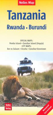
Wegenkaart - landkaart Tanzania, Rwanda en Burundi | Nelles Verlag

0
Goede kaart van Tanzania, Rwanda en Burundi. Aan beide kanten bedrukt. Met veel toeristische aanduidingen als nationale parken en culturele bezienswaardigheden. Prima leesbare kaart. Pemba Island 1 : 500.000 Zanzibar Island (Unguja) 1 : 300.000 Arusha 1 : 18.000 Dar es Salaam 1 : 30.000 Zanzibar-Stonetown 1 : 11.100 Folded road and tourist map of ...

Verkopers met dit product

Verkoper
Bezorging
Prijs
DeZwerver.nl logo
DeZwerver.nl
2,95
11,95

Anderen bekeken ook

Wegenkaart - landkaart Tanzania, Rwanda en Burundi | Nelles Verlag
Goede kaart van Tanzania, Rwanda en Burundi. Aan beide kanten bedrukt. Met veel toeristische aanduidingen als nationale parken en culturele bezienswaardigheden. Prima leesbare kaart. Pemba Island 1 : 500.000 Zanzibar Island (Unguja) 1 : 300.000 Arusha 1 : 18.000 Dar es Salaam 1 : 30.000 Zanzibar-Stonetown 1 : 11.100 Folded road and tourist map of Tanzania at 1:1 500 000 scale. Places of interest, national parks, beaches, lodges & camps are all highlighted and shaded-relief colouring clearly depicts the topography.   The map includes insets showing Dar es Salaam at 1:30 000, Zanzibar-Stonetown at 1:11 100, Arusha at 1:18 000, Pemba Island at 1:500 000, and Zanzibar Island (Unguja) at 1:300 000. The legend is in three languages including English.    
11,95
Wegenkaart - landkaart 3206 Adventure Map Tanzania - Rwanda - Burundi | National Geographic
Wegenkaart van Tanzania, Rwanda en Burundi met vermelding van veel bezienswaardigheden, nationale parken en attrakties. Watervast en scheurvast. Juist door deze vermeldingen onderscheidt de kaart zich van andere wegenkaarten. National Geographic's Tanzania, Rwanda, and Burundi Adventure Map is designed to meet the unique needs of adventure travelers with its durability and accurate information. This folded map provides global travelers with the perfect combination of detail and perspective, highlighting hundreds of points of interest and the diverse and unique destinations within the country. The map includes the locations of cities and towns with a user-friendly index, plus a clearly marked road network complete with distances and designations for major highways, main roads, and tracks and trails for those seeking to explore more remote regions.   The front side of the Tanzania map details the southern region of the country, from Zambia to the south, to the bordering country of Burun…
17,50
Wegenkaart - landkaart Rwanda & Burundi | ITMB
Een degelijke landkaart van Rwanda & Burundi met aanduidingen van o.a. nationale parken, vliegveld, benzinepomp, dirt-roads en kleine plattegrond van hoofdstad. Als overzichtskaart goed te gebruiken. The two central African countries of Rwanda and Burundi are gradually returning to prosperity. They are both very interesting countries, scenically attractive, and relatively untouched by modernism. Both have suffered serious unrest in the past, but have moved on and are determined to have a bright and happy future. The people are marvelous; one can’t express in a brief paragraph the warmth and friendliness of the ordinary people of both countries. This is really a part of Africa everyone should visit. It’s a very special place, and I’m pleased to introduce the latest edition of an excellent map for two of my favourite places. As with past editions, this is actually two completely separate maps, with Rwanda on one side and Burundi on the other. There are two different covers, so the map c…
13,95
Wegenkaart - landkaart Kenia - Kenya | Nelles Verlag
Goede kaart van Kenya en de Serengeti. Aan beide kanten bedrukt. Met veel toeristische aanduidingen als nationale parken en culturele bezienswaardigheden. Prima leesbare kaart. Folded road and tourist map of Kenya and the Serengeti at 1:1 100 000 scale. Places of interest, national parks, beaches and camps/lodges are all highlighted and shaded-relief colouring clearly depicts the topography.   The map includes insets showing central Nairobi at 1:20 000, Mombasa at 1:33 000, Lamu Island at 1:550 000 and the Kenya coast at 1:550 000. The legend is in English, French and German.   For over 20 years Nelles maps have been renowned throughout the world for their quality, faithfulness to detail and up-to-dateness.    So that streets, ferry links, railway lines, etc are always up to date, Nelles are continuously upgrading their maps - with the help of their international team of correspondents. Roads are provided with an exact kilometerage. Sights are highlighted extra clearly so that you don…
11,95
Wegenkaart - landkaart Bali & Lombok | Nelles Verlag
Goede wegenkaart van Bali & Lombok. Aan beide kanten bedrukt. Met veel toeristische aanduidingen als nationale parken en culturele bezienswaardigheden. Prima leesbare kaart. One of six maps in a series covering Indonesia, this is a folded road and tourist map of the two Indonesian islands of Bali and Lombok at 1:180 000 scale. Parks, beaches, and places of interest are all highlighted and shaded-relief coloyring clearly depicts the topography.    The map includes insets showing Ubud and it's surroundings at 1:33 000, Denpasar at 1:20 000, Kuta at 1:20 000, Lovina Beach at 1:30 000, Sanur at 1:35 000, Nusa Dua at 1:50 000, the Gili Islands at 1:55 000, Mataram at 1:50 000 and an overview locator map. The legend is in English, French and German.   For over 20 years Nelles maps have been renowned throughout the world for their quality, faithfulness to detail and up-to-dateness.    So that streets, ferry links, railway lines, etc are always up to date, Nelles are continuously upgrading th…
10,95
Wegenkaart - landkaart 810 Tanzania - Zanzibar | Michelin
Zoals je van Michelin mag verwachten is deze kaart zeer overzichtelijk en heeft een duidelijk helder kaartbeeld. De kaart geeft uitgebreid toeristische informatie weer. Met register, afstanden en reistijden. Wegen worden naar verschillende klasse ingedeeld en - mooi van Michelin - de interessante mooie routes worden gemarkeerd met een groene streep.    Hindernissen voor automobilisten met caravans zijn gemarkeerd: steile hellingen, bergpassen of een anderzins moeilijke route. Bezienswaardigheden als een kasteel, religieus gebouw, ruine of grot is door een symbool goed te vinden. De perfecte overzichtskaart, eenzijdig gedrukt! Op één puntje na: er staan geen benzinepompen op ..... dat is dan jammer voor de vele reizigers met eigen auto.   Met een kleine plattegrond van Dar es Salaam centrum en van Stone Town op Zanzibar.    Arusha, Dar es Salaam, Dodoma, Karatu, Lindi, Masasi, Mbeya, Morogoro, Mwanza, Songea, Tabora, Tanga, Tanzanie, Zanzibar
12,95
Wegenkaart - landkaart Hawaiian Islands - Hawaii | Nelles Verlag
Overzichtskaart van alle eilanden. Folded road and tourist map for the Hawaiian Islands, U.S.A. at mostly 1:150 000 scale. The map covers the individual islands of Maui, Hawai i, Moloka i, Oahu, Kauai and Lanai. Places of interest, national parks, and beaches are all highlighted and shaded-relief colouring clearly depicts the topography.    The map includes insets showing Waikiki Beach in Honolulu at 1:14 000 and the Hawaii Volcanoes National Park at 1:125 000. The legend is in three languages, including English.   For over 20 years Nelles maps have been renowned throughout the world for their quality, faithfulness to detail and up-to-dateness.    So that streets, ferry links, railway lines, etc are always up to date, Nelles are continuously upgrading their maps - with the help of their international team of correspondents. Roads are provided with an exact kilometerage. Sights are highlighted extra clearly so that you don't miss any tourist attractions.   A good map must be hard-weari…
11,95
Wegenkaart - landkaart Lesser Antilles - Caraibisch gebied - Antillen | Nelles Verlag
Goede wegenkaart van van een groot aantal eilanden. Aan beide kanten bedrukt. Met veel toeristische aanduidingen als nationale parken en culturele bezienswaardigheden. Prima leesbare kaart en zeker als overzichtskaart goed te gebruiken. Folded road and tourist map of the Lesser Antilles Caribbean island chain at 1:2 500 000 scale. Places of interest, national parks, and beaches are all highlighted and shaded-relief colouring clearly depicts the topography.   The map includes insets showing Trinidad and Tobago at 1:500 000, the Virgin Islands at 1:250 000, Anegada at 1:250 000, St. Croix at 1:300 000, Anguilla and St. Martin at 1:300 000, St. Kitts and Nevis at 1:300 000, St. Barts at 1:300 000, Saba at 1:300 000, St. Eustatius at 1:300 000, Montserrat at 1:300 000, Aruba at 1:150 000, Curacao at 1:300 000, Bonaire at 1:300 000, Barbados at 1:300 000, The Grenadines at 1:300 000, Grenada at 1:300 000, St. Vincent and The Grenadines at 1:300 000, Canouan at 1:300 000, Barbuda at 1:30…
11,95
Reisgids Tanzania & Zanzibar | Rough Guides
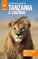
Zeer goede reisgids voor zowel de georganiseerde maar vooral voor de zelfstandige reiziger. Boordevol informatie over reizen, slapen, eten, maar ook musea en cultuur. Voor veel landen meestal completer en beter dan de Lonely Planet ! This Tanzania & Zanzibar guidebook is perfect for independent travellers planning a longer trip. It features all of the must-see sights and a wide range of off-the-beaten-track places. It also provides detailed practical information on preparing for a trip and what to do on the ground. And this Tanzania & Zanzibar travel guidebook is printed on paper from responsible sources, and verified to meet the FSC's strict environmental and social standards.   This Tanzania & Zanzibar guidebook covers: Dar es Salaam, The north coast, The south coast, Central Tanzania, The northern highlands, Arusha and around, The northern Safari Circuit, Lake Victoria and northwestern Tanzania, Lake Tanganyika and western Tanzania, Southern Tanzania, Zanzibar.   Inside this Tanzan…
25,95

Klanten-reviews van Wegenkaart - landkaart Tanzania, Rwanda en Burundi | Nelles Verlag

Er zijn nog geen beoordelingen voor dit productBen jij de eerste die een review plaatst?

Meer over Wegenkaart - landkaart Tanzania, Rwanda en Burundi | Nelles Verlag

Productomschrijving

Goede kaart van Tanzania, Rwanda en Burundi. Aan beide kanten bedrukt. Met veel toeristische aanduidingen als nationale parken en culturele bezienswaardigheden. Prima leesbare kaart.

Pemba Island 1 : 500.000
Zanzibar Island (Unguja) 1 : 300.000

Arusha 1 : 18.000
Dar es Salaam 1 : 30.000
Zanzibar-Stonetown 1 : 11.100

Folded road and tourist map of Tanzania at 1:1 500 000 scale. Places of interest, national parks, beaches, lodges & camps are all highlighted and shaded-relief colouring clearly depicts the topography.   The map includes insets showing Dar es Salaam at 1:30 000, Zanzibar-Stonetown at 1:11 100, Arusha at 1:18 000, Pemba Island at 1:500 000, and Zanzibar Island (Unguja) at 1:300 000. The legend is in three languages including English.    

Productinformatie

    Verken gerelateerde categorieën

    Webshop.nl maakt gebruik van cookies. Ga je verder op onze website, ga dan akkoord met het plaatsen van cookies en de verwerking van deze data door ons en vermelde partners.