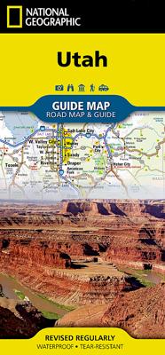
Wegenkaart - landkaart State Guide Map Utah | National Geographic

0
Makkelijk leesbare kaart aan 2 zijden bedrukt. De ene kant met informatie en beperkte stadsplattegronden, de andere met de daadwerkelijke kaart. De kaart is geplastificeerd en dus watervast! The front side is an easy-to-read road map with insets of: - Ogden - Logan The back includes: - Map and information for Salt Lake City - Information for Bryce...

Verkopers met dit product

Verkoper
Bezorging
Prijs
DeZwerver.nl logo
DeZwerver.nl
2,95
12,95

Anderen bekeken ook

Wegenkaart - landkaart State Guide Map Oregon | National Geographic
Makkelijk leesbare kaart aan 2 zijden bedrukt. De ene kan met informatie en beperkte stadsplattegronden, de andere met de daadwerkelijke kaart. De kaart is geplastificeerd en dus watervast! The front side features an inset of Eugene. The back includes maps and information for Portland and Salem, information for Crater Lake National Park, points of interest, scenic drives, and National Park Service sites in Oregon. National Geographic Guide Maps combine the most reliable road maps available with detailed travel guide information. One side features a detailed state highway map, enhanced with terrain detail and major city insets. The flip side presents tourist, historic, and recreation information, along with color photos, maps, and illustrations. All this folds into a convenient, durable, laminated map perfect for either vacation or business travel.
12,95
Wegenkaart - landkaart State Guide Map Washington | National Geographic
The front side features insets of Olympia, Yakima and Spokane. The back includes a map and information for Seattle, information for Olympic, North Cascades, and Mt. Rainier National Parks, points of interest, scenic drives, and Park Service sites in Washington. National Geographic Guide Maps combine the most reliable road maps available with detailed travel guide information. One side features a detailed state highway map, enhanced with terrain detail and major city insets. The flip side presents tourist, historic, and recreation information, along with color photos, maps, and illustrations. All this folds into a convenient, durable, laminated map perfect for either vacation or business travel.
12,95
Reisgids Utah | Insight Guides
Een rijk geillustreerde reisgids met diepgaande teksten: één van de beste reisgidsen die er bestaan. Eerste deel bestaat uit een beschrijving van de unieke aspecten van de regio, daarna een deel echte reisgids en als afsluiting een deel met praktische informatie. De uitstekende informatie wordt vergezeld van prachtige foto's en heldere kaarten. Niet alleen om mee te nemen, maar ook om vooraf en zelfs achteraf weer in de stemming te komen. This Insight Guide is a lavishly illustrated inspirational travel guide to Utah and a beautiful souvenir of your trip. Perfect for travellers looking for a deeper dive into the destination's history and culture, it's ideal to inspire and help you plan your travels. With its great selection of places to see and colourful magazine-style layout, this Utah guidebook is just the tool you need to accompany you before or during your trip. Whether it's deciding when to go, choosing what to see or creating a travel plan to cover key places like Canyonlands Na…
24,95
Wegenkaart - landkaart State Guide Map Colorado | National Geographic
Makkelijk leesbare kaart aan 2 zijden bedrukt. De ene kan met informatie en beperkte stadsplattegronden, de andere met de daadwerkelijke kaart. De kaart is geplastificeerd en dus watervast! The front side is an easy-to-read road map with insets of: - Fort Collins - Pueblo - Colorado Springs - Denver area - Mesa Verde National Park The back includes: - Map and information for Denver - Information for Mesa Verde National Park - Information for Rocky Mountain National Park - Points of interest - Scenic drive - Park Service sites in Colorado
12,95
Wegenkaart - landkaart State Guide Map Arizona | National Geographic
Makkelijk leesbare kaart aan 2 zijden bedrukt. De ene kan met informatie en beperkte stadsplattegronden, de andere met de daadwerkelijke kaart. De kaart is geplastificeerd en dus watervast! The front side is an easy-to-read road map with insets of: - Bullhead City / Laughlin - Yuma - Flagstaff - Tucson - Downtown Phoenix - Saguaro National Park - Petrified Forest National Park The back includes: - Map and information about Phoenix - Map and information for Grand Canyon National Park - Points of interest - Scenic drive - Park Service sites in Arizona  
12,95
Wegenkaart - landkaart State Guide Map New York | National Geographic
Makkelijk leesbare kaart aan 2 zijden bedrukt. De ene kan met informatie en beperkte stadsplattegronden, de andere met de daadwerkelijke kaart. De kaart is geplastificeerd en dus watervast! The front side is an easy-to-read road map with insets of: - Rochester - Syracuse - Utica - Binghamton - Albany / Schenectady / Troy The back includes: - Map and information for New York City - Map and information for Buffalo / Niagara Falls - Points of interest - Scenic drive - Park Service sites for New York State
12,95
Wegenkaart - landkaart State Guide Map Kentucky | National Geographic
Makkelijk leesbare kaart aan 2 zijden bedrukt. De ene kan met informatie en beperkte stadsplattegronden, de andere met de daadwerkelijke kaart. De kaart is geplastificeerd en dus watervast! The front side is an easy-to-read road map with insets of: - Covington, KY / Cincinnati, OH - Land Between the Lakes - Owensboro - Bowling Green - Frankfort The back includes: - Maps and information for Louisville and Lexington - Points of interest - Information for Mammoth Cave National Park - Scenic drive - Park Service sites for Kentucky
12,95
Wegenkaart - landkaart State Guide Map Massachusetts | National Geographic
Makkelijk leesbare kaart aan 2 zijden bedrukt. De ene kan met informatie en beperkte stadsplattegronden, de andere met de daadwerkelijke kaart. De kaart is geplastificeerd en dus watervast! The front side is an easy-to-read road map with insets of: - Lowell - Downtown Boston - Worcester - Springfield - Providence, RI - New Bedford / Fall River The back includes: - Map and information for Boston - Information for Cap Cod National Seashore - Points of interest - Scenic drive - Park Service sites in Massachusetts
12,95
Wegenkaart - landkaart State Guide Map Wisconsin | National Geographic
Makkelijk leesbare kaart aan 2 zijden bedrukt. De ene kan met informatie en beperkte stadsplattegronden, de andere met de daadwerkelijke kaart. De kaart is geplastificeerd en dus watervast! The front side is an easy-to-read road map with insets of: - Superior - Appleton - Oshkosh - Racine / Kenosha - Eau Claire - Green Bay - Milwaukee The back includes: - Maps and information for Milwaukee and Madison - Information for Apostle Islands National Lakeshore - St. Croix Scenic Riverway - Points of interest - Scenic drive - Park Service sites in Wisconsin
12,95
Wegenkaart - landkaart State Guide Map Virginia | National Geographic
Makkelijk leesbare kaart aan 2 zijden bedrukt. De ene kan met informatie en beperkte stadsplattegronden, de andere met de daadwerkelijke kaart. De kaart is geplastificeerd en dus watervast! The front side is an easy-to-read road map with insets of: - Washington DC area - Charlottesville - Lynchburg - Roanoke - Southwest Virginia - Colonial National Historical Park The back includes: - Maps and information for Richmond and Hampton Roads - Information for Shenandoah National Park - Points of interest - Scenic drive - Park Service sites in Virginia
12,95

Klanten-reviews van Wegenkaart - landkaart State Guide Map Utah | National Geographic

Er zijn nog geen beoordelingen voor dit productBen jij de eerste die een review plaatst?

Meer over Wegenkaart - landkaart State Guide Map Utah | National Geographic

Productomschrijving

Makkelijk leesbare kaart aan 2 zijden bedrukt. De ene kant met informatie en beperkte stadsplattegronden, de andere met de daadwerkelijke kaart. De kaart is geplastificeerd en dus watervast!

The front side is an easy-to-read road map with insets of: - Ogden - Logan The back includes: - Map and information for Salt Lake City - Information for Bryce Canyon, Arches, and Zion National Parks - Points of interest - Scenic drive - Park Service sites in Utah

Productinformatie

    Verken gerelateerde categorieën

    Webshop.nl maakt gebruik van cookies. Ga je verder op onze website, ga dan akkoord met het plaatsen van cookies en de verwerking van deze data door ons en vermelde partners.