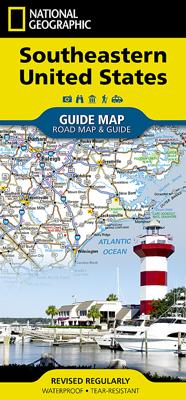
Wegenkaart - landkaart State Guide Map Southeastern United States - Zuidoost VS | National Geographic

0
Makkelijk leesbare kaart aan 2 zijden bedrukt. De ene kan met informatie en beperkte stadsplattegronden, de andere met de daadwerkelijke kaart. De kaart is geplastificeerd en dus watervast! The front side is an easy-to-read road map covering the states of southern Pennsylvania, southeastern Ohio, West Virginia, Virginia, Kentucky, parts of Illinoi...

Verkopers met dit product

Verkoper
Bezorging
Prijs
DeZwerver.nl logo
DeZwerver.nl
2,95
12,95

Anderen bekeken ook

Wegenkaart - landkaart State Guide Map Southeastern United States - Zuidoost VS | National Geographic
Makkelijk leesbare kaart aan 2 zijden bedrukt. De ene kan met informatie en beperkte stadsplattegronden, de andere met de daadwerkelijke kaart. De kaart is geplastificeerd en dus watervast! The front side is an easy-to-read road map covering the states of southern Pennsylvania, southeastern Ohio, West Virginia, Virginia, Kentucky, parts of Illinois and Indiana, Tennessee, North Carolina, South Carolina, Georgia, Florida, Alabama, Mississippi, and parts of Louisiana and Arkansas. There are several inset maps on the front. The back includes: - Information for Shenandoah, Great Smoky Mountains, and Everglades National Parks - Inset maps of New Orleans, Nashville, Orlando, and Miami.
12,95
Wegenkaart - landkaart 3126 Southeast United States | National Geographic
Mooie kaart van de bekende kaartenmaker National Geographic. Veel details door kleurgebruik. De wegen zijn met kleuren verdeeld in drukke en minder drukke, de wegnummers zijn goed terug te vinden. De kaart onderscheidt zich van andere series door de hoeveelheid topografische details als counties, plaatsnamen en waterwegen en het bevat een register waarin het eenvoudig zoeken is. Daarnaast is de kaart gedrukt op scheur- en watervast papier. The United States Southeast Adventure Map will guide you through the diverse landscapes of this remarkable region, from the white sand beaches of Florida, to the barrier islands of North Carolina, through the coastal plains and rolling piedmont regions, and into the stunning Blue Ridge Mountains of Virginia, West Virginia, North Carolina, Tennessee and Georgia. Great Smoky Mountains and Shenandoah National Parks straddle the ridge of the Appalachian Mountains and stand in dramatic contrast to the sawgrass marshlands of Everglades National Park and t…
17,50
Wegenkaart - landkaart 8 Southeast USA zuidoost | Hallwag
Uitstekende wegenkaart waarbij de Europese kleurstelling de kaart zeer prettig leesbaar maken i.v.m. met Amerikaanse kaartenmakers. Deze kaart is eenzijdig bedrukt. Op de kaart is informatie te vinden waar allerlei voorzieningen te vinden zijn (d.m.v. symbolen), zoals campings, picknickplaatsen, informatiecentra, luchthavens enz. Bij de kaart zit een apart boekje met een aantal kleine stadsplattegronden, informatie over Nationale Parken en overige informatie voor toeristen. Middle Atlantic & Appalachen, Indiana, South Illinois,  Ohio, Pennsylvania, New Jersey, Virginia, North & South Carolina These new, region by region "USA Road Guides", on a scale of 1 : 1 mio, provide up-to-date, detailed road maps with lots of tourist information. Transit and city maps, as well as detailed maps of national parks, are included in the map layout. The map package also includes a mileage chart with travelling times between major cities, and a brochure with an index of places, travel information from A…
14,50
Wegenkaart - landkaart State Guide Map Virginia | National Geographic
Makkelijk leesbare kaart aan 2 zijden bedrukt. De ene kan met informatie en beperkte stadsplattegronden, de andere met de daadwerkelijke kaart. De kaart is geplastificeerd en dus watervast! The front side is an easy-to-read road map with insets of: - Washington DC area - Charlottesville - Lynchburg - Roanoke - Southwest Virginia - Colonial National Historical Park The back includes: - Maps and information for Richmond and Hampton Roads - Information for Shenandoah National Park - Points of interest - Scenic drive - Park Service sites in Virginia
12,95
Wegenkaart - landkaart State Guide Map Southern California | National Geographic
Makkelijk leesbare kaart aan 2 zijden bedrukt. De ene kan met informatie en beperkte stadsplattegronden, de andere met de daadwerkelijke kaart. De kaart is geplastificeerd en dus watervast! The front side is an easy-to-read road map with insets of: Palm Springs Monterey Bay Area Fresno Santa Barbara Bakersfield Los Angeles area Oxnard / Ventura San Diego The back includes: Maps and information for Los Angeles and San Diego nformation for Sequoia and Kings Canyon National Parks Points of interest Scenic drive Park Service sites in Southern California
12,95
Wegenkaart - landkaart 6 Zuidoost USA - Southeast USA | Borch
Mooie geplasticieerde kaart van het Zuidoosten van de USA. Deze kaart biedt een goed overzicht van het land met detailkaarten. Our soft-laminated map of the southeast of the USA - USA 6 includes: The South & Florida 1:3 000 000, Central Florida 1:1 350 000, Atlanta & Region 1:1 000 000, Atlanta Downtown 1:15 000, Miami & Florida Keys 1:1 000 000, Miami Downtown 1:20 000, South Miami Beach 1:20 000, New Orleans & Region 1:1 000 000, New Orleans French Quarter 1:13 000, USA administrative & time zones, interesting statistics, conversion chart for temperatures, weights and measures, climate chart with temperatures, sunshine hours, precipitation and humidity and much more.   From Washington D.C. along the Atlantic coast to Florida and west to Louisiana and Arkansas, this is original plantation country, which has long since "gone with the wind". Yet traces of the charming Old South can still be found in the historic cities of Alexandria, Williamsburg, Charleston, and Savannah, and along th…
11,50
Wegenkaart - landkaart State Guide Map Oregon | National Geographic
Makkelijk leesbare kaart aan 2 zijden bedrukt. De ene kan met informatie en beperkte stadsplattegronden, de andere met de daadwerkelijke kaart. De kaart is geplastificeerd en dus watervast! The front side features an inset of Eugene. The back includes maps and information for Portland and Salem, information for Crater Lake National Park, points of interest, scenic drives, and National Park Service sites in Oregon. National Geographic Guide Maps combine the most reliable road maps available with detailed travel guide information. One side features a detailed state highway map, enhanced with terrain detail and major city insets. The flip side presents tourist, historic, and recreation information, along with color photos, maps, and illustrations. All this folds into a convenient, durable, laminated map perfect for either vacation or business travel.
12,95
Wegenkaart - landkaart 584 Southeastern USA - Zuidoost USA | Michelin
Wegenkaart van zuidoostelijk Amerika (zuid vanaf Torreon en Saltillo, west El Paso en Albuquerque, noord in een lijn van Denver naar Washington DC. Primary & secondary road networks are clearly marked out with indications of the number of lanes, intermediate distances and various possible road obstacles or things you should know including steep hills, height limits, toll barriers, prohibited roads and roads subject to restrictions.   The map also includes small insets with street plans of the regions major towns, showing road names, one way streets and various places of interest (tourist sights, hospitals, parking, railway stations, etc.). Scenic routes on the map are marked out in green and an extensive index of place names is included.   The map also features:   Administrative boundaries Railways, Airports and Ferry Services Important sights such as castles, ruins, and churches Driving Times and Distance Charts Road Safety Information A legend in multiple languages, including Englis…
12,95
Wegenkaart - landkaart State Guide Map North Carolina | National Geographic
Makkelijk leesbare kaart aan 2 zijden bedrukt. De ene kan met informatie en beperkte stadsplattegronden, de andere met de daadwerkelijke kaart. De kaart is geplastificeerd en dus watervast! The front side is an easy-to-read road map with insets of: - Asheville - Charlotte - Winston / Salem / Greensboro - Fayetteville - Wilmington - Western North Carolina The back includes: - Map and information for Raleigh / Durham - Information on Great Smoky Mountain National Park - Points of interest - Scenic drive - Park Service sites in North Carolina
12,95
Wegenkaart - landkaart 3121 United States Southwest | National Geographic
Mooie kaart van de bekende kaartenmaker National Geographic. Veel details door kleurgebruik. De wegen zijn met kleuren verdeeld in drukke en minder drukke, de wegnummers zijn goed terug te vinden. De kaart onderscheidt zich van andere series door de hoeveelheid topografische details als counties, plaatsnamen en waterwegen en het bevat een register waarin het eenvoudig zoeken is. Daarnaast is de kaart gedrukt op scheur- en watervast papier. The United States Southwest Adventure Map will guide you through one of the most iconic and awe-inspiring regions on Earth. The states of Arizona and New Mexico contain Grand Canyon, Petrified Forest, and Saguaro National Parks, Monument Valley, Sonoran Desert, and dozens of celebrated National Monuments, Forests, and Wilderness Areas. The map includes the cities of Phoenix, Tucson, Sedona, Flagstaff, Santa Fe, and Albuquerque as well as the Navajo, Apache, Hopi, and many other Indian Reservations. It covers the entire Four Corners Region including …
17,50

Klanten-reviews van Wegenkaart - landkaart State Guide Map Southeastern United States - Zuidoost VS | National Geographic

Er zijn nog geen beoordelingen voor dit productBen jij de eerste die een review plaatst?

Meer over Wegenkaart - landkaart State Guide Map Southeastern United States - Zuidoost VS | National Geographic

Productomschrijving

Makkelijk leesbare kaart aan 2 zijden bedrukt. De ene kan met informatie en beperkte stadsplattegronden, de andere met de daadwerkelijke kaart. De kaart is geplastificeerd en dus watervast!

The front side is an easy-to-read road map covering the states of southern Pennsylvania, southeastern Ohio, West Virginia, Virginia, Kentucky, parts of Illinois and Indiana, Tennessee, North Carolina, South Carolina, Georgia, Florida, Alabama, Mississippi, and parts of Louisiana and Arkansas. There are several inset maps on the front. The back includes: - Information for Shenandoah, Great Smoky Mountains, and Everglades National Parks - Inset maps of New Orleans, Nashville, Orlando, and Miami.

Productinformatie

    Verken gerelateerde categorieën

    Webshop.nl maakt gebruik van cookies. Ga je verder op onze website, ga dan akkoord met het plaatsen van cookies en de verwerking van deze data door ons en vermelde partners.