webshop.nl
Categorieën
  Sluiten

Meer ITMB

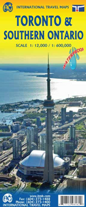
Wegenkaart - landkaart - Stadsplattegrond Toronto & Southern Ontario -

Overzichtskaart van het zuiden van Ontario - schaal 1:600.000 - met op de andere kant een grote plattegrond van Toronto op schaal 1:12.000 Legend Includes: Roads by classification, Accomodations, Museum, Churches, Buildings, Points of tourist, Public Interests, Post Offices, Police Stations, Schools, Live Theatres, Cinemas, Ruins, Bus Terminals, Fe...
13,95

Webshops met dit product

Webshop
Bezorging
Prijs

Anderen bekeken ook

Wegenkaart - landkaart - Stadsplattegrond Toronto & Southern Ontario -
Overzichtskaart van het zuiden van Ontario - schaal 1:600.000 - met op de andere kant een grote plattegrond van Toronto op schaal 1:12.000 Legend Includes: Roads by classification, Accomodations, Museum, Churches, Buildings, Points of tourist, Public Interests, Post Offices, Police Stations, Schools, Live Theatres, Cinemas, Ruins, Bus Terminals, Ferry Terminals, Service Areas, Hospitals, Ports, Mines, RCMP, Major Airports, Secondary Airports, Camp Grounds, National Park and Equivalent Reserves, Ski, Picnic Sites, and much more.   Toronto is the largest city in Canada by far. Touristically, its attraction rests with its central core, from High Park in the west to the Don River in the east, and from the park-like islands in Lake Ontario to Bloor Street in the north. In this area, one finds remnants of the oldest portion of ‘muddy York’, the original fort built to deter American raiders (close to the exhibition grounds), Campbell House (at Queen & University), and the first public school…
13,95
Wegenkaart - landkaart Southern Ontario | ITMB
Een degelijke kaart met aanduidingen van o.a. nationale parken, vliegveld, benzinepomp, dirt-roads en kleine plattegrond van hoofdstad. Als overzichtskaart goed te gebruiken. The Canadian province of Ontario is intimidatingly large. It is also mostly tundra with extremely few settlements and few roads; in fact, the geographic centre of Ontario is about 1,500 kms north of the nearest road. The very first map I prepared, at age 10, was of Ontario; and it took me six weeks to trace all the lakes. My point is that the developed portion of the province is a much smaller wedge of fertile ground south of the mineral belt of the Great Canadian Shield. This double-sided map focusses on the area south of Sudbury and North Bay and expands the scale to a much more useful purpose for most users. Imagine Detroit in the southwest corner of the map, with Highway 401 joining it to London and Toronto and a branch motorway cutting across to Buffalo. Add in the Bruce Peninsula and the major routes north t…
13,95
Wegenkaart - landkaart Ontario | ITMB
Een degelijke kaart voor Ontario met aanduidingen van o.a. nationale parken, vliegveld, benzinepomp, dirt-roads en kleine plattegrond van Toronto, Sault Ste. Marie. Als overzichtskaart goed te gebruiken. Ontario and Quebec form the portion of Canada known as Central Canada. Ontario is the industrial heartland of the country, and the southern portion is the most densely-populated and urbanized part of Canada. Toronto is a city of 2.8M people and the heartland of an economic region serving 100,000,000 people in two countries. Southern Ontario is also home for six million residents, some of the most historic sites in the country, and major recreational land masses (Algonquin Park, Bruce Trail, Muskoka/Haliburton). Northern Ontario, on the other side of the map, occupies the bulk of the land area of the province, and is dominated by the Canadian Shield (a pre-Cambrian rock formation that is the oldest land on earth, rich in mineral wealth). The North is dominated by recreational activities…
13,95
Wegenkaart - landkaart Great Lakes Region - Grote Meren | ITMB
To North Americans, there is only one "Great Lakes" - the waterway stretching far into the interior of the continent from the Gulf of St. Lawrence to the tip of Lake Superior. This vast region has exerted a fundamental hold on the development of both the USA and Canada; first as a canoeing trade route for trapping furs, then as a means of settlement, and now as a water route to move products to world markets. The region is also densely populated with well-known touristic cities and attractions, and houses in excess of 100,000,000 people. Surprisingly, until now, there has never been a map for this interesting and historic part of the continent. Using this map, one can explore Lakes Ontario and Erie as circular routes; also Huron and Superior; visit Ottawa and Toronto, Chicago and Duluth, and find Fort William or the Wawa Goose. This is a double-sided map covering from Ottawa in the north to Pittsburgh and Columbus in the south and Duluth and Thunder Bay in the west. Both Canada and the…
13,95
Wegenkaart - landkaart 3124 Great Lakes | National Geographic
Mooie kaart van de bekende kaartenmaker National Geographic. Veel details door kleurgebruik. De wegen zijn met kleuren verdeeld in drukke en minder drukke, de wegnummers zijn goed terug te vinden. De kaart onderscheidt zich van andere series door de hoeveelheid topografische details als counties, plaatsnamen en waterwegen en het bevat een register waarin het eenvoudig zoeken is. Daarnaast is de kaart gedrukt op scheur- en watervast papier.   The United States Great Lakes Adventure Map will guide you to the five Great Lakes of Superior, Michigan, Huron, Erie, and Ontario. This region of the country has used the Great Lakes as a pathway for exploration, trade and recreation for hundreds of years and these traditions still thrive as witnessed by the cities and towns that border the Great Lakes. The states of Minnesota, Wisconsin, Illinois, Michigan, Indiana, Ohio, Pennsylvania, and New York all benefit from their contact with the largest freshwater lake system on Earth. The map includes t…
17,50
Stadsplattegrond - Wegenkaart - landkaart Quito & Ecuador Central | IT
Een degelijke wegenkaart van Ecuador met aanduidingen van o.a. nationale parken, vliegveld, benzinepomp, dirt-roads en kleine plattegrond van hoofdstad. Als overzichtskaart goed te gebruiken. Finally, ITMB releases its long-awaited re-worked map of the wonderful South America city of Quito. The city is squeezed in between mountain ranges and, the entire city stretches from north (on the right-hand side of the map) to the south. The "bottom" of the map is, actually the eastern portion. A regional inset map clarifies the situation. The street network is clearly shown, along with the rapid line bus way and the city's Metro. The Old Town is perhaps the most interesting portion of the city for visitors and is on the left-hand portion of the map. The newer downtown is centered on La Carolina Park on the right-hand side of the map. This is where most of the shopping malls and hotels are located. The old airport is shown in part on the far right, but the new international airport is located fa…
13,95
Stadsplattegrond - Wegenkaart - landkaart Quebec City & Gaspe Peninsul
Een degelijke kaart aan twee kanten bedrukt. Aan de ene zijde een plattegrond van Quebec stad, schaal 1:10.000. En aan de andere zijde een wegenkaart, schaal 1:750.000, van Gaspe schiereiland met aanduidingen van o.a. nationale parken, vliegveld, benzinepomp, dirt-roads. ITMB is pleased to be introducing yet another brand new title to our line. Quebec City is one of the oldest urban areas in North America, having been continuously occupied since 1608 (unfortunately, the first attempt at settlement, in 1606, failed through poor planning, and all the settlers perished). QC is also the only completely walled city in North America and the city streets within the walls have barely changed in 400 years. The city is also linguistically unique in being almost completely French Canadian in language (Montreal is much more Anglophiled). The city was the capital of French Canada until General Wolfe and the British army arrived in 1759. The British were able to climb the cliffs protecting the city …
13,95

Klanten-reviews van Wegenkaart - landkaart - Stadsplattegrond Toronto & Southern Ontario -

Er zijn nog geen beoordelingen voor dit productBen jij de eerste die een review plaatst?

Meer over Wegenkaart - landkaart - Stadsplattegrond Toronto & Southern Ontario -

Productomschrijving

Overzichtskaart van het zuiden van Ontario - schaal 1:600.000 - met op de andere kant een grote plattegrond van Toronto op schaal 1:12.000 Legend Includes: Roads by classification, Accomodations, Museum, Churches, Buildings, Points of tourist, Public Interests, Post Offices, Police Stations, Schools, Live Theatres, Cinemas, Ruins, Bus Terminals, Ferry Terminals, Service Areas, Hospitals, Ports, Mines, RCMP, Major Airports, Secondary Airports, Camp Grounds, National Park and Equivalent Reserves, Ski, Picnic Sites, and much more.   Toronto is the largest city in Canada by far. Touristically, its attraction rests with its central core, from High Park in the west to the Don River in the east, and from the park-like islands in Lake Ontario to Bloor Street in the north. In this area, one finds remnants of the oldest portion of ‘muddy York’, the original fort built to deter American raiders (close to the exhibition grounds), Campbell House (at Queen & University), and the first public school in Canada (1807). The city is exceptionally multi-cultural, with a vibrant Chinatown just north of City Hall, Little Italy and Little Brasil bordering College Street, and Greek town along the Danforth. The Yorkville area has been a focal point for coffee shops and night clubs for more than half a century, and the university campus is one of the most-respected in the world. The Islands have been largely converted into parkland, and have ferries going to five destinations on a regular basis. The streetcar network is not just for tourists, as it is vital to Toronto’s mass transit operation, as are the subway system and GO trains serving the city centre. The other side of the sheet is equally important. Geographically, Southern Ontario juts into the American heartland to the 42nd parallel. Detroit is actually north of Windsor, and Point Pelée is south of Erie, Ohio. Most residents of Ontario live in the part of the province deemed to be ‘southern”. This map covers from Detroit/Windsor in the west to Kingston and Syracuse in the east and from Erie north to Orillia, showing lakes Huron, St. Claire, Erie, and Ontario and the border between two great nations. This is a part of North America rich in history and acts as a natural expansion point for anyone visiting Toronto.

Productspecificaties

Artikelnummer(s)
Brand
ITMB
Webshop.nl maakt gebruik van cookies. Ga je verder op onze website, ga dan akkoord met het plaatsen van cookies en de verwerking van deze data door ons en vermelde partners.