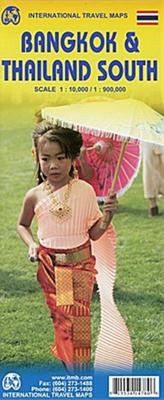
Wegenkaart - landkaart - Stadsplattegrond Thailand zuid South - Bangkok | ITMB

0
Duidelijke wegenkaart met op de ene zijde de kaart van Bangkok op een goede schaal met veel toeristische informatie. De andere kant heeft het hele zuiden van Thailand .   Bangkok is a very interesting city, with many temples, pagodas, and historic buildings. It is also an airline hub and, as a result of not being a member of IATA, is a bargain-lov...

Verkopers met dit product

Verkoper
Bezorging
Prijs
DeZwerver.nl logo
DeZwerver.nl
2,95
13,95

Anderen bekeken ook

Stadsplattegrond - Wegenkaart - landkaart Quito & Ecuador Central | ITMB
Een degelijke wegenkaart van Ecuador met aanduidingen van o.a. nationale parken, vliegveld, benzinepomp, dirt-roads en kleine plattegrond van hoofdstad. Als overzichtskaart goed te gebruiken. Finally, ITMB releases its long-awaited re-worked map of the wonderful South America city of Quito. The city is squeezed in between mountain ranges and, the entire city stretches from north (on the right-hand side of the map) to the south. The "bottom" of the map is, actually the eastern portion. A regional inset map clarifies the situation. The street network is clearly shown, along with the rapid line bus way and the city's Metro. The Old Town is perhaps the most interesting portion of the city for visitors and is on the left-hand portion of the map. The newer downtown is centered on La Carolina Park on the right-hand side of the map. This is where most of the shopping malls and hotels are located. The old airport is shown in part on the far right, but the new international airport is located f…
13,95
Wegenkaart - landkaart Indonesië - Indonesia | ITMB
Een degelijke landkaart van Indonesië met aanduidingen van o.a. nationale parken, vliegvelden en grote wegen. Als overzichtskaart goed te gebruiken. De nadruk ligt echter vooral op de natuurkundige aspecten. Scheur- en watervast! Met een kleine kaart van Jakarta. The hundreds of islands making up the island nation of Indonesia make a double-sided map inevitable in order to show any significant amount of detail. Side 1 shows the western half, starting with Sumatra in the upper left and including Java and most of the island of Borneo (Kalimantan Province to the Indonesians). This side also includes a large inset map of central Jakarta (for better detail see our separate map of the city); ditto for Sumatra, Java, and Borneo. Bali, Lombok, and Sumbawa islands are in the lower right portion of the map, and most of Malaysia and all of Singapore are included, simply because they are there. The infamous volcanic island of Krakatoa is located just to the west of Java. The other side of the map…
13,95
Stadsplattegrond Bangkok | Borch
Borch Bangkok is een duidelijke, geplastificeerde plattegrond van het centrum met informatie over openbaar vervoer en bezienswaardigheden. Inclusief straatnamenregister. Our soft-laminated folded map of Bangkok shows: Bangkok City 1:14 000, Wat Phra Kaeo & Royal Grand Palace 1:6 000, Bangkok & Region 1:100 000, Public Transport Bangkok, Top 30 Sights, Thailand administrative and time zones. Borch Maps are easy to fold, durable and water-repellent with a wipeable surface. Borch Maps show hotels, museums, monuments, markets, public transport, top sights and points of interest, useful statistics, conversion charts for temperatures, weights and measurements, climate charts showing temperatures, sunshine hours, precipitation and humidity, overview maps, time zones, and much more...   Krung Thep Maha Nakhon (Bangkok) on the Chao Phraya river is the capital city of Thailand and the country's economic center. It is one of the most populous cities in the world with its number of inhabitants ve…
9,95
Wegenkaart - landkaart Korea, North & South | ITMB
Een degelijke kaart met aanduidingen van o.a. nationale parken, vliegveld, benzinepomp en dirt-roads. Als overzichtskaart goed te gebruiken. Met Noord Korea, schaal 1:830.000, aan een kant en op de andere zijde Zuid Korea, schaal 1:550.000. This is a brand new title for ITMB, combining North and South Korea into one double-sided map focusing on the entire Korean Peninsula rather than its political components. The peninsula is undergoing a lot of change at the moment, and no one knows the ultimate outcome. North Korea seems interested in opening itself somewhat to South Koreans, and even if steps to date seem like baby ones, tensions between north and south seem cordial at the moment. For the time being, this map replaces our separate map of North Korea, as changing conditions makes it too risky for us to re-do our North Korea title until its future path is clearer. However, although this map also shows South Korea in good detail, we will continue marketing our Seoul and South Korea ma…
13,95
Wegenkaart - landkaart - Stadsplattegrond China South - Zuid | ITMB
Een degelijke wegenkaart met aanduidingen van o.a. nationale parken, vliegveld, benzinepomp, dirt-roads. Als overzichtskaart goed te gebruiken.   China is a very large country. While our map of the entire country is fine for general travel and sells well, China is too large to show areas in detail. This map concentrates on the part of China from Shanghai south and all the way west to Lhasa and includes Taiwan and Hainan Island. We are not trying to make any sort of political comment here, but geographically, both Tibet and Taiwan fall within the area of coverage and are both included for this reason alone. The map also includes insets of Hong Kong, Guangzhou and Shanghai   Legend Includes: Roads by classification, Points of Interest, National Parks, Airports, Golf Courses, Beaches, Campsites, Waterfalls, Viewpoints, Churches, Surfing/Scuba Diving Spots, Fishing Spots, Hospitals, harbours/Ports, Lighthouses, Museums, Monuments, Caves, Mosques, Mountain Peaks, Botanic Gardens, Wildlife …
13,95
Wegenkaart - landkaart Wales & south of England - Zuid Engeland | ITMB
Een degelijke kaart met aanduidingen van o.a. nationale parken, vliegveld, benzinepompen. We are gradually increasing the scales for our data of Great Britain and this is our latest effort. Most visitors to the UK fly into one of London's four airports and combine a visit to the city with an opportunity to travel to various destinations within striking distance of London. England is so incredibly rich in heritage and scenic attractions that it is extremely difficult to portray the country as a map of the entire entity. As a result, England lends itself nicely to be divided into a central/northern portion and a southern portion. To fit areas as diverse as Cornwall and Norwich on one sheet, one needs to have a vertical frame, with Devon/Cornwall up to the top of Wales on one side and Wiltshire to Kent up to York (admittedly, not normally considered to be part of 'southern', but vertically, that's what happens. At this scale, all of southern England and all of Wales can be shown in good …
13,95
Wegenkaart - landkaart Thailand | Borch
Mooie geplasticieerde kaart van Thailand. Deze kaart biedt een goed overzicht van het land met detailkaarten van o.a. Bangkok, Phuket, Ko Samui. Our soft-laminated folded map of Thailand in the 8th edition shows: Thailand 1:1 500 000, Bangkok 1:22 000, Greater Bangkok 1:125 000, Chiang Mai 1:22 000, Mae Hong Son 1:14 000, Northwest Thailand 1:835 000, Phuket 1:350 000, Ko Samui & Ko Phangan 1:350 000, Thailand administrative & time zones. Borch Maps are easy to fold, durable and water-repellent with a wipeable surface. Borch Maps show hotels, museums, monuments, markets, public transport, top sights and points of interest, useful statistics, conversion charts for temperatures, weights and measurements, climate charts showing temperatures, sunshine hours, precipitation and humidity, overview maps, time zones, and much more...   Thailand - "Country of Liberty" - has every right to its name, as it is the only southeast Asian country never to have been ruled by a western colonial power…
11,50
Wegenkaart - landkaart Thailand North - noord | ITMB
Een degelijke wegenkaart met aanduidingen van o.a. nationale parken, vliegveld, benzinepomp, dirt-roads. Als overzichtskaart goed te gebruiken.   The map actually goes from Bangkok north, and side one includes a very good inset map of Bangkok’s central area. Probably the most interesting spot on this side is the town of Kanchanaburi, which is within easy striking distance of Bangkok. This was the site made famous by the war movie Bridge on the River Kwai (now Khwae) on the Japanese-built Burma Railway. The current bridge is not the original, but the Commonwealth Graves Cemetery is well worth a visit. The other side concentrates on the wilder portion of Thailand, the far north. All known points of interest have been included, including a lovely inset map of Chiang Mai, the focal point of the north. The rail line ends here, but if the city’s many temples and pagodas don’t overwhelm you, tours to nearby temple sites abound. The temple complex near Phrae, further to the east, are also sho…
13,95
Wegenkaart - landkaart 751 Thailand | Michelin
De Michelin kaart van Thailand is een overzichtelijke landkaart waarop de toeristische sites staan aangeduid. De kaart heeft een plaatsnamenregister en een stadsplattegrond van Bangkok. De plaatsnamen staan op de kaart en in de index in het Nederlands en in het Thais. Thailand at 1:370,000 on an indexed road map from Michelin with street plans of central Bangkok and an enlargement for the capital’s environs. All place names on the map are shown in both Thai and Latin alphabet and the index is in both scripts. Road network emphasizes main routes but also clearly presents local roads, all with road numbers easy to read. Driving distances are shown on primary routes and main connecting roads; steep gradients, viewpoints, toll barriers and border crossings are marked; scenic routes are highlighted. Railway lines are included and domestic airports are marked. Symbols indicate various places of interest.  Topography is shown by relief shading with colouring for forested areas. National park…
12,95
Wegenkaart - landkaart - Stadsplattegrond San Diego - California south | ITMB
Wegenkaart en stadsplattegrond in een kaart: aan de ene zijde San Diego stadsplattegrond en op de andere kant een kaart van het zuiden van Californië. San Diego on a clear, well presented street plan from ITMB, with a transit system diagram, a road map of the city and its environs, and a street plan of central Tijuana, plus on the reverse a road map of the US/Mexico border region extending east beyond El Paso and within USA north to Las Vegas.   On one side is an indexed street plan of San Diego, covering the city’s central districts (as indicated in our coverage image), including the downtown area, the Old Town for which an enlargement is provided, Balboa Park, University Heights, the Mission Bay Park with the SeaWorld, and the city’s international airport. The plan clearly shows the MTS and other public transit stations, highlights main traffic arteries and indicates one way streets. Also marked are recommended cycle routes. Streets are annotated with selected block numbers for easi…
13,95

Klanten-reviews van Wegenkaart - landkaart - Stadsplattegrond Thailand zuid South - Bangkok | ITMB

Er zijn nog geen beoordelingen voor dit productBen jij de eerste die een review plaatst?

Meer over Wegenkaart - landkaart - Stadsplattegrond Thailand zuid South - Bangkok | ITMB

Productomschrijving

Duidelijke wegenkaart met op de ene zijde de kaart van Bangkok op een goede schaal met veel toeristische informatie. De andere kant heeft het hele zuiden van Thailand .   Bangkok is a very interesting city, with many temples, pagodas, and historic buildings. It is also an airline hub and, as a result of not being a member of IATA, is a bargain-lover city for lower-cost airfares. This updated edition includes the new airport, recently-completed transit lines, and additional information for embassies. In this edition, we have combined our city map with a travel map for the southern half of the country, which means the peninsula connecting to Malaysia and including the most-visited parts of Thailand, the beach resorts located in the vicinity of Phuket. We have also upgraded it to plastic paper, both for the tropical humidity and for durability.    Map size: 27*39"   Legend Includes: Roads by classification, motorway, expressway, provincial highway, river, national park, waterfall, tourist spot, temple, international airport, and much more...    

Verken gerelateerde categorieën

Webshop.nl maakt gebruik van cookies. Ga je verder op onze website, ga dan akkoord met het plaatsen van cookies en de verwerking van deze data door ons en vermelde partners.