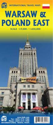
Wegenkaart - landkaart - Stadsplattegrond Poland east - Warsaw, Oost Polen en Warschau | ITMB

0
ITMB wegenkaarten en wandelkaarten kenmerken zich door het kleurgebruik waarbij zo de nadruk wordt gelegd op de natuurkundige aspecten van het land of de streek. Het soort landschap en de hoogte worden hierdoor zeer duidelijk zichtbaar. Natuurlijk vind je ook de 'gewone' zaken als wegennet, spoorwegen, vliegvelden, ferrys, toeristische bezienswaar...

Verkopers met dit product

Verkoper
Bezorging
Prijs
DeZwerver.nl logo
DeZwerver.nl
2,95
13,95

Anderen bekeken ook

Wegenkaart - landkaart Cuba east | ITMB
Goede dubbelzijdige wegenkaart waarbij met kleurgebruik de hoogte en natuurkundige aspecten wat duidelijker wordt weergegeven dan op andere kaarten. De wegen worden aangeduid met de bekende wegnummers en afstanden tussen steden staan weergegeven. Met symbolen worden toeristisch belangrijke aspecten getoond en ook bijvoorbeeld campings. Nationale parken zijn goed terug te vinden op deze kaart.  Cuba is the fastest-growing travel destination in the world. Initially, attention has favoured Havana and the western portion of the island, but tourism is rapidly transforming the eastern portion of the country into a more rustic, natural travel experience than the over-heated Varadero resorts or hectic Havana. Until now, there has never been a map of the eastern half of Cuba; now ITMB provides one! The map covers from Varadero to the easternmost tip of Guantanamo Province on a double-sided map. Insets of Varadero, Cienfuegos, Trinidad, and Santiago are included. Naturally, the road network is …
13,95
Wegenkaart - landkaart Litouwen & Letland | ITMB
ITMB is very pleased to release its first-ever map of the Baltic country of Lithuania, which occupies Side 1 of this double-sided map. It is bordered by Latvia on its north, the Russian enclave of Kalingrad on its southeast, and Poland and Belarus on its south and east. It is now on the front lines of tension between Russia and its neighbours, as are all the Baltic states. It is also a valued member of both NATO and the EU, and as such is easy to access from either Poland or Latvia. Lithuania fronts on to the Baltic Sea with a major port at Klaipeda (formerly Memel), with its capital being Vilnius. Historically, the country has suffered German and Russian invasions during the 20th century, the last of which resulted in the country losing its independence completely by being absorbed into the Russian Empire in the latter stages of WW2. It regained its independence in 1991, with the collapse of the USSR and shortly thereafter applied to join both the European Union and NATO. Touristical…
14,95
Stadsplattegrond - Wegenkaart - landkaart Quito & Ecuador Central | ITMB
Een degelijke wegenkaart van Ecuador met aanduidingen van o.a. nationale parken, vliegveld, benzinepomp, dirt-roads en kleine plattegrond van hoofdstad. Als overzichtskaart goed te gebruiken. Finally, ITMB releases its long-awaited re-worked map of the wonderful South America city of Quito. The city is squeezed in between mountain ranges and, the entire city stretches from north (on the right-hand side of the map) to the south. The "bottom" of the map is, actually the eastern portion. A regional inset map clarifies the situation. The street network is clearly shown, along with the rapid line bus way and the city's Metro. The Old Town is perhaps the most interesting portion of the city for visitors and is on the left-hand portion of the map. The newer downtown is centered on La Carolina Park on the right-hand side of the map. This is where most of the shopping malls and hotels are located. The old airport is shown in part on the far right, but the new international airport is located f…
13,95
Wegenkaart - landkaart - Stadsplattegrond Krakow - Krakau - South Poland | ITMB
Een goede stadskaart van Krakow p de ene zijde en een deel van zuid Polen op de andere kant. ITMB's third map for Poland, concentrates on the central portion of the city, with a large inset of the central pedestrian area and with a regional inset map showing roads to Auschwitz (now called Oswiecim) and to Katowice. Legend includes inter-city rail lines w/ station, Krakow tram/street-car lines, parks, plazas, accommodations, churches, synagogues, points of interest, museums, police stations, shopping centres, hospitals, pedestrian streets, bike routes, bus stations. Indexed.
13,95
Wegenkaart - landkaart Kamchatka Peninsula & Russia Far east | ITMB
Een degelijke kaart met aanduidingen van o.a. nationale parken, vliegveld, benzinepomp, dirt-roads en kleine plattegrond van hoofdstad. Als overzichtskaart goed te gebruiken. Schaal: Kamchatka 1 : 1,700.000 & Eastern Siberia 1 : 3.600.000 This is the most recently released title in our Russia series. In this revised edition, we have expanded the area of coverage to include the portion of Russia known as the Far East Republic and the eastern portions of Siberia (in January, we released Siberia itself). Lets start with the Kamchatka peninsula itself. This is a very interesting adventure travel destination, famous for its geothermal geysers and its isolation from the rest of Russia. There is only one city of any size, Petropavlovsk Kamchatsky (which I genuinely hope is colloquially known as PK), the capital and location of the peninsula only significant airport. We have included an inset map of the city. We also include a map of the famous Valley of Geysers (south of Klyuchi). Interestin…
13,95
Wegenkaart - landkaart Denver and Colorado | ITMB
Een degelijke kaart met aanduidingen van o.a. nationale parken, vliegveld, benzinepomp, dirt-roads en kleine plattegrond van hoofdstad. Als overzichtskaart goed te gebruiken. This is a brand new title for ITMB. Denver, the ‘mile-high’ city on the eastern slopes of the Rocky Mountains, is a vibrant, fairly modern city. It is the state capital, and the gold-coated dome of the legislative building highlights the wealth and strength of the state. The Denver Zoo is becoming one of the great attractions of the city, as are the Center for Performing Arts and the Museum of Science and Nature. Larimer Square is the focal point for entertainment, and Coors Field for sports. Our map shows a wide-ranging number of accommodations and eateries, and notes all points of interest. The State of Colorado map fills the reverse side of the sheet and, due to the positioning of the state’s boundaries, nicely fills the 40x28 sheet size of the map. Small portions of neighbouring states show around the edges, …
13,95
Wegenkaart - landkaart - Stadsplattegrond Istanbul & Northwest Turkey | ITMB
Dubbelzijdige kaart van ITMB met aan een kant een wegenkaart  1:550.000 met aanduidingen van o.a. nationale parken, vliegveld, benzinepomp, dirt-roads. Als overzichtskaart goed te gebruiken. Aan de andere kant een overzichtelijke stadsplattegrond 1: 11.000 met stratenindex en aanduiding van toeristische informatie en culturele instellingen zoals musea, monumenten, schouwburgen en sportaccomodaties. Daarnaast bevaten de meeste kaarten een heldere aanduiding van het openbaarvervoer (opstappunten van metro), parkeergelegenheden, postkantoren en andere praktische informatie. Istanbul is one of the most interesting cities in Europe. It is loaded with interesting places to see and places to go. The map shows all major touristic sites (my favourite is Constantine s Column), the ferry routes that criss cross the Bosphorus, and the transit lines that move everyone around the city. We have made a significant change to the regional map on the second side of the sheet; in this edition, we provide…
13,95
Spoorwegenkaart Eastern Europe Railway & Road | ITMB
Spoorwegen kaart van Oost Europa in kleur. Schaal 1:2,600,000. Toont spoorlijnen, snelwegen, secundaire wegen en andere wegen, veerboten en belangrijke scheepvaartdiensten; internationale grenzen, de grenzen van de gebieden met reisbeperkingen; bergen met de hoogte in meters. Met index van plaatsen. Schaal 1:2,600,000. . Gedrukt op twee zijden. ITMB is pleased to announce the release of the final regional map covering Europe at an enhanced scale. Europe may be small in comparison to Canada, but it is densely populated and difficult to map as a continent while providing detail. Eastern Europe used to be defined as everything behind the Iron Curtain during the Cold War, but now it encompasses everything east of Germany and Switzerland, which means that this map covers Italy, Greece and the Balkan countries, the Central European countries of Romania and Hungary and most of Ukraine, Poland and the three Baltic states, and western Russia as far east as Volgograd, as well as much of Turkey.…
13,95
Wegenkaart - landkaart Indonesië - Indonesia | ITMB
Een degelijke landkaart van Indonesië met aanduidingen van o.a. nationale parken, vliegvelden en grote wegen. Als overzichtskaart goed te gebruiken. De nadruk ligt echter vooral op de natuurkundige aspecten. Scheur- en watervast! Met een kleine kaart van Jakarta. The hundreds of islands making up the island nation of Indonesia make a double-sided map inevitable in order to show any significant amount of detail. Side 1 shows the western half, starting with Sumatra in the upper left and including Java and most of the island of Borneo (Kalimantan Province to the Indonesians). This side also includes a large inset map of central Jakarta (for better detail see our separate map of the city); ditto for Sumatra, Java, and Borneo. Bali, Lombok, and Sumbawa islands are in the lower right portion of the map, and most of Malaysia and all of Singapore are included, simply because they are there. The infamous volcanic island of Krakatoa is located just to the west of Java. The other side of the map…
13,95
Wegenkaart - landkaart Africa north east - noord oost Afrika | ITMB
This is the third ITMB title on Africa to be released using our digital data base material. As with Africa as a continental map and Africa North West, this map covers a large area and tries to do so fairly and in detail. The essential areas of coverage are Libya and Egypt in the north, with Sudan/South Sudan, Ethiopia/Eritrea in the middle, and Kenya/Uganda in the south, with a fair portion of Tanzania and Congo thrown in simply because it fits. Being a regional map, it is useful for the 'big' picture. It is quite detailed, showing roads, towns, and major touristic sites. It is more detailed and at a better scale than the Michelin map of the same name   Legend Includes: Road by classification, Main Road, National Park, Lake, Capital, International Airport, Oasis, Ruins, Hotels and much more...
13,95

Klanten-reviews van Wegenkaart - landkaart - Stadsplattegrond Poland east - Warsaw, Oost Polen en Warschau | ITMB

Er zijn nog geen beoordelingen voor dit productBen jij de eerste die een review plaatst?

Meer over Wegenkaart - landkaart - Stadsplattegrond Poland east - Warsaw, Oost Polen en Warschau | ITMB

Productomschrijving

ITMB wegenkaarten en wandelkaarten kenmerken zich door het kleurgebruik waarbij zo de nadruk wordt gelegd op de natuurkundige aspecten van het land of de streek. Het soort landschap en de hoogte worden hierdoor zeer duidelijk zichtbaar. Natuurlijk vind je ook de 'gewone' zaken als wegennet, spoorwegen, vliegvelden, ferrys, toeristische bezienswaardigheden en nationale parken er op terug.. Vaak - maar niet op alle kaarten - staat op de achterzijde een stadsplattegrond van hoofdstad of belangrijkste stad in de regio. 

Voorzijde: Oost Polen shcaal 1:650.000

Achterzijde: Warschau, schaal 1:9.000

This is, at the same time, our second edition updated map of Warsaw and a brand new title for ITMB, in that we have added a regional map of the eastern half of Poland to the second side of the map. This gives the end user two maps for the price of one by combining the many attractions of the city with its surrounding countryside. Anyone with a small amount of historical knowledge knows that Warsaw was largely destroyed during World War II. Many historic cities suffered this fate; in the case of Warsaw, the historic ‘old town’ was re-built more or less as it had been, with some road widenings changing things, and the rest of the city was re-created as a post-war urban area. The ‘old town’ is actually quite compact, so is shown in detail on an inset map, as is the greater Warsaw urban area The urban map shows rail and metro lines/stations, tram lines, churches, theatres, the enormous Soviet-era cultural centre, hotels etc. The regional map covers a very large portion of eastern Poland, from the eastern borders to Lodz, and includes the roads leading to Krakow and Gdansk; altogether, a perfect map for those using Warsaw as a base and exploring the hinterland on short trips.   Legend Includes: Highway, Railway, Other Roads, Motorway, Airports, Distance in km, Border Crossing, Ferry, Warsaw Subway, Tram, Commuter, Pedestrian Zone, National Park, River, Lake, Cities, Point of interest, Camp site, Mining, Museum, World Heritage, Shopping Centre, Cinema etc.

Verken gerelateerde categorieën

Webshop.nl maakt gebruik van cookies. Ga je verder op onze website, ga dan akkoord met het plaatsen van cookies en de verwerking van deze data door ons en vermelde partners.