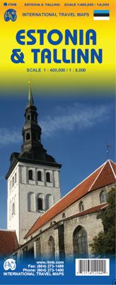
Wegenkaart - landkaart - Stadsplattegrond Estonia, Estland en Tallinn | ITMB

0
Goede wegenkaart van Estland met bezienswaardigheden, kilometers etc. daarop aangegeven. The map displays Estonia on one side and Tallin on the other, each showing a separate index. Road networks distinguish motorways, major and minor roads with intermediate distances on connecting roads. Railways and ferry routes are also shown, while symbols cle...

Verkopers met dit product

Verkoper
Bezorging
Prijs
DeZwerver.nl logo
DeZwerver.nl
2,95
13,95

Anderen bekeken ook

Nieuw
Wegenkaart - landkaart Deutschland - Duitsland | Freytag & Berndt
Gedetailleerde, eenzijdige landkaart van de Duitsland. De berijdbare wegen zijn goed weergeven, zowel de hoofdwegen als provinciale en lokale wegen; wegnummers worden vermeld. Afstanden tussen plaatsen zijn in kilometers op de kaart ingetekend, daarnaast worden ook op belangrijke plekken benzinepompen gemarkeerd. In het kaartbeeld wordt door middel van schaduw het reliëf weergegeven en soms enkele punten in het landschap met de daadwerkelijke hoogte. Provinciegrenzen zijn goed terug te vinden, nationale parken en reservaten ook. Met allerhande symbolen worden toeristische bezienswaardigheden weergegeven als monumenten, historisch belangrijke plekken en uitzichtpunten. In bepaalde plaatsen zijn hotels en campings te vinden, luchthavens, treinverbindingen en havens vindt u er ook op! Germany at 1:700,000 on a large, single-sided road map from Freytag & Berndt, with a separate extensive index booklet listing locations with postcodes and providing street plans of 18 town centres in the co…
14,95
Nieuw
Wegenkaart - landkaart South Africa: Swartberg & Klein-Karoo | Slingsby Maps
All roads from National Highways to minor gravel roads are shown; the many classifications that indi- cate the quality of each road help you plan your route No less than 28 mountain passes are shown — all are public roads! Distances are clearly shown; comprehensive 4 x 4 information GPS coordinates in DD MM SS format are provided for every road-junction All tourism facilities and accommodation establishments are shown in the out-of-town areas; there are insets of the major towns The map links to our maps of the Baviaanskloof, the Garden Route, Overberg and the Tankwa-Karoo Additional info:   Swartberg and Klein-Karoo region on a contoured and GPS compatible, double-sided, waterproof and   tear-resistant map at 1:160,000 from Slingsby Maps, with excellent topographic detail and plenty of tourist information, including street plans of ten main towns.   The map provides a very detailed picture of this mountainous terrain, with altitude colouring, shading, con- tours at 20m intervals and …
29,95
Wegenkaart - landkaart - Stadsplattegrond Fleximap Dubai | Insight Guides
Geplastificeerde centrumkaart van Dubai, met register. Voor de 'gewone' toerist een handige kaart, geen groot formaat, overzichtelijk met alle belangrijke plaatsen goed weergegeven. Flexi Map Dubai is a laminated, tear-resistant map which includes 3 maps, each accompanied by separate indexes that are categorized for ease of use. The main map depicts Central Dubai at a scale of 1:15 000 and identifies places of interest, public buildings, selected hotels, parks and shopping areas. Both main and minor roads are named, car parks and one-way systems are clearly shown. The Dubai area is shown  at a scale of 1:100 000, Main roads are named, and numbered where applicable, and the Metro system is clearly marked.  An overview map of the United Arab Emirates, at a scale of 1:1 million, shows the road network with intermediate driving distances. Points of interest are shown as well as other features, such as, water springs, coral reefs, shipwrecks and offshore oilfields.   Flexi Map Dubai also g…
9,95
Nieuw
Wegenkaart - landkaart - Stadsplattegrond San Diego - California south | ITMB
Wegenkaart en stadsplattegrond in een kaart: aan de ene zijde San Diego stadsplattegrond en op de andere kant een kaart van het zuiden van Californië. San Diego on a clear, well presented street plan from ITMB, with a transit system diagram, a road map of the city and its environs, and a street plan of central Tijuana, plus on the reverse a road map of the US/Mexico border region extending east beyond El Paso and within USA north to Las Vegas.   On one side is an indexed street plan of San Diego, covering the city’s central districts (as indicated in our coverage image), including the downtown area, the Old Town for which an enlargement is provided, Balboa Park, University Heights, the Mission Bay Park with the SeaWorld, and the city’s international airport. The plan clearly shows the MTS and other public transit stations, highlights main traffic arteries and indicates one way streets. Also marked are recommended cycle routes. Streets are annotated with selected block numbers for easi…
13,95
Wegenkaart - landkaart Costa Blanca Valencia | Marco Polo
Goede wegenkaart van een deel van Spanje,met schaal 1:200.000: meer details dan de Michelin wegenkaarten van Spanje. Deze kaarten hebben een register, een tabel met afstanden tussen steden, enkele centrumkaarten van de meest belangrijke steden, vermelding van o.a. campings aan de hand van symbolen alsmede de bezienswaardigheden. Ook benzinepompen worden bijvoorbeeld vermeld! The map boldly stresses main roads and motorways in strong colours and selected towns in large letters, but also shows minor roads and villages in considerable detail. Road information includes toll roads, traffic restrictions and seasonal closures, gradient marking for steep roads, scenic roads and special tourist routes, etc. Motorway services clearly indicate types of facilities available there. Railway network is shown with stations and includes tourist lines Picturesque towns or villages and sites worth visiting, including areas with interesting landscape, are given star rating, and other tourist information …
14,95
Nieuw
Wegenkaart - landkaart Savannah Way - Cairns to Broome | Hema Maps
Detailkaart van een deel van Australië. Zeer goed leesbaar, met naast de topografische details veel symbolen waarmee allerhande toeristische zaken worden aangeduid als campsites, nationale parken, attracties, wandelmogelijkheden etc. Find out all you need to know about travelling the Savannah Way between Cairns and Broome. As well as providing a detailed road map for the entire length of the Savannah Way, this map includes handy advice on road conditions, average rainfall and safe driving tips. The useful information also highlights the features you pass in Queensland, Northern Territory and Western Australia. Routes between Cairns and Broome in Hema’s range of very popular touring maps showing roads connecting Australia’s main centres of population along some of the most spectacular routes such as the Great Ocean Road or the Savannah Way. The maps highlight 24-hour fuel supplies, roadside rest areas, camping facilities, places of interest, etc., and include distance charts and, in so…
17,50
Nieuw
Wegenkaart - landkaart - Fietskaart Istrië - Kvarner | Kartografija
Goede kaart van Istrië en het noordelijk deel van de Kroatische kust. Op een behoorlijke schaal, geschikt voor aurto en fietsers is het gebied met helder leesbare kleuren mooi op kaart gezet. Met symbolen worden de toeristische zaken als bezienswaardigheden weergegeven, maar ook campings en havens.   Istria and Kvarner, the northern part of Croatia’s Adriatic coast, at 1:100,000 on a detailed, GPS compatible double-sided road map from Kartografija in Ljubljana highlighting picturesque locations. On one side is Istria with coverage extending north to Trieste - on the reverse the map shows the northern part of the Adriatic coast and its islands, extending south to cover all but the southernmost tip of Lošinj and approximately half of Pag.    Topography is shown by relief shading with contours at 40m intervals. Road network includes small local roads and selected cart tracks. Driving distances are shown on main and most secondary routes, and locations of border crossings and petrol stati…
12,95
Wegenkaart - landkaart D9 Sachsen | Marco Polo
Goede wegenkaart van een deel van Duitsland,met schaal 1:200.000: meer details dan de Michelin wegenkaarten van Duitsland. Deze kaarten hebben een register, een tabel met afstanden tussen steden, enkele centrumkaarten van de meest belangrijke steden, vermelding van o.a. campings aan de hand van symbolen alsmede de bezienswaardigheden. Ook benzinepompen worden bijvoorbeeld vermeld! The maps retain the publisher’s traditional cartography of this series, boldly stressing main roads and motorways in strong colours and selected towns in large letters, but also showing minor roads and villages in considerable detail. Road information includes toll roads, traffic restrictions and seasonal closures, gradient marking for steep roads, scenic routes, etc. Motorway services clearly indicate types of facilities available there. Railway network includes narrow gauge and tourist lines, cable car lines, and chair lifts. The series is particularly good for identifying geographical features: mountain a…
13,95
Wegenkaart - landkaart D6 Hessen | Marco Polo
Goede wegenkaart van een deel van Duitsland,met schaal 1:200.000: meer details dan de Michelin wegenkaarten van Duitsland. Deze kaarten hebben een register, een tabel met afstanden tussen steden, enkele centrumkaarten van de meest belangrijke steden, vermelding van o.a. campings aan de hand van symbolen alsmede de bezienswaardigheden. Ook benzinepompen worden bijvoorbeeld vermeld! The maps retain the publisher’s traditional cartography of this series, boldly stressing main roads and motorways in strong colours and selected towns in large letters, but also showing minor roads and villages in considerable detail. Road information includes toll roads, traffic restrictions and seasonal closures, gradient marking for steep roads, scenic routes, etc. Motorway services clearly indicate types of facilities available there. Railway network includes narrow gauge and tourist lines, cable car lines, and chair lifts. The series is particularly good for identifying geographical features: mountain a…
13,95
Wegenkaart - landkaart D11 Baden-Württemberg | Marco Polo
Goede wegenkaart van een deel van Duitsland,met schaal 1:200.000: meer details dan de Michelin wegenkaarten van Duitsland. Deze kaarten hebben een register, een tabel met afstanden tussen steden, enkele centrumkaarten van de meest belangrijke steden, vermelding van o.a. campings aan de hand van symbolen alsmede de bezienswaardigheden. Ook benzinepompen worden bijvoorbeeld vermeld! The maps retain the publisher’s traditional cartography of this series, boldly stressing main roads and motorways in strong colours and selected towns in large letters, but also showing minor roads and villages in considerable detail. Road information includes toll roads, traffic restrictions and seasonal closures, gradient marking for steep roads, scenic routes, etc. Motorway services clearly indicate types of facilities available there. Railway network includes narrow gauge and tourist lines, cable car lines, and chair lifts. The series is particularly good for identifying geographical features: mountain a…
13,95

Klanten-reviews van Wegenkaart - landkaart - Stadsplattegrond Estonia, Estland en Tallinn | ITMB

Er zijn nog geen beoordelingen voor dit productBen jij de eerste die een review plaatst?

Meer over Wegenkaart - landkaart - Stadsplattegrond Estonia, Estland en Tallinn | ITMB

Productomschrijving

Goede wegenkaart van Estland met bezienswaardigheden, kilometers etc. daarop aangegeven.

The map displays Estonia on one side and Tallin on the other, each showing a separate index. Road networks distinguish motorways, major and minor roads with intermediate distances on connecting roads. Railways and ferry routes are also shown, while symbols clearly indicate parking and international and domestic airports.   Topography is represented by altitude colouring and graphics locate rivers, lakes, national parks and reserves, Unesco World Heritage sites, scenic spots, hotsprings etc. Symbols mark locations of various places of interest including hotels, campsites, historic ruins, castles, beaches, ports etc. International and administrative boundaries are marked. Latitude and longitude lines are drawn at intervals of 20’.   The street plan of Tallin is a clearly laid out and extends from the Gulf of Tallin to Tallin international airport and the intercity bus station in the south, the Central railway terminal in the west and the Kadriorg Art Museum in the east. The plan clearly illustrates the different types of roads with different colours, as well as the tram, intercity rail and electric trolley bus lines. Information for tourists includes monuments, information points, shopping centres, theatres, embassies, bicycle routes, walking paths etc. Separate enlargements represent Tallin Old Town at approximately 1:4,000, Tallin public transport network and Estonia’s main roads network.   The map is annotated with historical and tourist information of places of interest, it is indexed and all place names are shown transliterated only. The multilingual legend includes English.
Webshop.nl maakt gebruik van cookies. Ga je verder op onze website, ga dan akkoord met het plaatsen van cookies en de verwerking van deze data door ons en vermelde partners.