
Wegenkaart - landkaart South America - Zuid Amerika | ITMB

0
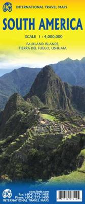
Een degelijke kaart met aanduidingen van o.a. nationale parken, vliegveld, benzinepomp, dirt-roads en kleine plattegrond van hoofdstad. Als overzichtskaart goed te gebruiken. ITMB is very pleased to release a new, digitally-prepared, double-sided map of South America. It covers the entire continent in great detail and has been able to capture the ...

Alle aanbiedingen van dit product

Verkoper
Bezorging
Prijs
DeZwerver.nl logo
DeZwerver.nl
2,95
14,95

Anderen bekeken ook

Wegenkaart - landkaart South America - Zuid Amerika | ITMB
Een degelijke kaart met aanduidingen van o.a. nationale parken, vliegveld, benzinepomp, dirt-roads en kleine plattegrond van hoofdstad. Als overzichtskaart goed te gebruiken. ITMB is very pleased to release a new, digitally-prepared, double-sided map of South America. It covers the entire continent in great detail and has been able to capture the information on the 'old' map, while using the expanded scale of the new map to add and enhance countless details that were crammed on to the earlier editions or for which there was inadequate room to include. This is the most detailed continental map of this part of the world ever published. Legend Includes: Railways, ferry routes, roads by classification, international and domestic airports, rivers, lakes, points of interest, archaeological sites, beaches, lighthouses, mines, glaciers, volcanoes, national parks and other information.  
14,95
Wegenkaart - landkaart South America Southern - Zuid Amerika, deel Zuid | ITMB
1:2,600,000 scale 6th Edition, double-sided printing. This map shows the southern third of South America in better detail than any other map.gIt starts at northern Chile, southern Paraguay, and central Brasil, and moves south to cover all of Argentina and almost all of Chile. Side 1 is a detailed road map of the region as far south as Buenos Aires. Side 2 covers Patagonia, the coast of Chile, and Tierra del Fuego. Map size: 27"X39"
14,95
Wegenatlas Travel Atlas South America - Zuid Amerika | ITMB
De eerste gedegen wegenatlas van Zuid Amerika: handig boekje met slappe kaft op A5 formaat. This is unique! ALL of the continent of South America is now available in an easy-to-read, easy-to-use, easy-to-store road atlas at a superb scale. In addition to showing each country systematically, logically, and in great detail, physical features, points of interest, beaches, reefs, parks and reserves, major airports, and roads are shown. The atlas is 5 1/2" wide by 8 1/2" high (15cmx22cm), the same size as our Mexico Road Atlas. This atlas is 112 pages in length, is fully indexed, and has a hard card cover, and a spine. The advantage of this book format is that visitors to more than one country can save money and gain ease of use through a conveniently-sized and attractively presented book format. There is nothing equivalent to this in the world!
16,95
Reisgids South America - Zuid Amerika | Lonely Planet
De bijbel voor Backpackers! Beschrijft alle landen van Zuid Amerika....De perfecte reisgids voor zowel de georganiseerde als de zelfstandige reiziger. Naast een algemene inleiding van het land / streek vol met praktische informatie over hoe je er het beste kunt reizen: slapen, eten, vervoer, excursies ... alles kun je er in vinden. Lonely Planet Lonely Planet's local travel experts reveal all you need to know to plan the trip of a lifetime in this latest edition of our guide to South America.   Discover South America's most popular experiences and best kept secrets from admiring one of Argentina's greatest natural wonders, the majestic Glaciar Perito Moreno; to taking in Patagonia's dramatic scenery on a road trip along Chile's Carretera Austral; and marvelling at the striking stone ruins of Ingapirca, Ecuador's most important archaeological site.   Build a trip to remember with Lonely Planet's South America travel guide:   Our classic guidebook format contains the most comp…
27,95
Wegenkaart - landkaart Midden Amerika - Central America | ITMB
Een degelijke kaart met aanduidingen van o.a. nationale parken, vliegveld, benzinepomp, dirt-roads. Als overzichtskaart goed te gebruiken. Met Belize, Guatemala, Honduras, El Salvador, Nicaragua, Costa Rica en Panama. Folded color road and travel map. Scale 1:1,100,000. Distinguishes roads ranging from highways (paved/unpaved) to seasonal tracks. Legend includes swamps, glaciers, reefs, active volcanoes, railways, ferry routes, protected areas/national parks, international airports, domestic airports with scheduled services, landing grounds, points of interest, ruins, lighthouses, mines, beaches, gas stations, border crossing points. Includes inset map of Panama Canal Area, Isla del Coco. Extensive index, general information on the listed countries.  
14,95
Wandkaart Zuid Amerika - South America political, 100 x 120 cm | Maps International
Fraaie politieke kaart van het continent, waarbij vooral de politieke aspecten heel duidelijk te lezen zijn. Alle landen hebben verschillende kleuren, steden en belangrijke verbindingen zijn goed te vinden. Geplastificeerde uitvoering met blauw metalen strips boven en onder de kaart waardoor deze eenvoudig is op te hangen. Maps International's South America political wall map shows all countries in South America from Venezuela and the Grenadine Islands down to Argentina and the most Southerly points of Chile and the Falkland Islands.    This political wall map of South America features countries marked in different colours, with international borders clearly shown. The map's key shows the flags from the countries displayed in this map. This South American political wall map also contains city population detail, capital cities and all the major towns and cities in this continent of South America.    Maps International's North America map is available either plain or laminated. Major mo…
49,95
Wegenkaart - landkaart South East Asia - Zuid Oost Azië | ITMB
  Een degelijke kaart met aanduidingen van o.a. nationale parken, vliegveld, benzinepomp en dirt-roads. Als overzichtskaart goed te gebruiken. Met Laos, Cambodja, Vietnam, Thailand, Maleisië, Filipijnen en Indonesië.   The part of the world from southern China, through the Indo-Chinese peninsula, and sweeping through the Indonesian archipelago to the hundreds of islands comprising the Philippines, is a fascinating part of the world to map. Countless cultures interact in this vast region - the mountain people along the Vietnamese/Laotian border, the fisherman of coastal regions and islands, the lovely and gentle Balinese, and the business-like Javanese. This is an extremely important part of the world - touristically attractive, economically thriving, and scenically unbeatable. This latest edition will be useful for anyone visiting the region. It is detailed, printed double-sided. This map has proven to be a better seller than expected, necessitating a review. We keep the same cover, s…
14,95
Wegenkaart - landkaart - Stadsplattegrond China South - Zuid | ITMB
Een degelijke wegenkaart met aanduidingen van o.a. nationale parken, vliegveld, benzinepomp, dirt-roads. Als overzichtskaart goed te gebruiken.   China is a very large country. While our map of the entire country is fine for general travel and sells well, China is too large to show areas in detail. This map concentrates on the part of China from Shanghai south and all the way west to Lhasa and includes Taiwan and Hainan Island. We are not trying to make any sort of political comment here, but geographically, both Tibet and Taiwan fall within the area of coverage and are both included for this reason alone. The map also includes insets of Hong Kong, Guangzhou and Shanghai   Legend Includes: Roads by classification, Points of Interest, National Parks, Airports, Golf Courses, Beaches, Campsites, Waterfalls, Viewpoints, Churches, Surfing/Scuba Diving Spots, Fishing Spots, Hospitals, harbours/Ports, Lighthouses, Museums, Monuments, Caves, Mosques, Mountain Peaks, Botanic Gardens, Wildlife …
14,95
Reisgids South American Handbook - Zuid Amerika | Bradt Travel Guides
De ultieme reisbijbel voor het Zuid-Amerikaanse continent. Alweer de 95 editie vol met praktische informatie, web en emailadressen, maar ook vol met culturele achtergronden van de verschillende landen. De meest complete gids, nog completer dan de Planet! Ideaal voor diegenen die langer op het continent verblijven of voor de reizigers die meerdere landen combineren. Super dikke pil met een stevige harde kaft! South America is a land of superlatives. Home to the world's longest mountain range, tallest waterfall, largest rainforest, driest desert, widest river and highest lake, it astounds with its variety. Now published by Bradt Guides, the award-winning, legendary South America Handbook holds a world record of its own as the longest-running English-language travel guidebook. This brand new, fully updated 95th edition celebrates the centenary of the Handbook, which remains as essential for travellers to South America today as it was in the 1920s.   Embark on extraordinary journeys thr…
39,95
Wegenkaart - landkaart Zuid Afrika - South Africa | ITMB
Uitstekende wegenkaart van Zuid Afrika met zowel de toeristische informatie als Nationale Parken en bezienswaardigheden, maar ook de topografische details en afstanden. Gedrukt op 'waterproof' papier. Double-sided map of South Africa printed on waterproof and tear-resistant synthetic paper, with plans of Cape Town, Johannesburg and Pretoria. The map divides the country east/west with a small overlap between the two sides. Elevation tinting in feet shows the general relief. Mountain passes are marked, but there are no spot heights. Road network includes selected local tracks, gives driving distances on major and secondary roads and indicates border crossings. Railways, major ferry connections and local airports are also shown. National parks and protected areas are marked and symbols highlight various places of interest, campsites or huts, rest houses and other tourist accommodation, beaches and diving sites, etc. Presentation of Lesotho and Swaziland is the same as for South Africa. L…
14,95

Klanten-reviews van Wegenkaart - landkaart South America - Zuid Amerika | ITMB

Er zijn nog geen beoordelingen voor dit productBen jij de eerste die een review plaatst?

Meer over Wegenkaart - landkaart South America - Zuid Amerika | ITMB

Productomschrijving

Een degelijke kaart met aanduidingen van o.a. nationale parken, vliegveld, benzinepomp, dirt-roads en kleine plattegrond van hoofdstad. Als overzichtskaart goed te gebruiken.

ITMB is very pleased to release a new, digitally-prepared, double-sided map of South America. It covers the entire continent in great detail and has been able to capture the information on the 'old' map, while using the expanded scale of the new map to add and enhance countless details that were crammed on to the earlier editions or for which there was inadequate room to include. This is the most detailed continental map of this part of the world ever published.

Legend Includes:

Railways, ferry routes, roads by classification, international and domestic airports, rivers, lakes, points of interest, archaeological sites, beaches, lighthouses, mines, glaciers, volcanoes, national parks and other information.


Productinformatie

    Verken gerelateerde categorieën

    Webshop.nl maakt gebruik van cookies. Ga je verder op onze website, ga dan akkoord met het plaatsen van cookies en de verwerking van deze data door ons en vermelde partners.