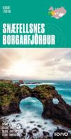
Wegenkaart - landkaart Snaefellsnes - Borgarfjordur (special map IJsland) | Ferdakort

0
Topografische overzichtskaart 1:200.000 Snæfellsnes / Borgarfjörður - special map in het westen van IJsland - Ferðakort ( vroeger Landmaelingar Íslands ) De wegenkaart laat de toeristisch interessante gebieden op het schiereiland Snaefellsnes en rond Borgarnes zien. Met verhard en onverhard wegennet hoogtelijnen, overnachtingsplekken, hutten voor ...

Verkopers met dit product

Verkoper
Bezorging
Prijs
DeZwerver.nl logo
DeZwerver.nl
2,95
21,50

Anderen bekeken ook

Nieuw
Wegenkaart - landkaart Akureyri - Mývatn - Húsavík - Ásbyrgi | Ferdakort
Topografische overzichtskaart 1:200.000 Akureyri / Mývatn / Húsavík / Ásbyrgi special map in het noorden van IJsland - Ferðakort ( vroeger Landmaelingar Íslands ) De wegenkaart laat de toeristisch interessante gebieden rond Akureyri, Husavik , het meer Myvatn en Asbyrgi met de rivier Jökulsa zien. Met verhard en onverhard wegennet hoogtelijnen, overnachtingsplekken, hutten voor wandelaars, campings, bezienswaardigheden etc. This high quality map shows the most popular tourist area in Iceland. The map includes photographs and information about the most visited places in the area. The map uses latest geographical data to produce an excellent up-to-date source of information on regional tourist attractions, roads, and services.
21,50
Wegenkaart - landkaart Explorer Map North Queensland | Hema Maps
Detailkaart van een deel van Australië. Zeer goed leesbaar, met naast de topografische details veel symbolen waarmee allerhande toeristische zaken worden aangeduid als campsites, nationale parken, attracties, wandelmogelijkheden etc. Covering Australia's beautiful North Queensland. There is alot of town map insets, tourist information, and photographs on the reverse side Touring map of the northern half of Queensland, with enlargements of popular areas, street plans, lists of facilities, etc. The main map extends south to well beyond the Flinders Highway between Townsville and Mount Isa, including Mackay on the coast. The map shows the road network, including minor roads and unsurfaced tracks, plus railways and local airfields/aerodromes. Designated Tourist Routes are highlighted and symbols mark places of interest (many annotated with brief description), historical sites, tourist resorts, youth hostels, etc. Topography is indicated by names of mountain ranges and peaks, as well as by…
17,50
Nieuw
Wegenkaart - landkaart Brisbane to Cairns | Hema Maps
Detailkaart van een deel van Australië. Zeer goed leesbaar, met naast de topografische details veel symbolen waarmee allerhande toeristische zaken worden aangeduid als campsites, nationale parken, attracties, wandelmogelijkheden etc. An easy-to-follow map that shows both the coastal and inland routes from Brisbane to Cairns. Roadside rest areas, intermediate distances, and a quick-find distance chart are also shown. The map shows all the popular tourist destinations along the Queensland coast. Routes between Brisbane with Cairns in a series of touring maps connecting Australia’s main centres of population along some of the most spectacular routes such as the Great Ocean Road or the Savannah Way. The maps highlight 24-hour fuel supplies, roadside rest areas, camping facilities, places of interest, etc., and include distance charts and, in some titles, city maps. Road network indicates unsurfaced roads and tracks. The maps also show railway lines. There is no topographical information b…
17,50
Nieuw
Wegenkaart - landkaart Mexico Central & Mexico City | ITMB
Goede wegenkaart met duidelijk kleurgebruik. Het betreft een deel van Mexico met op de achterkant een stadsplattegrond van het centrale deel van Mexico City. MC is the largest city in the Western Hemisphere, with a population of 28,000,000 (or twice as big as New York City!). It would be impractical to portray the entire urban area on one map and have it make sense, so we show the portion of greatest interest to visitors, from the Chapultepec Zoological Park in the west to the incredibly busy Tapo Bus Terminal in the east, and from the railway station in the north to the southern east-west motorway just south of the main hospital complex. Much of MC’s touristic interest is concentrated in the Zona Rosa, Reforma, and Zocalo segments of the city centre, and these are shown in detail, noting hotels, major restaurants, shopping areas, and points of interest.   The map also includes inset maps of the San Angel area just north of the university, an inset map of the greater Mexico City Feder…
13,95
Nieuw
Wegenkaart - landkaart The golden Circle - Zuidwest IJsland | Ferdakort
Hele goede wegenkaart met veel topografische details, aangepast aan de toerist / reiziger met symbolen voor allerhande bezienswaardigheden en praktische zaken als campings en benzinepompen. Quality map of the most popular tourist route in South Iceland, Gullfoss - Geysir - Þingvellir, with pictures and information of the highlights of the tour like the Blue lagoon. The map contains the latest information about Iceland's road system, including road distances and road numbers, as well as important travel-service information.
21,50
Nieuw
Wegenkaart - landkaart 3024 Adventure Map Cambodia - Cambodja | National Geographic
Mooie, heldere kaart van Cambodja,  gedrukt op scheurvast en watervast papier. National Geographic's Cambodia Adventure Map is designed to meet the needs of adventure travelers with its durability and detailed, accurate information. This map includes the locations of cities and towns with a user-friendly index, a clearly marked road network complete with distances and designations for roads/highways, plus secondary routes for those seeking to explore off the beaten path. Adventure Maps differ from a traditional road map because of the specialty content they include. Each map contains hundreds of diverse and unique recreational, ecological, cultural, and historic destinations — outside of the major tourist hubs. National Geographic Adventure Maps are the perfect companion to a guidebook, yet far easier to pack!   Cambodia is perhaps best know to international travelers as the home of the Angkor empire for six hundred years. Angkor Wat and Angkor Thom are part of the vast temple complex…
17,50
Nieuw
Wegenkaart - landkaart 12 Tour Map Scotland | Ordnance Survey
If you are on holiday and looking for a simple map containing all the information you need to make the most of your visit, the Tour maps are for you. These easy-to-read maps are packed with essential tourist information, town plans and scenic areas in addition to roads, rail, cycle routes and ground height information. These products cover popular tourist areas and are ideal for helping you to plan where to visit and how to get there. The OS Travel Map – Tour series can be used for navigating popular Long Distance Routes, coastal paths and National Trails.
10,95
Nieuw
Wegenkaart - landkaart Planning Map Australia - Australië | Lonely Planet
Durable and waterproof, with a handy slipcase and an easy-fold format, Lonely Planet Australia Planning Map is your conveniently-sized passport to traveling with ease. Get more from your map and your trip with images and information about top country attractions, itinerary suggestions, a transport guide, planning information, themed lists and practical travel tips. With this easy-to-use, full colour navigation tool in your back pocket, you can truly get to the heart of Australia, so begin your journey now! Durable and waterproof Easy-fold format and convenient size Handy slipcase Full colour and easy-to-use Before-you-go info Beautiful imagery Tailored itineraries Can't-miss regional highlights Detailed town index Transport planner Themed lists Covers Sydney, Byron Bay, Blue Mountains, Canberra, Melbourne, Goldfields, Great Ocean Road, Murray River, Brisbane, Great Barrier Reef, Whitsundays, The Daintree, Darwin, Kakadu National Park, Uluru-Kata Tjuta National Park, Hob…
10,95
Nieuw
Wandelkaart - Topografische kaart 179 OS Explorer Map | Active Gloucester / Cheltenham / Stroud | Ordnance Survey
The essential map for outdoor activities in Gloucester, Cheltenham and Stroud. The OS Explorer Map is the Ordnance Survey's most detailed folding map and is recommended for anyone enjoying outdoor activities including walking, horse riding and off-road cycling. This map now comes with a digital version which you can download to your smartphone or tablet.Providing complete GB coverage, the OS Explorer map series details information essential in the great outdoors, including youth hostels, pubs and visitor information. Rights of way, fences, permissive paths and bridleways are clearly shown, ensuring you have the best information to get the most out of your time in the countryside. FeaturesCotswold Way Severn Way Gloucestershire Way Macmillan Way Wysis WayCotswold Way (National Trail) GloucesterCheltenhamGloucester Stroud1:25 000 scale (4 cm to 1 km - 2.5 inches to 1 mile)   Met zijn 4cm voor 1 km (2 ½ cm voor 1 mijl) schaal, is de OS Explorer kaartenserie de ideale en meest gedetaillee…
25,95
Nieuw
Wandelkaart - Topografische kaart 181 OS Explorer Map | Active Chiltern Hills North | Ordnance Survey
The essential map for outdoor activities in Chiltern Hills North. The OS Explorer Map is the Ordnance Survey's most detailed folding map and is recommended for anyone enjoying outdoor activities including walking, horse riding and off-road cycling. This map now comes with a digital version which you can download to your smartphone or tablet.Providing complete GB coverage, the OS Explorer map series details information essential in the great outdoors, including youth hostels, pubs and visitor information. Rights of way, fences, permissive paths and bridleways are clearly shown, ensuring you have the best information to get the most out of your time in the countryside. FeaturesIcknield Way RidgewayNorth Buckinghamshire Way Icknield Way PathSwan's Way Two Ridges Link Aylesbury RingSouth Bucks Way Chess Valley Walk Chiltern Link Thame Valley WalkGrand Union Canal Walk Midshires Way Bledlow Circular Ride Hertfordshire Way Chiltern WayRidgeway (National Trail) Bedfordshire Buckinghamshire H…
25,95

Klanten-reviews van Wegenkaart - landkaart Snaefellsnes - Borgarfjordur (special map IJsland) | Ferdakort

Er zijn nog geen beoordelingen voor dit productBen jij de eerste die een review plaatst?

Meer over Wegenkaart - landkaart Snaefellsnes - Borgarfjordur (special map IJsland) | Ferdakort

Productomschrijving

Topografische overzichtskaart 1:200.000 Snæfellsnes / Borgarfjörður - special map in het westen van IJsland - Ferðakort ( vroeger Landmaelingar Íslands )

De wegenkaart laat de toeristisch interessante gebieden op het schiereiland Snaefellsnes en rond Borgarnes zien.

Met verhard en onverhard wegennet hoogtelijnen, overnachtingsplekken, hutten voor wandelaars, campings, bezienswaardigheden etc.

This high quality map shows the most popular tourist area in Iceland. The map includes photographs and information about the most visited places in the area. The map uses latest geographical data to produce an excellent up-to-date source of information on regional tourist attractions, roads, and services.

Verken gerelateerde categorieën

Webshop.nl maakt gebruik van cookies. Ga je verder op onze website, ga dan akkoord met het plaatsen van cookies en de verwerking van deze data door ons en vermelde partners.