Wegenkaart - landkaart Seychellen & Indische Oceaan | ITMB

0
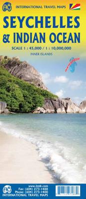
Aan de ene kant een degelijke kaart van de Seychellen, schaal 1:45.000, met aanduidingen van o.a. nationale parken, vliegveld, benzinepomp, dirt-roads. As overzichtskaart goed te gebruiken. Aan de andere kant een overzicht van de Indische oceaan, schaal 1:10.000.000   This is actually two brand new maps in one.  This is a brilliant new map of the ...

Verkopers met dit product

Verkoper
Bezorging
Prijs
DeZwerver.nl logo
DeZwerver.nl
2,95
13,95

Anderen bekeken ook

Wegenkaart - landkaart Tahiti - French Polynesia | ITMB
Anyone who has visited Tahiti retains fond memories of a wonderful Polynesian paradise. This map shows the major islands of French Polynesia as a series of large insets on Side 1. An overall inset map showing the many islands is also shown, but for showing detail, one must expand the individual islands. The largest one is the volcanic Tahiti Nui, with the capital city of Pape’ete (or Papeete in English), for which a detailed inset map is included. Most visitors stay in the vicinity of Papeete, along the coast. We show several popular resorts. There is a good circular road around the island’s shoreline, but no roads in the interior. The island is joined to another, called Tahiti Iti, or Little Tahiti, and roads extend partway around this less-developed part of the combined island. Most of the other islands are rarely visited, although they have resorts, beaches, and a lifestyle of their own. Names like Huahine, Riatea, Tahaa, and Maiao may not be as familiar as they should be, but all …
14,95
Nieuw
Wegenkaart - landkaart South Pacific Cruising & Samoa | ITMB
Een overzichtskaart van de zuidelijke Stille Oceaan met de cruise routes tussen de verschillende eilanden aangegeven. Op de achterzijde een overzichtskaart van Samoa This is a new venture for ITMB. Cruising is a rapidly-growing segment of the travel industry, experiencing double-digit growth rates annually. Obviously, this is a thriving market. In conjunction with several cruise ship lines, we have prepared a map of the South Pacific Ocean, which extends southwards from Hawai'i to the southern tip of New Zealand and eastwards from central Australia/Papua New Guinea to the Pitcairn Islands. Thus, it does not include the popular South East Asia and China coast routes. We think this has to change at a time when 25,000,000 people are travelling by cruise ships. At the same time, we must keep coverage area relevant for those end users of the artwork. Even at 1:12M, most of the area covered is water, with island countries such as Fiji, Tonga, Kiribati, Tahiti, and the Cook Islands being vis…
13,95
Nieuw
Wegenkaart - landkaart Seychelles - Seychellen | Borch
Mooie geplasticieerde kaart vande Seychellen. Deze kaart biedt een goed overzicht van het land met detailkaarten.   Our soft-laminated folded map of Seychelles shows: Bird Island, Denis, Arid, Fregate 1:25 000, Mahe, Silhouette, Praislin, La Digue, Marianne, Desroches, North 1:50 000, Inner Islands 1:750 000, Seychelles 1:4 500 000, Victoria 1:13 000, Vallée de Mai 1:13 000 and Aldabra, Amirantes, Farquhar 1:2 500 000, Seychelles time zones. Borch Maps are easy to fold, durable and water-repellent with a wipeable surface. Borch Maps show hotels, museums, monuments, markets, public transport, top sights and points of interest, useful statistics, conversion charts for temperatures, weights and measurements, climate charts showing temperatures, sunshine hours, precipitation and humidity, overview maps, time zones, and much more...   The Republic of Seychelles is an archipelago of 115 granitic and coralline islands in the Indian Ocean, located east of Africa and northeast of Madagascar. S…
11,50
Nieuw
Wegenkaart - landkaart England & Wales - Engeland | ITMB
Een degelijke kaart met aanduidingen van o.a. nationale parken, vliegveld, benzinepompen. ITMB publishes a map of Great Britain, but each portion of GB needs its own map to show roads and attractions in more detail. This is a brilliant map of both England and Wales, showing the entire 'country' in a double-sided format. The place names index is formidable, but England in particular is a series of little villages, so it has been very difficult to decide what to include and what to leave out. This map is showing motorways, divided carriageways, all A & B highways, railway lines, airports, historic sites and touristic attractions, parks and gardens, and just about everything that we could fit on to the page to provide users with a detailed, usable map. We have been able to fit all of southern England/Wales as far north as Chester/Lincoln on side A and with a little overlap, from those cities north to the well over the Scottish border, up to Perth/Dundee filling side B. The Isle of Man an…
13,95
Nieuw
Wegenkaart - landkaart 110 Milos Kimolos | Road Editions
Gedetailleerde wegenkaart met aanduiding van de wandelwegen, lijst van hotels en toeristische informatie. Voor alle doeleinden een zeer geschikte kaart. Though not among the top ten most popular destinations in the Aegean, these are two beautiful islands with a unique character, ideal for quiet family holidays, and nature touring, as well as for the young crowd looking for exciting summer fun. This is the best, most updated and easy to read map available of Milos and Kimolos. As all ROAD maps, it was designed following careful and exhaustive onsite research. We used the most advanced technology to precisely map the entire road networks of these two islands, we measured the distances in kilometers from intersection to intersection with precision instruments, marked all country churches, monasteries, archaeological sites and castles on these islands, as we did the beaches and the roads leading to them, the altitudes of mountain peaks, the footpaths we were able to locate and record, the…
9,95
Nieuw
Wegenkaart - landkaart Maui, Kauai, & Molokai | ITMB
At long last, we have finally found time to complete our detailed mapping of the American state of Hawaii. The island of Maui may not be at well-known as Oahu, which is extremely popular with Japanese honeymooners, but it is as attractive touristically. Our coverage covers most of Side 1 and includes a detailed inset map of Wailuku, the principal urban area, as well as insets of Lahaina on the west coast and Wailea resort area. This side also includes a map of the island of Lanai, with its main urban area of Lanai City as an inset. Side 2 concentrates on the islands of Molokai, Kauai, and the lightly populated island of Ni’ihau, and includes detailed inset maps of Lihue, Kaunakakai, and Po’ipu, all of which are major resort destinations. The islands are loaded with beaches and places to stay, but also with attractions, which are shown on the map. This is a beautiful map, one of the best we have ever produced, and is a fitting companion to our maps of Big Island, and Oahu/Honolulu, as …
13,95
Nieuw
Wegenkaart - landkaart Tasmania & Victoria | ITMB
Een degelijke wegenkaart van Tasmanie & Victoria, schaal 1:1.800.000, en Tasmanië, schaal 1:800.000 met aanduidingen van o.a. nationale parken, vliegveld, benzinepomp, dirt-roads. Als overzichtskaart goed te gebruiken. The island of Tasmania is Australia’s smallest state, but is packed with touristic delights. Hobart is the capital and a charming Victorian city in the south of the island. Much of the west coast is a large nature preserve with limited access and most development is close to the northern shore, centred on Devonport and its ferry connections with Melbourne, in Victoria State. Tasmania also administers several offshore islands, such as King, Flinders, and Bruny. We have included a Top Attractions listing for the reader to enjoy. The other side of the sheet is the Australian mainland state of Victoria, best known as the home of Melbourne and the beautiful coastal highway to Adelaide. A basic inset map of Melbourne is included, but the focus of the map is on the recreationa…
13,95
Nieuw
Wegenkaart - landkaart Guam - West Pacific Cruising | ITMB
Een degelijke kaart met aanduidingen van o.a. nationale parken, vliegveld, benzinepomp, dirt-roads. Als overzichtskaart goed te gebruiken. Certainly, this is the only map of Guam by any major cartographic publishing house. Here are some details: Guam is a north-south island considerably north of New Guinea, and forms part of the American-held group of islands known as the Northern Marianas. Its capital is Hagatna, and the main town is called Tamuning. The island has a well-developed international airport in the middle portion of the island, with a large US military airbase in the northeast corner. The vast majority of the island is touristic, and well worth a visit. The island was "discovered" by Ferdinand Magellan in 1521, and Hagatna is the oldest "European" city in the Pacific, dating from 1686. The town of Inarajan retains a decidedly Spanish appearance to this day. Other attractions include Tumon Beach and its many resorts, the Piti Underwater Observatory, and the famous Cocos Is…
13,95
Nieuw
Wegenkaart - landkaart Cayman Islands (Kaaiman Eilanden) & Jamaica | ITMB
Een degelijke kaart met aanduidingen van o.a. nationale parken, vliegveld, benzinepomp, dirt-roads en kleine plattegrond van verschillende steden. Als overzichtskaart goed te gebruiken. De kaart is aan twee zijden bedrukt, de ene zijde omvat de Cayman Islands (schaal 1:37.500 en 1:70.000). Op de andere zijde staat de kaart van Jamaica (schaal 1:250.000) en plattegronden van onder andere Kingston. We are pleased to announce the latest new Caribbean map to our growing series. The Caymans, for there are three major islands and numerous little shoals, remains a British colony, like the British Virgin Islands, the Turks and Caicos, and Bermuda. Tourism is the number one industry of the Cayman Islands, with dozens of hotels dotting the beachfronts, especially north of George Town. There are numerous dive sites for viewing tropical fish and we have shown about a hundred on the map, as well as every side street and gas station. One interesting place to visit is Hell, which is a frozen lava er…
13,95
Nieuw
Wegenkaart - landkaart Wales & south of England - Zuid Engeland | ITMB
Een degelijke kaart met aanduidingen van o.a. nationale parken, vliegveld, benzinepompen. We are gradually increasing the scales for our data of Great Britain and this is our latest effort. Most visitors to the UK fly into one of London's four airports and combine a visit to the city with an opportunity to travel to various destinations within striking distance of London. England is so incredibly rich in heritage and scenic attractions that it is extremely difficult to portray the country as a map of the entire entity. As a result, England lends itself nicely to be divided into a central/northern portion and a southern portion. To fit areas as diverse as Cornwall and Norwich on one sheet, one needs to have a vertical frame, with Devon/Cornwall up to the top of Wales on one side and Wiltshire to Kent up to York (admittedly, not normally considered to be part of 'southern', but vertically, that's what happens. At this scale, all of southern England and all of Wales can be shown in good …
13,95

Klanten-reviews van Wegenkaart - landkaart Seychellen & Indische Oceaan | ITMB

Er zijn nog geen beoordelingen voor dit productBen jij de eerste die een review plaatst?

Meer over Wegenkaart - landkaart Seychellen & Indische Oceaan | ITMB

Productomschrijving

Aan de ene kant een degelijke kaart van de Seychellen, schaal 1:45.000, met aanduidingen van o.a. nationale parken, vliegveld, benzinepomp, dirt-roads. As overzichtskaart goed te gebruiken. Aan de andere kant een overzicht van de Indische oceaan, schaal 1:10.000.000   This is actually two brand new maps in one.  This is a brilliant new map of the Seychelles archipelago and a first-ever map of the entire Indian Ocean. The islands of the Seychelles are too widely-spaced to portray except by as a series of ten insets. The main island is Mahe, which also houses the capital of Victoria (inset provided) and numerous resorts. Many of the islands have French names, reflecting the colonial to-and-fro that typified relations between Britain and France. Praslin, Curiuse, Falicite, La Digue, and Desroches are not names that bring immediate recognition, but they are the names of islands belonging to the Seychelles. The map shows dozens of resorts, as well as restaurants, touristic sites, historic sites, ferry docks, parks, and shopping areas. The reverse side covers the Indian Ocean as a marine map, with underwater ridges portrayed and countries portrayed politically in differing colours. The ocean nations of Comoros, Reunion, BIOT, Maldives, and Andaman/Nicobar Islands are likely only to be mapped in this context. It is an interesting map.   Legend Includes: Roads by classification, Rivers and Lakes, National Park, Airports, Points of Interests, Highways, Main Roads, Zoos, Fishing, and much more...


Verken gerelateerde categorieën

Webshop.nl maakt gebruik van cookies. Ga je verder op onze website, ga dan akkoord met het plaatsen van cookies en de verwerking van deze data door ons en vermelde partners.