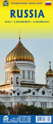
Wegenkaart - landkaart Rusland - Russia | ITMB

0
Een degelijke kaart met aanduidingen van o.a. nationale parken, vliegveld, benzinepomp, dirt-roads en kleine plattegrond van hoofdstad. Als overzichtskaart goed te gebruiken. Het westen van Rusland, tot aan Jekaterinenburg en Moermansk, op een schaal van 1:3.200.000 Het oosten van Rusland op een schaal van 1:6.300.000...

Verkopers met dit product

Verkoper
Bezorging
Prijs
DeZwerver.nl logo
DeZwerver.nl
2,95
13,95

Anderen bekeken ook

Wegenkaart - landkaart - Stadsplattegrond Reykjavik & Iceland Southwest | ITMB
Een dubbelzijdige kaart met aan de ene kant een plattegrond van Reykjavík, schaal 1:10.000. Aan de andere zijde een overzichtskaart van zuidwest Ijsland, schaal 1:330.000, met aanduidingen van o.a. nationale parken, vliegveld, benzinepomp, dirt-roads.  Stads- en regiokaart van Reykjavik en Zuidwest-IJsland Met trots kondigen wij een gloednieuwe kaarttitel van ITMB aan: Reykjavik en Zuidwest-IJsland. Reykjavik, de hoofdstad van IJsland, is een fascinerende bestemming op zich. Op deze gedetailleerde stadskaart is Reykjavik op de voorzijde van het blad afgebeeld, inclusief het internationale vliegveld – de belangrijkste toegangspoort tot IJsland – en een uitgebreid overzicht van hotels. Dat is geen overbodige luxe, gezien het bloeiende toerisme in het land.   Het stadscentrum is helder in kaart gebracht, met een schaal die het mogelijk maakt de plattegrond te voorzien van het ‘footprint’-overzicht van alle gebouwen. Ook bevat de kaart een overzicht van de belangrijkste bezienswaardighede…
13,95
Wegenkaart - landkaart Kamchatka Peninsula & Russia Far east | ITMB
Een degelijke kaart met aanduidingen van o.a. nationale parken, vliegveld, benzinepomp, dirt-roads en kleine plattegrond van hoofdstad. Als overzichtskaart goed te gebruiken. Schaal: Kamchatka 1 : 1,700.000 & Eastern Siberia 1 : 3.600.000 This is the most recently released title in our Russia series. In this revised edition, we have expanded the area of coverage to include the portion of Russia known as the Far East Republic and the eastern portions of Siberia (in January, we released Siberia itself). Lets start with the Kamchatka peninsula itself. This is a very interesting adventure travel destination, famous for its geothermal geysers and its isolation from the rest of Russia. There is only one city of any size, Petropavlovsk Kamchatsky (which I genuinely hope is colloquially known as PK), the capital and location of the peninsula only significant airport. We have included an inset map of the city. We also include a map of the famous Valley of Geysers (south of Klyuchi). Interestin…
13,95
Wegenkaart - landkaart Wit Rusland - Belarus | ITMB
Een degelijke kaart met aanduidingen van o.a. nationale parken, vliegveld, benzinepomp, dirt-roads en kleine plattegrond van hoofdstad. Als overzichtskaart goed te gebruiken. Folded travel map. Color changes show elevations. Shows roads and highways, settlements of all sizes including abandoned settlements, physical features and places of interest. Distinguishes roads from highways to unpaved roads, with distances in kilometers; railways; navigable canals; river ports; airports; churches; castles; palaces; places of interest. Includes index of places. Main map scale 1:600,000. With Minsk city center map (1:15,000) showing transit stations; information centers; museums; theaters; churches; places of interest; hotels; restaurants; embassies; more. Distances in kilometers.
13,95
Wegenkaart - landkaart Somalië & Hoorn van Afrika | ITMB
Een degelijke kaart met aanduidingen van o.a. nationale parken, vliegveld, benzinepomp, dirt-roads en kleine plattegrond van hoofdstad. Als overzichtskaart goed te gebruiken. Met aan de ene zijde een kaart van Somalië, schaal 1:1.700.000, en op de andere zijde een overzichtskaart van de Hoorn van Afrika, schaal 1:3.400.000 Somalia is one of the more interesting off-the-beaten-path countries. The area around Mogadishu prefers to call itself Somalia, but controls only a portion of the overall country area. Then there is Jubaland, on the Kenyan border, aligned very closely to the former Italian colony boundaries of the same name. Truly, an amazing juxtaposition of countries within countries! The reverse side of the sheet presents a very interesting regional perspective of the area between the northern border of Ethiopia, a small portion of Sudan and a reasonable portion of South Sudan, all of Uganda, most of Kenya, all of Djibouti, and a fair portion of Eritrea, as well as the former Ade…
13,95
Wegenkaart - landkaart Malawi - Mozambique | ITMB
Een degelijke kaart met aanduidingen van o.a. nationale parken, vliegveld, benzinepomp, dirt-roads en kleine plattegrond van de belangrijkste steden. Er was zelfs nog plek voor interessante informatie over beide landen. Als overzichtskaart goed te gebruiken. Eén zijde van de kaart omvat Mozambique in zijn geheel, met ten dele de omringende landen (schaal 1:1.900.000) De andere zijde omvat Malawi, schaal 1:900.000.   Both of these countries are unique ITMB titles. Malawi sells quite well, and always has. Mozambique is an interesting country that I explored several times while living in then-Rhodesia. Its infrastructure has suffered since independence, but Beira and the parks east of Malawi are quite good. The northern part of the country is largely undeveloped, unlike Malawi, where one of the treats of the country is Livingstonia, on a plateau overlooking Lake Malawi, where David Livingstone founded his mission and built a town of Scottish stone buildings. It has to be seen to be belie…
13,95
Wegenkaart - landkaart Saint Lucia & Martinique | ITMB
Een degelijke kaart van Saint Lucia, schaal 1:45.000, en Martinique, schaal 1:65.000, met aanduidingen van o.a. nationale parken, vliegveld, benzinepomp, dirt-roads en kleine plattegrond van hoofdstad. Als overzichtskaart goed te gebruiken. Legend Includes: Roads by classification, Highways , Main Roads, Minor Roads, Dirt Roads, Hiking Trails, Larger Urban Areas, Smaller Urban Areas, Parks, UNESCO World Heritage Sites, Diving / Scuba Locations or Dive-shops, Points of Interest / Churches, Hotels / Accommodations, Gas / Petrol Stations, Marinas / Sea Ports / Watersports, Coral Reefs, Camping / Hot Springs / Caves, Park Areas, Industrial / Parking, Institutional Areas, Attractions / Shopping, Cruise Ship Terminals / Shopping / Restaurants, Police Stations / Post Offices / Churches, Hospitals / Embassies / Schools, Regional Boundaries and more.
13,95
Wegenkaart - landkaart Kazachstan & Usbekistan | ITMB
Een degelijke kaart met aanduidingen van o.a. nationale parken, vliegveld, benzinepomp, dirt-roads en kleine plattegrond van hoofdstad. Als overzichtskaart goed te gebruiken. Kazachstan 1:3.000.000 Usbekistan schaal 1:1.580.000 The Stans of the former Soviet empire are difficult to map because in the aftermath of liberation, most place names, which the Russian overlords had Russified were changed and not always to their original names or former spellings. Time has sorted out most nomenclature problems, and we hope that this version is letter perfect. In this updated edition for both countries, we have obviously tried our best to create a detailed and accurate map. The big difference between this edition and the previous one is the addition of Uzbekistan to the second side. The two countries seem to share certain common characteristics, as do the other three more easterly Stans, so we feel that combining similarities is better for end users than keeping separate sheets for each country…
13,95
Wegenkaart - landkaart Honolulu and Oahu | ITMB
Een degelijke kaart met aanduidingen van o.a. nationale parken, vliegveld, benzinepomp, dirt-roads en kleine plattegrond van hoofdstad. As overzichtskaart goed te gebruiken. Schaal: - Oahu 1:80.000 - Honolulu 1:18.000 Honolulu/Waikiki is a brand new map for ITMB, and our first new title for a part of the USA this year. Almost everyone flying to Hawaii goes to Honolulu, and the vast majority stay in hotels located close to Waikiki Beach. This is quite a comprehensive city plan map for the Honolulu urban area, stretching from east of Diamond Head to the international airport. It also includes a large inset of the Pearl Harbour area, with its many memorials to the ships sunk during the surprise Japanese attack on December 6, 1941. Ford Island is still a major US military base. Our Top Attractions list shows the highlights of touristic interest. The second side is a newly-updated version of our map of the island of Oahu. Although the focus of this map is on Honolulu, most visitors include…
13,95
Wegenkaart - landkaart Bahrain & Qatar | ITMB
Een degelijke kaart met aanduidingen van o.a. nationale parken, vliegveld, benzinepomp, dirt-roads en kleine plattegrond van hoofdstad. Als overzichtskaart goed te gebruiken.  Schaal: - Bahrein 1:115.000 - Qatar 1:300.000 The northern portion of the United Arab Emirates consists of a small peninsula (Qatar) and an island (Bahrain). Although these countries are not geographically significant in relation to their neighbours, they are enormously wealthy, thanks to oil, and have aspirations of grandeur. Qatar hosted the FIFA World Cup of soccer in November 2022. This is significant. Qatar, as a destination country, is now 'on the map'. Its capital, Doha, is quite well developed, with three Metro subway lines, motorways, and a sophisticated city centre dominated by superb high-rise architecture. Just to the west, the island of Bahrain is just as wealthy, and just as likely to have ornate architecture, luxurious shopping arcades, and an extravagant lifestyle. Its capital, Manama, is growing…
13,95
Wegenkaart - landkaart Brazilië | ITMB
Een degelijke kaart met aanduidingen van o.a. nationale parken, vliegveld, benzinepomp, dirt-roads en kleine plattegrond van hoofdstad. Als overzichtskaart goed te gebruiken. Brazil, or more properly, Brasil, is a difficult country to map as a country, in that most of the developed areas are in the relatively small extreme south of the country. The vast region of the Amazon Basin is lightly populated and is not easy to access. Our solution has been to portray the south portion on one side at a detailed scale, to enable such locations as Rio and Sao Paulo a better scale to help travellers, while mapping the north at a respectable but more limited scale on the That said, one still needs both sides of the map, as Brasilia, the capital, falls on the north side other side of the sheet. I should also note that roads north of Brasilia tend to be less well-paved than those in the south. The  shape of the country also presents mapping difficulties, in that little room is available for inset ma…
13,95

Klanten-reviews van Wegenkaart - landkaart Rusland - Russia | ITMB

Er zijn nog geen beoordelingen voor dit productBen jij de eerste die een review plaatst?

Meer over Wegenkaart - landkaart Rusland - Russia | ITMB

Productomschrijving

Een degelijke kaart met aanduidingen van o.a. nationale parken, vliegveld, benzinepomp, dirt-roads en kleine plattegrond van hoofdstad. Als overzichtskaart goed te gebruiken.

Het westen van Rusland, tot aan Jekaterinenburg en Moermansk, op een schaal van 1:3.200.000

Het oosten van Rusland op een schaal van 1:6.300.000

Verken gerelateerde categorieën

Webshop.nl maakt gebruik van cookies. Ga je verder op onze website, ga dan akkoord met het plaatsen van cookies en de verwerking van deze data door ons en vermelde partners.