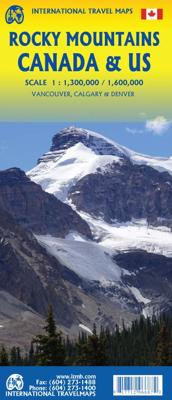
Wegenkaart - landkaart Rocky Mountains of Canada & US | ITMB

0
Een degelijke wegenkaart met aanduidingen van o.a. nationale parken, vliegveld, benzinepomp, dirt-roads. Als overzichtskaart goed te gebruiken. Aan de ene zijde de Rocky Mountains in Canada, schaal 1:1.300.000 en aan de andere zijde de Rocky Mountains in de Verenigde Staten, schaal 1:1.600.000...

Verkopers met dit product

Verkoper
Bezorging
Prijs
DeZwerver.nl logo
DeZwerver.nl
2,95
13,95

Anderen bekeken ook

Wegenkaart - landkaart USA Rocky Mountains | ITMB
This is the latest American regional map that ITMB has published. This one covers Montana, Wyoming, Colorado, and parts of Idaho, New Mexico, and Arizona. It is, of course, the southern extension of the Canadian Rockies map through Blue Sky Montana and Mile High Denver. This is a double-sided map concentrating on roads and road quality, parks, touristic attractions, and urban areas. We feel that the state-by-state approach to mapping the USA just does not work well. With todays infrastructure and vehicular capability, one can pass through three or four states in a normal day drive.  Legend Includes: Roads by classification, US Divided Highway, Mountain peak, State park, National park, Ferry Route, Historic Route 66, Hot Spring, Museum, Skiing, Beach, Cave and much more.
13,95
Wegenkaart - landkaart 3120 Rocky Mountains | National Geographic
Mooie kaart van de bekende kaartenmaker National Geographic. Veel details door kleurgebruik. De wegen zijn met kleuren verdeeld in drukke en minder drukke, de wegnummers zijn goed terug te vinden. De kaart onderscheidt zich van andere series door de hoeveelheid topografische details als counties, plaatsnamen en waterwegen en het bevat een register waarin het eenvoudig zoeken is. Daarnaast is de kaart gedrukt op scheur- en watervast papier. The United States Rocky Mountains Adventure Map will guide you through one of the most rugged and scenic regions in North America. Colorado, Utah, Wyoming, and Montana contain Yellowstone, Grand Teton, Glacier, Zion, Arches, Capitol Reef, Canyonlands, Mesa Verde, and Rocky Mountain National Parks along with dozens of magnificent National Monuments, Forests, and Wilderness Areas, the Continental Divide, and America’s greatest skiing, rafting, and climbing destinations. The map includes the cities of Denver, Salt Lake City, and Missoula, and Cheyenne …
17,50
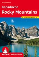
Wandelgids Kanadische Rocky Mountains - Canada | Rother Bergverlag
Uitstekende wandelgids met een groot aantal dagtochten in dal en hooggebergte. Met praktische informatie en beperkt kaartmateriaal! Wandelingen in verschillende zwaarte weergegeven in rood/blauw/zwart. Gigantische Berge, tiefblaue Seen und endlose Wälder – die Kanadischen Rocky Mountains faszinie-ren. Nur punktuell ist die raue Gebirgskette von Menschenhand berührt. Die »Rockies« vereinen felsige, windumtoste Gipfel, massive Gletscher, idyllische Bergseen, alpine Wildblumenwiesen und mystische, mit Flechten verhangene Wälder, in denen Orchideen gedeihen. Elche und Bären, Pumas und Kolibris haben in dieser wilden Schönheit ihre Heimat. Der Rother Wanderführer »Kanadische Rocky Mountains« stellt 55 Tages- und Mehrtagestouren in dieser unvergleichlichen Bergwildnis vor.   Die Highlights sind die Mehrtagestouren, die fernab von jeder Straße in die atemberaubende Natur führen. Hier kann man tagelang unterwegs sein, entlang von eisblauen Flüssen trekken, einsame Täler erkunden und wohl kaum…
22,50
Wegenkaart - landkaart British Columbia South (Canada) | ITMB
Deze wegenkaart van British Columbia bestrijkt het gebied tussen Vancouver en Calgary, en is de perfecte toeristische kaart voor het verkennen van de regio Rocky Mountain. Alle wegen en spoorlijnen tussen de twee steden worden getoond, evenals campings en parken.   This map covers the area between Vancouver and Calgary, and is the perfect tourist map for exploring the Rocky Mountain region. All roads and rail lines between the two cities are shown, as well as camp grounds, parks. Legend Includes: Points of interests, airports, RV and camping sites, wilderness camps, picnic areas, waterfalls, tourist information, museums, golf courses, gas stations, outdoor activities and other information. Folded paper, road and travel map in color. Scale 1:900,000. Distinguishes roads ranging from divided highways to other roads-4WD/dry weather. Legend includes railways, trails, ferry routes, glaciers, points of interest, international airports, domestic airports, museums, mountain peaks, camping/rec…
13,95
Wegenkaart - landkaart Bhutan & Northeast India | ITMB
Een degelijke kaart met aanduidingen van o.a. nationale parken, vliegveld, benzinepomp, dirt-roads en kleine plattegronden van Thimphu, Paro en Calcutta. Als overzichtskaart goed te gebruiken.   De ene kant van de kaart heeft Bhutan erop staan, met een schaal van 1:35.000. De andere kant van de kaart omvat noordoost India. Schaal 1:1.300.000    Bhutan is a beautiful mountainous country, squeezed between India and China. It is not a part of the world experiencing significant change, and this version is pretty much the same as our previous one, although updated with minor changes. Printed double-sided, with Northeast India on the other side.   Legend Includes: Roads by classification, Express Way, National Highway, Major Highway, Secondary Road, Other road/track, Railway, Ferry Route , State Boundary, Undefined Boundary, River and Lake, Glacier, Desert/ swamp, Mountain peak, Pass, Historical Site, Monument, Bhuddist Monument, Radio Tower, Post Office, Police Station, Hospital, Library, …
13,95
Wegenkaart - landkaart Canada | ITMB
Een degelijke kaart met aanduidingen van o.a. nationale parken, vliegveld, benzinepomp, dirt-roads en kleine plattegrond van hoofdstad. Well, it’s about time, eh?!? ITMB, after only thirty years on the go, finally gets around to publishing a map of Canada. When we first started mapping, there was a pressing need for good maps of Central and South America, then of Africa, then etc etc and we never found time to concentrate on our own country until fairly recently. This map was prepared by Natural Resources Canada and is, as a result, as accurate a map as one could hope to have. We are very proud of it, and very pleased to be able to use such top-rate cartography. The map covers all of the land mass of Canada, from its southernmost point to the top of Ellesmere Island and from the Atlantic coast to the Pacific. It’s an excellent map, but I’m going to give one proviso. Canada is the second-largest country on the face of the planet and there is no way that a single-sided sheet can portray…
13,95
Wegenkaart - landkaart Western Canada | ITMB
Een degelijke kaart met aanduidingen van o.a. nationale parken, vliegveld, benzinepomp, dirt-roads. Als overzichtskaart goed te gebruiken. This is actually our second attempt at mapping the western portion of Canada; the first covered everything from northwestern Ontario to the Pacific Ocean and, while it was an excellent map, the scale that such a huge area covered necessitated severe problems. In this version, all of British Columbia, Alberta, and the Yukon have been mapped from fresh digital data and presented at 1:1.4T scale. This would have been impossible when we prepared the first map. The Northwest Territories portion had to be compressed in two ways; first, the scale is 1:2M; second, only the portion with roads is shown. This is still an extremely large area. One has to consider the actual size of Canada when designing a map. Most countries in Europe would fit into this area, which only covers 20% of Canada. The Fort McMurray forest fire of a year ago covered an area larger t…
13,95
Wegenkaart - landkaart The Andes | ITMB
Een degelijke wegenkaart van de hele Andes met aanduidingen van o.a. nationale parken, vliegveld, Als overzichtskaart goed te gebruiken. We are pleased to be able to re-introduce this important title into our publishing range after a lapse caused by Covid. The Andes mountain chain is the southern extension of the Sierra Nevada chain through Mexico and Central America, which is, in turn the southern extension of the Rocky Mountain chain from Alaska to the Mexican border. The Andes is a magnificent series of high mountains that enters Colombia and spreads southwards through Ecuador and Peru all the way to southern Patagonia. The map is double-sided, with the Northern Andes on one side and the other side divided into two side-by-side maps portraying the Central Andes and the Southern Andes. Thus, the map coverage focuses on the Andes themselves, rather than on all of South America. All of Colombia and Peru are shown, most of Bolivia, all of Chile, and the Patagonian portion of Argentina …
13,95

Klanten-reviews van Wegenkaart - landkaart Rocky Mountains of Canada & US | ITMB

Er zijn nog geen beoordelingen voor dit productBen jij de eerste die een review plaatst?

Meer over Wegenkaart - landkaart Rocky Mountains of Canada & US | ITMB

Productomschrijving

Een degelijke wegenkaart met aanduidingen van o.a. nationale parken, vliegveld, benzinepomp, dirt-roads. Als overzichtskaart goed te gebruiken.

Aan de ene zijde de Rocky Mountains in Canada, schaal 1:1.300.000 en aan de andere zijde de Rocky Mountains in de Verenigde Staten, schaal 1:1.600.000

Productinformatie

    Verken gerelateerde categorieën

    Webshop.nl maakt gebruik van cookies. Ga je verder op onze website, ga dan akkoord met het plaatsen van cookies en de verwerking van deze data door ons en vermelde partners.