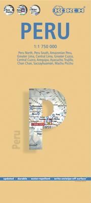
Wegenkaart - landkaart Peru | Borch

0
Mooie geplasticieerde kaart van Peru. Deze kaart biedt een goed overzicht van het land met detailkaarten.   Our soft-laminated folded map of Peru shows: Peru North 1:1 750 000, Peru South 1:1 750 000, Amazonian Peru 1:2 500 000, Central Lima 1:18 000, Greater Lima 1:150 000, Central Cuzco 1:12 000, Greater Cuzco 1:50 000, Ayacucho 1:20 000, Arequi...

Verkopers met dit product

Verkoper
Bezorging
Prijs
DeZwerver.nl logo
DeZwerver.nl
2,95
11,50

Anderen bekeken ook

Wegenkaart - landkaart Peru | Borch
Mooie geplasticieerde kaart van Peru. Deze kaart biedt een goed overzicht van het land met detailkaarten.   Our soft-laminated folded map of Peru shows: Peru North 1:1 750 000, Peru South 1:1 750 000, Amazonian Peru 1:2 500 000, Central Lima 1:18 000, Greater Lima 1:150 000, Central Cuzco 1:12 000, Greater Cuzco 1:50 000, Ayacucho 1:20 000, Arequipa 1:17 000, Chan Chan 1:40 000, Trujillo 1:20 000, Sacsayhuaman 1:10 000, Machu Picchu 1:44 000, Peru administrative & time zones. Borch Maps are easy to fold, durable and water-repellent with a wipeable surface. Borch Maps show hotels, museums, monuments, markets, public transport, top sights and points of interest, useful statistics, conversion charts for temperatures, weights and measurements, climate charts showing temperatures, sunshine hours, precipitation and humidity, overview maps, time zones, and much more...   Bordering Brazil, Bolivia, Chile, Colombia, Ecuador and the Pacific Ocean, the Republic of Peru is the cradle of the Inca …
11,50
Wegenkaart - landkaart Chile - Chili | Borch
Mooie geplasticieerde kaart van Chili. Deze kaart biedt een goed overzicht van het land met detailkaarten. Our soft-laminated folded map of Chile shows: Northern Chile, Central Chile, Southern Chile & Patagonia 1:2 000 000, Torres del Paine National Park 1:240 000, Robinson Crusoe Island 1:200 000, Easter Island (Rapa Nui) 1:160 000, Punta Arenas, Antofagasta, Iquique 1:15 000, Valparaiso 1:10 000, Arica 1:16 000, La Serena 1:13 000, Vina del Mar 1:22 000, Santiago 1:20 000 and Chile administrative & time zones. Borch Maps are easy to fold, durable and water-repellent with a wipeable surface. Borch Maps show hotels, museums, monuments, markets, public transport, top sights and points of interest, useful statistics, conversion charts for temperatures, weights and measurements, climate charts showing temperatures, sunshine hours, precipitation and humidity, overview maps, time zones, and much more...   The Republic of Chile is a long and narrow coastal strip on the western side of the S…
11,50
Wegenkaart - landkaart Aruba | Borch
Mooie, geplastificeerde kaart van Aruba. Deze kaart biedt een goed overzicht van het land met detailkaarten.   Our soft-laminated folded map of Aruba shows: Aruba 1:50 000, Beaches 1:25 000, Oranjestad 1:10 000, San Nicolas 1:20 000, ABC Islands 1:1 000 000, Lesser Antilles 1:7 000 000, Lesser Antilles time zones. Borch maps are easy to fold, durable and water-repellent with a wipeable surface. Borch Maps show hotels, museums, monuments, markets, public transport, top sights and points of interest, useful statistics, conversion charts for temperatures, weights and measurements, climate charts showing temperatures, sunshine hours, precipitation and sea temperatures, overview maps, time zones, and much more...   Aruba is the westernmost of the "ABC" islands (Aruba, Bonaire, Curaçao) and approximately 30 km off the coast of Venezuela. Sun-aficionados know these islands are home to probably the most beautiful sand beaches of the Caribbean. Wind and water conditions are ideal for the inte…
11,50
Wegenkaart - landkaart Cuzco Region - Cuzco & Peru South | ITMB
Een degelijke kaart met aanduidingen van o.a. nationale parken, vliegveld, benzinepomp, dirt-roads en kleine plattegrond van Cuzco excellent inset maps of Machu Picchu (schema), Inca Trail-scale 1:50,000, Cuzco-scale 1:11,000 and Lima-scale 1:13,500 to assist visitors – add a detailed map of the southern portion of Peru. Now, one map will cover all the routes to Cuzco, as well as the gem of South America – Machu Picchu! Legend Includes: Roads by classification, Inca trail, settlements, campings, parks, ruins, museums, accommodation, theatres, markets, bus stop, world heritage sites, Inca culture, tourist information, points of interest and other information
13,95
Wegenkaart - landkaart Ecuador | Borch
Mooie geplasticieerde kaart van Ecuador. Deze kaart biedt een goed overzicht van het land met detailkaarten.   Our soft-laminated folded map of Ecuador shows: Ecuador West 1:1 000 000, Ecuador Est 1:2 000 000, Galapagos Islands1:1 300 000, Gran Quito 1:100 000, Quito 1:20 000, Cuenca 1:17 000, Guayaquil 1:18 000, Ecuador administrative and times zones. Borch maps are easy to fold, durable and water-repellent with a wipeable surface. Borch Maps show hotels, museums, monuments, markets, public transport, top sights and points of interest, useful statistics, conversion charts for temperatures, weights and measurements, climate charts showing temperatures, sunshine hours, precipitation and humidity, overview maps, time zones, and much more...   Dominated by the towering Andean range, Ecuador is a country of magnificent highlands, dramatic slopes, dense rainforests, fertile lowlands and tranquil sandy beaches. Its immense variety of landscapes and habitats support a unique flora and fauna …
11,50
Wegenkaart - landkaart Belize | Borch
Mooie, geplastificeerde kaart van Belize. Deze kaart biedt een goed overzicht van het land met detailkaarten.   Our soft-laminated folded map of Belize in the 5th edition shows: Belize 1:500 000, Belize City 1:13 000, San Ignacio & Santa Elena 1:25 000, Yucatan Peninsula 1: 2 750 000, Ambergris Caye & Caye Caulker 1:250 000, the Maya sites Altun Ha 1:3 000, Cahal Pech 1:2 500, Caracol 1:7 000, Cerros 1:4 000, El Pilar 1:8 000, Lamanai 1:9 000, Lubaantun 1:5 000, Nim Li Punit 1: 7 000, Xunantunich 1:7 000 and Belize administrative. Borch Maps are easy to fold, durable and water-repellent with a wipeable surface. Borch Maps show hotels, museums, monuments, markets, public transport, top sights and points of interest, useful statistics, conversion charts for temperatures, weights and measurements, climate charts showing temperatures, sunshine hours, precipitation and humidity, overview maps, and much more...   Known as British Honduras until about 1973, Belize is today no longer a Bri…
11,50
Wegenkaart - landkaart Cuba | Borch
Mooie geplasticieerde kaart van Cuba. Deze kaart biedt een goed overzicht van het land met detailkaarten. Our soft-laminated map of Cuba includes: Cuba West 1:1 000 000, Cuba East 1:1000 000, La Habana 1:16 000, Varadero 1:25 000, Playas del Este 1:22 000, Santiago de Cuba 1:16 000, Cuba administrative & time zones. Borch Maps are easy to fold, durable and water-repellent with a wipeable surface. Borch Maps show hotels, museums, monuments, markets, public transport, top sights and points of interest, useful statistics, conversion charts for temperatures, weights and measurements, climate charts showing temperatures, sunshine hours, precipitation and humidity, overview maps, time zones, and much more...   The largest island in the Caribbean evokes images of blue, crystal-clear waters lapping against immaculate white beaches or revealing the colourful underwater life of the stunning reefs, cool courtyards enclosed by colonial buildings, stylish barmen mixing exotic, potent cocktails, an…
11,50
Wegenkaart - landkaart Thailand | Borch
Mooie geplasticieerde kaart van Thailand. Deze kaart biedt een goed overzicht van het land met detailkaarten van o.a. Bangkok, Phuket, Ko Samui. Our soft-laminated folded map of Thailand in the 8th edition shows: Thailand 1:1 500 000, Bangkok 1:22 000, Greater Bangkok 1:125 000, Chiang Mai 1:22 000, Mae Hong Son 1:14 000, Northwest Thailand 1:835 000, Phuket 1:350 000, Ko Samui & Ko Phangan 1:350 000, Thailand administrative & time zones. Borch Maps are easy to fold, durable and water-repellent with a wipeable surface. Borch Maps show hotels, museums, monuments, markets, public transport, top sights and points of interest, useful statistics, conversion charts for temperatures, weights and measurements, climate charts showing temperatures, sunshine hours, precipitation and humidity, overview maps, time zones, and much more...   Thailand - "Country of Liberty" - has every right to its name, as it is the only southeast Asian country never to have been ruled by a western colonial power…
11,50
Wegenkaart - landkaart Frankrijk | Borch
Mooie geplasticieerde kaart van Frankrijk. Deze kaart biedt een goed overzicht van het land met detailkaarten. Our soft-laminated folded map of France shows: France North 1:875 000, France South 1:875 000, Corsica 1: 875 000, France administrative, Europe time zones. Borch Maps are easy to fold, durable and water-repellent with a wipeable surface. Borch Maps show hotels, museums, monuments, markets, public transport, top sights and points of interest, useful statistics, conversion charts for temperatures, weights and measurements, climate charts showing temperatures, sunshine hours, precipitation and humidity, overview maps, time zones, and much more...   France, one of the largest countries in Western Europe, is bordered by the English Channel, the North Sea and the Benelux countries to the north. To the East the Rhine river creates a natural border, as do the mountains toward Switzerland and Italy down to the shores and picturesque fishing villages of the Mediterranean coast. The ma…
11,50
Wegenkaart - landkaart Toscane | Borch
Mooie geplasticieerde kaart van Toscane. Deze kaart biedt een goed overzicht van dit deel van Italië met detailkaarten.   Our soft-laminated folded map of Tuscany in the 8th edition shows: Tuscany 1:400 000, Florence 1:9000, Siena 1:8 000, Pisa 1:7 000, Lucca 1: 12 000, Italy administrative and time zones. Borch Maps are easy to fold, durable and water-repellent with a wipeable surface. Borch Maps show hotels, museums, monuments, markets, public transport, top sights and points of interest, useful statistics, conversion charts for temperatures, weights and measurements, climate charts showing temperatures, sunshine hours, precipitation and humidity, overview maps, time zones, and much more...   In the midday sun the cypress trees, vineyards and olive groves appear as though behind a thin veil. The picture clears only when the sun has passed its zenith, and if there were no cars on these roads you would believe yourself to be in the middle of a Renaissance painting. Indeed, Michelangel…
11,50

Klanten-reviews van Wegenkaart - landkaart Peru | Borch

Er zijn nog geen beoordelingen voor dit productBen jij de eerste die een review plaatst?

Meer over Wegenkaart - landkaart Peru | Borch

Productomschrijving

Mooie geplasticieerde kaart van Peru. Deze kaart biedt een goed overzicht van het land met detailkaarten.   Our soft-laminated folded map of Peru shows: Peru North 1:1 750 000, Peru South 1:1 750 000, Amazonian Peru 1:2 500 000, Central Lima 1:18 000, Greater Lima 1:150 000, Central Cuzco 1:12 000, Greater Cuzco 1:50 000, Ayacucho 1:20 000, Arequipa 1:17 000, Chan Chan 1:40 000, Trujillo 1:20 000, Sacsayhuaman 1:10 000, Machu Picchu 1:44 000, Peru administrative & time zones. Borch Maps are easy to fold, durable and water-repellent with a wipeable surface. Borch Maps show hotels, museums, monuments, markets, public transport, top sights and points of interest, useful statistics, conversion charts for temperatures, weights and measurements, climate charts showing temperatures, sunshine hours, precipitation and humidity, overview maps, time zones, and much more...   Bordering Brazil, Bolivia, Chile, Colombia, Ecuador and the Pacific Ocean, the Republic of Peru is the cradle of the Inca empire. Peru is home to many parks, reservations and sanctuaries, unique flora and fauna, tropical jungles, the highest lake in the world, several deserts, a rich cultural heritage, as well as being noted for its unique art, literature, music and folklore. Just 100 kilometers inland, the Andes rise up to 6,000 meters (18,000 feet), their jagged ranges separated by deep canyons. Descending the eastern slopes, the rich cloud forests transform into the rainforest of the Amazon Basin. Mountaineers can try their luck around Huarez and the former Inca capital Cuzco; wildlife enthusiasts will be entertained by the sea lions on the Islas Ballestas near Pisco; culture and history buffs will be able to feast on Peru's archeological wealth and charming colonial cities; Chan Chan - the huge adobe capital of the Chimu (near Trujillo); the 2,500 year old Chavín ruins near Huarez; the beautiful cities of Arequipa and Cajamarca. The ultimate experience, however, is walking the famous Inca Trail, which leads through spectacular mountain scenery and past mysterious ancient ruins, until the path descends to Peru's icon - legendary Machu Picchu - detailed on our map.  

Productinformatie

    Verken gerelateerde categorieën

    Webshop.nl maakt gebruik van cookies. Ga je verder op onze website, ga dan akkoord met het plaatsen van cookies en de verwerking van deze data door ons en vermelde partners.