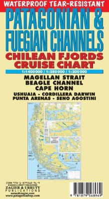
Wegenkaart - landkaart Patagonian & Fuegian Channels - Chilean Fjords Cruise Chart Beagle Channel - Patagonië | Zagier & Urruty

0
Intricate representation of Chilean fjords along the western and far southern edge of southern South America. This clear and uncluttered map shows details of the coastline with minimal topographical information. Historical notes and elevations of coastline illustrated from different bearings. Scale 1:1,400,000 Historical and hydrographical chart. ...

Verkopers met dit product

Webshop
Bezorging
Prijs
DeZwerver.nl logo
DeZwerver.nl
niet bekend
22,95

Anderen bekeken ook

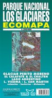
Wegenkaart - landkaart Parque Nacional los Glaciares | Zagier & Urruty
LOS GLACIARES NATIONAL PARK ECOMAP The most incredible Park of Patagonia, including Perito Moreno Glacier and Mount Fitz Roy. Satellite relief, roads, navigation, camping, inns and estancias, etc. El Parque mas espectacular de la Patagonia, donde sobresalen el Glaciar Perito Moreno y el Monte Fitz Roy. Rutas, navegaciones, estancias turisticas, paradores, camping, etc. Spanish / English edition. Southern Patagonia’s main National Park, Los Glaciares, with the world's only advancing glacier. The map uses satellite imagery, enhanced with colours and hill-shading to give a vivid representation of the relief. Many local peaks, glaciers and other geographical features are marked and named. Road network includes unpaved roads and dirt tracks, with locations of petrol stations and intermediate driving distances. Ferry connections on the region’s numerous lakes are also indicated. Symbols highlight accommodation and restaurant facilites. Latitude and longitude lines are drawn at 15' intervals…
17,95
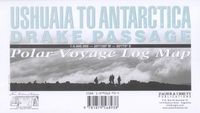
Wegenkaart - landkaart Ushuaia to Antarctica - Drake Passage | Zagier & Urruty
Deze kaart is geschikt voor bootreizen van Ushuaia naar Antarctica. De kaart bevat behalve dieptemeters en stromingen ook de plaatsen van scheepswrakken en andere interessante plekken. The ship voyage from South America to the Antarctic Peninsula is a travel of a lifetime. After two days navigating on a sea of miles deep with the strongest and wildest currents and winds, the traveler arrives to a paradise for people looking for nature, history and adventure. This map is based in the Argentine Hydrographic Survey and the Ushuaia Maritime Museum charts and includes historic sites in the area as well as place for stamps and signatures from the ship and stations crew. A certificate for having crossed the Drake Passage is printed, too. afmeting 65 x 95 cm
17,95
Nieuw
Wegenkaart - landkaart Guyana Suriname & French Guiana | ITMB
Een degelijke wegenkaart met aanduidingen van o.a. nationale parken, vliegveld, benzinepomp, dirt-roads en kleine plattegrond van hoofdstad. Als overzichtskaart goed te gebruiken.   The focus of this map is on Guyana, reflecting the changes coming about as a result of the growing assertiveness of Brasil, which has repaved the highway north from Manaus on the Amazon to the border with Guyana (at Bomfin). The Guyanese are improving the road to Georgetown, shortening travel times for goods in both directions by weeks. This new bridge also enables travelers to pass north and south much more easily. We have also re-done the inset map of Georgetown to bring it up to date. We have also changed the regional map on the reverse side, which used to cover all three Guianas countries, and replaced it by one concentrating on the other two countries. The most significant change we've made is to re-name Surinam to the country's preferred name of Suriname. As we made relatively few changes to the artw…
13,95
Nieuw
Wegenkaart - landkaart Explorer Map North Queensland | Hema Maps
Detailkaart van een deel van Australië. Zeer goed leesbaar, met naast de topografische details veel symbolen waarmee allerhande toeristische zaken worden aangeduid als campsites, nationale parken, attracties, wandelmogelijkheden etc. Covering Australia's beautiful North Queensland. There is alot of town map insets, tourist information, and photographs on the reverse side Touring map of the northern half of Queensland, with enlargements of popular areas, street plans, lists of facilities, etc. The main map extends south to well beyond the Flinders Highway between Townsville and Mount Isa, including Mackay on the coast. The map shows the road network, including minor roads and unsurfaced tracks, plus railways and local airfields/aerodromes. Designated Tourist Routes are highlighted and symbols mark places of interest (many annotated with brief description), historical sites, tourist resorts, youth hostels, etc. Topography is indicated by names of mountain ranges and peaks, as well as by…
17,50
Wegenkaart - landkaart Cordillera Cantabrica - Asturias y provincias limitrofes | Adrados Ediciones
Gedetailleerde wegenkaart an de Cordillera Cantabrica met hoogtelijnen, hoogte verschillen in kleur en schaduw en UTM coördinaten. Met plaatsnamen index! Cordillera Cantabrica on a detailed road map from the Oviedo based Adrados Ediciones, presenting this mountainous region with contours at 100m intervals, altitude coluring, relief shading and UTM coordinates. Since the publishers specialize in detailed hiking maps, including the best coverage of the Picos de Europa, the map includes an exceptionally large number of names of peaks, passes, etc. Symbols highlight best rock and ice climbing areas, huts and refuges, campsites, mountain rescue posts and information centres. Along the coast numerous beaches are named. Road network includes small country roads and tracks. Local railway lines are shown, although not very easy to see on the base map filled with so much information. The map has a 10km UTM grid. Map legend is in Spanish only. On the reverse is a panorama drawing of the area, lo…
14,95
Wegenkaart - landkaart Santa Cruz - Tierra del Fuego - Sur de Chile (Zuid Chili - Vuurland) | Zagier & Urruty
Mooie overzichtskaart / wegenkaart voor het zuiden van Chili en Vuurland. Inclusief een overzicht van de voor fietsers aantrekkelijke Carretera Austral, de eindeloze weg die Vuurland met het echte Chili verbindt. The southern tip of America from Coihaique and Copahue to Cape Horn. Estancias, National Road 40 and Carretera Austral. Patagonian Channels. National Parks and inns. Service charts and distances.
17,95
Wegenkaart - landkaart Antarctic Peninsula - Antarctica | Zagier & Urruty
Kaart van het Antarctisch Schiereiland met tekeningen van de voorkomende Fauna. Dit is het stuk van Antarctica waar vrijwel alle toeristen rondvaren op de cruiseschepen of zeilboten. The North of the Peninsula is the most visited part of Antarctica every summer. Glaciers, inlets and sailing ports, scientific stations, etc. On the back side large maps of the main visited islands and ports. Artistic drawings of birds and mammals.
17,95
Wegenkaart - landkaart South America and Antarctica | National Geographic
• Waterproof • Tear-Resistant • Reference Map   Expertly researched and designed, National Geographic's South America and Antarctica Flags & Facts Map is the authoritative map of South America by which other reference maps are measured. The map side includeds a political map showing countries, cities and other landmarks and a physical map shows the landforms such as mountain ranges and rivers. The Flags & Facts side includes a combined political and physical map of Antarctica.   Clearly defined boundaries, major cities, and physical features Hundreds of place names carefully placed to maintain legibility in heavily populated areas Includes South America and Antarctica and adjacent regions within North America Detailed physical map of South America with mountain ranges, plains, lakes, and rivers Flags and facts with detailed information about cultural and physcial attributes Printed in the U.S.A. on extremely durable, waterproof, and tear-resistant material This Reference Map is printe…
17,50
Wegenkaart - landkaart Kgalagadi - Tourist Map of Kgalagadi Transfrontier Park Botswana | Shell
Zeer bijzondere landkaart van het grensgebied van Botswana en Zuid Afrika. Uitermate handig zijn de GPS coordinaten van de meest belangrijke punten als campings of uitzichtpunten. De kaart is gebaseerd op een luchtfoto, waarbij alle details zijn ingetekend. The map: The map consists of a large map of the entire Park on the front of the map. On the back is enlargements of six maps - the South African side, Mabuasehube, Swart Pan area, Gemsbok Wilderness Trail, Mabuasehube Wilderness Trail and of the Kaa Kalahari Concession. Satellite images were used and the roads were tracked by GPS. There are 168 GPS coordinates on this map. Establishment of a Transfrontier Park: On the 7 th of April 1999 Botswana and South Africa signed a bilateral agreement in which they agreed to manage their adjacent national parks, Gemsbok National Park in Botswana and Kalahari Gemsbok National Park in South Africa, as a single ecological unit – the Kgalagadi Transfrontier Park. It is the first formally declared…
17,50

Klanten-reviews van Wegenkaart - landkaart Patagonian & Fuegian Channels - Chilean Fjords Cruise Chart Beagle Channel - Patagonië | Zagier & Urruty

Er zijn nog geen beoordelingen voor dit productBen jij de eerste die een review plaatst?

Meer over Wegenkaart - landkaart Patagonian & Fuegian Channels - Chilean Fjords Cruise Chart Beagle Channel - Patagonië | Zagier & Urruty

Productomschrijving

Intricate representation of Chilean fjords along the western and far southern edge of southern South America. This clear and uncluttered map shows details of the coastline with minimal topographical information. Historical notes and elevations of coastline illustrated from different bearings. Scale 1:1,400,000

Historical and hydrographical chart. Cruise log for the intrincate coast of the south of South America. Insets of Beagle Channel "Glaciers Avenue", Agostini Fjord, Wulaia Inlet and Romanche Bay


Kaap Hoorn, Straat Magellaan, Punta Arenas, Ushuaia, Cordillera Darwin, Seno Agostini

Uitgevouwen 70 x 100 cm

Verken gerelateerde categorieën

Webshop.nl maakt gebruik van cookies. Ga je verder op onze website, ga dan akkoord met het plaatsen van cookies en de verwerking van deze data door ons en vermelde partners.