webshop.nl
Categorieën
  Sluiten

Meer ITMB

Wegenkaart - landkaart Paraguay & Bolivia South | ITMB

Een degelijke kaart met aanduidingen van o.a. nationale parken, vliegveld, benzinepomp, dirt-roads en kleine plattegrond van hoofdstad. Als overzichtskaart goed te gebruiken. Technically, this is a new title for ITMB, in that it is not merely an updating of a previous edition, but it is still a map of Paraguay, basically, so we count it as an updat...
13,95

Webshops met dit product

Webshop
Bezorging
Prijs

Anderen bekeken ook

Wegenkaart - landkaart Paraguay & Bolivia South | ITMB
Een degelijke kaart met aanduidingen van o.a. nationale parken, vliegveld, benzinepomp, dirt-roads en kleine plattegrond van hoofdstad. Als overzichtskaart goed te gebruiken. Technically, this is a new title for ITMB, in that it is not merely an updating of a previous edition, but it is still a map of Paraguay, basically, so we count it as an updated edition with part of Bolivia included. Expanding the area of coverage benefits visitors combining Paraguay and Bolivia into one trip. The first side covers Bolivia from La Paz south to the Paraguayan border, with inset maps of Potosi and Santa Cruz. The second side concentrates on Paraguay itself, with inset maps of Asuncion, the Asuncion region, and northern Paraguay. Small bits of bordering countries also are included. Road connections within Paraguay have been shown to good advantage. Both countries, being land-locked, are somewhat isolated, making travel to them something more adventuresome than visits to neighbouring countries. Howeve…
13,95
Wegenkaart - landkaart Korea, North & South | ITMB
Een degelijke kaart met aanduidingen van o.a. nationale parken, vliegveld, benzinepomp en dirt-roads. Als overzichtskaart goed te gebruiken. Met Noord Korea, schaal 1:830.000, aan een kant en op de andere zijde Zuid Korea, schaal 1:550.000. This is a brand new title for ITMB, combining North and South Korea into one double-sided map focusing on the entire Korean Peninsula rather than its political components. The peninsula is undergoing a lot of change at the moment, and no one knows the ultimate outcome. North Korea seems interested in opening itself somewhat to South Koreans, and even if steps to date seem like baby ones, tensions between north and south seem cordial at the moment. For the time being, this map replaces our separate map of North Korea, as changing conditions makes it too risky for us to re-do our North Korea title until its future path is clearer. However, although this map also shows South Korea in good detail, we will continue marketing our Seoul and South Korea map…
13,95
Wegenkaart - landkaart 3407 Adventure Map Uruguay - Paraguay | Nationa
Wegenkaart van Uruguay en Paraguay  met vermelding van veel bezienswaardigheden, nationale parken en attrakties. Watervast en scheurvast. Juist door deze vermeldingen onderscheidt de kaart zich van andere wegenkaarten. Let National Geographic's Uruguay and Paraguay Adventure Map guide you as you explore the unique biodiversity, rich history and vibrant culture of these two South American countries. Quickly find your destination with the aid of a user-friendly index of cities and towns. Then plan your route using the mapped road network, complete with distances and designations for major and secondary roads, as well as tracks and unsurfaced roads for those seeking to travel off the beaten path. Other travel network features include airports, airfields, railroads, harbors and border crossings. In addition, hundreds of cultural, historical, ecological and recreational points of interest are pinpointed, such as UNESCO World Heritage Sites, protected areas, beaches, waterfalls, camping, and…
17,50
Wegenkaart - landkaart Tibet | ITMB
Een degelijke kaart met aanduidingen van o.a. nationale parken, vliegveld, benzinepomp, dirt-roads en kleine plattegrond van hoofdstad. Als overzichtskaart goed te gebruiken. Tibet is fascinating and controversial. It has been occupied by China since Chairman Mao send hordes of Chinese troops into the country and annexed it to China, expanding its borders somewhat by over-running parts of northern India a bit later. We do our best to portray the country as it is, without getting overly involved in the political ramifications, which are pretty severe. At the moment, the Chinese authorities seem to be clamping down on tourism, due to simmering unrest. However, the country, or self-governing province of China is a beautiful place and deserves a good map. It is extremely difficult to get updating information on Tibet; we've done our best, but this is very much a work in progress. Printed on ITM plastic for durability, with a new ISBN and cover picture. Legend Includes: Roads by classificat…
13,95
Wegenkaart - landkaart Mauritania & Mali | ITMB
Een degelijke kaart met aanduidingen van o.a. nationale parken, vliegveld, benzinepomp, dirt-roads en kleine plattegrond van hoofdstad. Als overzichtskaart goed te gebruiken. Mali 1:1.900.000 Mauretanië 1:2.200.000 In this edition, we have combined Mauritania with Mali. Although both are interesting countries, the two fit naturally together as a unit, albeit at slightly differing scales. Technically, this should be a 1st edition map, as it is the first time we have combined these two desert countries on to one sheet, but I ll let Robert at the Library of Congress worry about the niceties of bibliographic accuracy as soon as Trump allows him to do the work he loves for a salary. Mauritania was one of the most unusual countries I visited as a young traveller. Of course, I had an advantage, in that I was too young to know that what I was doing was supposed to be impossible. I entered from what was then the Spanish Sahara via a piste (a sandy track with multiple pathways, only some of whic…
13,95
Wegenkaart - landkaart South Pacific Cruising & Samoa | ITMB
Een overzichtskaart van de zuidelijke Stille Oceaan met de cruise routes tussen de verschillende eilanden aangegeven. Op de achterzijde een overzichtskaart van Samoa This is a new venture for ITMB. Cruising is a rapidly-growing segment of the travel industry, experiencing double-digit growth rates annually. Obviously, this is a thriving market. In conjunction with several cruise ship lines, we have prepared a map of the South Pacific Ocean, which extends southwards from Hawai'i to the southern tip of New Zealand and eastwards from central Australia/Papua New Guinea to the Pitcairn Islands. Thus, it does not include the popular South East Asia and China coast routes. We think this has to change at a time when 25,000,000 people are travelling by cruise ships. At the same time, we must keep coverage area relevant for those end users of the artwork. Even at 1:12M, most of the area covered is water, with island countries such as Fiji, Tonga, Kiribati, Tahiti, and the Cook Islands being visi…
13,95
Wegenkaart - landkaart Mauritania & Mali | ITMB
Een degelijke kaart met aanduidingen van o.a. nationale parken, vliegveld, benzinepomp, dirt-roads en kleine plattegrond van hoofdstad. Als overzichtskaart goed te gebruiken. Mali 1:1.900.000 Mauretanië 1:2.200.000 In this edition, we have combined Mauritania with Mali. Although both are interesting countries, the two fit naturally together as a unit, albeit at slightly differing scales. Technically, this should be a 1st edition map, as it is the first time we have combined these two desert countries on to one sheet, but I ll let Robert at the Library of Congress worry about the niceties of bibliographic accuracy as soon as Trump allows him to do the work he loves for a salary. Mauritania was one of the most unusual countries I visited as a young traveller. Of course, I had an advantage, in that I was too young to know that what I was doing was supposed to be impossible. I entered from what was then the Spanish Sahara via a piste (a sandy track with multiple pathways, only some of whic…
13,95

Klanten-reviews van Wegenkaart - landkaart Paraguay & Bolivia South | ITMB

Er zijn nog geen beoordelingen voor dit productBen jij de eerste die een review plaatst?

Meer over Wegenkaart - landkaart Paraguay & Bolivia South | ITMB

Productomschrijving

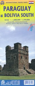
Een degelijke kaart met aanduidingen van o.a. nationale parken, vliegveld, benzinepomp, dirt-roads en kleine plattegrond van hoofdstad. Als overzichtskaart goed te gebruiken. Technically, this is a new title for ITMB, in that it is not merely an updating of a previous edition, but it is still a map of Paraguay, basically, so we count it as an updated edition with part of Bolivia included. Expanding the area of coverage benefits visitors combining Paraguay and Bolivia into one trip. The first side covers Bolivia from La Paz south to the Paraguayan border, with inset maps of Potosi and Santa Cruz. The second side concentrates on Paraguay itself, with inset maps of Asuncion, the Asuncion region, and northern Paraguay. Small bits of bordering countries also are included. Road connections within Paraguay have been shown to good advantage. Both countries, being land-locked, are somewhat isolated, making travel to them something more adventuresome than visits to neighbouring countries. However, both are hospitable, safe, and tourist-friendly. Legend Includes: International Border, Provinvial Border, National Park, Highway, Major road, Main Road, Railway, International Airport, Domestic Airport, Sand, salt Lake, Large River, Waterfall, Point of Interest, Mining, ect.

Productspecificaties

Artikelnummer(s)
Brand
ITMB
Webshop.nl maakt gebruik van cookies. Ga je verder op onze website, ga dan akkoord met het plaatsen van cookies en de verwerking van deze data door ons en vermelde partners.