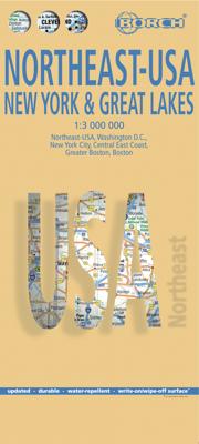
Wegenkaart - landkaart 5 Noordoost USA - Northeast USA | Borch

0
Mooie geplasticieerde kaart van het Noordoosten van de USA. Deze kaart biedt een goed overzicht van het land met detailkaarten.   Our soft-laminated folded map of Northeast-USA - New York & Great Lakes shows: Northeast USA 1:3 000 000, Greater Boston 1:1 000 000, Central East Coast 1:1 000 000, Boston 1: 14 000, New York City 1:20 000, Washington ...

Verkopers met dit product

Verkoper
Bezorging
Prijs
DeZwerver.nl logo
DeZwerver.nl
2,95
11,50

Anderen bekeken ook

Wegenkaart - landkaart 5 Noordoost USA - Northeast USA | Borch
Mooie geplasticieerde kaart van het Noordoosten van de USA. Deze kaart biedt een goed overzicht van het land met detailkaarten.   Our soft-laminated folded map of Northeast-USA - New York & Great Lakes shows: Northeast USA 1:3 000 000, Greater Boston 1:1 000 000, Central East Coast 1:1 000 000, Boston 1: 14 000, New York City 1:20 000, Washington DC 1:15 000, USA administrative & time zones. Borch maps are easy to fold, durable and water-repellent with a wipeable surface. Borch Maps show hotels, museums, monuments, markets, public transport, top sights and points of interest, useful statistics, conversion charts for temperatures, weights and measurements, climate charts showing temperatures, sunshine hours, precipitation and humidity, overview maps, time zones, and much more...   From Philadelphia's Independence Park to Boston's Freedom Trail, New York's Federal Hall to Washington's Capitol Hill, from the Potomac to the "honeymooners' paradise" of Niagara Falls, New England and the mi…
11,50
Wegenkaart - landkaart 4 New England & Atlantic Noordoost USA | Hallwag
Uitstekende wegenkaart waarbij de Europese kleurstelling de kaart zeer prettig leesbaar maken i.v.m. met Amerikaanse kaartenmakers. Deze kaart is eenzijdig bedrukt. Op de kaart is informatie te vinden waar allerlei voorzieningen te vinden zijn (d.m.v. symbolen), zoals campings, picknickplaatsen, informatiecentra, luchthavens enz. Bij de kaart zit een apart boekje met een aantal kleine stadsplattegronden, informatie over Nationale Parken en overige informatie voor toeristen. Met Maine, New Hampshire, Vermont, New York, Massachusetts, Rhode Island, Connecticut, Pennsylvania, New Jersey and large Maryland and Delaware. These new, region by region "USA Road Guides", on a scale of 1 : 1 mio, provide up-to-date, detailed road maps with lots of tourist information. Transit and city maps, as well as detailed maps of national parks, are included in the map layout. The map package also includes a mileage chart with travelling times between major cities, and a brochure with an index of places, t…
14,95
Wegenkaart - landkaart 3012 Adventure Map India Northeast - Noordoost | National Geographic
Wegenkaart van Noordoost India met vermelding van veel bezienswaardigheden, nationale parken en attrakties. Watervast en scheurvast.   National Geographic's India Northeast Adventure Map is designed to meet the unique needs of adventure travelers with its durability and detailed, accurate information. The map includes the locations of thousands of cities and towns with a user-friendly index, as well as a clearly marked road network complete with distances and designations for highways, major routes and secondary roads.   The India Northeast Adventure Map differs from a traditional road map for it includes hundreds of points of interest that highlight the diverse and unique destinations found in this region. The map features UNESCO World Heritage sites, archaeological sites, wildlife sanctuaries, Hindu and Buddhist temples, forts, ruins, caves and other points of interest, making it an invaluable resource to travelers hoping to experience all the history and culture this part of India …
17,50
Wegenkaart - landkaart 3127 United States Northeast | National Geographic
Mooie kaart van de bekende kaartenmaker National Geographic. Veel details door kleurgebruik. De wegen zijn met kleuren verdeeld in drukke en minder drukke, de wegnummers zijn goed terug te vinden. De kaart onderscheidt zich van andere series door de hoeveelheid topografische details als counties, plaatsnamen en waterwegen en het bevat een register waarin het eenvoudig zoeken is. Daarnaast is de kaart gedrukt op scheur- en watervast papier. The United States Northeast Adventure Map will guide you through the states of the Mid Atlantic region (Virginia, West Virginia, Maryland, Delaware and Pennsylvania, New York and New Jersey) and New England (Connecticut, Rhode Island, Massachusetts, Vermont, New Hampshire, and Maine). Each of these states is rich in history and nature and has its own distinct character, from the dramatic rocky shoreline of Maine's Acadia National Park and the beaches and dunes of Cape Cod Massachusetts, through the Adirondack Mountains of New York, the White and Gre…
17,50
Wegenkaart - landkaart 6 Zuidoost USA - Southeast USA | Borch
Mooie geplasticieerde kaart van het Zuidoosten van de USA. Deze kaart biedt een goed overzicht van het land met detailkaarten. Our soft-laminated map of the southeast of the USA - USA 6 includes: The South & Florida 1:3 000 000, Central Florida 1:1 350 000, Atlanta & Region 1:1 000 000, Atlanta Downtown 1:15 000, Miami & Florida Keys 1:1 000 000, Miami Downtown 1:20 000, South Miami Beach 1:20 000, New Orleans & Region 1:1 000 000, New Orleans French Quarter 1:13 000, USA administrative & time zones, interesting statistics, conversion chart for temperatures, weights and measures, climate chart with temperatures, sunshine hours, precipitation and humidity and much more.   From Washington D.C. along the Atlantic coast to Florida and west to Louisiana and Arkansas, this is original plantation country, which has long since "gone with the wind". Yet traces of the charming Old South can still be found in the historic cities of Alexandria, Williamsburg, Charleston, and Savannah, and along th…
11,50
Wegenkaart - landkaart 2 Southwest-USA - Zuidwest USA | Borch
Mooie geplasticieerde kaart van het Zuidwesten van de USA. Deze kaart biedt een goed overzicht van het land met detailkaarten.   Our soft-laminated folded map of the American Southwest shows: American Southwest 1:3 000 000, Phoenix 1:20 000, San Francisco Bay Area 1:400 000, San Francisco 1:15 000, Greater Los Angeles 1:250 000, San Diego 1:125 000, San Diego Downtown 1:25 000, Las Vegas - The Strip 1:22 000, Grand Canyon National Park 1:250 000, USA administrative & time zones. Borch Maps show hotels, museums, monuments, markets, public transport, top sights and points of interest, useful statistics, conversion charts for temperatures, weights and measurements, climate charts showing temperatures, sunshine hours, precipitation and humidity, overview maps, time zones, and much more...   From the panoramas of San Francisco and the buzz of megametropolis Los Angeles to the charm of San Diego on the Mexican border - the Californian coast boasts sun, beautiful beaches, stunning scenery an…
11,50
Wegenkaart - landkaart USA Interstate | Borch
Mooie, overzichtelijke wegenkaart van de snelwegen in Amerika. Handig als je grote afstanden in het land moet afleggen.   Our soft-laminated folded map of the USA in the 9th edition shows: USA West, USA East, Hawaiian Islands, Puerto Rico each 1:4 000 000, Alaska 1:8 000 000, USA administrative & time zones. Borch Maps are easy to fold, durable and water-repellent with a wipeable surface. Borch Maps show hotels, museums, monuments, markets, public transport, top sights and points of interest, useful statistics, conversion charts for temperatures, weights and measurements, climate charts showing temperatures, sunshine hours, precipitation and humidity, overview maps, time zones, and much more...   "Get your motor running, head out on the highway"! The Interstate highway system (officially the "Dwight D. Eisenhower National System of Interstate and Defense Highways") authorized by the Federal Aid Highway Act of 1956 and supported by former US President Eisenhower who had been impressed …
11,50
Wegenkaart - landkaart 583 Northeastern USA, Eastern Canada | Michelin
Wegenkaart van het noordoostelijke gedeelte van de USA (Kansas City - Fargo - Boston - Washington DC) en zuidoost Canada (Québec - Montréal - Ottawa - Winnipeg - Regina). Zie uitsnede op de voorkant van de kaart. Primary & secondary road networks are clearly marked out with indications of the number of lanes, intermediate distances and various possible road obstacles or things you should know including steep hills, height limits, toll barriers, prohibited roads and roads subject to restrictions.   The map also includes small insets with street plans of the regions major towns, showing road names, one way streets and various places of interest (tourist sights, hospitals, parking, railway stations, etc.). Scenic routes on the map are marked out in green and an extensive index of place names is included.   The map also features:   Administrative boundaries Railways, Airports and Ferry Services Important sights such as castles, ruins, and churches Driving Times and Distance Cha…
12,95
Wegenkaart - landkaart 1 Noordwest USA - Northwest USA | Borch
Mooie geplasticieerde kaart van het Noordwesten van de USA. Deze kaart biedt een goed overzicht van het land met detailkaarten. Our soft-laminated map of USA Northwest - USA 1 includes: Pacific Northwest 1:3 000 000, San Francisco 1:15 000, San Francisco Bay Area 1:400 000, San Francisco & Region 1:1 000 000, Seattle 1:13 000 and Greater Seattle 1:350 000, Seattle & Region 1:1 000 000,  Portland 1:20 000, Denver & Region 1:1 000 000, Salt Lake City & Region 1:1 000 000, Yellowstone National Park 1:1 000 000, USA administrative & time zones, interesting statistics, conversion chart for temperatures, weights and measures, climate chart with temperatures, sunshine hours, precipitation and humidity and much more.   The beautiful landscape of Oregon and Washington includes rugged coastline, mountain ranges, lakes, rivers, rich farmland and burgeoning wine country, as well as the magnificent cities of Portland and Seattle with their bustling cosmopolitan flair. While Seattle is renowned as …
11,50

Klanten-reviews van Wegenkaart - landkaart 5 Noordoost USA - Northeast USA | Borch

Er zijn nog geen beoordelingen voor dit productBen jij de eerste die een review plaatst?

Meer over Wegenkaart - landkaart 5 Noordoost USA - Northeast USA | Borch

Productomschrijving

Mooie geplasticieerde kaart van het Noordoosten van de USA. Deze kaart biedt een goed overzicht van het land met detailkaarten.   Our soft-laminated folded map of Northeast-USA - New York & Great Lakes shows: Northeast USA 1:3 000 000, Greater Boston 1:1 000 000, Central East Coast 1:1 000 000, Boston 1: 14 000, New York City 1:20 000, Washington DC 1:15 000, USA administrative & time zones. Borch maps are easy to fold, durable and water-repellent with a wipeable surface. Borch Maps show hotels, museums, monuments, markets, public transport, top sights and points of interest, useful statistics, conversion charts for temperatures, weights and measurements, climate charts showing temperatures, sunshine hours, precipitation and humidity, overview maps, time zones, and much more...   From Philadelphia's Independence Park to Boston's Freedom Trail, New York's Federal Hall to Washington's Capitol Hill, from the Potomac to the "honeymooners' paradise" of Niagara Falls, New England and the mid-Atlantic States are brimming with history and tantalising beauty. Those who want to escape the frenetic pace of New York and Boston will be delighted by New England's old charm: the timeless beauty of "America's Rhine" (Hudson River Valley north of New York); the wildlife refuges of Long Island; the unique flavour of Cape Cod; the historic cities of Worcester and Providence. Washington D.C., the nation's magnificent capital, provides opportunity for fascinating excursions into the beautiful history-laden hinterland, including Manassas and Fredericksburg - former battlefields of the Civil War, Pennsylvania Dutch Country, the intriguing Appalachian ridges where the first Irish and German settlers established their roots and the enchanting scenery around Virginia's Tidewater region.  

Productinformatie

    Verken gerelateerde categorieën

    Webshop.nl maakt gebruik van cookies. Ga je verder op onze website, ga dan akkoord met het plaatsen van cookies en de verwerking van deze data door ons en vermelde partners.