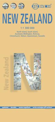
Wegenkaart - landkaart Nieuw - Zeeland | Borch

0
Mooie geplasticieerde kaart van Nieuw - Zeeland. Deze kaart biedt een goed overzicht van het land met detailkaarten.   Our soft-laminated map of New Zealand includes: North Island 1:1 300 000, South Island 1:1 300 000, Auckland 1:20 000, Christchurch 1:20 000, Dunedin 1:15 000,  Nelson 1:15 000, Rotorua 1:15 000, Queenstown 1:15 000, Wellington 1:...

Verkopers met dit product

Verkoper
Bezorging
Prijs
DeZwerver.nl logo
DeZwerver.nl
2,95
11,50

Anderen bekeken ook

Wegenkaart - landkaart Nieuw - Zeeland | Borch
Mooie geplasticieerde kaart van Nieuw - Zeeland. Deze kaart biedt een goed overzicht van het land met detailkaarten.   Our soft-laminated map of New Zealand includes: North Island 1:1 300 000, South Island 1:1 300 000, Auckland 1:20 000, Christchurch 1:20 000, Dunedin 1:15 000,  Nelson 1:15 000, Rotorua 1:15 000, Queenstown 1:15 000, Wellington 1:20 000, New Zealand administrative & time zones, interesting statistics, conversion chart for temperatures, weights and measures, climate chart with temperatures, sunshine hours, precipitation and humidity and much more.   "4 million inhabitants and 60 million sheep" does not do justice to the charm and natural diversity of this beautiful country. Lush meadows and fertile soils are only some of the natural resources with which New Zealand is endowed, the real natural wealth of this island state in the middle of the South Pacific lies in its incredibly diverse landscape: snow-covered mountains, dense forests, lush green lowlands, crystal-clear…
11,50
Wegenkaart - landkaart Nieuw Zeeland - New Zealand | Freytag & Berndt
Gedetailleerde, tweezijdige landkaart van Nieuw Zeeland, prima geschikt voor planning en rondtrekken. De berijdbare wegen zijn goed weergeven, zowel de hoofdwegen als provinciale en lokale wegen; wegnummers worden vermeld. Afstanden tussen plaatsen zijn in kilometers op de kaart ingetekend, daarnaast worden ook op belangrijke plekken benzinepompen gemarkeerd. In het kaartbeeld wordt door middel van schaduw het reliëf weergegeven en soms enkele punten in het landschap met de daadwerkelijke hoogte. Provinciegrenzen zijn goed terug te vinden, nationale parken en reservaten ook. Met allerhande symbolen worden toeristische bezienswaardigheden weergegeven als monumenten, historisch belangrijke plekken, uitzichtpunten, hotels en campings. Ook luchthavens, treinverbindingen en havens vindt u er op!   Explore New Zealand with this Freytag & Berndt map. The best way to plan your trip, prepare your itinerary, and to travel independently in this country. As with all Freytag & Berndt maps the car…
14,95
Wegenkaart - landkaart 3500 Adventure Map New Zealand - Nieuw Zeeland | National Geographic
Wegenkaart van Nieuw Zeeland met vermelding van veel bezienswaardigheden, nationale parken en attrakties. Watervast en scheurvast. Juist door deze vermeldingen onderscheidt de kaart zich van andere wegenkaarten. National Geographic's New Zealand Adventure Map is designed to meet the unique needs of adventure travelers—detailed, durable, and accurate. The map includes the locations of thousands of major cities and towns with an index for easily locating them, plus a clearly marked road network complete with distances and designations for major highways, toll roads, limited access highways and more.   What sets National Geographic Adventure Maps apart from traditional road maps are the hundreds of points-of-interest that highlight the diverse, unique, and exotic destinations within New Zealand including National Parks and Preserves, World Heritage Sites, Archeological sites, ski areas, beaches, golf courses, camping areas, waterfalls, natural points of interest and important travel aids…
17,50
Wegenkaart - landkaart Auckland & North Island - Nieuw Zeeland | ITMB
Scale 1:12,500/1:950,000, This new ITMB map should really be called Auckland, Wellington, Christchurch and the North Island of New Zealand, but that’s too long a title. However, in addition to Auckland, the cities of Wellington and Christchurch are included on one side of the map (NZ urban areas don’t tend to be huge). The other side is a very detailed map of North Island, the main island of the country. This map will be perfect for both finding one’s way around Auckland’s waterfront and for exploring the highways and byways, communing with woolies; printed double-sided on paper
13,95
Wegenkaart - landkaart 790 New Zealand - Nieuw Zeeland | Michelin
Zoals je van Michelin mag verwachten is deze kaart zeer overzichtelijk en heeft een duidelijk helder kaartbeeld. De kaart geeft uitgebreide toeristische informatie weer. De perfecte overzichtskaart!   This New Zealand map from Michelin is part of their red national map series. These are perfect for route planning as well as getting around by car once you're there. They clearly mark out major roads and also show many of the more important minor roads.    The map's simple folding design with durable paper cover, allows it to be read like a book and easily folded back together. Road numbers and intermediate distances are clearly displayed with the more scenic routes highlighted in green.   The map also features:   Political boundaries Regional and National Parks Important sights (points of interest, historic sites, etc.) Driving Times and Distances Road Safety Information A legend in multiple languages (Dutch, English, French, German and Spanish) Michelin New Zealand Map 790 is a new add…
12,95
Wegenkaart - landkaart South Island (Zuider Eiland - Nieuw Zeeland) | Hema Maps
Uitstekende overzichtskaart met index, afstandstabel, nationale parken en toeristische informatie. Gedetailleerder dan de gehele Nieuw - Zeeland kaart. This map is easy to read and feature clear, easy to read cartography, reliefshading, National Parks, Points of Interest, Tourist Routes, Distance Grid and Walking Tracks. Printed one sided and complete with index these are an ideal planning tool as well as an ideal travel companion. This regional map of the South Island of New Zealand (NZ) is at a scale of 1:1,000,000 and shows points of interests, tourist routes, walking tracks and national parks for touring the island. On the reverse side are handy city maps of Christchurch, Picton, Nelson, Queenstown, Dunedin, Blenheim and Invercargill, and suburb maps of Christchurch and Dunedin. It also includes detailed maps of Fiordland, Kahurangi, Arthur’s Pass and Aoraki National Parks along with a distance grid.   PRODUCT FEATURES   • National parks • Topographic maps • Tourist routes • Dista…
17,50
Wegenkaart - landkaart Nieuw Zeeland - New Zealand - Aotearoa | Hema Maps
Folded, indexed road and tourist map of New Zealand, showing all major and many minor roads, cities, and towns in detail. Map shows highways, road numbers, distance chart, railways, scenic routes, places of particular interest, places of scenic beauty, national parks, and political boundaries. Reverse of map shows city insets of Auckland, Wellington, Christchurch, Rotorua, Dunedin, and Queenstown. Legend is in English. Heldere goed leesbare kaart van de kaartenmaker van Nieuw Zeeland: de HEMA maps.
17,50
Wegenkaart - landkaart Brazilië - Brazil | Borch
Mooie geplasticieerde kaart van het Brazilië. Deze kaart biedt een goed overzicht van het land met detailkaarten. Our soft-laminated map of Brazil in the 5th edition includes: Brazil 1:4 000 000, Fernando de Noronha Island 1:4 000 000, Brazil Amazon 1:8 000 000, Brasíiia 1:60 000, Manaus 1:15 000, Rio de Janeiro Center 1:15 000, Rio de Janeiro 1:175 000, Sao Paulo 1:20 000, Fortaleza 1:15 000, Natal 1:22 000, Recife 1:15 000, Salvador 1:14 000, Curitiba, Florianópolis, Porto Alegre each 1: 15 000, Brazil administrative & time zones; interesting statistics: conversion chart for temperatures, weights and measures; climate chart with temperatures, sunshine hours, precipitation and humidity; hotels, museums, markets and much more.   The Federative Republic of Brazil is the fifth largest country in the world, the largest and most populous country and largest economy in South America and the seventh largest economy in the world. Bordered by the Atlantic Ocean to the east, the remaining bord…
11,50
Wegenkaart - landkaart Dominicaanse Republiek | Borch
Mooie geplasticieerde kaart van de Dominicaanse Republiek. Deze kaart biedt een goed overzicht van het land met detailkaarten.   Our soft-laminated map of the Dominican Republic includes: Dominican Republic 1:600 000, Puerto Plata & Region 1:250 000, Puerto Plata 1:20 000, Santiago 1:17 500, Santo Domingo & Region 1:250 000, Santo Domingo 1:22 500, Colonial Santo Domingo 1:10 000, Punta Cana & Region 1:185 000, Dominican Republic administrative / time zones; interesting statistics: conversion chart for temperatures, weights and measures; climate chart with temperatures, sunshine hours, precipitation and humidity; table of distances; hotels, museums, markets, public transport and much more.   Christopher Columbus discovered the island of Hispaniola on December 5th 1492 and founded "La Navidad", said to be the first European settlement in the New World. He became viceroy of Hispaniola and settled in the place where today's capital, Santo Domingo, is situated. During the following centur…
11,50
Wegenkaart - landkaart Chile - Chili | Borch
Mooie geplasticieerde kaart van Chili. Deze kaart biedt een goed overzicht van het land met detailkaarten. Our soft-laminated folded map of Chile shows: Northern Chile, Central Chile, Southern Chile & Patagonia 1:2 000 000, Torres del Paine National Park 1:240 000, Robinson Crusoe Island 1:200 000, Easter Island (Rapa Nui) 1:160 000, Punta Arenas, Antofagasta, Iquique 1:15 000, Valparaiso 1:10 000, Arica 1:16 000, La Serena 1:13 000, Vina del Mar 1:22 000, Santiago 1:20 000 and Chile administrative & time zones. Borch Maps are easy to fold, durable and water-repellent with a wipeable surface. Borch Maps show hotels, museums, monuments, markets, public transport, top sights and points of interest, useful statistics, conversion charts for temperatures, weights and measurements, climate charts showing temperatures, sunshine hours, precipitation and humidity, overview maps, time zones, and much more...   The Republic of Chile is a long and narrow coastal strip on the western side of the S…
11,50

Klanten-reviews van Wegenkaart - landkaart Nieuw - Zeeland | Borch

Er zijn nog geen beoordelingen voor dit productBen jij de eerste die een review plaatst?

Meer over Wegenkaart - landkaart Nieuw - Zeeland | Borch

Productomschrijving

Mooie geplasticieerde kaart van Nieuw - Zeeland. Deze kaart biedt een goed overzicht van het land met detailkaarten.   Our soft-laminated map of New Zealand includes: North Island 1:1 300 000, South Island 1:1 300 000, Auckland 1:20 000, Christchurch 1:20 000, Dunedin 1:15 000,  Nelson 1:15 000, Rotorua 1:15 000, Queenstown 1:15 000, Wellington 1:20 000, New Zealand administrative & time zones, interesting statistics, conversion chart for temperatures, weights and measures, climate chart with temperatures, sunshine hours, precipitation and humidity and much more.   "4 million inhabitants and 60 million sheep" does not do justice to the charm and natural diversity of this beautiful country. Lush meadows and fertile soils are only some of the natural resources with which New Zealand is endowed, the real natural wealth of this island state in the middle of the South Pacific lies in its incredibly diverse landscape: snow-covered mountains, dense forests, lush green lowlands, crystal-clear rivers and lakes, endless beaches and majestic fjords, even rainforests and volcanoes. New Zealanders know what their homeland has to offer: the skiing season lasts all year in the magnificent alps of South Island; climbers and hikers come here to test their strength against nature; anglers hunt for swordfish in the coastal waters or fish for trout in Lake Taupo; there are beautiful camp sites to be found everywhere. New Zealand is paradise for nature and sport lovers, and you can always be sure of a warm welcome from the friendly locals.  

Productinformatie

    Verken gerelateerde categorieën

    Webshop.nl maakt gebruik van cookies. Ga je verder op onze website, ga dan akkoord met het plaatsen van cookies en de verwerking van deze data door ons en vermelde partners.