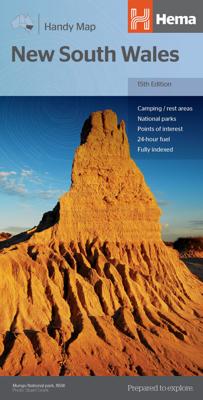
Wegenkaart - landkaart New South Wales handy map | Hema Maps

0
Goede, tweezijdige overzichtelijke, leesbare kaart van de hele provincie. Nationale Parken zijn er goed op te vinden en de afstanden worden weergegeven.  New South Wales Map in a series of indexed touring road maps of Australia’s states from Hema, with each state available either on a single-sided map with additional information on the reverse, or...

Alle aanbiedingen van dit product

Verkoper
Bezorging
Prijs
DeZwerver.nl logo
DeZwerver.nl
2,95
14,95

Anderen bekeken ook

Wegenkaart - landkaart New South Wales handy map | Hema Maps
Goede, tweezijdige overzichtelijke, leesbare kaart van de hele provincie. Nationale Parken zijn er goed op te vinden en de afstanden worden weergegeven.  New South Wales Map in a series of indexed touring road maps of Australia’s states from Hema, with each state available either on a single-sided map with additional information on the reverse, or as double-sided map in a more convenient smaller format. The map presents the road network from main highways, shown with their names, to minor roads and 4WD tracks, indicating unsealed routes and rough tracks. Driving distances are marked on many smaller local roads. Railway lines and local airports or airstrips are included. Symbols highlight roadside rest areas, 24h fuels supplies, as well as campsites and caravan parks, places of interest, etc. Colouring indicates national parks and other protected areas including marine parks, Aboriginal lands and restricted entry zones. The maps have a latitude/longitude grid at intervals varying from …
14,95
Wegenkaart - landkaart New South Wales | Hema Maps
Erg mooie, handige en uitgebreide kaart van New South Wales. Great for travel planning, Hema's New South Wales state map clearly shows highways, minor and secondary roads, national and state routes and fully-indexed cities, towns and localities. Detailed road distances are also shown.   The flipside of the map features loads of insets covering various bits and pieces throughout New South Wales including a Sydney CBD and throughroads map, a Canberra CBD map, a Sydney region map, a map of the Blue Mountains National Park and a map of the area betwwen Katoomba and Wentworth Falls. There's also a list of information centres giving their address, phone number and website.   The map features:   Camping areas Rest areas 24 hour fuel locations Outback fuel stops Caravan parks National parks A full index Points of interest A distance grid
17,95
Wegenkaart - landkaart North East New South Wales | Hema Maps
Detailkaart van een deel van Australië. Zeer goed leesbaar, met naast de topografische details veel symbolen waarmee allerhande toeristische zaken worden aangeduid als campsites, nationale parken, attracties, wandelmogelijkheden etc. The map covers the east coast from just south of Coffs Harbour north to Brisbane and west to Inverell. Extensive tourist information and photographs are provided on the area, every point of interest highlighted, and a matrix details all of the facilities available in the National Parks. Detailed road map of the coastal area from Coffs Harbour to Brisbane, extending inland across the Great Dividing Range to beyond the New England Highway. Topography is shown by relief shading with names of mountain ranges and selected peaks. National parks, reserves, and state forests highlighted. Symbols indicate campsites and caravan parks, 24hour fuel supplies, information centres, places of interest, etc. Numerous wineries are highlighted, particularly around Stanthorp…
17,50
Wegenkaart - landkaart South Australia state handy map | Hema Maps
Duidelijke, handzame kaart van South Australia.  Great for using in the car, Hema's South Australia Handy Map clearly shows highways, minor and secondary roads, national and state routes and fully-indexed cities, towns and localities. Detailed road distances are also shown. The map splits the state in two, with half on one side of the map and half on the other. This results in a much smaller piece of paper which is far easier to manage in your car.   The map features:   Camping Areas Rest Areas 24 Hour Fuel Outback Fuel Caravan Parks National Parks Fully Indexed Points of Interest Distance Grid
14,95
Wegenkaart - landkaart Western Australia - West Australië state handy map | Hema Maps
Duidelijke, handzame kaart van Western Australia. Zeer goed leesbaar, met naast de topografische details veel symbolen waarmee allerhande toeristische zaken worden aangeduid als campsites, nationale parken, attracties, wandelmogelijkheden etc. Great for using in the car, Hema's Western Australia Handy Map clearly shows highways, minor and secondary roads, national and state routes and fully-indexed cities, towns and localities. Detailed road distances are also shown.    The map splits the state in two, with half on one side of the map and half on the other. This results in a much smaller piece of paper which is far easier to manage in your car.   The map features:   Camping Areas Rest Areas 24 Hour Fuel Outback Fuel Caravan Parks National Parks Fully Indexed Points of Interest Distance Grid   All of the state handy maps are double-sided and come in an easy-to-fold format.
14,95
Wegenkaart - landkaart South Australia state map | Hema Maps
Mooie, duidelijke en uitgebreide kaart van South Australia. Great for travel planning, Hema's South Australia state map clearly shows highways, minor and secondary roads, national and state routes and fully-indexed cities, towns and localities. Detailed road distances are also shown.   The flipside of the map features loads of insets covering various bits and pieces throughout South Australia including an Adelaide CBD and throughroads map, an Adelaide region map, a map of the Barossa Valley and the Flinders Ranges National Park. There's also a list of information centres giving their address, phone number and website.   The map features:   Camping areas Rest areas 24 hour fuel locations Outback fuel stops Caravan parks National parks A full index Points of interest A distance grid
17,95
Wegenkaart - landkaart Victoria handy map - tweezijdig | Hema Maps
Duidelijke, handzame wegenkaart van de staat Victoria. Inclusief index. Great for using in the car, Hema's Victoria Handy Map clearly shows highways, minor and secondary roads, national and state routes and fully-indexed cities, towns and localities. Detailed road distances are also shown.   The map splits the state in two, with half on one side of the map and half on the other. This results in a much smaller piece of paper which is far easier to manage in your car.   The map features:   Camping Areas Rest Areas 24 Hour Fuel Outback Fuel Caravan Parks National Parks Fully Indexed Points of Interest Distance Grid   All of the state handy maps are double-sided and come in an easy-to-fold format.
14,95
Wegenkaart - landkaart Queensland handy map - tweezijdig | Hema Maps
Duidelijke, handzame kaart van Queensland. Inclusief index.   Great for using in the car, Hema's Queensland Handy Map clearly shows highways, minor and secondary roads, national and state routes and fully-indexed cities, towns and localities. Detailed road distances are also shown.   The map splits the state in two, with half on one side of the map and half on the other. This results in a much smaller piece of paper which is far easier to manage in your car.   The map features:   Camping Areas Rest Areas 24 Hour Fuel Outback Fuel Caravan Parks National Parks Fully Indexed Points of Interest Distance Grid
14,95
Wegenkaart - landkaart Melbourne and Region Map | Hema Maps
Handige kaart van zowel de stad Melbourne als het omliggende gebied. Description Melbourne & Region The Melbourne and Region map features a primary map of Greater Melbourne (1:115,000) that includes highways, major roads and local streets, as well as 24-hour fuel, parks and caravan parks. On the reverse is a Melbourne CBD map with accommodation, shopping and other places of interest pinpointed, along with train and tram network maps and a Melbourne Region map. Key Features Highways, major roads and local streets Points of interest Accommodation Travel Information Parks Caravan Parks 24 Hour Fuel Tram lines Railway stations Suburbs Suburbs Index Shopping centres Theatres/Cinemas Sporting venues Tram and Train network maps The cosmopolitan capital of Victoria, Melbourne is a city of distinct districts: each with its own particular appeal. For a different view of the city head to the observation deck at the Eureka Skydeck for 360° views. A cruise along the Yarra River provides yet anothe…
14,95
Wegenkaart - landkaart Queensland state map | Hema Maps
Goede, overzichtelijke, leesbare kaart van de hele provincie. Nationale Parken zijn er goed op te vinden en de afstanden worden weergegeven. Op de achterkant nog deelkaartjes van enkele steden en NP s. A state map of Queensland accompanied by touring information and relevant regional and city maps. Marked on the map are national parks, points of interest, 24-hour fuel as well as camping and rest areas. On the reverse are maps of the Gold Coast, South East Queensland and Tropical North Queensland as well as CBD and throughroads maps of Brisbane. There is a full index included, as well as all national park information. Features: Points of interest 24-hour fuel National parks Camping areas Rest areas Fully indexed Comprehensive road detail Road identification numbering Scenic photographs
17,95

Klanten-reviews van Wegenkaart - landkaart New South Wales handy map | Hema Maps

Er zijn nog geen beoordelingen voor dit productBen jij de eerste die een review plaatst?

Meer over Wegenkaart - landkaart New South Wales handy map | Hema Maps

Productomschrijving

Goede, tweezijdige overzichtelijke, leesbare kaart van de hele provincie. Nationale Parken zijn er goed op te vinden en de afstanden worden weergegeven. 

New South Wales Map in a series of indexed touring road maps of Australia’s states from Hema, with each state available either on a single-sided map with additional information on the reverse, or as double-sided map in a more convenient smaller format.

The map presents the road network from main highways, shown with their names, to minor roads and 4WD tracks, indicating unsealed routes and rough tracks. Driving distances are marked on many smaller local roads. Railway lines and local airports or airstrips are included. Symbols highlight roadside rest areas, 24h fuels supplies, as well as campsites and caravan parks, places of interest, etc. Colouring indicates national parks and other protected areas including marine parks, Aboriginal lands and restricted entry zones. The maps have a latitude/longitude grid at intervals varying from 30’ to 2º. Each title has an index of towns and communities and a distance table.

 

Productinformatie

    Verken gerelateerde categorieën

    Webshop.nl maakt gebruik van cookies. Ga je verder op onze website, ga dan akkoord met het plaatsen van cookies en de verwerking van deze data door ons en vermelde partners.
