Wegenkaart - landkaart Myanmar - Birma | Nelles Verlag

0
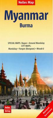
Goede overzichtskaart van Myanmar / Birma. Aan beide kanten bedrukt. Met veel toeristische aanduidingen als culturele bezienswaardigheden en nationale parken. Prima leesbare kaart en bovendien gedrukt op scheur-en watervast papier. Myanmar (Burma) at 1:1,500,000 from Nelles Verlag, with street plans of Yangon (Rangoon) and Mandalay, plus a plan of...

Verkopers met dit product

Verkoper
Bezorging
Prijs
DeZwerver.nl logo
DeZwerver.nl
2,95
11,95

Anderen bekeken ook

Wegenkaart - landkaart 3025 Adventure Map Myanmar - Birma | National Geographic
Mooie, heldere kaart van Myanmar, gedrukt op scheurvast en watervast papier.   National Geographic's Myanmar (Burma) Adventure Map is designed to meet the needs of adventure travelers with its durability and detailed, accurate information. This map includes the locations of cities and towns with a user-friendly index, a clearly marked road network complete with distances and designations for roads/highways, plus secondary routes for those seeking to explore off the beaten path. Adventure Maps differ from a traditional road map because of the specialty content they include. Each map contains hundreds of diverse and unique recreational, ecological, cultural, and historic destinations — outside of the major tourist hubs. National Geographic Adventure Maps are the perfect companion to a guidebook, yet far easier to pack!   Myanmar is a country with a varied landscape. From the highest peak, Hkakabo Razi, in the Hengduan Shan mountains on the border with China to the lowlands at the mouth …
17,50
Reisgids Myanmar - Burma | Lonely Planet
De perfecte reisgids voor zowel de georganiseerde als de zelfstandige reiziger. Naast een algemene inleiding van het land / streek vol met praktische informatie over hoe je er het beste kunt reizen: slapen, eten, vervoer, excursies ... alles kun je er in vinden. Engelstalig. Lonely Planet. It’s the dawn of a more democratic era in this extraordinary land, where the landscape is scattered with gilded pagodas and the traditional ways of Asia endure. Lonely Planet will get you to the heart of Myanmar, with amazing travel experiences and the best planning advice.   Lonely Planet Myanmar (Burma) is your passport to the most relevant, up-to-date advice on what to see and skip, and what hidden discoveries await you. Be dazzled by Buddhist architecture in Yangon, explore Bagan’s amazing plain of ancient temples, or hike to the floating gardens and markets of Inle Lake; all with your trusted travel companion. Get to the heart of Myanmar and begin your journey now!   Inside Lonely Planet Myanma…
23,95
Reisgids Myanmar (Burma) | Insight Guides
Een rijk geillustreerde reisgids met diepgaande teksten: één van de beste reisgidsen die er bestaan. Eerste deel bestaat uit een beschrijving van de unieke aspecten van de regio, daarna een deel echte reisgids en als afsluiting een deel met praktische informatie. De uitstekende informatie wordt vergezeld van prachtige foto's en heldere kaarten. Niet alleen om mee te nemen, maar ook om vooraf en zelfs achteraf weer in de stemming te komen. With its glittering pagodas, timeless countryside and gracious people, Myanmar (Burma) is an extraordinarily beautiful destination which has been isolated from the rest of the world for decades. Finally, things are changing and tourism is set to explode in the coming years. This new edition of the Insight Guide Myanmar has been comprehensively overhauled to help inspire and inform, and guide you to the best that this little-known country has to offer. Following on from the inspirational Best Of Myanmar section, the country's rich past and cultural h…
22,50
Wegenkaart - landkaart Myanmar - Birma | ITMB
Een degelijke kaart met aanduidingen van o.a. nationale parken, vliegveld, benzinepomp, dirt-roads en kleine plattegrond van hoofdstad. Als overzichtskaart goed te gebruiken. 1:1,350,000 scale 1st Edition, printed double-sided. This was a very difficult country to map, given the political situation in the country. We have been able to create a good base map, but are still suspicious about the condition of secondary roads; map has a good inset of Yangon(Rangoon).
13,95
Wegenkaart - landkaart Cuba | Nelles Verlag
Goede wegenkaart van Cuba. Aan beide kanten bedrukt. Met veel toeristische aanduidingen als nationale parken en culturele bezienswaardigheden. Prima leesbare kaart, nu ook op scheur- en watervast papier Folded road and tourist map of Cuba at 1:775 000 scale. Places of interest, national parks, and beaches are all highlighted and shaded-relief colouring clearly depicts the topography.   The map includes insets showing Varadero at 1:32 000, Camaguey at 1:15 000, Santiago de Cuba at 1:15 000, La Habana (Havana) at 1:15 000, Cienfuegos at 1:23 000 and Trinidad at 1:12 100. The legend is in four languages, including English.   For over 20 years Nelles maps have been renowned throughout the world for their quality, faithfulness to detail and up-to-dateness.    So that streets, ferry links, railway lines, etc are always up to date, Nelles are continuously upgrading their maps - with the help of their international team of correspondents. Roads are provided with an exact kilometerage. Sights …
11,95
Wegenkaart - landkaart Bali & Lombok | Nelles Verlag
Goede wegenkaart van Bali & Lombok. Aan beide kanten bedrukt. Met veel toeristische aanduidingen als nationale parken en culturele bezienswaardigheden. Prima leesbare kaart. One of six maps in a series covering Indonesia, this is a folded road and tourist map of the two Indonesian islands of Bali and Lombok at 1:180 000 scale. Parks, beaches, and places of interest are all highlighted and shaded-relief coloyring clearly depicts the topography.    The map includes insets showing Ubud and it's surroundings at 1:33 000, Denpasar at 1:20 000, Kuta at 1:20 000, Lovina Beach at 1:30 000, Sanur at 1:35 000, Nusa Dua at 1:50 000, the Gili Islands at 1:55 000, Mataram at 1:50 000 and an overview locator map. The legend is in English, French and German.   For over 20 years Nelles maps have been renowned throughout the world for their quality, faithfulness to detail and up-to-dateness.    So that streets, ferry links, railway lines, etc are always up to date, Nelles are continuously upgrading th…
10,95
Wegenkaart - landkaart Kenia - Kenya | Nelles Verlag
Goede kaart van Kenya en de Serengeti. Aan beide kanten bedrukt. Met veel toeristische aanduidingen als nationale parken en culturele bezienswaardigheden. Prima leesbare kaart. Folded road and tourist map of Kenya and the Serengeti at 1:1 100 000 scale. Places of interest, national parks, beaches and camps/lodges are all highlighted and shaded-relief colouring clearly depicts the topography.   The map includes insets showing central Nairobi at 1:20 000, Mombasa at 1:33 000, Lamu Island at 1:550 000 and the Kenya coast at 1:550 000. The legend is in English, French and German.   For over 20 years Nelles maps have been renowned throughout the world for their quality, faithfulness to detail and up-to-dateness.    So that streets, ferry links, railway lines, etc are always up to date, Nelles are continuously upgrading their maps - with the help of their international team of correspondents. Roads are provided with an exact kilometerage. Sights are highlighted extra clearly so that you don…
11,95
Wegenkaart - landkaart Sri Lanka | Nelles Verlag
Goede overzichtskaart met veel symbolen voor bezienswaardigheden als nationale parken en tempels. Tweezijdig met citymaps van Colombo, Anuradhapura, Kandy en Galle. Folded road and tourist map of Sri Lanka at 1:450 000 scale. Places of interest, national parks, and beaches are all highlighted and shaded-relief colouring clearly depicts the topography.    The map includes insets showing Colombo at 1:15 000, Anuradhapura at 1:36 000, Kandy at 1:12 500, Galle Fort at 1:8 000, Hikkaduwa at 1:18 500, Negombo at 1:19 000, Polonnaruwa at 1:26 000 and Unawatuna at 1:11 500. The legend is in English, French and German.   For over 20 years Nelles maps have been renowned throughout the world for their quality, faithfulness to detail and up-to-dateness.    So that streets, ferry links, railway lines, etc are always up to date, Nelles are continuously upgrading their maps - with the help of their international team of correspondents. Roads are provided with an exact kilometerage. Sights are highli…
11,95
Wegenkaart - landkaart 2 India - West | Nelles Verlag
Goede kaart van een deel van India. Aan beide kanten bedrukt. Met veel toeristische aanduidingen als nationale parken en culturele bezienswaardigheden. Prima leesbare kaart. Detailkaart: Mumbai (Bombay) 1 : 300.000 Stadsplattegrond: Delhi 1 : 50.000 one of five maps in a series covering India at 1:1 500 000 scale. Folded road and tourist map of western India, including edge of Pakistan to the west, Chandigarh to the north, Pune to the south and Bhopal and Delhi to the east. Points of interest, national parks, and railways are all highlighted and shaded-relief colouring clearly depicts the topography.  The map includes insets showing central Delhi at 1:50 000 and Mumbai (Bombay) region at 1:300 000. The legend is in English, French and German. The other titles in the series are India East, India North, India North East, and India South. Nelles also produces a map of the whole Indian Subcontinent at a scale of 1:4 500 000.   For over 20 years Nelles maps have been renowned throughout th…
11,95
Reisgids Culture Smart! Myanmar - Burma - Birma - | Kuperard
De Cultuur Bewust!-gids geeft toeristen en zakenlieden belangrijke informatie met betrekking tot de cultuur van alledag in het land van bestemming. Anders dan in de gebruikelijke reisgidsen wordt de lezer in deze reeks bijgespijkerd op het gebied van omgangsvormen, normen en waarden, hoe zich te gedragen en wat verwacht mag worden op zakelijk en sociaal gebied. Het zijn beknopte zakformaatgidsen met interessante wetenswaardigheden over het dagelijks leven. Een must voor iedereen die naar het buitenland gaat voor vakantie, studie of werk. Myanmar, as Burma is now known, is strategically situated between the world's two most populous nations--China and India--and its distinctive ancient culture shares some traditions with both countries. Hidden away from the eyes of the world for half a century by its military rulers' policy of self-isolation, "the Burmese Way to Socialism," with a new democratic parliament and civilian government Myanmar is undergoing important changes as it approaches…
14,95

Klanten-reviews van Wegenkaart - landkaart Myanmar - Birma | Nelles Verlag

Er zijn nog geen beoordelingen voor dit productBen jij de eerste die een review plaatst?

Meer over Wegenkaart - landkaart Myanmar - Birma | Nelles Verlag

Productomschrijving

Goede overzichtskaart van Myanmar / Birma. Aan beide kanten bedrukt. Met veel toeristische aanduidingen als culturele bezienswaardigheden en nationale parken. Prima leesbare kaart en bovendien gedrukt op scheur-en watervast papier.

Myanmar (Burma) at 1:1,500,000 from Nelles Verlag, with street plans of Yangon (Rangoon) and Mandalay, plus a plan of the World Heritage site at Bagan. The map is double-sided, with its smaller size offering a convenient format for use when travelling.    The country is divided north/south, with the panhandle shown as an inset on the southern side. Vivid relief shading with spot heights and names of mountain ranges presents the topography. National parks and/or protected area are indicated.

Bagan 1 : 60.000

Mandalay 1 : 30.000
Yangon (Rangoon) 1 : 60.000

Productinformatie

    Verken gerelateerde categorieën

    Webshop.nl maakt gebruik van cookies. Ga je verder op onze website, ga dan akkoord met het plaatsen van cookies en de verwerking van deze data door ons en vermelde partners.