webshop.nl
Categorieën
  Sluiten

Meer ITMB

Wegenkaart - landkaart Muscat / Oman | ITMB

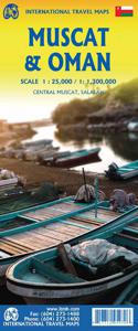
The very name Muscat and Oman entices one! The peninsula at the access point to the Persian/Arabian Gulf sounds very exotic – and it is! This double-sided map focuses on the city and region of Muscat on side one at a detailed scale, noting the Grand Mosque, the Mutrah Souk, and the Royal Opera House as well as showing hotels, shopping areas, and ot...
13,95

Webshops met dit product

Webshop
Bezorging
Prijs

Anderen bekeken ook

Wegenkaart - landkaart Muscat / Oman | ITMB
The very name Muscat and Oman entices one! The peninsula at the access point to the Persian/Arabian Gulf sounds very exotic – and it is! This double-sided map focuses on the city and region of Muscat on side one at a detailed scale, noting the Grand Mosque, the Mutrah Souk, and the Royal Opera House as well as showing hotels, shopping areas, and other sites of touristic interest. Muscat used to be a British protectorate, but is now part of Oman, albeit physically separated from it by a portion of the UAE. The country fills side 2. Oman is portrayed as a north-south alignment, as it is long and not particularly wide, and nicely fills the sheet, with an inset of Salalah, close to the Yemeni border. Connections to nearby Abu Dhabi and Dubai are also shown. Oman is a haven of peaceful co-existence, and tourists are welcome, so this map is designed to encourage visitors
13,95
Wegenkaart - landkaart Oman & Yemen - Jemen | ITMB
Een degelijke kaart met aanduidingen van o.a. nationale parken, vliegveld, benzinepomp, dirt-roads en kleine plattegrond van hoofdstad. Als overzichtskaart goed te gebruiken.    We were in Oman a couple of weeks before year end and can certify that it is a safe and attractive country to visit; completely different from its neighbours. The main city is Muscat, which has an inset map on the country side of the sheet, as well as a map of Salalah, in the far west of the country. The road network of the country is well developed, with several crossings to the UAE. Unfortunately, none are available to Saudi Arabia, and the crossing to Yemen, while open, is not advised, due to on-going fighting. Oman also has two enclaves surrounded by UAE; a small one north of Fujairah, and another at the northern tip of the peninsula, separating the Gulf of Oman from the Persian (or Arabic) Gulf. Oman has a long history and an interesting culture, and is well worth a visit. The other side of the sheet cons…
13,95
Wegenkaart - landkaart Laos | ITMB
Een degelijke kaart van Laos met aanduidingen van o.a. nationale parken, vliegveld, benzinepomp, dirt-roads en kleine plattegronden van Vientiane, Luang Prabang we're very pleased to introduce you to this new, double-sided, map at a great scale, with fantastic detail. To me, the north side is the most interesting, covering the portion of Laos from Vientiane, the capital, to the Chinese border. Detailed inset maps of Vientiane and Louang Prabang, the temple city, are included on this side, as are bits of both Thailand and Vietnam. The south portion fills the other side of the sheet, including a goodly portion of Vietnam, showing all border crossings. Much of Thailand has had to be obscured, unfortunately, to make room for the place names index, but the immediate border areas are shown, including the rail line south from Vientiane. In an interesting departure from previous ITMB maps, the back cover consists of a detailed inset map of Vientiane at 1:16,000 scale, making it easy to use in …
13,95
Wegenkaart - landkaart Canada | ITMB
Een degelijke kaart met aanduidingen van o.a. nationale parken, vliegveld, benzinepomp, dirt-roads en kleine plattegrond van hoofdstad. Well, it’s about time, eh?!? ITMB, after only thirty years on the go, finally gets around to publishing a map of Canada. When we first started mapping, there was a pressing need for good maps of Central and South America, then of Africa, then etc etc and we never found time to concentrate on our own country until fairly recently. This map was prepared by Natural Resources Canada and is, as a result, as accurate a map as one could hope to have. We are very proud of it, and very pleased to be able to use such top-rate cartography. The map covers all of the land mass of Canada, from its southernmost point to the top of Ellesmere Island and from the Atlantic coast to the Pacific. It’s an excellent map, but I’m going to give one proviso. Canada is the second-largest country on the face of the planet and there is no way that a single-sided sheet can portray …
13,95
Wegenkaart - landkaart Abu Dhabi & UAE | ITMB
We are pleased to release this brand new ITMB title. Abu Dhabi is one of the leading Emirates that are rapidly becoming vacation heavens for Europeans who don't want the long flights to Asian destinations. The city is so modern it almost squeaks. The palace is a world-class wonder, the seafront Corniche is a marvelous beach, and the central shopping area offers everything from hamburgers to Gucci bags. Motorways now connect the city state to nearby Dubai and to Oman, with a recently-completed one along the coastline to the Saudi border. The reverse side of the map is an updated edition of the entire United Arab Emirates and most of Oman, with new motorways seemingly everywhere. A large inset map of central Dubai is included, along with a good one of Muscat. We docked at Abu Dhabi's cruise ship terminal during our visit and were impressed by the extent of urbanization of the city. Legend Includes: Roads by classification, Rivers and Lakes, National Park, Airports, Points of Interests, H…
13,95
Wegenkaart - landkaart South Pacific Cruising & Samoa | ITMB
Een overzichtskaart van de zuidelijke Stille Oceaan met de cruise routes tussen de verschillende eilanden aangegeven. Op de achterzijde een overzichtskaart van Samoa This is a new venture for ITMB. Cruising is a rapidly-growing segment of the travel industry, experiencing double-digit growth rates annually. Obviously, this is a thriving market. In conjunction with several cruise ship lines, we have prepared a map of the South Pacific Ocean, which extends southwards from Hawai'i to the southern tip of New Zealand and eastwards from central Australia/Papua New Guinea to the Pitcairn Islands. Thus, it does not include the popular South East Asia and China coast routes. We think this has to change at a time when 25,000,000 people are travelling by cruise ships. At the same time, we must keep coverage area relevant for those end users of the artwork. Even at 1:12M, most of the area covered is water, with island countries such as Fiji, Tonga, Kiribati, Tahiti, and the Cook Islands being visi…
13,95
Wegenkaart - landkaart Queensland | ITMB
Een degelijke wegenkaart van Queensland met aanduidingen van o.a. nationale parken, vliegveld, benzinepomp, dirt-roads en kleine plattegrond van hoofdstad. Als overzichtskaart goed te gebruiken. We complete our series of regional maps covering Australia with this map of Queensland, which nicely fills a double-sided sheet with only small portions of adjoining states showing. The map also includes a large inset map of central Brisbane. At this scale, the road/rail network of this part of Australia becomes very clear. The first side concentrates on the northern portion of the state, and the other side, the more densely-developed southern half. The map includes a listing of the state’s top attractions, and notes al major touristic attractions. Although gas/petrol stations are commonly found, we have included some gas symbols in remoter parts of Queensland to encourage drivers to venture into roads less travelled. All states and territories of Australia are now available from ITMB as separa…
13,95

Klanten-reviews van Wegenkaart - landkaart Muscat / Oman | ITMB

Er zijn nog geen beoordelingen voor dit productBen jij de eerste die een review plaatst?

Meer over Wegenkaart - landkaart Muscat / Oman | ITMB

Productomschrijving

The very name Muscat and Oman entices one! The peninsula at the access point to the Persian/Arabian Gulf sounds very exotic – and it is! This double-sided map focuses on the city and region of Muscat on side one at a detailed scale, noting the Grand Mosque, the Mutrah Souk, and the Royal Opera House as well as showing hotels, shopping areas, and other sites of touristic interest. Muscat used to be a British protectorate, but is now part of Oman, albeit physically separated from it by a portion of the UAE. The country fills side 2. Oman is portrayed as a north-south alignment, as it is long and not particularly wide, and nicely fills the sheet, with an inset of Salalah, close to the Yemeni border. Connections to nearby Abu Dhabi and Dubai are also shown. Oman is a haven of peaceful co-existence, and tourists are welcome, so this map is designed to encourage visitors

Productspecificaties

Artikelnummer(s)
Brand
ITMB
Webshop.nl maakt gebruik van cookies. Ga je verder op onze website, ga dan akkoord met het plaatsen van cookies en de verwerking van deze data door ons en vermelde partners.