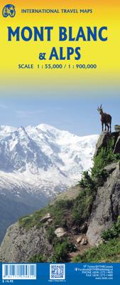
Wegenkaart - landkaart Mont Blanc & Alpen | ITMB

0
As far as mountains go, Mont Blanc in France and Italy, forming the border between the two countries, with Switzerland nearby, is the best known and most attractive mountain in the Alps. The peak itself is far too challenging for most climbers to attempt, but the region is dotted with ski lifts, hiking trails in the lower regions, and fascinating ...

Verkopers met dit product

Verkoper
Bezorging
Prijs
DeZwerver.nl logo
DeZwerver.nl
2,95
14,95

Anderen bekeken ook

Wegenkaart - landkaart Liechtenstein & Oostenrijk West | ITMB
Europe is dotted with mini-states that exist solely for historic reasons but are fiercely independent. Liechtenstein, surrounded by Switzerland on its west and south and Austria on its other borders, is such a state. It is larger and more diverse than many imagine and is quite a popular ski resort region. Side 1 is a detailed map of the principality, framed on the west by the Rhine River and a bit of Switzerland and on the east by Austria. Most development occurs in the Rhine Valley in a north-south direction, dominated by the capital city of Vaduz. There are five access points from Switzerland across the Rhine, one from the south, and two from Austria in the north. The ski haven of Malbun is prominently shown, and the scale of the map is detailed enough to name every major street. This also enabled us the opportunity to include schools, shopping areas, post offices, and churches, as well as a wide range of eating establishments. Walking/hiking trails have also been included. This is …
14,95
Wandelgids Trekking in the Silvretta and Ratikon Alps | Cicerone
Aanbevolen wandelkaarten bij deze gids: Schaal 1:60.000 Wandelkaart 14 Unterengadin | Kümmerly & Frey Wandelkaart 13 Davos - Arosa | Kümmerly & Frey Of schaal 1:25.000 Wandelkaart 26 Alpenvereinskarte Silvrettagruppe This guide describes three treks, between 5 and 8 days, in the Silvretta and Rätikon Alps starting near Klosters, and 12 half-day hut-to-hut routes. These contrasting ranges form a line on the borders of Switzerland, Austria and Liechtenstein. The Tour of the Silvretta, the Prättigauer Höhenweg and the Rätikon Höhenweg. Straddling the borders of Austria, Switzerland and Liechtenstein, the limestone Rätikon Alps reach into the snow-bound and glacier-hung Silvretta Alps to provide a richly diverse series of landscapes. The Tour of the Silvretta, the Prättigauer Höhenweg and the Rätikon Höhenweg, all within easy reach of Klosters, have been devised to help trekkers explore the best of the region. Given sifficient time they can also be combined to create a continuous 2-week t…
25,95
Reisgids Abruzzo (Abruzzen) | Bradt Travel Guides
Voor vele landen net zo goed, zo niet beter dan de Planet. Beduidend soberder uitgevoerd, maar ook met veel informatie voor backpackers en met veel kaartmateriaal. Een aanrader! This new, fourth edition of Bradt’s Italy: Abruzzo remains the only standalone English-language guide to this beautiful, increasingly favoured part of Italy. Abruzzo offers the best of undiscovered Italy, from pristine beaches to mountain glaciers, with charming medieval villages clinging to the hillsides in between. This edition has been thoroughly updated to cover all recent developments, explaining in detail its appeal for active tourism, including wildlife-watching, trekking, skiing and horse-riding, plus family holidays.   Abruzzo offers one of Italy’s most beautiful coastlines, which lie near the country’s tallest mountain ranges outside the Alps. Little wonder that Abruzzo is Italy’s second most popular skiing centre bar the Alps and that it offers some the country’s finest hiking and wildlife-watching …
26,50
Wegenkaart - landkaart Tahiti - French Polynesia | ITMB
Anyone who has visited Tahiti retains fond memories of a wonderful Polynesian paradise. This map shows the major islands of French Polynesia as a series of large insets on Side 1. An overall inset map showing the many islands is also shown, but for showing detail, one must expand the individual islands. The largest one is the volcanic Tahiti Nui, with the capital city of Pape’ete (or Papeete in English), for which a detailed inset map is included. Most visitors stay in the vicinity of Papeete, along the coast. We show several popular resorts. There is a good circular road around the island’s shoreline, but no roads in the interior. The island is joined to another, called Tahiti Iti, or Little Tahiti, and roads extend partway around this less-developed part of the combined island. Most of the other islands are rarely visited, although they have resorts, beaches, and a lifestyle of their own. Names like Huahine, Riatea, Tahaa, and Maiao may not be as familiar as they should be, but all …
14,95
Wegenkaart - landkaart Sahara | ITMB
Een degelijke overzichtskaart met aanduidingen van o.a. nationale parken, vliegveld, benzinepomp, dirt-roads.Waterproof. Double-sided, waterproof and tear-resistant map, extending east to just beyond 25°(the border of Libya and Egypt) , and roughly to 15° degrees (Bamako and Niamey) on its western half, and slightly further south on the other side (beyond Kano and Ndjamena). Elevation colouring indicates the topography, with landscape feature such as calderas, scarps and cliffs, lava fields, dunes, serir, marches, seasonal rivers, and salt pans. Oases and numerous wells/waterholes are also marked, most of them with names. International boundaries are shown with, where appropriate, border crossings. Road network includes rough tracks, and indicates location of petrol stations. Railways within the coastal areas of the covered countries are marked, and the map also shows small local airfields. A range of symbols indicate selected accommodation including rest houses and campsites, hospita…
13,95
Wegenkaart - landkaart Bahrain & Qatar | ITMB
Een degelijke kaart met aanduidingen van o.a. nationale parken, vliegveld, benzinepomp, dirt-roads en kleine plattegrond van hoofdstad. Als overzichtskaart goed te gebruiken.  Schaal: - Bahrein 1:115.000 - Qatar 1:300.000 The northern portion of the United Arab Emirates consists of a small peninsula (Qatar) and an island (Bahrain). Although these countries are not geographically significant in relation to their neighbours, they are enormously wealthy, thanks to oil, and have aspirations of grandeur. Qatar hosted the FIFA World Cup of soccer in November 2022. This is significant. Qatar, as a destination country, is now 'on the map'. Its capital, Doha, is quite well developed, with three Metro subway lines, motorways, and a sophisticated city centre dominated by superb high-rise architecture. Just to the west, the island of Bahrain is just as wealthy, and just as likely to have ornate architecture, luxurious shopping arcades, and an extravagant lifestyle. Its capital, Manama, is growing…
13,95
Wegenkaart - landkaart Cambodia & Mekong Delta | ITMB
Een degelijke kaart met aanduidingen van o.a. nationale parken, vliegveld, benzinepomp, dirt-roads en kleine plattegronden van de hoofdsteden.   Tourism to Cambodia is growing so quickly that we felt it necessary to bring back the country as its own map, instead of being combined with Laos. However, the entire country fits very nicely on one side of a map sheet, so we have combined it with neighboring Vietnam's Mekong Delta map. There are two treasures in Cambodia: the Angkor Wat complex of temples near Siem Riep, and the Capital of Phnom Penh. Cambodia became extremely destabilized by the Vietnam War in the 1960s, leading to a rebellion that placed the murderous Khmer Rouge in charge. This led to massive atrocities and de-populated all towns, killing millions. Siem Riep is a thriving touristic city, and UNESCO manages the Angkor complex very well. The capital has mostly recovered, but still retains the sleepy colonial atmosphere of the French era. River boats ply the Mekong River and…
13,95
Reisinspiratieboek - Reisboek Book of the Alps | Marmota Maps
The Book of the Alps  the great illustrated book about the Alps.290 pages with over 1000 illustrations, graphics, and maps on geography, sports, history, culture, climate, environment and much more. Understand the Alps like never before.Created in cooperation with the Alpine clubs of Germany, Austria, and South Tyrol. CONTENTS The Book of the Alps has 46 chapters in seven subject areas: Geography   Flora and Fauna   Climate and Environment    Alpinism   Mountain Sports   Society and Economy   Arts and Culture   GEOGRAPHY Geological Formation Ice Age Mountains Valleys Mountain Passes Lakes and Rivers Glaciers The Alps are unique. How did they form and evolve? How do glaciers, passes, valleys, lakes, and rivers shape the landscape? Answers to these and many more questions can be found in the geography chapter.   FLORA AND FAUNA Biodiversity Plants Forests Animals National Parks The Alpine environment is fascinating. Alpine flowers such as the edelweiss and Alpine anima…
44,95
Wandelgids Bernese Oberland & Valais | Sunflower books
Wandelgids: vele dagtochten worden degelijk beschreven met openbaar vervoer informatie, goede routebeschrijvingen en kaartmateriaal. Tevens enkele autotochten. Deze gids staat goed bekend!  This new guide – in Sunflower’s new, wider format – covers the most popular destinations in western Switzerland, countryside blessed with a most dramatic and spectacular landscape. Mountains, glaciers, lakes, rivers, gorges, and waterfalls are plentiful natural elements into which cultural influences blend. Although a car is the best way to explore much of the Oberland and Valais, Switzerland boasts the world’s best public transport system. You can see a vast majority of its mountain landscapes by public transport. There are many suggested train tours in the guide. But where trains don’t go, buses will – even to remote valleys and hamlets.   Switzerland is a hiker’s paradise (you would expect nothing less of a country which has an article in its constitution regulating the responsibilities of those…
20,95
Wegenkaart - landkaart Dolomiti - Dolomieten - Lago di Garda - Venezia | Tabacco Editrice
Dolomites – Lake Garda - Venice region of north-eastern Italy on a road map at 1:200,000 from Tabacco with excellent presentation of the topography derived from the publishers’ highly regarded and popular hiking maps, plus on the reverse a panorama drawing of the mountains. Coverage extends from the Austrian border southwards to the A4 motorway including the whole of Lake Garda, Verona, Padua and Venice, plus east to Lienz/Pordenone.   The map provides a very clear picture of the region’s landscape through graphic relief for its exposed rocky areas, plus relief shading and contours at 100m intervals, and has plenty of names of individual groups, peaks, valleys, etc. Additional colouring indicates woodlands and boundaries of national parks and other protected areas are marked. Minor roads are drawn without generalizing their course, showing the twists and turns across the mountainous terrain. Driving distances are marked on main and many connecting routes. Railway lines are shown with …
9,95

Klanten-reviews van Wegenkaart - landkaart Mont Blanc & Alpen | ITMB

Er zijn nog geen beoordelingen voor dit productBen jij de eerste die een review plaatst?

Meer over Wegenkaart - landkaart Mont Blanc & Alpen | ITMB

Productomschrijving

As far as mountains go, Mont Blanc in France and Italy, forming the border between the two countries, with Switzerland nearby, is the best known and most attractive mountain in the Alps. The peak itself is far too challenging for most climbers to attempt, but the region is dotted with ski lifts, hiking trails in the lower regions, and fascinating scenic villages. Mont Blanc tops out at 4,807.81 metres and is protected by Monte Bianco National Park in Italy. There is a long tunnel underneath the mountain joining France (near Chamonix) and Italy (near Courmayeur) and a beautiful highway along its western side (the D1506) and in Italy along its south side (SS26). There is also a Grande Route long-distance hiking trail that surrounds the mountain. We show it in its entirety, including numerous overnight stopping areas, either in towns or in mountain refuges. Naturally, skiing is a huge draw, and we include several ski lifts, all rail lines in the region, including the fabulous cog line from Chamonix to the Grotte de Glace. The Grande Route trail also passes through Switzerland, and we note numerous places to stay in Champex-Lac and La Fouly. The map also includes La Thuile, in Italy, with its many hotels, and touches the nearby French resort town of Sixt-Fer-a-Cheval, a name that should entice anyone to go and visit. The second side of the map is just as interesting, covering the Alps from Geneva to Zagreb, providing drivers with comprehensive coverage of all highways and secondary routes. Rail routes are also emphasized. Given its grandiose scale, touristic points are limited to the most important, but numerous camping sites are noted, as well as all towns and border crossings, notably with Switzerland. The map has two covers, one favouring Mont Blanc and one oriented to the Alps themselves, providing opportunities to market this interesting title to two markets.  

Productinformatie

    Verken gerelateerde categorieën

    Webshop.nl maakt gebruik van cookies. Ga je verder op onze website, ga dan akkoord met het plaatsen van cookies en de verwerking van deze data door ons en vermelde partners.