Meer ITMB
Meer ITMB in Reisgidsen & talen boeken

Wegenkaart - landkaart Mongolia - Mongolië | ITMB

0
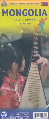
Een degelijke kaart met aanduidingen van o.a. nationale parken, vliegveld, benzinepomp, dirt-roads en kleine plattegrond van hoofdstad. Als overzichtskaart goed te gebruiken. Thinking back, it seems hard to believe that we have sold through five editions of Mongolia maps. Of course, it is a popular travel destination, and reliable information is no...

Verkopers met dit product

Verkoper
Bezorging
Prijs
DeZwerver.nl logo
DeZwerver.nl
niet bekend
13,95

Anderen bekeken ook

Wegenkaart - landkaart Mongolia - Mongolië | Gizi Map
Tweetalige kaart A folded road map covering covering all of Mongolia, as well as parts of the surrounding countries. Subtle relief shading and spot heights show the topography. Road detail is good including many minor tracks, intermediate road distances are also shown in kilometres on the bigger roads.   Various places of interest are marked out including airports, monuments, ruins, administrative boundaries and national parks All place names are written in roman script, with bigger towns also in cyrillic. The extensive index included on the back of the map gives all place names in roman and cyrillic script.    An inset showing a street map of the capital, Ulaan Baatar, at 1:30 000 is also included.   The legend is in 7 languages including English.
15,95
Wegenkaart - landkaart British Columbia | ITMB
Wegenkaart van alleen British Columbia. Calgary in het oosten staat er nog net op. Met campsites, register en nationale parken. This is our eight printing of our most popular provincial map for Canada. As with previous versions, we have updated road changes and new bridges. BC is not changing particularly quickly at the moment, due to the economic recession, but tens of thousands of people continue to migrate to the province each year, and its population is expected to double over the next twenty years. Thanks to its enormous size, huge tracts of land have been set aside for wilderness preservation, and yet the province boasts a road and rail network that would be the envy of smaller countries. The scenery tends to be described in superlative terms. Since I live her, I'll avoid the cliches, and content myself by saying that not only is this map superlative, we've reduced the retail price, so it is much more affordable both in America and overseas. Printed on paper, double-sided; inset…
13,95
Wegenkaart - landkaart Western Australia | ITMB
The State of Western Australia occupies the western third of the continental country of Australia. The main city is Perth, in the southwest portion, and this is the part of the State with the best land and the most people. Much of the interior is arid desert-like grassland with shallow lakes that often dry out. The road network in the south is generally paved highways and secondary roads, with one road and one rail line heading east to SZ and the rest of the country. Roads in the north tend to be dirt, with the exception of the highway going towards Darwin in NT. There are no roads through the Great Sandy Desert, but the Canning Stock Route crosses the eastern fringe, going north-south. One needs an expensive permit to drive this hazardous track. Most of the attractions of the State are to be found fairly close to the coastline. Most of the larger urban areas tend to have been named after British places, such as Albany, Exmouth, and Port Hedland, but many names have been adopted from …
13,95
Wegenkaart - landkaart USA Verenigde Staten | ITMB
Een degelijke kaart met aanduidingen van o.a. nationale parken, vliegveld, benzinepomp, dirt-roads en kleine plattegrond van hoofdstad. Als overzichtskaart goed te gebruiken. United States of America (USA) Travel Reference Map has been mapped before, but the USA is a huge country, extremely developed, and almost impossible to show on a map without over-simplification. Most commercial maps use small sheets of paper and print single-sided, making it impossible to show this vast country to advantage. Well, Lan’s been hard at work developing a ‘proper’ traveller’s aid to navigating around the USA, and here it is. We printed it on an exceptionally large sheet of paper, 39” tall by 54” wide (our normal printing size is 27”x39”). To do this, we merged our four existing databases into one, then split them so that the west side is on one side and the east side on the other. What results is a very large sheet, but a map at a VERY good scale. We were able to fit in 6,765 urban areas, all the Int…
13,95
Wegenkaart - landkaart Tasmania & Victoria | ITMB
Een degelijke wegenkaart van Tasmanie & Victoria, schaal 1:1.800.000, en Tasmanië, schaal 1:800.000 met aanduidingen van o.a. nationale parken, vliegveld, benzinepomp, dirt-roads. Als overzichtskaart goed te gebruiken. The island of Tasmania is Australia’s smallest state, but is packed with touristic delights. Hobart is the capital and a charming Victorian city in the south of the island. Much of the west coast is a large nature preserve with limited access and most development is close to the northern shore, centred on Devonport and its ferry connections with Melbourne, in Victoria State. Tasmania also administers several offshore islands, such as King, Flinders, and Bruny. We have included a Top Attractions listing for the reader to enjoy. The other side of the sheet is the Australian mainland state of Victoria, best known as the home of Melbourne and the beautiful coastal highway to Adelaide. A basic inset map of Melbourne is included, but the focus of the map is on the recreationa…
13,95
Wegenkaart - landkaart Mongolei - Mongolië | Reise Know-How Verlag
Tweetalige kaart (Engels en Duits). Door ingetekende lengte- en breedtegraden is het gebruik van GPS mogelijk. Met hoogtelijnen en uitgebreid wegennetwerk: daarnaast worden ook de afstanden tussen belangrijke plaatsen duidelijk leesbaar weergegeven. Het kleurgebruik is zodanig dat je een goede indruk krijgt van hoogteverschillen en soorten landschap. Natuurlijk staan de toeristische bezienswaardigheden duidelijk vermeld.   Gedrukt op water- en scheurvast papier! Polyart is een synthetisch product vrij van giftige stoffen dus duurzaam. Het papier gaat echt lang mee.   Topography is indicated by altitude colouring with numerous spot heights and names of mountain ranges and passes. Salt lakes, swamps, seasonal rivers and glacier are also shown. Detailed presentation of the road network includes minor roads and tracks and railways are also shown.   Internal administrative units are presented with their boundaries and names. National parks and other protected areas are highlighted. A wide …
11,50
Wegenkaart - landkaart San Francisco - Northern California (Californië) | ITMB
San Francisco met schaal 1: 12.500   San Fran is one of my favourite cities; almost as nice as Vancouver. Names such as Chinatown, Nob Hill, the Tenderloin, and Cow Hollow evoke memories of a city that has long moved past its early reputation as a port feeding the goldfields around Sutter's Run, but it is still a clean and sophisticated city to visit. I personally like the old restored trolleys trundling down Market Street, and the restaurants in the Sunset district. This edition adds great value to our map in two ways: first, we have added an extremely detailed and attractive map of all of northern California to the reverse, to help visitors enjoy the Napa Valley, Sacramento, and the Redwood Sequoia trees, and secondly, the map has been printed on plastic paper for durability and attractiveness.   Legend Includes:   Roads by classification, Provincial Boundaries,State Highways, Main Roads, Secondary and other Roads, Capital, Cities, Nature sights, Airports, Point of Interests, Museum…
13,95
Wegenkaart - landkaart Californië - California | ITMB
  Waterproof wegenkaart van Californië op schaal 1:1m met inzetjes van Hollywood, LA, Santa Monica en San Francisco. Natuurkundige overzichtskaart met veel plaatsen en wegen, spoorlijnen en rivieren, hoogten, lengte- en breedtegraden   The map includes inset maps of Hollywood, Los Angeles, Santa Monica, and San Francisco.   Legend Includes: Roads by classification, Provincial Boundaries,State Highways, Main Roads, Secondary and other Roads, State Capital, Cities, Nature sights, Airports, Point of Interests, Museums, Hot Springs, Gas Stations, National Reserves, Hotels, Lodges,Golf courses and much more
13,95
Wegenkaart - landkaart Scandinavia - Scandinavië | ITMB
Een degelijke wegenkaart met aanduidingen van o.a. nationale parken, vliegveld. Als overzichtskaart goed te gebruiken. This is a new title for ITMB, providing detailed coverage of almost all of what most of us consider to be the Scandinavian countries. Only the southernmost portions of Denmark had to be left off. The map is double-sided, with Denmark and most of Norway and Sweden on one side and their balances and Finland on the reverse side. The road network, particularly the motorways and A-type roads shown up very well. Secondary roads show well and also are easy to see. Rail lines are present as well as ferry routes, of which there are many. The area of Scandinavia is so large in the European context that little attention has been paid to the region. When mapping a large area such as this is, it is difficult to show every detail. We have done our best and included all world heritage sites, major churches, castles, some campsites, and as many touristic attractions as could be fitte…
13,95

Klanten-reviews van Wegenkaart - landkaart Mongolia - Mongolië | ITMB

Er zijn nog geen beoordelingen voor dit productBen jij de eerste die een review plaatst?

Meer over Wegenkaart - landkaart Mongolia - Mongolië | ITMB

Productomschrijving

Een degelijke kaart met aanduidingen van o.a. nationale parken, vliegveld, benzinepomp, dirt-roads en kleine plattegrond van hoofdstad. Als overzichtskaart goed te gebruiken. Thinking back, it seems hard to believe that we have sold through five editions of Mongolia maps. Of course, it is a popular travel destination, and reliable information is now much more readily available than was the case when we first started mapping this vast and largely undeveloped desert country. I think it is fair to say that the main road network is pretty much fixed in position, but secondary roads tend to be tracks that follow diverse paths towards obscure destinations. Regardless, it is a lovely country to visit, with lots to see and friendly people. We've updated the Ulaanbaatar capital city inset map, noting the train ticketing office (which isn't in the train station), several museums and various temples.   Legend Includes: Roads by classification, Provincial Boundaries, Highways, Main Roads, Secondary and other Roads, Capital, Cities, Nature sights, Airports, Point of Interests, Museums, Hot Springs, Glaciers, Gas Stations, Medical Facility, National Reserve, Hotels, Border Crossing, Mine, Mountain Peakas and much more

Productinformatie

    Productspecificaties

    Artikelnummer(s)
    Brand
    ITMB

    Verken gerelateerde categorieën

    Webshop.nl maakt gebruik van cookies. Ga je verder op onze website, ga dan akkoord met het plaatsen van cookies en de verwerking van deze data door ons en vermelde partners.