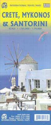
Wegenkaart - landkaart Kreta, Mykonos & Santorini / Oostelijke Middellandse zee cruising | ITMB

0

Verkopers met dit product

Verkoper
Bezorging
Prijs
DeZwerver.nl logo
DeZwerver.nl
2,95
12,95

Anderen bekeken ook

Wegenkaart - landkaart Mediterranean Cruises - Cruises Middellandse Zee | Freytag & Berndt
Landkaart van het hele Mediterrane gebied van Zuid-Europa, Midden-Oosten en Noord-Afrika (Portugal, Spanje, zuid Frankrijk, Italië, Malta, Slovenië, Kroatië, Montenegro, Albanië, Bosnië, Griekenland, Turkije, Cyprus, Syrië, Libanon, Israël, Egypte, Libië, Tunesië, Algerije en Marokko) op schaal 1:2.000.000 met natuurkundig kaartbeeld veel plaatsen, natuurgebieden, wegen en spoorwegen aangegeven, en verder zijn duidelijk aangegeven de havensteden met autoveerboten, afstanden en verder inzetkaartje van de veerverbindingen in het westelijk deel van de Zwarte Zee De kaart is handig voor het plannen van auto of treinvakanties met een oversteek over het water of als overzichtskaart voor cruises in het Middellandse zeegebied A double-sided, full-color map of the Mediterranean, including the Iberian Peninsula and Black Sea, North Africa and the Levant, at a scale of 1:2,000,000. Two Sides  
14,95
Wegenkaart - landkaart 8 Kreta - Oostelijk deel | Road Editions
On a scale of 1:100,000, which is the most detailed scale available for a map of Crete, you will find the most detailed road network ever to have appeared on a map of Crete, a precise geophysical background (in cooperation with the Hellenic Military Geographic Service), all the island's hydrography and the greatest wealth of information of interest to the traveller: All the archaeological sites, monasteries, country chapels and castles. Nature lovers and hikers will be overjoyed by the mapping of E4 trail and all its side trails, the mountain refuges, the mountain peaks, the canyons and the gorges.
10,95
Wegenkaart - landkaart - Fietskaart D66 Top D100 Pyrenees Orientales - Oostelijke Pyreneeen | IGN - Institut Géographique National
Een nieuwe serie die de oude 1:100.000 serie van IGN vervangt: de indeling van deze kaartenserie is gebaseerd op de Franse departementen.   Ideale kaart voor fietsen en autotochten vanuit een vaste plaats als een camping of huisje. Zelfs de kleinste wegen staan ingetekend en geven met symbolen toeristische informatie. De belangrijkste doorgaande GR's staan ook ingetekend. Nieuw zijn de VELO Voie Vertes, lokale fietspaden die meestal gemarkeerd zijn; ook deze zijn ingetekend. Het omvat fietsroutes in samenwerking met de vereniging AF3V – VéloRoutes en Voies Vertes.   Ook is deze kaart voor wandelaars nog behoorlijk goed bruikbaar: veel details, hoogtelijnen en allerlei andere landschapskenmerken. Berghutten en gites d'etappes zijn weergeven, helaas staan er dan wel weer geen campings op.   Van de uitgever: In de cartografie is een grote hoeveelheid toeristische informatie zeer nauwkeurig weergegeven: parken en natuurreservaten, monumenten, kastelen, musea, grotten, uitkijkpunten, toevl…
10,95
Wegenkaart - landkaart Guam - West Pacific Cruising | ITMB
Een degelijke kaart met aanduidingen van o.a. nationale parken, vliegveld, benzinepomp, dirt-roads. Als overzichtskaart goed te gebruiken. Certainly, this is the only map of Guam by any major cartographic publishing house. Here are some details: Guam is a north-south island considerably north of New Guinea, and forms part of the American-held group of islands known as the Northern Marianas. Its capital is Hagatna, and the main town is called Tamuning. The island has a well-developed international airport in the middle portion of the island, with a large US military airbase in the northeast corner. The vast majority of the island is touristic, and well worth a visit. The island was "discovered" by Ferdinand Magellan in 1521, and Hagatna is the oldest "European" city in the Pacific, dating from 1686. The town of Inarajan retains a decidedly Spanish appearance to this day. Other attractions include Tumon Beach and its many resorts, the Piti Underwater Observatory, and the famous Cocos Is…
13,95

Klanten-reviews van Wegenkaart - landkaart Kreta, Mykonos & Santorini / Oostelijke Middellandse zee cruising | ITMB

Er zijn nog geen beoordelingen voor dit productBen jij de eerste die een review plaatst?

Meer over Wegenkaart - landkaart Kreta, Mykonos & Santorini / Oostelijke Middellandse zee cruising | ITMB

Productinformatie

    Verken gerelateerde categorieën

    Webshop.nl maakt gebruik van cookies. Ga je verder op onze website, ga dan akkoord met het plaatsen van cookies en de verwerking van deze data door ons en vermelde partners.