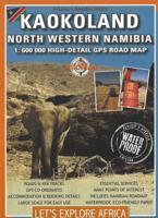
Wegenkaart - landkaart Kaokoland and northern Damaraland - Namibië | Infomap

0
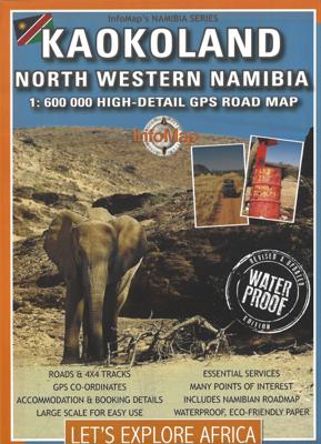
Goede betrouwbare kaart van het noordwesten van Namibië: Damaraland en Kaokoland. Met GPS coordinaten. Engels Colour folding Map, 52x73 cm, scale 1:620.000. The first scale road map of this area to be produced with GPS co-ordinates. 100 GPS Co-ordinates of major intersections, refuelling points and accommodation information. Map range 11°45’ to 15...

Verkopers met dit product

Verkoper
Bezorging
Prijs
DeZwerver.nl logo
DeZwerver.nl
2,95
15,95

Anderen bekeken ook

Wegenkaart - landkaart Kaokoland and northern Damaraland - Namibië | Infomap
Goede betrouwbare kaart van het noordwesten van Namibië: Damaraland en Kaokoland. Met GPS coordinaten. Engels Colour folding Map, 52x73 cm, scale 1:620.000. The first scale road map of this area to be produced with GPS co-ordinates. 100 GPS Co-ordinates of major intersections, refuelling points and accommodation information. Map range 11°45’ to 15°00’ East and 17° to 20°00’ South. Detailed road map Kaokoland / Kaokoveld (Namibia) includes GPS co-ordinates of major intersections, refuelling points and accomodation information.   This map covers North-Western Namibia on the one side and BUSHMANLAND and CAPRIVI in North-Eastern Namibia on the reverse side. This map is very much recommended for travelers to these regions as an addition to our bigger scaled Namibia map. Here you get a nice amplified look at the regions with loads of GPS coordinates, accommodation and petrol points. Furthermore we included extensive route and travel ideas and general information on Kaokoland. Sold in a plas…
15,95
Wegenkaart - landkaart Namibia - Namibië | Tracks4Africa
Uitstekende dubbelzijdige wegenkaart van Namibië, gemaakt door gerenommeerde kaartenmaker Track4Africa in Afrika. Met afstanden en reistijden tussen steden en op alle wegen vermeld. GPS via hun website te downloaden. De kaart wordt door vrijwel elke reisorganisatie geadviseerd als je met een eigen auto in Namibië rond gaat rijden. The Tracks4Africa Namibia paper map is designed to be used in conjunction with the T4A GPS Map of Namibia. It is the largest available Namibia map at 1:1,000,000 scale, offering you the perfect trip planning tool for your next Namibian holiday.  This T4A paper map series are probably the first comprehensive country maps in the world, offering travel time information for the entire road network, be it on tar, gravel or sand!    Key features:    Large 1:1,000,000 scale  Travel times and distances included on the map  What you see on the paper map is exactly what you get on T4A GPS Maps  Comprehensive set of roads and tracks in nature reserves  Detailed in…
27,50
Wegenkaart - landkaart Richtersveld National Park and Northern Namaqualand | Infomap
Wegenkaart met toeristische informatie en geschikt voor gebruik met GPS   The original InfoMap! Now in its 8th edition this map remains as popular as ever. For those who don’t know, the Richtersveld National Park is a 160 000 hectare national park found on the banks of the Orange River in South Africa’s Northern Cape. It is the only mountain desert park in Southern Africa and is one of the few national parks in which you are not confined to your car. Dry, arid with a feeling of isolation, life in the park is influenced by the mist created by the cold Atlantic Ocean. Known to the local Nama people as ‘malmokkie’ it brings moisture to an otherwise parched land. Despite its lack of rainfall the area is rich in flora containing many species, like the Halfmens, which exist nowhere else on earth.   The area has long been a favorite for botanists, photographers, lovers of remote places and 4×4 enthusiasts who flock to this corner of South Africa for its unique character, isolation and fee…
15,95
Wegenkaart - landkaart 3209 Adventure Map Namibia - Namibië | National Geographic
Mooie, heldere kaart van Namibië, gedrukt op scheurvast en watervast papier.   National Geographic's Namibia Adventure Map is designed to meet the unique needs of adventure travelers with its durability and accurate information. Each folded map provides global travelers with the perfect combination of detail and perspective, highlighting the area’s terrain and best locations for adventure activities. Adventure Maps include hundreds of points of interest that highlight diverse and unique destinations within the country.   The map includes the locations of thousands of cities and towns with a user-friendly index, plus a clearly marked road network complete with distances and designations for major highways, main roads, and tracks and trails for those seeking to explore more remote regions.   Key Features: Waterproof and tear-resistant Detailed interpretive information and local travel tips Detailed topography complete with activity symbols, ideal for exploring the country City overview …
17,50
Wegenkaart - landkaart Namibia - Namibië | ITMB
Een degelijke kaart met aanduidingen van o.a. nationale parken, vliegveld, benzinepomp, dirt-roads en kleine plattegrond van hoofdstad. Als overzichtskaart goed te gebruiken. The former German colony and mandated territory of South-west Africa has emerged as a major touristic destination. Following our recent research trip to the country, we have made numerous changes to the map – upgrading roads that have been paved, changing our Caprivi Strip information, and re-doing our inset map of Windhoek. Printed on paper, single-sided; Folded road and travel map. Scale 1:1,600,000. Distinguishes roads ranging from highways to tracks (seasonal). Legend includes points of interest, internet cafes, restricted access roads, railroads, international/domestic airports, aerodromes, lodging, rest houses, guest farms, campsites, ruins historic/archaeological), museums, vistas, hot springs, caves, forts, shipwrecks, gas stations, medical facilities, missions, national parks/reserves, salt pans, restric…
13,95
Reisgids Namibia - Namibië | Rough Guides
Zeer goede reisgids voor zowel de georganiseerde maar vooral voor de zelfstandige reiziger. Boordevol informatie over reizen, slapen, eten, maar ook musea en cultuur. Voor  de meeste  landen meestal completer en beter dan de Lonely Planet ! This Namibia with Victoria Falls guidebook is perfect for independent travellers planning a longer trip. It features all of the must-see sights and a wide range of off-the-beaten-track places. It also provides detailed practical information on preparing for a trip and what to do on the ground. And this Namibia with Victoria Falls travel guidebook is printed on paper from responsible sources, and verified to meet the FSC's strict environmental and social standards.   This Namibia with Victoria Falls guidebook covers: Windhoek and around, The southwest, The southern Kalahari and the far south, Central-northern Namibia, Central coast, Etosha and the far north, The northeast, Victoria Falls.   Inside this Namibia with Victoria Falls travel book, you'll…
23,95
Accommodatiegids Namibia Self-Drive Guide | Tracks4Africa
So, what is so special about the Tracks4Africa guide books? These are not guides written by armchair travellers or the personal experience of one person, but the combined experiences of a whole community of travellers. The T4A community travel far and wide – not by luxury bus or safari vehicle but on their own wheels. Sometimes they travel in groups and sometimes as lone rangers, but they always travel by motorbike, sedan or 4WD, therefore this guide is specifically aimed at self-drive travellers.   If you are a self-drive tourist, there are five things that you need to know when you are on the road: 1. Where to sleep. 2. Where to get fuel. 3. What to see and do. 4. Where to buy supplies. 5. Where to go in case of an emergency.   If you have the Tracks4Africa Self-Drive Guide as your travel companion, the answers to all these and many more questions will be at hand. If you are well prepared and well informed, you can really enjoy the unspoilt beauty of Africa! The Tracks4Afr…
52,50
Reisgids Namibia - Namibië | Bradt Travel Guides
Zeer goede gids voor Namibië en betrouwbaar alternatief voor de Lonely Planet. Zo mogelijk nog completer! Soberder uitgevoerd, maar zeker voor de minder bekende plaatsen een aanrader. Vol met praktische informatie over hoe, waar en wanneer te reizen: de beste gids voor Namibia. This thoroughly updated six edition includes all the developments in Namibia's accommodation, from guest farms and lodges to bush-camps, plus details on areas of natural interest such as the new Sperrgebiet National Park. Author Chris McIntyre tempts adrenaline junkies with exciting opportunities for dune-boarding, ballooning and quad-biking in the desert, while the guide details Namibia's unique and fascinating wildlife, how to visit bushman villages and guidelines on eco-travel. From the desolate Skeleton Coast to the lush Kavango and Caprivi Strip, or the picturesque capital, Windhoek, Bradt has it covered. Thoroughly updated, Bradt's Namibia is the most comprehensive guide on the market Detailed reviews of…
24,95
Reisgids Reise-Handbuch Namibia - Namibie | Dumont
Een praktisch handboek voor alle individuele reizigers, die zelf hun reis willen samenstellen over Namibië Ook voor mensen die georganiseerd lop stap gaan is dit een zeer volledige gids. Van ieder hoofdstuk de belangrijkste informatie in één oogopslag: de bezienswaardigheden, tips en bijzondere ontdekkingen, mooiste routes enz. Inclusief uitneembare kaart. Im Land der roten Stille: Mit dem DuMont Reise-Handbuch Namibia erkunden   In Namibia treffen spektakuläre Naturschauspiele auf eine faszinierende Kultur. Im Süden erstreckt sich die älteste Wüste der Welt direkt am Atlantik, im Norden laden Nationalparks von Weltrang zur Safari ein und im Osten lockt die größte Freiluftgalerie Afrikas mit uralten Wandmalereien. Die enorme Weite des Landes im südlichen Afrika ist überwältigend. Mit dem DuMont Reise-Handbuch finden Sie sich überall zurecht und lernen Namibia ganz authentisch kennen.     Jede Region auf einen Blick: die größten Sehenswürdigkeiten, die schönsten Routen und die be…
28,95
Reisverhaal De zebra's van Namibië | Ada Rosman
Voor de 8e keer vlogen Ada en Jan Rosman naar zuidelijk Afrika. De reis begon deze keer in Windhoek, de hoofdstad van Namibië, waar een vierwielaangedreven auto met daktent werd gehuurd. Via Maun en Kasane, twee plaatsen in Botswana werden uiteindelijk de Victoria Watervallen in Zimbabwe bereikt, waar zo aan het eind van het regenseizoen het water volop naar beneden viel. Na een bezoek aan het Hwange National Park, verlieten zij Zimbabwe om via de schitterende Caprivistrip, dat eigenwijze stukje Namibië dat als een dikke vinger in Botswana prikt, weer terug te reizen naar Namibië. Namibië! Natuurlijk werd het Etosha park bezocht, waar grote kuddes zebra’s voor heel wat reuring zorgden, waar olifanten schaamteloos lagen te badderen, waar cheeta’s de weg als de hunne beschouwden en waar leeuwen bewezen de koning van de jungle te zijn. Vanuit Etosha naar het altijd fascinerend stadje Opuwo in Kaokoland. Opuwo, waar de Himba, de Zemba en de Herero-mensen, allemaal te herkennen aan hun eig…
13,-

Klanten-reviews van Wegenkaart - landkaart Kaokoland and northern Damaraland - Namibië | Infomap

Er zijn nog geen beoordelingen voor dit productBen jij de eerste die een review plaatst?

Meer over Wegenkaart - landkaart Kaokoland and northern Damaraland - Namibië | Infomap

Productomschrijving

Goede betrouwbare kaart van het noordwesten van Namibië: Damaraland en Kaokoland. Met GPS coordinaten. Engels

Colour folding Map, 52x73 cm, scale 1:620.000. The first scale road map of this area to be produced with GPS co-ordinates. 100 GPS Co-ordinates of major intersections, refuelling points and accommodation information.

Map range 11°45’ to 15°00’ East and 17° to 20°00’ South.

Detailed road map Kaokoland / Kaokoveld (Namibia) includes GPS co-ordinates of major intersections, refuelling points and accomodation information.

  This map covers North-Western Namibia on the one side and BUSHMANLAND and CAPRIVI in North-Eastern Namibia on the reverse side. This map is very much recommended for travelers to these regions as an addition to our bigger scaled Namibia map. Here you get a nice amplified look at the regions with loads of GPS coordinates, accommodation and petrol points. Furthermore we included extensive route and travel ideas and general information on Kaokoland. Sold in a plastic pouch.   This picture of the map shows Kaokoland in North West Namibia at a scale of 1:620 000. The reverse side of the map features Bushmanland and Caprivi in North-Eastern Namibia at a scale of 1: 470 000.

Productinformatie

    Verken gerelateerde categorieën

    Webshop.nl maakt gebruik van cookies. Ga je verder op onze website, ga dan akkoord met het plaatsen van cookies en de verwerking van deze data door ons en vermelde partners.