Wegenkaart - landkaart Java & Bali | Periplus

0
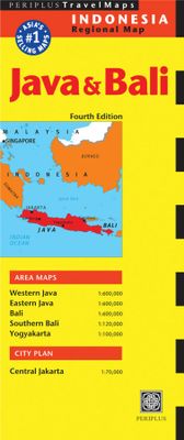
Goede overzichtskaart van zowel Java als Bali. Door kleurgebruik met name hoogtes goed zichtbaar. Met afstandstabel, toeristische aanduidingen. The Java & Bali Travel Map from Periplus is designed as a convenient, easy-to-use tool for travelers. Created using durable coated paper, this map is made to open and fold multiple times, whether it's the ...

Verkopers met dit product

Verkoper
Bezorging
Prijs
DeZwerver.nl logo
DeZwerver.nl
2,95
11,95

Anderen bekeken ook

Wegenkaart - landkaart Indonesië - Indonesia | ITMB
Een degelijke landkaart van Indonesië met aanduidingen van o.a. nationale parken, vliegvelden en grote wegen. Als overzichtskaart goed te gebruiken. De nadruk ligt echter vooral op de natuurkundige aspecten. Scheur- en watervast! Met een kleine kaart van Jakarta. The hundreds of islands making up the island nation of Indonesia make a double-sided map inevitable in order to show any significant amount of detail. Side 1 shows the western half, starting with Sumatra in the upper left and including Java and most of the island of Borneo (Kalimantan Province to the Indonesians). This side also includes a large inset map of central Jakarta (for better detail see our separate map of the city); ditto for Sumatra, Java, and Borneo. Bali, Lombok, and Sumbawa islands are in the lower right portion of the map, and most of Malaysia and all of Singapore are included, simply because they are there. The infamous volcanic island of Krakatoa is located just to the west of Java. The other side of the map…
13,95
Wegenkaart - landkaart Bali & Lombok | Nelles Verlag
Goede wegenkaart van Bali & Lombok. Aan beide kanten bedrukt. Met veel toeristische aanduidingen als nationale parken en culturele bezienswaardigheden. Prima leesbare kaart. One of six maps in a series covering Indonesia, this is a folded road and tourist map of the two Indonesian islands of Bali and Lombok at 1:180 000 scale. Parks, beaches, and places of interest are all highlighted and shaded-relief coloyring clearly depicts the topography.    The map includes insets showing Ubud and it's surroundings at 1:33 000, Denpasar at 1:20 000, Kuta at 1:20 000, Lovina Beach at 1:30 000, Sanur at 1:35 000, Nusa Dua at 1:50 000, the Gili Islands at 1:55 000, Mataram at 1:50 000 and an overview locator map. The legend is in English, French and German.   For over 20 years Nelles maps have been renowned throughout the world for their quality, faithfulness to detail and up-to-dateness.    So that streets, ferry links, railway lines, etc are always up to date, Nelles are continuously upgrading th…
10,95
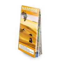
Wegenkaart - landkaart Namibia - Namibië | Tracks4Africa
Uitstekende dubbelzijdige wegenkaart van Namibië, gemaakt door gerenommeerde kaartenmaker Track4Africa in Afrika. Met afstanden en reistijden tussen steden en op alle wegen vermeld. GPS via hun website te downloaden. De kaart wordt door vrijwel elke reisorganisatie geadviseerd als je met een eigen auto in Namibië rond gaat rijden. The Tracks4Africa Namibia paper map is designed to be used in conjunction with the T4A GPS Map of Namibia. It is the largest available Namibia map at 1:1,000,000 scale, offering you the perfect trip planning tool for your next Namibian holiday.  This T4A paper map series are probably the first comprehensive country maps in the world, offering travel time information for the entire road network, be it on tar, gravel or sand!    Key features:    Large 1:1,000,000 scale  Travel times and distances included on the map  What you see on the paper map is exactly what you get on T4A GPS Maps  Comprehensive set of roads and tracks in nature reserves  Detailed in…
27,50
Wegenkaart - landkaart 3005 Adventure Map Bali - Lombok - Komodo | National Geographic
Wegenkaart van Bali, Lombok en Komodo met vermelding van veel bezienswaardigheden, nationale parken en attrakties. Watervast en scheurvast. Juist door deze vermeldingen onderscheidt de kaart zich van andere wegenkaarten. National Geographic's Bali, Lombok, and Komodo Adventure Map is designed to meet the unique needs of adventure travelers to these Indonesian islands with its durability and accurate information. Each folded map provides global travelers with the perfect combination of detail and perspective, highlighting the area’s terrain and best locations for adventure activities like snorkeling, surfing, fishing, and more. Adventure Maps include hundreds of points of interest that highlight diverse and unique destinations within the country.   The map includes the locations of thousands of cities and towns with a user-friendly index, plus a clearly marked road network complete with distances and designations for major highways, main roads, and tracks and trails for those seeking t…
17,50
Reisgids Pocket Bali | Lonely Planet
Een kleine uitvoering van de klassieke Lonely Planet gids: een reisgids met vooral de niet te missen hoogepunten en bezienswaardigheden, maar ook weer doorspekt met meer bijzondere tips en praktische informatie over openbaar vervoer, eten en drinken en accommodaties. Handzame uitvoering. Lonely Planet's local travel experts reveal all you need to know to plan the ultimate short trip to Bali - and discover twice the place in half the time!Discover Bali's most popular experiences, must-see attractions, and unexpected surprises with our handy-sized Pocket travel guide. From taking an impromptu surf lesson on Pantai Batu Bolong Beach, to dancing around the monkeys at the magical Pura Luhur Ulu Watu with mesmerising views, and digging into some of Indonesia's most popular dishes at Pasar Kerobokan night market. Build a trip to remember with Lonely Planet's Pocket Bali travel guide:Our Pocket guidebook format provides you with the best insider knowledge and local know-how for planning trips…
14,95
Wegenkaart - landkaart Java | ITMB
Indonesia is a huge and varied country of many islands and many cultures. The Javanese dominate the country. Not only is the island centrally located, but the rich soil and hard-working people has turned the island into the economic powerhouse driving the country’s economy. Indonesia’s capital, Jakarta, is located on the island’s north shore, and is the subject of a separate ITM map. This map concentrates on the island’s many charms: the temples of Yogyakarta, the colonial architecture of Surabaya, and the rustic charm of mountainous East Java. The map abounds in insets, including central Jakarta at 1:25 000, but also Cirebon, Bandung, and Solo, Semarang, Surabaya, Yogyakarta, Malang, and Yoga to Prambanan at 1:90,000, and the Dieng Plateau at 1:35,000. The famous island of Krakatoa is also included. This map is double-sided (east/west). Roads by classification, ferry route, ruins, bird sanctuary, national parks, volcanoes, non-active volcanoes, hotel, surfing, beaches, waterfalls, hi…
13,95
Wegenkaart - landkaart Bali & Lombok | ITMB
Goede kaart met op de ene zijde Bali, schaal 1:145.000 en op de andere kant Lombok, schaal 1:130.000 Lombok may not be as well-known as Bali, but both Indonesian islands are prime tourist destinations. This edition includes new inset maps of Denpasar, the main city in Bali, as well as maps of the Kuta-Legan and Sanur beach resort areas, and of the northern city of Singaraja. The Lombok map on the reverse side includes a map of Mataram, the principal city and a special inset showing the three Gili Islands off the west coast, with their dozens of resort hotels. Legend Includes: Roads by classification, Airports, Turtle Reserve Area, Bird Sanctuary, Hospitals, Hotels, Park Headquarters, World Heritage, Volcano, Habour, Police Stations, Viewpoints, Beaches, Gas Stations, Mines and much more.  
13,95
Wegenkaart - landkaart Nunavut - Northwest Territories | ITMB
The far north of Canada, north of 60 degrees, consists of three territories; the Yukon, the Northwest Territories, and Nunavut. Until now, there has never been a proper map of the territory that was carved off from the NWT a quarter century ago. With only 30,000 people and a scattering of settlements, Nunavut is larger than western Europe in area. This map took us years to prepare, using 1:250,000 government topo maps as a base and tracing thousands of little lakes. The traditional passageway of the fabled Northwest Passage is also shown. The most northerly civilian community in the world is on the map – Grise Bay, as well as Alert, the most remote place on earth. Originally, the NWT covered all of northwestern North America west of the Louisiana Purchase and the Loyalist colonies, and north of the Spanish provinces (essentially north of current day Sactamento). Political changes have reduced its size over the past century and a half to the region of Canada north of the 60th parallel …
13,95
Wegenkaart - landkaart 3315 Adventure Map Corsica | National Geographic
Wegenkaart van Corsica met vermelding van veel bezienswaardigheden, nationale parken en attrakties. Watervast en scheurvast. Juist door deze vermeldingen onderscheidt de kaart zich van andere wegenkaarten. National Geographic's Corsica Adventure Map is designed to meet the unique needs of adventure travelers with its durability and accurate information. Each folded map provides global travelers with the perfect combination of detail and perspective, highlighting the area’s terrain and best locations for adventure activities like snorkeling, surfing, fishing, and more. Adventure Maps include hundreds of points of interest that highlight diverse and unique destinations within the country.   The map includes the locations of thousands of cities and towns with a user-friendly index, plus a clearly marked road network complete with distances and designations for major highways, main roads, and tracks and trails for those seeking to explore more remote regions. The front side of the Corsica…
17,50
Wegenkaart - landkaart Frankreich Nord - Frankrijk Noord | Kümmerly & Frey
Mooie duidelijke wegenkaart van Noord Frankrijk. Met o.a. campings, wegnummers en bezienswaardigheden aangegeven. Die Strassenkarten von Kümmerly+Frey sind beliebte Begleiter bei der Planung einer Reise, unterwegs oder am Ziel. Die "Blauen", wie sie auch genannt werden, zeichnen sich durch ein übersichtliches Kartenbild und eine präzise Kartografie aus. Das Sortiment umfasst weit über 100 aktuelle Strassen- und Reisekarten. Alle Strassenkarten haben eines gemeinsam: Sie sind von bester Schweizer Qualität. Planen und reisen Sie mit einer blauen Strassenkarte von Kümmerly+Frey und Sie werden überrascht sein, wie viel es zu entdecken und zu erleben gibt.  In the Kümmerly+Frey Road Map France (North) at a scale of 1:600,000, you will find everything you need for orientation and inspiration.   The map shows the main areas of interest from Basel, Strasbourg, Metz, Dijon, Bourges, Paris, Le Mans, Rennes, Nantes, Rouen, Lille, Calais, Brest, etc.   Thanks to the clearly marked, easily readabl…
14,75

Klanten-reviews van Wegenkaart - landkaart Java & Bali | Periplus

Er zijn nog geen beoordelingen voor dit productBen jij de eerste die een review plaatst?

Meer over Wegenkaart - landkaart Java & Bali | Periplus

Productomschrijving

Goede overzichtskaart van zowel Java als Bali. Door kleurgebruik met name hoogtes goed zichtbaar. Met afstandstabel, toeristische aanduidingen.

The Java & Bali Travel Map from Periplus is designed as a convenient, easy-to-use tool for travelers. Created using durable coated paper, this map is made to open and fold multiple times, whether it's the entire map that you want to view or one panel at a time.   Following highways and byways, this map will show you how to maneuver your way to banks, gardens, hotels, golf courses, museums, monuments, restaurants, churches and temples, movie theaters, shopping centers and more!   This 4th edition includes maps and plans that are scaled to:   Area Maps: Western Java 1:600,000 Eastern Java 1:600,000 Bali 1:600,000 Southern Bali 1:120,000 Yogyakarta 1:100,000 City Plan: Central Jakarta 1:70,000 Periplus Travel Maps cover most of the major cities and travel destinations in the Asia-Pacific region. The series includes an amazing variety of fascinating destinations, from the multifaceted subcontinent of India to the bustling city-state of Singapore and the 'western style' metropolis of Sydney to the Asian charms of Bali. All titles are continuously updated, ensuring they keep up with the considerable changes in this fast-developing part of the world. This extensive geographical reach and attention to detail mean that Periplus Travel Maps are the natural first choice for anyone traveling in the region.  

Productinformatie

    Verken gerelateerde categorieën

    Webshop.nl maakt gebruik van cookies. Ga je verder op onze website, ga dan akkoord met het plaatsen van cookies en de verwerking van deze data door ons en vermelde partners.